When Toronto renamed a street – twice

As Toronto City Council looks at renaming Dundas Street over its namesake’s support of slavery within the British empire, it is a reminder that it is not the first time the city has grappled with such an exercise.

Asquith Avenue runs about 350 metres east from Yonge Street just north of Bloor Street in Yorkville. Today, it is most known for being the home of the Toronto Reference Library. Hidden within its history is Asquith is not its original name; in fact, it was renamed twice before.

Asquith Avenue in 2021. Source: Google Maps.

Annexation & Duplication

The origins of Asquith Avenue lay in the 1830s with the independent village of Yorkville. The street was originally known as Jarvis Street, named after one of the village’s builders Sheriff William Botsford Jarvis.

Map of The Incorporated Village of Yorkville in the County of York and Province of Canada, 1852. Source: Historic Maps of Toronto.

When Yorkville was absorbed into the larger City of Toronto in 1883, the annexation created duplication in some street names between the two entities. There was already a Jarvis Street in Toronto (ironically, it is a candidate for renaming today for its own slave-owning connections). Named for Samuel P. Jarvis, it ran from the lake to its head at Bloor Street – and was only short distance away from the Jarvis Street in Yorkville. To avoid confusion, the smaller street was renamed.

“The names of the following streets in St. Paul’s Ward, which conflicted with the names of other streets in Toronto were changed: – William-street to Hawthorn-avenue, Jarvis-street to Bismarck-avenue, Sydenham-street to Cumberland-street, York-street to McMurrich-street, Beverley-street to Boswell-street, Grange-street to Baker-street, Emma-street to Baxter-street, John-street to Roden-place, Balwin-street to Crown-street, Dufferin-street to Bernard-avenue, Victoria-avenue to Dobson-avenue, and Chestnut-avenue to Turner-avenue. The accounts were passed, and the meeting adjourned.”

“Civic Committees”, The Globe, March 7, 1883, pg. 3
Plan of the city of Toronto, 1882: Source: Historic Maps of Toronto

The new name chosen for the former Jarvis Street was Bismarck Avenue. It was named for Otto von Bismarck, the Prussian statesman and later German chancellor who was best known for unifying Germany in the 1870s. The change was proposed by German-born Alderman Newman Leopold Steiner, Toronto’s first Jewish Alderman. In May 1883, Steiner read a communication from Prince Bismarck thanking Council for the naming honour.

Source: Robertson’s Landmarks of Toronto, 1894
22-24 Bismarck (Asquith) Avenue, 1890. Source: Toronto Public Library.
16-20 Bismarck (Asquith) Avenue, Parker’s Dye Works, side entrance, 1910. Source: Toronto Public Library.

“Lose all traces of Prussian Plutocracy”

Bismarck Avenue remained for another thirty years until World War I. Canada joined Great Britain in the Great War against Germany. As result, in 1915, the street name’s relevance came into question.

Alderman J. George Ramsden — the local representative of St. Paul’s Ward where Bismarck Avenue was located and the individual for which Ramsden Park is named for today — was an adamant champion for the street’s renaming. In May 1915, Ramsden presented a petition of 400 signatures of local residents around Bismarck and moved to approve the change. Among the signatories was the Central Methodist Church on Bloor Street, which backed onto Bismarck. According to the Toronto Daily Star, the site of the church was given by the grandfather of one of the victims of the sinking of the Lusitania – an event that stirred great resentment against Germany and its people, even at home. The council meeting went as follows:

“For that reason it was the desire of the petitioners that Bismarck avenue should lose all trace of the German Chancellor and of Prussian plutocracy. (Applause).”

“Refuse to appoint Smith as Head of Fire Department”, Toronto Daily Star, May 18, 1915, pg. 2

The Toronto Daily Star noted the Street Naming Committee normally only met in the fall, but given the circumstances, greater haste was needed. North Toronto previously had a street named for Kaiser Wilhelm, which was renamed by the the committee. Among the new possibilities for Bismarck were “Asquith”, “Kitchener”, and WWI battles in which Canadians prevailed such as “Ypres” and “Neuve Chapelle” (although newspaper also noted Torontonians may have trouble with their pronunciations).

Toronto City Council in its inaugural meeting of 1915. Alderman Ramsden is numbered 14. Source: Toronto Public Library.
Controller Ramsden in 1934. He retired from politics a few years later. Source: Toronto Archives.

At risk of change was more than just Bismarck Avenue, however. “If we change one or two German names, we might as well change all of them,” Alderman Ramsden commented. There were 16 “Teuton” names across the city of Toronto and the goal was to erase any reference to Germany in the city.

An interesting exchange during a Board of Works meeting. “Strachan Ave. Bridge is all a Bungle”, The Globe, July 31, 1915. Source: Globe & Mail Archives

Finally, in August 1915, along with a collection of German-origin names, Bismarck Avenue was formally changed to Asquith Avenue. The Globe explained the move in strong terms:

“No longer will the memory of Bismarck be perpepuated by the nameplate of a Toronto thoroughfare. The memory of the man of iron will be replaced by that of Great Britain’s incomparable statesman, Premier Asquith.”

“Bismarck gives way to British Premier,” The Globe, August 11, 1915, pg. 7
Asquith Avenue’s two former names are noted in the Goad’s Atlas of the City of Toronto, 1924. Source: Goad’s Toronto.

The Power of Names

The history of Asquith Avenue is a great summary of how and why streets are named and/or renamed. In many cases, it is out of necessity to avoid duplication and confusion, often following municipal consolidation. In other situations, they are motivated by the idea of elimination an undesired connotation surrounding that street – that is, either as a re-branding or as a politically-motivated exercise.

In the 1880s, the idea of honouring a German statesman may have made sense. Toronto had a historic community of German settlers and at least one decision-maker of German descent. During World War I, with Toronto and Canada in a conflict with universal ramifications, honouring German ties was perhaps not as obvious. Strengthening the British character of the city — as Toronto often did in other ways, sometimes to very racist outcomes — became a priority. It turned into a deliberate attempt to “erase” all German connections in the city (at least, on the surface).

Names, statues, and monuments reflect the dominant values of the society and people who at the time have the power — both socially and politically — to make those commemorations. The kinds of places that are marked change or should change as that society evolves – or, at least, be afforded the opportunity to hold fair and serious discourse on the possibility of doing so.

Names do not necessarily create, ‘erase’, or ‘sterilize‘ history. They do, however, emphasize and prioritize the types of stories that are told or not told. The history of the naming of Asquith Avenue certainly shows that.

Asquith Avenue in 2019. Source: Google Maps.

Further Reading

“Bismarck Avenue Entrance of Parker’s Dye Works. 791 Yonge Street, Toronto.” Toronto Public Library. Accessed July 12, 2021. https://www.torontopubliclibrary.ca/detail.jsp?Entt=RDMDC-PCR-2140&R=DC-PCR-2140

“Bismarck Gives Way To British Premier.” The Globe, August 11, 1915.

“City Council.” The Globe, May 22, 1883.

“City Fathers Favor Fire Commissioner.” The Globe, May 18, 1915.

“Civic Committees.” The Globe, March 7, 1883.

“German Names for 16 Toronto Streets.” The Toronto Daily Star, May 19, 1915.

Lorinc, | By John. “LORINC: What’s in a Street Name? Dundas and Other Uncomfortable Truths about Our City.” Spacing Toronto, June 12, 2020. http://spacing.ca/toronto/2020/06/12/lorinc-whats-in-a-street-name-dundas-and-other-uncomfortable-truths-about-our-city/

“Refuse to Appoint Smith Head of Fire Department.” The Toronto Daily Star, May 18, 1915.

“Strachan Ave. Bridge Is Still A Bungle.” The Globe, July 31, 1915.

“Toronto Reference Library at 40: The Evolution of Its Site. Part 1. Site and Street Name Changes.” Toronto Reference Library Blog. Accessed July 12, 2021. https://torontopubliclibrary.typepad.com/trl/2017/10/toronto-reference-library-at-40-the-evolution-of-its-site-part-1-site-and-street-name-changes.html

A Toronto ghost sign explained (with a side of tartar sauce)

Recently, the redevelopment of a lot on the southwest corner of Pape and Gamble Avenues revealed an interesting bit of local Toronto history. The result of the removal of a billboard, an intriguing image on the north wall of 1042 Pape Avenue in East York was uncovered, revealing an intriguing tale of a small business and a city’s fascination with a popular dish: fish and chips.

Bunt’s Fish & Chips ghost sign, October 2020. For a detailed image, click here. Credit: Google Maps.

Signs of the past

Ghost signs are or were hand-painted advertisements located on the sides of buildings, which promoted businesses and products. A key to their placement is often the enterprises and subjects contained in the advertisements were situated or available nearby.

A ghost sign promoting Quaker Oats and others was revealed in the Honest Ed’s redevelopment in May 2018. Credit: Bob Georgiou.

This particular ghost sign at 1042 Pape Avenue is curious in that it promotes multiple elements. The top portion displays a slightly faint but distinct Coca-Cola logo. The bottom half is less familiar and carries much of the mystery. It reads:

BUNT’S FISH & CHIPS
WE DELIVER * GE 5213
POST OFFICE AT 1038

1038-1042 Pape Avenue in 2019. Credit: Google Maps.

It is a bit of cruel irony that a billboard covered the ghost sign for many years, as billboards replaced ghost signs as a mass marketing technique. With the big banner taken down, however, it allows us to dive deeper into the sign’s past and answer some important questions:

  • When was this sign painted?
  • Where was Bunt’s Fish & Chips?
  • When did it exist?
  • What about the post office?
Pape Avenue and Gamble Avenue, before redevelopment. A gas station has been at the corner since the 1950s. Credit: Google Maps.

Dating the Bunt’s ghost sign is an interesting task which is aided by a few pieces of context. The heyday of ghost signs as a promotional technique lasted from the early 20th century to about the 1950s or 1960s, with many coming in the Roaring Twenties when Toronto experienced a commercial, industrial, and demographic boom. This sign is particularly well preserved, so unless it was touched up later on as signs sometimes are/were, one can reasonably speculate it originated after 1920. It also may have helped that the billboard was protecting it from the elements. To know for sure, specific details about Bunt’s Fish and Chips and the post office must be uncovered.

A brief history of fish & chips

Working within the first half of the twentieth century, pinpointing the rise in popularity of fish and chips shops in Toronto is a useful exercise. When one thinks of old fish and chips restaurants today, two come to mind: “Len Duckworth’s Fish & Chips” on Danforth Avenue and “Reliable Fish & Chips” on Queen Street East. Both eateries opened in or around 1930. This means the Twenties and Thirties appear to be a good period to learn more about fish and chips restaurants.

Two fish and chips institutions in Toronto. Credit: Google Maps.

In perusing the Toronto City Directories, fish and chips shops first appear as a business type in 1923. 16 shops were listed for that year. Of course, it is very well possible they existed prior to this year. The Globe advertised business opportunities for fish and chip shops as early as 1922. Nonetheless, we can safely point to the mid-1920s as a period they at least became notable. As a point of comparison, in the United Kingdom, the national dish grew in popularity during World War I and hit its apex in 1927 with 35,000 shops across the country. A similar explosion occurred in Toronto: there were 137 fish and chips enterprises in the 1930 City Directory. It only grew from there.

As fish and chip shops rose in popularity, there were new technologies to make frying more efficient. The Globe, October 9, 1924. Credit: Toronto Public Library and Globe & Mail Archives.
The Globe, March 19, 1937. Credit: Toronto Public Library and Globe & Mail archives.

Solving the Bunt’s mystery

From here we can look at the city directories and newspapers beginning the 1920s for any mention of Bunt’s. The first time this occurs is in the 1930s — albeit not on Pape Avenue. A “Bunt’s Fish Store” appears at 908 Broadview Avenue in 1933. Interestingly, The Globe also mentions this shop and address in February 1933, but it is named “Bunt’s Fish and Chips.” In 1937, a separate Bunt’s Fish & Chips opens at 1036 Pape Avenue.

The Globe, February 24, 1933. Credit: Toronto Public Library and Globe & Mail Archives.
Might’s Greater Toronto city directory, 1937. Credit: City of Toronto Archives.

Curiously, there is also a second (or perhaps, third in this case) Bunt’s Fish & Chips at 866 Broadview Avenue in 1937, located several doors down from the original 908 Broadview shop. The original store ceases in the same year, however. The 866 Broadview Bunt’s location does not seem to last long, either; it disappears by 1940.

In 1942, the remaining Bunt’s Fish & Chips at 1036 Pape Avenue moved to 1042 Pape Avenue.  According to Postal History Society of Canada, Sub Post Office No. 109 first appeared on Pape at 1027 in 1925 but moved to 1038 in the same year, where it remained until 1980. It was located at 1032 from 1987 to 1992. Finally, after twenty years in business, according to the lack of entries in the city directories, Bunt’s Fish & Chips also shut its doors in 1956.

Postal History Society of Canada record for Postal Sub 109 at 1038 Pape Avenue.
Credit: Richard E. Ruggle

Might’s Greater Toronto city directory, 1942. Credit: Toronto Public Library

Thus, to date the ghost sign, we must look at the period in which Bunt’s Fish & Chips was located at 1042 Pape Avenue and the Post Office was located at 1038 Pape Avenue. With this, the Bunt’s ghost sign likely went up some time between 1942 and 1956.

Might’s Greater Toronto city directory, 1942. Credit: Toronto Public Library

A legacy continued?

Unfortunately, few details and memories exist or could be located about the inner workings of Bunt’s Fish & Chips. The Coca-Cola advertisement on the ghost sign is appropriate as it likely would have been a drink available at the shop with an order of food. One local East York history recollection recalls that fish sold for 7 cents and chips sold for 5 cents at Bunt’s.

Despite its short twenty-year life, the Bunt’s Fish & Chips’ story is partially captured through this remaining advertisement at its former location. The relic is not only a marker of the business but by extension, Toronto’s intrigue of the humble dish. Finally, another part of its legacy which continues today: the barbecue-themed restaurant now at 1042 Pape Avenue also serves fish and chips.

The Bunt’s Fish & Chips ghost sign as it appeared in June 2021 unfortunately with a graffiti tag. Credit: Bob Georgiou.

Did you ever eat at Bunt’s Fish & Chips or another old fish and chips shop? Leave a comment below!

If you want to read more about the development of this stretch of Pape Avenue in East York, read my article here.

Further reading

Bateman, Chris. “Toronto’s Ghost Signs: Where to Find Traces of Century-Old Ads.” The Globe and Mail, 2 July 2019, www.theglobeandmail.com/canada/toronto/article-torontos-ghost-signs-where-to-find-traces-of-century-old-ads/

“Chipping Away at the History of Fish and Chips.” BBC Travel, BBC, www.bbc.com/travel/article/20130409-chipping-away-at-the-history-of-fish-and-chips.

“Did You Ever Eat at Bunt’s Fish & Chips?” Facebook, Vintage Toronto, www.facebook.com/VintageToronto/posts/5596904233712848

Edwards, Zachary. “Ghost Signs.” MuralForm, Zachary Edwards http://Muralform.com/Wp-Content/Uploads/2014/02/Muralform-Logo-2-300×137.Png, 15 Apr. 2020, muralform.com/2015/ghost-signs/

Hopkin, | By Jeremy. “Sleuthing a Ghost Sign on River Street.” Spacing Toronto, 31 May 2021, spacing.ca/toronto/2021/05/31/sleuthing-a-ghost-sign-on-river-street/.

Jmaxtours. “Toronto Ghost Sign.” Flickr, Yahoo!, 11 Nov. 2020, live-fts.flickr.com/photos/30711218@N00/50588025733/in/pool-tonroto-on/.

Redway, Alan. “East York 1924-1997.” Google Books, Google, books.google.ca/books?id=8TpyDwAAQBAJ&pg=PA281&lpg=PA281&dq=bunt%27s%2Bfish%2Band%2Bchips%2Beast%2Byork%2Bredway&source=bl&ots=QLFlua6CiS&sig=ACfU3U3iuBytSMq1BuFlA-q7gMdX-FIcCw&hl=en&sa=X&ved=2ahUKEwjVtd3kyqLxAhUaX80KHY_pDZMQ6AEwCXoECBIQAw#v=onepage&q=bunt’s%20fish%20and%20chips%20east%20york%20redway&f=false.

Whyilovetoronto. “Why I Love Ghost Signs: The Fading History of…” Why I Love Toronto, 18 Dec. 2015, whyilovetoronto.tumblr.com/post/135400102992.

Scenes From Tommy Thompson Park and The Leslie Street Spit

Tommy Thompson Park and The Leslie Street Spit contain some of the most interesting and oddest landscapes in Toronto. They’ve been called an Urban Wilderness and an Accidental Wilderness. Exploring their history and geography, one can see why. They embody Toronto as a whole: the intriguing and sometimes unexpected intersection of nature and city.


Many Paths, Many Landscapes

First, there’s a careful distinction to be made of the two places. Tommy Thompson Park and the Leslie Street Spit (or the Leslie Spit or just The Spit) are used interchangeably by many people. The reality is one is located within the other. That is to say, the Leslie Spit is a geographic feature and Tommy Thompson Park is the recreational area housed in it.

The entrance of Tommy Thompson Park and the Leslie Spit is located at Unwin Street where it meets the bottom of Leslie Street. If travelling south from Lake Shore Boulevard by road, one is struck by how bizarre a stretch it is. A streetcar barn, a mail facility, a concrete plant, tool and equipment rental place, and most curiously, an allotment garden all make up the scene. At the same time, the Martin Goodman Trail also passes through the area, making bicycle traffic a natural thing for the Spit (the park’s car lot also has a BikeShare station.)

The Baselands just off the entrance is Tommy Thompson Park’s first landscape. This is a thicket of bushes, shrubs, and trees — and rubble. The red-osier dogwood offer some colour in the spring-time grey and brown.

One emerges from Baselands to meet with the Multi-Use Trail, a paved path used by walkers, runners, cyclists, and sometimes park staff vehicles. The trail runs the course of the Spit from the entrance to its most southern tip. If one doesn’t pass through pedestrian bridge nearly half-way through the 5-kilometre length, one can branch out to the north of the cell bays and pass through the Flats and Headlands. The lighthouse is a natural goal and following the multi-use trail to the end offers a great reward. But the side-trails are well worth it too.

The Spit splits into the three paths. Along with the Multi-Use path, there is a Nature Trail and Pedestrian Trail. If on foot, these quiet and more slower-paced alternatives allow one to take in the Spit in a truly unique way.

The Nature Trail on the north side of the main paved path hugs the north shore of the Spit. It offers views of the marina, embayments, and the great skyline of Toronto beyond them all along the way. Numbered trail markers show the way. It is also on the way to the Ecological Bird Research Centre, one of a few scientific and educational functions of the park.

The Pedestrian Trail runs south of the Multi-Use Trail. It offers clear blue lake views, along with views of Cell 1 where wildlife undoubtedly lives. The shores along this trail also show the most interesting debris.

A History of Many Names

The curious history of the Leslie Street Spit started in the late 1950’s and continued into the 1960s. It was designed to be a breakwater for Toronto harbour. For this reason, the official name for the Leslie Spit is the mouthful-ish “Outer Harbour East Headland”. By 1970, a 5-kilometre “arm” made of infill and construction materials extended into the water. The main road on this landform is now the Multi-Use trail. Over the next several decades, several “branches” would be made to jut out from this “spine”, creating endikements and bays. For this reason, the Leslie Spit is better labelled as a man-made peninsula rather than a naturally-occuring spit.

A pre-Leslie Spit eastern Toronto waterfront, 1950. Source: City of Toronto Archives.
“Harbor Headland Ahead Of Schedule” The Globe & Mail, Oct 3, 1968. Source: Toronto Public Library and Globe & Mail Archives.
“The big key to waterfront development”, The Globe & Mail, May 27, 1971. Source: Toronto Public Library and Globe & Mail Archives.

By the early 1970s, the anticipated port activity in Toronto’s waters never materialized. The East Headland became obsolete as a commercial project. As the decade progressed, a curious thing happened. Nature took over. Birds used the peninsula as migratory stop. The potential of the Spit as a recreational area, namely sailing and boating, also entered the conversation. So much so that the area was known as “The Aquatic Park”.

“New park: Do we want wall-to-wall boats?”, The Globe & Mail, Feb 4, 1977. Source: Toronto Public Library and Globe & Mail Archives.

In 1977, a client group consisting of Metro Toronto Regional Conservation Authority and Metro Toronto Park Commission members hired a consultant firm to report on the possibilities of the peninsula. Ideas included a sailing school, marine hotel, camp grounds, a hostel, and a wildlife and nature preserve. Curiously, the north shore of the Spit, already used by recreational boats, was not included in the report. The report put naturalists and recreationists at odds — a theme that continues today. In 1983, the Leslie Street Spit was named “Tommy Thompson Park”, after the longtime Toronto Parks Commissioner. The Toronto & Region Conservation Authority manages the parkland today.

The Leslie Street Spit, 1992. Source: City of Toronto Archives.


Trash or Built Heritage?

A common sight of The Leslie Spit is the piles of bricks, cement blocks, rebar, scrap metal, and more on its trails and on its shores. People have combined two of these elements — the rebar and bricks — to make some makeshift art installations.

It has been said that because the Spit is in a way akin to garbage dump, it is a valuable asset in that it literally is the “archaeology of Toronto”. Indeed, debris excavated to build the downtown subway lines is said to rest at the peninsula. Beyond that, is any of the rubble of the headland actually important?

One brick has the pressing of “F Price” and it may provide an insight into Toronto history a whole. The Prices were a family of brick makers on Greenwood Avenue. The most famous of them are perhaps brothers Isaac Price and John Price — the latter who ran last brickmaking entreprise on Greenwood.

The identity and origin of this “F Price” on this particular brick is a mystery, but may refer to a Fred Price, who was in business in the 1920s. He may have been a brother or son or nephew to the Isaac and John. Fred Price looks to have partnered with a George J Smith. Together they formed Price & Smith, which operated on the west side of Greenwood Avenue north of the railway tracks (where the subway yard now sits). By the mid-1930s, the establishment ceased to appear in the city directories. The historical significance of Price & Smith and brickyards from the same period is in providing the bricks which made the housing stock of Toronto in its growth period after World War I.

“Price & Smith”, The Globe, April 18, 1924. Source: Toronto Public Library and Globe & Mail Archives.

Urban Wilderness

Today, the Leslie Spit is an intriguing refuge for many plants and animals. Some of these are species found in other parts of Toronto, like cattails, goldenrod, trumpeter swans, red-wing black birds, and beavers. Some are to the city as a whole, like bats, owls, and cottonwood trees, which are threatened by the pesky cormorant. The Leslie Spit’s importance as a migratory bird stopover led to it to being declared an “Important Bird Area” by Birdlife International in 2000.

There are two main rules to Tommy Thompson Park: no motorized vehicles and no dogs. Both are to safeguard the peninsula as a habitat to seen and unseen wildlife. The lack of cars is an obvious rule with the exhaust fumes and loudness among other threats providing obvious disruptions. Bikes are allowed and are popular on the Spit, but speeds are capped at 20 km/hour to protect not only pedestrians but wildlife like turtles that may wander onto the path. The dogs or pets policy dates back to the 1980s. Dogs can be a threat to ground-nesting birds and other wildlife. With a population of coyotes on the Spit, pets themselves can also be at risk too.

The balance between human use and environmental respect remains today. With new controversies and challenges arising (like filming), careful stewartship should perserve the Leslie Street Spit for decades and centuries to come!

The Curious History of 28 Jameson Avenue in Parkdale, 1895

In the July 6, 1895 edition of The Globe newspaper, an impressive 14-room house appeared for sale. It was listed at 28 Jameson Avenue in South Parkdale, fronting onto Lake Ontario which a spacious lawn and private boardwalk. The advertisement promoted the property as nothing less than idyllic.

“For Sale at a Sacrifice”, The Globe, July 6, 1895.
Source: Toronto Public Library & Globe and Mail Archives.

At first glance, the listing of 28 Jameson Avenue provides a window into the real estate market and lives of residents of late-Victorian Toronto. While it does accomplish this, the events in the home in the year before this listing offer not only a dark anecdote in Toronto’s history but a dark insight into the potential reasons for its sale only five years after its owners moved in.

The owners of the property were the Westwoods, who moved into the house in 1890, appropriately naming it “Lakeview”. The patriarch, Benjamin Westwood, was a successful industrialist who co-owned “Allcock, Laight and Westwood”, a famous fishing shop on Bay Street. Because of Benjamin’s business forays, the Westwoods were a very well-to-do family, moving from 11 Walmer Road in the Annex to 28 Jameson Avenue. By the time they reached Parkdale, the suburb was only in existence for 20 years and had been annexed by the City of Toronto the year prior, and was filled with other Victorian mansion and affluent families — although not exclusively.

“Mr. Benjamin Westwood”, Evening Star, October 11, 1894.
Source: Toronto Public Library & Toronto Star Archives.
Benjamin Westwood’s “Lakeview”, 28 Jameson Avenue, 1893 Goads Fire Insurance Map.
Source: Goads Toronto.
“Westwood House” Evening Star October 16, 1894.
Source: Toronto Public Library & Toronto Star Archives
“Frank B. Westwood”, Evening Star, October 13, 1894.
Source: Toronto Public Library & Toronto Star Archives.

On the night of Saturday, October 6, 1894, the Westwoods’ lives changed forever. The doorbell rang at Lakeview, and Benjamin’s son, Frank, went to answer it. An unknown character on the other side of the threshold pulled out a gun and “randomly” shot the 18-year old man. As the assailant disappeared, the young Westwood cried out. His mother, Clara Westwood, found him in agony at his front door. Frank Westwood succumbed to his injuries days later and was laid to rest at Mount Pleasant Cemetery.

“It May Be Murder,” The Globe, October 4, 1894.
Source: Toronto Public Library & Globe and Mail Archives

“Mrs. Westwood”, Evening Star, November 28, 1894.
Source: Toronto Public Library & Toronto Star Archives.
“Clara Ford”, Evening Star, November 28, 1894.
Source: Toronto Public Library & Toronto Star Archives.

The murder captured newspaper headlines for weeks and months following the unfortunate event. The police identified, Clara Ford, a 33-year old of mixed race who grew up in Toronto’s ‘Ward’ neighbourhood and was known to dress in men’s clothing (as she was accused to have done the night of the murder). After police questioning, she admitted to gaining revenge on her neighbour Frank Westwood who harassed her for her darker complexion and ultimately sexually assaulted her. In Ford’s trial the following year, the woman was acquitted, claiming that her confession was forced and false. Clara Ford was set free and soon left Toronto. Little is known of her fate after the events of the trial. She was later falsely accused by a journalist critic of Ford of boasting that she did kill Westwood. The murder itself remains unsolved.

Although much was made of the sensationalist trial, the fate of Clara and Benjamin Westwood after the events of 1894-5 is less discussed. The family put Lakeview up for sale months after Ford was found not guilty. One can imagine their heartache in living in the home where the horrific event took place. The 1895 Might’s Toronto City Directory listed the occupants of 28 Jameson Avenue as ‘Vacant’, but the following year’s Directory noted ‘Benjamin Westwood’ at the address once again. An 1896 Globe article confirmed the house was still unsold two years after Frank Westwood’s death. The publication also noted Westwood was living at the address in 1897. Ultimately, the house went to George Edwards, who lived in the house by 1899.

“Sixth Ward Values”, The Globe, July 28, 1896.
Source: Toronto Public Library & Globe and Mail Archives.
“Dau’s Toronto, Hamilton and London Blue Book, 1908”.
Source: Toronto Public Library.

Leaving Parkdale, the Westwoods looked to continue with their lives in other, perhaps familiar areas of Toronto. They first moved into a home on Bloor Street East near Huntley Street. By 1902 however, they found themselves in the high society of Rosedale at 90 Scarth Road, often making the newspaper’s “Social” column and the Blue Book. A ‘quiet’ wedding of their daughter to a Chicago man took place in the residence in 1909.

Benjamin Westwood himself died in 1935 at the age of 90. By this time, he and his wife lived on St. Clair West near Yonge Street. The elder Westwood was buried at Mount Pleasant Cemetery where his son was laid to rest nearly 40 years prior. None of the houses the family lived in after (and even before) Lakeview stand today.

“Dau’s Toronto, Hamilton and London Blue Book, 1908” Preface. Source: Toronto Public Library.
“Dau’s Toronto, Hamilton and London Blue Book, 1908”, Benjamin Westwood Listing.
Source: Toronto Public Library.

For 28 Jameson Avenue itself, the future was also not as fortunate after the Westwoods left the property. By 1910, George Edwards moved out of the home and Arthur Penman came in. In the mid-1920s, Lake Shore Boulevard West was constructed just north of the address, using Laburnam Avenue as its right of way. It looks as though the home survived expropriation at that time. Penman was seemingly the final owner of 28 Jameson Avenue, however, as the address last appeared in the Might’s Toronto City Directory in 1931. Thirty years after the creative destructive effects of Lake Shore Boulevard West, the Gardiner Expressway obliterated the rest of South Parkdale in the mid-1950s.

Today, the existence of the Westwoods’ Lakeview mansion is undetectable. Its violent history some 125-years ago is hidden somewhere in the grassy parkland between the Martin Goodman Trail and Lake Ontario.

Jameson Avenue in 1957, just prior to the installation of the Gardiner Expressway. The Westwood house stood just north of the large mansion at the foot of the street.
Source: City of Toronto Archives.
South Parkdale in 2021.
Source: Toronto Historic Map.
Looking towards the site of 28 Jameson Avenue, 2021.
Source: Google Maps


Useful Links

Bateman, Chris. “The Lost Streets of South Parkdale.” Spacing Toronto, 4 Mar. 2017, www. spacing.ca/toronto/2017/03/04/lost-streets-south-parkdale/

“Digital Toronto City Directories : Toronto City Directories.” Toronto Public Library, www.torontopubliclibrary.ca/history-genealogy/lh-digital-city-directories.jsp.

The Dreams Attached to Places: From Suburb, to Slum, to Urban Village in a Toronto Neighbourhood, 1875-2002, Carolyn Whitzman, MA. A Thesis PDF

“Frank Westwood.” Mount Pleasant Group, https://www.mountpleasantgroup.com/en-CA/General-Information/Our-Monthly-Story/story-archives/mount-pleasant-cemetery/F-Westwood.aspx

Goad’s Atlas of the City of Toronto: Fire Insurance Maps from the Victorian Era, goadstoronto.blogspot.com/

Richard. “# 57 ~ The Strange Case of the Parkdale Mystery.” Toronto Then and Now, 1 Jan. 1970, torontothenandnow.blogspot.com/2015/05/57-strange-case-of-parkdale-mystery.html

Undine. A Murder in Toronto, 1 Jan. 1970, strangeco.blogspot.com/2017/03/a-murder-in-toronto.html

Whitzman, Carolyn. Clara at the Door with a Revolver: The Scandalous Black Suspect, the Exemplary White Son, and the Murder That Shocked Toronto. On Point Press, a UBC Press Imprint, 2023.

The Rise and Fall (and Rise Again) of The Tam!

The following article originally appeared in the 2019 Volume 114 Annual Publication of the York Pioneer and Historical Society. It has been slightly edited and altered.


This work grew out of a 2016 walkabout article I wrote (to date, the most engaging piece I have produced) and a 2018 Jane’s Walk I led, both in efforts of telling the story of this historical Scarborough landmark. It was also inspired by several posts in the Scarborough, Looking Back… Facebook Group which highlights fond memories of The Tam and its fire.


If you have recollection of the old Tam O’Shanter Golf Club, please let me know or leave a comment below!


The Rise and Fall (and Rise Again) of The Tam!
By Bob Georgiou


The afternoon of October 3, 1971 was rough for the beloved Tam O’Shanter Golf, Curling, and Skating Club in Agincourt. On that day, the recreation centre of the Scarborough landmark burned to the ground.


The fire broke out around 4:30pm in the lounge of the curling complex after hockey mats inexplicably erupted in flames. The fire swept quickly through the building, feeding on the varnished woodwork. By 4:40pm, the complex was completely enveloped in flames.


Toronto Daily Star, Nov 4, 1971


Upwards of 10,000 people converged on the smoldering building, reported the Globe and Mail and Toronto Daily Star. Many of them arrived from afar, following the smoke trail. Ontario Police blocked off the area around Kennedy Road and Sheppard Avenue to allow emergency vehicles to reach the site. Firefighters battled the flames – but to no avail. Spectators watched from the parking lot of the recently -opened Agincourt Mall as the centre’s characteristic arches collapsed into the rubble.


The damage was devastating. The recreation complex was gone. Long-time Tam O’Shanter owner William G. Sparkhall vowed that day to rebuild the complex within a year, stating it would be better than the wooden construction that made it so vulnerable against the merciless embers. “I’ve spent a lifetime building this club up and I’m not going to stop now,” Sparkwell declared. “It cost me $1.5 million to build it and it will probably cost me $2.5 million to rebuild it.” The loss was otherwise estimated at $2 million.


Tam O’Shanter Fire, 1971 Credit: Toronto Public Library


There were fortunately no casualties on that hot October day. Staff had ushered to safety all two hundred children taking figure skating lessons. Still, the event called into question the future of the club’s hockey and curling operations, which hosted hockey league matches, a prominent hockey school, and one of the best curling facilities in Ontario and Canada.


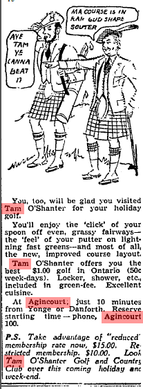
The life of ‘the Tam’ began in 1933 when George Sparkhall, William’s father, purchased a 160-acre cattle farm on the south half of lot 29 concession 3, now the east side of Kennedy Road north of Sheppard Avenue. Using a barn as a clubhouse, Sparkhall turned the lot into a 104-acre pay-as-you-play golf course, calling it ‘Meadowbrook’, presumably referring to the meandering west branch of the Highland Creek situated in its southern end.


Globe & Mail, June 30, 1937


Globe & Mail, July 11, 1938


In the following years, the golf and country club served as social gathering point for the area, hosting banquets, weddings, dances, and other events such as the 1948 Easter party to kick off a $100,000 campaign for a new North Scarboro Memorial Centre.


In 1947, the Tam applied for a dining room and a lounge liquor serving license, under the recently enacted Liquor License Act, 1946. Under the provisions of the new law, residents could protest an application made within their district. A group of Agincourt residents did just that when 400 of them petitioned to oppose the Tam O’Shanter application, explaining that there had never been a need for the sale of beer in the village, the club house was used by teenagers for parties, and as the Tam was located on two major streets, the license would encourage drinking and driving. Owner William Sparkhall answered that the country club was actually outside the district’s borders and the application was only meant to sell beer to members.


Dance at Tam O’Shanter Boys Club, November 15, 1956. Credit: Toronto Archives


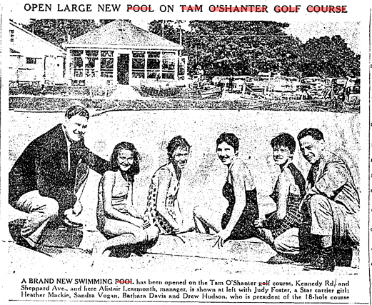
Over the years, the younger Sparkhall, who purchased the golf course from his father in 1938 and renamed it Tam O’Shanter, undertook several upgrades to the property, and added an adjacent lot bordering Birchmount Road. In 1954, the club improved several holes in its 18-hole course, and upgraded its clubhouse and dining room. Two summers later, members and visitors had access to the new and popular Emerald Pool.


Toronto Daily Star July 31, 1956


In 1958, a game-changing addition came in the form of a 12-sheet curling rink. The modernist structure was constructed of fieldstone and housed spectators’ galleries behind three four-sheet sections. It was the “largest in Canada devoted entirely to curling”. The Globe and Mail boasted that even before construction had completed, the club already had a “considerable response to a membership campaign” for new curlers. At this time, the main clubhouse added bowling alleys, two dance floors, two dining areas, and three lounges. Eight more curling sheets followed in 1961. The following year, the Tam could pride itself on “a rink six inches wider than that of Maple Leaf Gardens.” Together, the improvements made the Tam into a formidable and beloved social, sporting, and recreational venue.


Globe & Mail, Feb 26, 1958


While Sparkhall vowed golf would continue as usual after the fire (and indeed it reopened the next day and the following season), most of the club’s functions were severely compromised. A 3-day Oktoberfest scheduled to take place on the Tam grounds that weekend was shortened to a 1-day event at a different venue. Worse, however, the upcoming hockey season was greatly affected by the lack of a rink. The Wexford Hockey Association, whose teams played out of the Tam O’Shanter Arena, scrambled to find other facilities to host its games. North York Mayor Basil Hall elected to bring the matter to Metro Regional Council to see if it could offer assistance in relocating games.


Bruce and Margaret Hyland had to consider their next steps, too. The 5-time Olympic coaches — legendary figures in Canadian skating — ran a popular summer hockey school and the Canada Skating Club at the Tam. The hockey school was one of the largest in the world; Canadian hockey greats Frank and Peter Mahovlich, Kent Douglas, Paul Henderson, and Eddie Shack practiced at Tam O’Shanter Arena. The skating school was supposed to start a day after the fire. By December 1971 though, the Hylands announced initial plans for a $2 million arena built “on four acres of land between Victoria Park Avenue and Don Mills Road, just south of Finch Avenue.” It would be called the Hyland Ice Skating Centre.


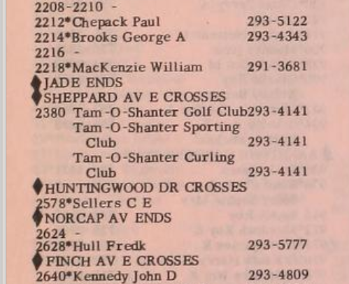
1969 Toronto City Directory of Kennedy Road. Credit: Toronto Public Library.


The club’s 300 curling members elected to remain together, and used membership dues to lease space offered by other clubs in the Toronto area. In June 1972, officials at the Tam-Heather curling club announced they were ready to resume their activities in October of that year. They hoped a new sports complex would be ready by the first anniversary of the fire at Tam O’Shanter.
Interestingly, despite William Sparkhall’s declaration to have the recreation centre up and running in 1972, he – under the Tam-Land Estates Ltd. banner – applied shortly after the fire to rezone the 118-acre golf course to accommodate residential and commercial enterprises. The golf course at the time was zoned for agriculture in its western half and recreation in its eastern half. Tam-Land Estates planned to build a housing and high-rise development on the property. Community opposition, led by future Scarborough Controller and Mayor Joyce Trimmer, successfully fought to keep the area as open public space, harnessing the power of Trimmer’s adamant and ultimately effective letter writing campaign.


These debates around the future of the Tam O’Shanter site also coincided with Metro Parks Commissioner Thomas Thompson’s desire to acquire more parkland for Metro Toronto. The events following Hurricane Hazel in 1954 led the Metro Toronto and Region Conservation Authority (MTRCA) to acquire flood valleys that would push Metro’s parkland to nearly 7,000 acres. However, outside of ravine lands, the region was in short supply of recreation lands to service its expected growth. A potential solution was the acquisition and transformation of private golf courses as they became available.


In what the Globe And Mail called “a bold step toward parks’, Metro Parks Committee allotted $5 million dollars in Metro Council’s 1972 budget to acquire the 165-acre York Downs Golf Course in the Bathurst Street and Sheppard Avenue area and the 118-acre Tam O’Shanter Golf Club in Scarborough. The amount was more than double what Metro spent on parkland acquisition in the previous 10 years. A special subcommittee consisting of Metro Chair Albert Campbell, North York Mayor Basil Hall, Scarborough Mayor Robert White, Metro Parks Commissioner T.W. Thompson, and Metro Planning Commissioner Wojctech Wronski also pushed back Sparkhall’s redevelopment proposal indefinitely so that it could study and report on the possibility of acquiring Tam O’Shanter and York Downs.


With news of the Tam’s availability as potential park space, decision-makers and media urged the purchase. As one Toronto Star editorial put it, Metro Council had to “grab the chance for green space”. It argued that Tam O’Shanter was parkland “in a crowded area” and “there was no obvious recreational land coming on the market nearby.” New Metro Chairman Paul Godfrey called the chance “a golden opportunity that won’t come again”. Another positive was it would not require the demolition of any homes, which was notable because Thomas Thompson’s Metro Parks Committee was also recommending the demolition of 254 houses on the Toronto Islands to create more parkland.


With the sub-committee’s final decision to ultimately buy the course, questions in 1973 revolved around who would pay, how they would pay, and how much they would pay. Metro had $3.5 million budgeted for parks for the next five years; if it took a gander on Tam, it could affect its ability to acquire other parks. Scarborough Controller Karl Mallette added that Scarborough taxpayers could “easily afford” a raise on taxes to pay for new parkland and facilities, such as the new park at Tam O’Shanter. In February of that year, Campbell announced a proposal of a three-way agreement which would see the Ontario government cover half the course’s costs and Metro and Scarborough covering a quarter each. The same formula was used to purchase the York Downs Course. An unknown factor was Tam-Land Estates’ asking price, which was reportedly between $12,000 to $100,000 an acre. In September 1973, the price was eventually set at $10.8 million, a number that had East York Mayor Willis Blair suspecting was too rich. However, two different appraisals valued the land at $10.6 million and $11 million.


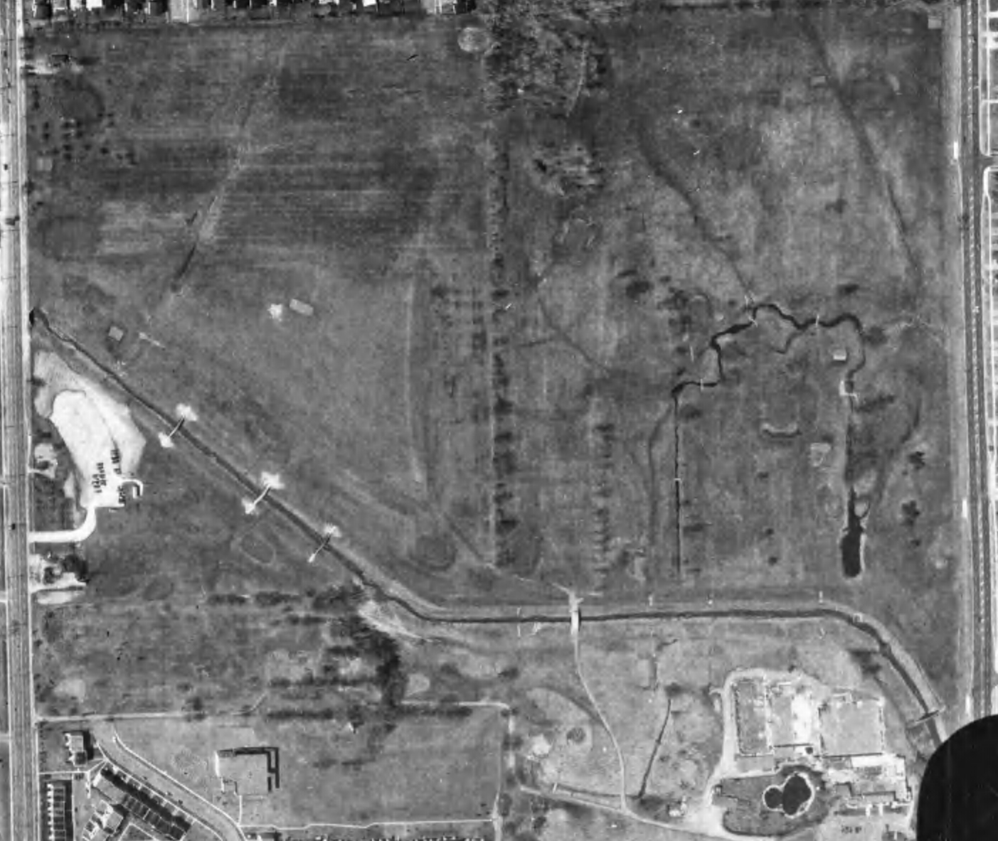
Aerial view of the Tam O’Shanter Golf Course, 1975. Bridges that formerly crossed the West Highland Creek were removed, possibly as the course was awaiting reorganization.


Meanwhile, the Tam’s curling club and hockey and skating schools happily found new homes. Boasting a membership of 540 and set to reach capacity of 640 by the start of the following season, the Tam-Heather Curling Club opened its new eight-sheet, $500,000 complex in March 1973 at Morningside Avenue and Highway 401. Also in 1973, Bruce and Margaret Hyland successfully opened Metropolitan Ice Skating School (later Centre Ice) on Victoria Park Avenue. The complex had three ice surfaces, one of which Mr. Hyland operated a hockey school.


Finally, two years after the fire that devastated the Tam, officials met in Metro Chairman Paul Godfrey’s office to formalize the purchase of Tam O’Shanter Golf Club. On November 10, 1973, William Sparkhall, president of Tam Land Estates, accepted two cheques totalling $10,825,000 for the 118-acre golf course from Godfrey, Education Minister Thomas Wells, Scarborough Mayor Paul Cosgrove, and Fred Wade, chairman of the MTRCA. Tam-Land Estates retained some land for its own redevelopment purposes. With the purchase of Tam and York Downs, Metro Parks also recommended the creation of an inventory of other private courses with the goal of purchasing them in the future. The MTRCA would officially own Tam O’Shanter, but Metro Parks would oversee it.


Following the acquisition, several outlying details remained about the function and form of the new Tam O’Shanter. Scarborough Council disagreed with Metro about the property’s apparent decided future as a municipal golf course. The borough understood that the option was open for it to become a park, and even though discussions during negotiations mentioned that Tam O’Shanter could either continue as a golf course or become a park or a mixture of the two, there was no formal resolution. Wells, the Progressive Conservative representative of Scarborough North, the provincial riding housing Tam O’Shanter, asserted in a February 1973 edition of the Globe and Mail, “It is essential that this site be retained as open space but not necessarily as an 18-hole golf course.” Despite the disagreement, new Metro Committee Parks Commissioner Robert Bundy said the site was “well located for a golf course” and Tam O’Shanter remained a public course – possibly because it was one of the only courses in the east end of Metro Toronto.
The golf course required major upgrades, however. While minor improvements kept the golf club operational through the 1970s, the quality of the greens, which required a new irrigation system, was so poor that Metro Parks lowered its fees in 1975 by 50 cents. With the damage to and the eventual demolition of the old Tam complex in the years after the purchase, the course also required a new clubhouse. In the first half of the 1980s, Tam O’Shanter underwent $800,000 worth of upgrades to update and reconfigure its course with a new entrance of Birchmount Road. Its new clubhouse opened on May 7, 1982.


Aerial, 1983. Credit: City of Toronto Archives


In 1985, Sparkhall and Co. – seemingly the new banner of Tam-Lands Estates Limited – looked to redevelop the land south of the course and north of Agincourt Mall. It proposed, and was allowed to build “1000 apartments, 23,225 square metres (250,000 square feet) of offices, up to 6,040 metres (65,000 square feet) of commercial use, libraries, day nursey, and educational facilities on 6.16 hectares (15.23 acres) of land on Kennedy north of Bonis [Avenue].”
Just as there had been opposition in 1971, residents of Bonis Avenue mobilized to fight the proposal. The community assembled a petition of 500 names and packed the Scarborough Council chambers in March 1985 to voice disapproval of their neighbourhood becoming “a mini-downtown.” Along with the scale of the development, another sticking point was the proposed extension of Bonis, which was at the time a dead-end street running east from Birchmount Road, stopping at the old lot border. The plan called for its lengthening to connect with Cardwell Avenue at Kennedy Road. Residents, including Controller Joyce Trimmer (who beat out former Controller Karl Malette in the 1974 election), argued that the street would only serve as a high-speed detour for Sheppard Avenue traffic. After more consultations, the project did not go through.


Plans for development along Bonis Avenue surfaced again in 1988, this time spearheaded by Tridel Corporation. The new proposal involved “four 24-storey condo towers with a total of 1,112 units, a five-story building with 7,961 square metres of office space, a one-story building with 5,580 square metres of retail space, and two-storey, 1953-square metre public library.” The inclusion of a library was notable because a 1977 plan suggested the erection of a much-needed district library on a portion of the Tam O’Shanter property turned over to Scarborough for municipal parkland. This was opposed by Trimmer and was ultimately nixed by Metro planners.
Despite being a slightly more scaled back version of the Sparkhall and Co. project, Tridel Corp. faced similar challenges and objections as its predecessor. As was the case three years ago, the property, zoned for institutional and recreational use, would have to be rezoned. Planning and traffic studies again recommended an extension of Bonis Avenue. Opponents said the development had double the amount of allowed units. The Highland Heights Community Association warned the street would become a ‘traffic nightmare’, which would bring in 1,000 cars in the evening rush hour (Tridel contended 335 cars). Even with the opposition, calls for the developer to scrap the project largely went unheard.


In October 1988, despite last minute objections, Scarborough council approved the $500-million dollar project behind Agincourt Mall. It was the second major condo project approved in the span of a month in the borough. On September 6, Council approved $1.5 billion, 2,420-unit development – also by Tridel – at the Scarborough Civic Centre.


As a part of the Agincourt deal, Scarborough also received a 1,200-square-metre parcel of land worth more than $300,000 for a $4.5 million library. Tridel also gifted $500,000 for its construction as well as $1.6 million for day care, park development and landscaping. The new Agincourt Library branch opened in 1991 on Bonis, moving from Agincourt Mall and continuing a legacy dating back to 1918.


Also in 1991, ‘The Greens at Tam O’Shanter’, the first tower in the phased project, opened. Described by a 1989 Toronto Star ad as “a magnificent collection of country club style residences overlooking the manicured greens and fairways of the renowned Tam O’Shanter Golf course in Scarborough”, it is a 24-storey construction with “211 one, two and three bedroom suites – many of which open up onto private terraces” which “range from 787 square feet to 1,782 square feet. Its marketing harnessed “the royal and ancient” tradition of golf as it was played on old Scottish courses like St. Andrews and Leith Links, when the game “was the sport of kings”. Although it did not do so in the end, the advertisement could have also referenced the 50+ year history of golf at Tam O’Shanter.


Toronto Star, Oct 7, 1989


The next parts of the Tridel complex – 28 brownstone townhouses and 3 more 24-storey condos – would open over the next twenty years. One of the condos – 1998’s “The Highlands at Tam O’Shanter” at 228 Bonis Avenue – roughly occupies the former site of the Tam’s famed clubhouse and recreation centre.


Today, the Tam O’Shanter Golf Clube operates an 18-hole, Par 72 course from mid-April to mid-November.

Scenes From The Alexander Muir Memorial Gardens

The Alexander Muir Memorial Gardens is a beautiful park in midtown Toronto which dates back almost ninety years. The cause to memorialize its namesake Alexander Muir was so great that he had the gardens dedicated to him twice.

Alexander Muir Memorial Gardens, 2020. Source: Google Maps.

The first Alexander Muir Memorial Gardens was located near Lawton Boulevard. It was in a triangular plot of land caused by the unusual eastward veering of Yonge Street near Heath Street. The “correction” was made to directly align Yonge Street in the original Town of York with Lake Simcoe when the street was originally surveyed in the 1790s. Yellow Creek flowed through the park.

Tremaine’s Map of the County of York, Canada West, 1860. Source: Old Toronto Maps.

With construction beginning in 1933, the Alexander Muir Memorial Gardens were officially opened on August 6, 1934. It was established 24 years after Muir’s death on June 26, 1906. The Gardens were located directly across Mount Pleasant Cemetery — his final resting spot.

Alexander Muir Memorial Gardens, 1934. Source: City of Toronto Archives.

“Alexander Muir Memorial Garden Officially Opened”, The Globe August 7, 1934. Source: Globe and Mail Archives & Toronto Public Library.

Alexander Muir Memorial Gardens, 1947. Source: City of Toronto Archives.

The entrance to the gardens featured an ornamental gate at Yonge Street. This led to an impressive stone wall and terrace with a carving of a verse of ‘The Maple Leaf Forever” — Alexander Muir’s best known work. In the garden were 1,000 rose bushes and a well-manicured lawn. In the north of the park was a sunken rockery garden and lily pools below a willow tree. Other ‘Canadian’ trees and Japanese cherry trees were also planted.

Old Alexander Muir Memorial Gardens Gates, 1935. Source: City of Toronto Archives.

Old Alexander Muir Memorial Gardens, 1935. Source: City of Toronto Archives.

Old Alexander Muir Memorial Gardens with Mount Pleasant Cemetery, 1935. Source: City of Toronto Archives.

Old Alexander Muir Memorial Gardens ravine or pond, 1935. Source: City of Toronto Archives.

Alexander Muir himself was a hero of sorts of old, colonial, British Toronto, so the appetite to pay tribute to him in the 1930s was high, especially with centennial celebration of incorporation of the City of Toronto happening in the decade. Among other identities, Muir was a patriot, educator, and composer. In addition to Yonge Street, Muir’s geographic footprint stretches across Toronto from Scarborough to Leslieville to Little Portugal — all school sites associated with him late 19th century.

Muir, Alexander, 1830-1906, 1855. Source: Toronto Public Library.

His ‘Maple Leaf Forever’ is an anthem for British Canada. Its original lyrics made a point of celebrating General Wolfe — the man who led the English to victory over the French at the Plains of Abraham — and highlighted scrimmages in the War of 1812 — a conflict used heavily in the construction of  ‘Canadiana’. His funeral in 1906 was “impressive” and attended by “hundreds”, including the many older Toronto organizations Muir was affiliated with — the Loyal Orange Association, the York Pioneers, the Independent Order of Oddfellows, and others.

Muir, Alexander, gravestone, Mount Pleasant Cemetery, 1920. Source: Toronto Public Library.

In the 1950s, Toronto’s character was changing — both culturally and physically. The coming of Yonge Street subway almost spelled the disappearance of the Alexander Muir Memorial Gardens. The Toronto Transit Commission needed to fill in the ravine to make way for the Davisville Yard. The TTC eventually pledged to cover the $100,000 cost of moving the memorial. Proposed new sites for the gardens included on Lawton Boulevard itself which would have removed four houses and on Gladstone Avenue where Muir himself once worked. Eventually, a spot only several blocks north on Yonge Street was chosen.

“Subway Forces Move of Muir Memorial”, The Globe, December 29, 1950. Source: Globe and Mail Archives & Toronto Public Library.

Davisville Yard, 1956. Source: City of Toronto Archives.

The new location for the Alexander Muir Memorial Gardens was located near St. Edmunds Drive. The Lawrence Park neighbourhood was laid out in 1908 as a garden suburb with winding streets and comfortably sized lots. It also kept a ravine space extending south from the southeast corner of Yonge and Lawrence as parkland. This area would come to house the new Alexander Muir Memorial Gardens. In preparation, several hundred trees were cut down. A red maple from the old park was also moved to the new park.

Lawrence Park, 1934. Source: City of Toronto Archives.

Lawrence Park, 1947. Source: City of Toronto Archives.

The new Alexander Muir Memorial Gardens opened in Lawrence Park on May 28, 1952. Impressively, the wall and terrace were reconstructed in the new location and new trees and gardens were landscaped. A new, maple leaf-ornamented plaque was added to the gates to mark the occasion.

“Alexander Muir Memorial Gardens,”, The Globe, May 23, 1952. Source: Globe and Mail Archives & Toronto Public Library.

Alexander Muir Memorial Gardens, 1952. Source: City of Toronto Archives.

Alexander Muir Memorial Gardens terrace, 1952. Source: City of Toronto Archives.

Alexander Muir Memorial Gardens, 1956. Source: City of Toronto Archives.

A walk through the Alexander Muir Gardens today is a marvel. Leading from the gates is almost a labyrinth of paths and corners to discover. Well-presented flora and accompanying fauna catch one’s eye at almost every look.


Leading off the spacious lawn in the west part of the Alexander Muir Gardens, the park’s contours show themselves on the way up to Dawlish Avenue. This tree-covered topography hides Burke Brook, a Don River tributary. Following Alexander Muir Road past the tennis and lawn bowling courts, the trail continues through several parks ending at Sunnybrook Park.

As it has historically, the central wall and stairs rightfully remain the focal point of the Alexander Muir Memorial Gardens. In its modern use, the structure is best known as a popular destination for wedding parties. One wonders how much would-be brides and grooms and other park users have a look at the additional words of re-dedication which accompany the poem by Muir and reflect on his legacy and origins of the park. With everything that may come with it, Muir loved his country, and his profession in education is generally a commendable one.

In a current social climate in which the focus of commemorating Toronto history should be on untold stories rather than its colonial figures, these Memorial Gardens likely would not be a priority if they were created today. But alas, their visual beauty is a positive. Alexander Muir and his poem still live on today within the park.

Scenes From Rouge National Urban Park – Twyn Rivers Drive & Orchard Trail

Twyn Rivers Drive is a curious street in the eastern fringes of Toronto. In a larger metropolis where farms and fields have been replaced by residences and populations, Twyn Rivers Drive is slightly rural in nature and still has visible links to its past.

Twyn Rivers Drive, 2020. Source: Google Maps

Country within The City

Located in the Rouge River Valley, Twyn Rivers Drive’s rural character is very well apparent. First, it’s a two-lane street lacking any sidewalks. Motor vehicles, bicycles, pedestrians, and even wildlife all have to carefully negotiate use of the street. Like some country roads, Twyn Rivers’ route across the valley is not direct. There are slopes, curves, and two near 90 degree turns. It has to navigate what may be the most varied topography in the city. Its path starts with a winding descent from Scarborough’s Sheppard Avenue and eventually on the other side on Sheppard Avenue…in Pickering.

Twyn Rivers Drive, 2018. Source: Google Maps.

Twyn Rivers From The Pleistocene of the Toronto Region, 1932. Source: University of Toronto Map & Data Library.

A History of Twyn Rivers Drive

The historical beginnings of Twyn Rivers Drive is an obvious question, but unfortunately, it does not have an obvious answer. It is old for sure. A September 2017 City of Toronto Traffic Operations Review characterizes Twyn Rivers Drive as “a legacy road from colonial times” and speculates that it is about 200 years old. A June 2017 CBC article says Twyn Rivers Drive is “more than 100-years old” and its main purpose was to get horses to the mills in the valley. Neither report provide any historical context to back up the claims. Twyn Rivers Drive seems to first appear in a 1916 map of Toronto and its surrounding townships, so a hundred years may be accurate at the least.

Twyn Rivers from Map of the Townships, York, Scarboro, and Etobicoke, 1916. Source: University of Toronto Map & Data Library

The naming of Twyn Rivers Drive likely also goes back to its geography. It possibly derives from the Clarence Purcell’s ‘Twyn Waters’ ranch located in the Rouge Valley on what is now Twyn Rivers Drive. The twin rivers in this case are the famed Rouge River and its lesser known brother, the Little Rouge Creek. It is unknown when Twyn Rivers Drive was actually named, but the Twyn Waters ranch existed by the 1930s.

“Picnikers Enjoy Western Hospitality,” Globe and Mail, July 6, 1939. Source: Toronto Public Library and Globe and Mail Archives.

Twyn Rivers Drive in Might’s Greater Toronto city directory, 1969. Source: Toronto Public Library.

Two Rivers, Two Bridges

Twyn Rivers Drive travels over two bridges over the mentioned waterways. The first of these over the Rouge River is a single-lane, metal truss construction. It is named “Stott’s Bridge“. Few details are available about the age and origin of this bridge, but it seems to share a surname with William Stotts, who had his estate house, Glen Eagles Manor, further up the hill at the modern junction of Twyn Rivers Drive and Sheppard Avenue East. The house later became the Glen Eagles Hotel.

Stott’s Bridge, 2019. Source: Google Maps.

William Stotts from Nason’s east and west ridings of the county of York or townships of Etobicoke, Markham, Scarboro’, Vaughan & York directory, 1871. Stott’s property was located on Concession 2 (now Ellesmere Road), on north half of lot #3. He is listed as a freeholding farmer. Highland Creek likely denotes the post office Stotts used. Source: Toronto Public Library.

Twyn Rivers From Tremaine’s Map of the County of York, Canada West, 1860. Source: Old Toronto Maps.

The second causeway is a white arched bridge over the Little Rouge Creek. “Maxwell’s Bridge” is a concrete structure which accommodates two lane traffic. It is at least the second or possibly third version of a water crossing in this location. An antique wooden bridge collapsed in 1914 after a heavy vehicle passed over it. A new bridge was soon ordered to be built. In 1927, Scarboro Township Council funded the construction of a new rainbow arch bridge with a 60-foot span at a cost of $7,797. Several other arch bridges were built in the Nineteen Tens and Nineteen Twenties Kirkham’s Road over the Rouge River in 1910, Don River Boulevard over the West Don River in 1928, and Don Mills Road over the Don River in 1921.

“Antique Bridge Collapses”, Toronto Daily Star, August 7, 1914. Source: Toronto Public Library and Toronto Star Archives.

“BRIDGE AT KIRKHAM’S MILLS”, Globe and Mail, September 13, 1910. Source: Toronto Public Library and Globe and Mail Archives

Maxwell’s Mill

Nearby Maxwell’s Bridge where Twyn Rivers Drive does its second bend are the ruins of a grist mill named “Maxwell’s Mill”. The site was built by a James Maxwell in the 1800s. In 1923, Maxwell sold it to Clarence Purcell who used it to raise livestock on his Twyn Waters ranch.

Twyn Rivers from Illustrated Historical Atlas of the County of York, 1878. Maxwell’s Mill is the Grist Mill labelled on his lot. Source: Old Toronto Maps.

James Maxwell from Nason’s east and west ridings of the county of York or townships of Etobicoke, Markham, Scarboro’, Vaughan & York directory, 1871. Maxwell is listed as a flour mill freeholder with a Post Office at Rouge Hill. His plot of land was located at Concession 3 (now Sheppard Avenue) on lot #2. Source: Toronto Public Library.

MEN OF TREES FAIR AT ‘TWYN WATERS’, Globe and Mail, September 24, 1941. Source: Toronto Public Library and Globe and Mail Archives.

The mill closed in 1929 after a flood weakened it and a fire in the 1970s destroyed much of what remained. Some of the foundations and walls still stand today. An image of Maxwell’s Mill is available on the Scarborough Historical Society’s website.

Mill stone at the Rouge river Twyn River Estate. Toronto, Ont., 1957. Source: Toronto Public Library

The Rouge Valley Inn & Caper Valley Ski Hill

The Rouge Valley Inn (later called the Rouge Valley Olympic Inn) was located on the south side of Twyn Rivers Drive slightly before the Scarborough-Pickering Townline. The site was a major Scarborough attraction in the twentieth century with a hotel, dining, picnicking for families, and “the largest swimming pool in Ontario.” Ambrose Small, the 20th century Ontario theatre titan who mysteriously disappeared in 1919, owned the Rouge Valley Inn for a time starting around 1900.

“Everyday Outings”, Globe and Mail, June 25, 1958. Source: Toronto Public Library and Globe and Mail Archives.

“Rouge Valley Guests” Globe and Mail, August 9, 1940. Source: Toronto Public Library and Globe and Mail Archives.

“$500 Reward,” Toronto Daily Star, January 6, 1920. Source: Toronto Public Library and Toronto Star Archives.

Across the Little Rouge Creek from the Rouge Valley Inn was the Caper Valley Ski Slope, also known as ‘Snake Hill’ for those who used to frequent it. Along with Earl Bales Park and other establishments, it was one of a handful of areas in Metro Toronto that offered the winter passtime. It was operated by Repac, whose name spelled backwards gave the ski hill its moniker. A footbridge linked the inn and the ski slope.

“School children taper at weekly ski outing”, Globe and Mail, January 6, 1972. Source: Toronto Public Library and Globe and Mail Archives.

Caper Valley Ski Hill, 1975. Source: Toronto Public Library.

Twyn Rivers Transformed

By the end of the 1970s, much of the historic landmarks of Twyn Rivers Drive disappeared from its geography. Fire claimed both the Rouge Valley Inn in 1968 and Maxwell’s Mill in 1970. The former site of the hotel is now the parking lot for the Twyn Rivers Rouge Park area. The mill’s ruins make for an interesting place for urban explores. Clarence Purcell sold his Twyn Waters ranch to the Metro Toronto and Region Conservation Authority in 1970, which after Hurricane Hazel in 1954 began to buy other valley and ravine properties for parkland. Today, there are very few residences located in Rouge Valley.

Twyn Rivers Drive, 1953 & 1975. Source: City of Toronto Archives.

By 1973, the Caper Valley Ski Hill was reporting financial difficulty and it too closed by the end of the decade. It now makes for challenging hike in Rouge Park’s Mast Trail. Finally, the Glen Eagles Hotel was also destroyed by fire in 1990, and is now the Glen Eagles Vista park. The site was nearly made condos. Today, most of these are owned and/or managed by Parks Canada.

Glen Eagles Hotel Fire, 1990. Source: Toronto Public Library.

Twyn Rivers Today

Today, Twyn Rivers is quite the nexus for Rouge National Urban Park, being the starting and ending point of multiple trails. The first source of exploration can be enjoyed around the Rouge Park parking lot. The area is situated on the Little Rouge Creek where the foundations of a former dam still stand. A makeshift footbridge crosses the creek where one can walk in the lost tracks of skiers on Snake Hill.

The Orchard Trail

Near Maxwell’s Mill is the southern terminus of the Orchard Trail. The two-kilometre walk slinks within the forest where apple trees grow today. It also offers vistas of the Little Rouge Creek. A particularly stunning area is the ascent/descent near the north end of the trail.

References

clay70, et al. Purcell’s Mill – Twyn Rivers. www.ontarioabandonedplaces.com/Purcell’s-Mill—Twyn-Rivers-abandoned-Ontario_loc5901.html.

Hikingthegta. “Maxwell’s Mill – Rouge Park.” Hiking the GTA, 24 Nov. 2016, hikingthegta.com/2016/11/23/maxwells-mill-rouge-park/.

Noonan, Larry. “STORIES FROM ROUGE PARK: Hurricane Hazel Also Blasted Rouge Valley.” Toronto.com, Toronto.com, 7 June 2016, www.toronto.com/news-story/6709710-stories-from-rouge-park-hurricane-hazel-also-blasted-rouge-valley/.

Noonan, Larry. “STORIES FROM ROUGE PARK: Recalling the Time the Glen Eagles Lands Were Saved from Condo Developers.” Toronto.com, Toronto.com, 4 June 2015, www.toronto.com/news-story/5661631-stories-from-rouge-park-recalling-the-time-the-glen-eagles-lands-were-saved-from-condo-developers/.

Noonan, Larry. “STORIES FROM ROUGE PARK: Rouge Valley Inn’s Owner Was the Subject of Canada’s Largest Manhunt.” Toronto.com, Toronto.com, 2 July 2015, www.toronto.com/news-story/5705937-stories-from-rouge-park-rouge-valley-inn-s-owner-was-the-subject-of-canada-s-largest-manhunt/.

Noonan, Larry. “STORIES FROM ROUGE PARK: The Ruins of Maxwell’s Mill Can Still Be Seen While Driving along Twyn Rivers Drive in Scarborough.” Toronto.com, Toronto.com, 31 Dec. 2015, www.toronto.com/news-story/6214521-stories-from-rouge-park-the-ruins-of-maxwell-s-mill-can-still-be-seen-while-driving-along-twyn-rivers-drive-in-scarborough/.

Parks Canada Agency, Government of Canada. “Twyn Rivers Area.” Twyn Rivers Area – Rouge National Urban Park, 12 Apr. 2019, www.pc.gc.ca/en/pn-np/on/rouge/culture/histoire-history/twyn.

“Pickering Bygone Days.” DurhamRegion.com, 5 May 2015, www.durhamregion.com/community-story/5600442-pickering-bygone-days/.

Scarborough Historical Society, scarboroughhistorical.ca/local-history/communities/hillside/.

“Toronto’s Ravines and Urban Forests.” Google Books, Google, books.google.ca/books?id=2Q37CAAAQBAJ.

“Who Should Use This 100-Year-Old Scarborough Road? Not Trucks, Says Resident | CBC News.” CBCnews, CBC/Radio Canada, 19 July 2017, www.cbc.ca/news/canada/toronto/twyn-rivers-drive-what-should-happen-1.4212333.

The History of College Street and University Avenue

University Avenue and College Street have obvious scholarly connotations. Although the main landmark where these two streets intersect is a political institution, what once stood at the site gives us a fascinating insight into their history, including the lost streets within them.

Aerial of University Avenue and College Street, 2020. Credit: Google Maps.

A New University

In 1827, John Strachan, the archdeacon of the Town of York, was looking for a university for the new colonial settlement. After visiting England, he received a charter for a new school, naming it King’s College, in honour of the monarch of the time. About 150 acres of land was acquired, consisting of park lots 13, 12, and 11 of Lieutenant-Governor John Graves Simcoe’s land division system.

1827 Chewett Plan of the Town of York. Credit: Historical Maps of Toronto.

The assembled land came via three prominent men of early colonial Toronto — D’arcy Boulton (lot 13), Justice William Dummer Powell (lot 12), and John Elmsley (lot 11) — and roughly stretched from today’s Beverley Street to Bay Street and College Street to Bloor Street.

York commercial directory, street guide, and register, 1833-4 : with almanack and calendar for 1834. Credit: Toronto Public Library.

1834 Chewett City of Toronto and Liberties. Credit: Historical Maps of Toronto.

The College Avenue

Along with that 150 acres, two private paths were also laid out: one extending from the property to Lot Street (later Queen Street) — known as The Queen Street Avenue in news articles and maps — and the other to Yonge Street — known as The Yonge Street Avenue. Collectively, these were known as The College Avenue.

City of Toronto in 1834 by E.G.A. Foster ca. 1934. Credit: Historical Maps of Toronto.

Famed architect John Howard was charged with the designing the campus for the new King’s College. The palatial-like structure was intended to evoke grandure. Although his design was ultimately not used, Howard contributed to the would-be campus in 1832 with entrance gates and lodges at Queen Street, controlling access to the university property. Gates were also installed at Yonge Street in 1842 but a gatehouse did not go up until 1852. It is unclear if there were barriers on the western end of the Yonge Street Avenue near modern-day Beverley Street.

King’s College (Proposed), 1835. Credit: Toronto Public Library.

Gates, University Ave., n. side of Queen St. W., 1870. Credit: Toronto Public Library.

Gates, University Ave., n. side, Queen St. W.; lodge, n.w. corner Queen St. & University Ave., 1885. Credit: Toronto Public Library.

Gates, College St., w. side of Yonge St., 1875. Credit: Toronto Public Library.

The End of King’s College & the new University of Toronto

King’s College finally opened in 1843, although Thomas Young rather than John Howard was responsible for the final design. This was the eastern wing of what was intended to be a larger structure. The building was used as a residence with classes being held on Front Street. Much debate plagued the university specifically on whether it should be religiously affiliated.

King’s College, Queen’s Park, e. side of Parliament Buildings., circa 1850s. Credit: Toronto Public Library.

The only-five-year-old structure shut its doors in 1848. The following year, King’s College was no more, becoming the University of Toronto on January 1st, 1850. In the following decade, the unused residence became a Lunatic Asylum for Women. In a search for a site for the national government, a plan fell through in the 1850s to use the Queen’s Park grounds for Parliament Building and Government House. The King’s College building was not part of the plans.

Plan of part of the city of Toronto shewing the town lots on Bellevue for sale by the trustees for the Denison Estate March 1854. Credit: Toronto Public Library.

The University of Toronto established University College in 1853, opening just west of the King’s College site along with a Medical School and Observatory. In 1859, the University of Toronto leased the land around the building to the City of Toronto for 999 years for a public park. This became University Park — or Queen’s Park — as opened by the Prince of Wales in the following year. A provision allowed for a potential future site for the Ontario Parliament, which at the time met at Front Street and Simcoe Street.

Campus Map of area bounded by College, St. George, Bloor and Surrey Place [Plan of the University Park], c. 1859. Credit: Historical Maps of Toronto

Kings College, Queen’s Park, e. side of Parliament Buildings., 1859. Credit: Toronto Public Library.

A Long, Tree-Lined Avenue

The original laying out College Avenue in 1832 consisted of trees and shrubs were mingled together as a sort of wildwood. Famed American landscape gardener André Parmentier designed the road and grounds. Beginning in the 1840s, maps depict trees lining both College Avenues, creating a grand yet exclusive path to the university. Newspaper publisher John Ross Robertson wrote that a Mark Fitzpatrick, the gatekeeper of the College Avenue gatehouse, was responsible for planting the chestnut trees, which had to be brought in from the United States of America. On his visit to Canada in 1842, author Charles Dickens wrote positively on College Avenue: “a long avenue, which is already planted and made available as a public walk.”

Topographical Plan of the City and Liberties of Toronto, In the Province of Canada, Surveyed Drawn and Published by James Cane Tophl Engr, 1842. Credit: Historical Maps of Toronto.

The Toronto directory and street guide, for 1843-4. Credit: Toronto Public Library.

Rowsell’s city of Toronto and county of York directory for 1850-1. Credit: Toronto Public Library.

Provincial Exhibition (1852), University Ave., west side, between (approx.) Elm & Orde Sts. Credit: Toronto Public Library.

Park Lane, University Street, and Avenue Street

In 1842, Park Lane (named after the scenic London street of the same name) was laid out adjacent to College Avenue on its east side from Queen Street to King’s College. Unlike College Avenue, this parallel road was public and largely residential. Park Lane seems to have also had a small right of way running eastward to opposite Surrey Place. It is renamed at some point to Avenue Street.

Brown’s Toronto city and Home District directory 1846-7. Credit: Toronto Public Library.

Brown’s Toronto general directory, 1856. Credit: Toronto Public Library.

Brown’s Toronto general directory, 1856. Credit: Toronto Public Library.

1858 WS Boulton: Atlas of the City of Toronto and Vicinity. Credit: Historical Maps of Toronto.

Caverhill’s Toronto city directory for 1859-60. Credit: Toronto Public Library.

By 1861, Park Lane was renamed to University Street. Avenue Street kept its name, however.

Brown’s Toronto General Directory 1861. Credit: Toronto Public Library.

1862 HJ Browne Plan of the City of Toronto. Credit: Historical Maps of Toronto.

In 1873, the Canadian Journal of Science, Literature, and History lamented the change in name from Park Lane to University Street. The journal wrote that the street was originally named ‘Park Lane’ by the donor of the land to make the street and was analogous to the London street of the same name. The street would have invoked thoughts of ‘noble and interesting part’ of Toronto. The naming to University was uncalled for and unfitting, especially as there was a much wider, adjacent street with almost the same name.

1872 Wadsworth & Unwin Map of the City of Toronto – Tax Exemptions. Credit: Historical Maps of Toronto.

Credit: 1873 Canadian Journal of Science Literature and History

1872 Wadsworth & Unwin Map of the City of Toronto – Tax Exemptions. Credit: Historical Maps of Toronto.

1874 Hart & Rawlinson City of Toronto with Fire Limits. Credit: Historical Maps of Toronto.

1876 PA Gross Bird’s Eye View of Toronto. Credit: Historical Maps of Toronto.

The 1880s

In 1881, at least one reader in The Globe was unhappy with the shabby state of the chestnut trees along College Avenue. He also angrily lamented over Toronto Council’s decision to replace the gate between College Avenue and University Street with post and bars.

“The College Avenues” The Globe July 7, 1881. Credit: Toronto Public Library & Globe and Mail Archives.

Gates, University Ave., north side of Queen St. West, looking north. Toronto, Ont., 1880. Credit: Toronto Public Library.

In the same decade, the Ontario government proposed a new site for the Legislative Buildings on Queen’s Park. A map from 1880 labels the former Lunatic Asylum and King’s College building as an “old building to be demolished”. It was indeed razed in 1886 and the current Ontario Legislature were opened on the site in 1892.

King’s College, Queen’s Park, e. side of Parliament Buildings, 1886. Credit: Toronto Public Library.

Site of the proposed parliament buildings, Ontario. Queen’s Park, 1880. Credit: Toronto Public Library.

Construction of Parliament Buildings, Queen’s Park, 1891. Credit: Archives of Ontario.

In the same year of King’s College’s destruction, property owners with land abutting onto the Yonge Street Avenue complained of the gate separating their property from the street.

1884 Toronto Fire Insurance Map. Credit: Goads Toronto.

“The Property Committee: An Effort to be Made to Settle the College Avenue Matters” The Globe, Aug 31, 1886. Credit: Toronto Public Library & Globe and Mail Archives.

A New University Avenue and College Street

In 1896, the College Avenue was renamed and separated into two differently named streets. The Queen Street Avenue became University Avenue, merging the wider College Avenue and the narrower University Street. A row of trees separated the two former roads.

“Brand New Names” The Globe June 12, 1896. Credit: Toronto Public Library & Globe and Mail Archives.

1899 Toronto Fire Insurance Map. Credit: Goads Toronto

1899 Toronto Fire Insurance Map. Credit: Goads Toronto.

The Yonge Street Avenue became part of an existing College Street which existed to its west.

1899 Toronto Fire Insurance Map. Credit: Goads Toronto

1899 Toronto Fire Insurance Map. Credit: Goads Toronto

There was also a proposal in the 1890s to run electrified streetcar lines up University Avenue, replacing horse-drawn cars on parallel McCaul Street. The scheme did not go through, although rapid transit would come to the street some sixty years later.

Looking s. from Parliament Buildings, Queen’s Park., 1893. Credit: Toronto Public Library.

“To Electricity” The Globe, July 27, 1894. Credit: Toronto Public Library & Globe and Mail Archives.

University Ave., looking s. from College St., 1898. Credit: Toronto Public Library.

Looking s. from Parliament Buildings, Queen’s Park., 1900. Credit: Toronto Public Library.

Improvements, Loss, and Renewal in the 20th Century

By the first decades of the 20th century, College Street and University Avenue maintain some of their chestnut trees planted many decades ago. The fences that separated the old University Street and College Avenue, along with the barrier blocking properties on the old Yonge Street Avenues, are removed. The gatehouse at Yonge Street disappeared on maps in the 1890s and the gatehouse at Queen Street are removed by 1910. College Street ran a horse-drawn streetcar since 1887, which was electrified in the following decade under a Carlton streetcar route.

College St., s. side, betw. University Ave. & Elizabeth St., 1907. Credit: Toronto Public Library.

1910 Toronto Fire Insurance Map. Credit: Goads Toronto.

Toronto General Hospital, looking east along College Street from University Avenue, 1912. Credit: City of Toronto Archives.

College Street, looking west from Yonge Street, 1916. Credit: City of Toronto Archives.

Victoria, Birthday, 1923, looking n. on University Ave. from Queen St. W.. Credit: Toronto Public Library.

In 1930, changes came to both College Street and University Avenue. In the former, College Street from Yonge Street to Queen’s Park was widened to match with the section further west. University Avenue was also extended south of Queen Street to Front Street in that same year.

University Avenue extension, 1929-30. Credit: City of Toronto Archives.

Aerial view of downtown from the northwest, 1930. Credit: City of Toronto Archives.

Canada Life Building, University Avenue from 16th floor, horizontal, 1930. Credit: City of Toronto Archives.

Northeast corner University Avenue and College Street — College Street Widening, 1930.

In an early attempt of commemoration, The Globe remembered Toronto’s past in 1934 by displaying the history of College Street and the gates leading into King’s College.

“King’s College and Its Massive Gates at College and Yonge Streets” The Globe, April 25, 1934. Credit: Toronto Public Library & Globe and Mail Archives.

University Avenue itself was also widened in 1948, particularly the old University Street. Traffic was separated in north-south directions on either side of the median with the old College Avenue taking southbound vehicles and the old University Street taking northbound vehicles. By this point, most of the original trees from the prior century were gone.

UNIVERSITY AVE., looking s. from Ontario Hydro Building, University Ave., s.w. corner Orde St.; showing Elm St. in right foreground., 1944. Credit: Toronto Public Library.

“University Avenue Widening Costing $900,000 Hastened.” The Globe and Mail, March 20, 1947. Credit: Toronto Public Library & Globe and Mail Archives.

University Avenue East side left south – widening, 1948. Credit: City of Toronto Archives.

University Avenue looking north from Queen Street, 1950. Credit: City of Toronto Archives.

By the 1960s, University Avenue was unfortunately reduced to a shabby state. A firm re-landscaped the central median of the boulevard with internal gardens and planters. In 1963, the University Subway line opened under the avenue.

University Avenue, looking north, from south of College Street, 1960s. Credit: City of Toronto Archives.

University & College Today

Today, the view up University Avenue from Queen Street presents a great lead-up to the majestic Queen’s Park. In this way, it invokes its past as a grand corridor. Although times have understandably changed, lost are the gatehouses, fences, and trees that marked the 19th century. The busy intersection of College Street at Yonge Street contains fewer signs of its past as a gateway to King’s College.

Queen Street and University Avenue, 2018. Credit: Google Maps.

College Street and Yonge Street, 2019. Credit: Google Maps.

University Avenue and College Street, 2019. Credit: Google Maps.

Sources

Arthur, Eric. 2017. Toronto, No Mean City. Toronto: University of Toronto Press.

Bozikovic, Alex. 2017. “Hidden Landmarks: Why Toronto Is at the Forefront of the Landscape Architecture Movement.” The Globe and Mail. https://www.theglobeandmail.com/news/toronto/hidden-landmarks-why-toronto-is-at-the-forefront-of-the-landscape-architecture-movement/article24228077/

“Brand New Names” The Globe, June 12, 1896.

Brown’s Toronto city and Home District directory 1846-7.

Brown’s Toronto general directory, 1856.

Brown’s Toronto General Directory, 1861.

Bunch, Adam. 2014. “The Long-Lost Chestnut Trees of University Avenue.” Spacing Toronto. http://spacing.ca/toronto/2014/04/15/long-lost-chestnut-trees-university-avenue/.

Canadian Journal of Science, Literature and History. 1873. “XXXVI – Queen Street – York Street” 13.

Caverhill’s Toronto city directory for 1859-60.

Filey, Mike. 2012. Toronto Sketches 11: “The Way We Were”. Dundurn.

Filey, Mike. 2016. “University Ave. – Toronto’s Other Controversial Thoroughfare.” Toronto Sun. https://torontosun.com/2016/12/01/university-ave—-torontos-other-controversial-thoroughfare/wcm/11a3c2a9-43d5-47f1-8be4-aefb5423c499.

“Goad’s Atlas of the City of Toronto: Fire Insurance Maps from the Victorian Era.” 2020. Goad’s Atlas of the City of Toronto: Fire Insurance Maps from the Victorian Era. Accessed March 26. http://goadstoronto.blogspot.com/.

“Heritage U of T.” 2020. U Of T Chronology | Heritage U of T. Accessed March 26. https://heritage.utoronto.ca/exhibits/chronology.

“Historical Maps of Toronto.” 2020. Historical Maps of Toronto. Accessed March 26. http://oldtorontomaps.blogspot.com/.

“Home.” 2020. Toronto Public Library. Accessed March 26. https://www.torontopubliclibrary.ca/.

HONSBERGER, JOHN. 2004 . OSGOODE HALL: an Illustrated History. Dundurn.

Marshall, Sean. 2017. “Mapping Toronto’s Streetcar Network: The Age of Electric – 1891 to 1921.” Marshall’s Musings. https://seanmarshall.ca/2016/12/15/mapping-torontos-streetcar-network-the-age-of-electric-1891-to-1921/.

McClelland, Michael and Steward, Brendan. 2014. “ERA Architects.” University Ave.: A Heritage Landscape of Value? | ERA Architects. http://www.eraarch.ca/2014/university-ave-a-heritage-landscape-of-value/.

“King’s College and Its Massive Gates at College and Yonge Streets” The Globe, April 25, 1934.

“King’s College University.” 2020. Simcoes Gentry Torontos Park Lots RSS. Accessed March 26. https://torontofamilyhistory.org/simcoesgentry/11/kings-college.

Robertson, John Ross. 1894. Robertson’s Landmarks of Toronto: Volume 1.

Rowsell’s city of Toronto and county of York directory for 1850-1.
“There’s Something Creepy about the Ontario Legislature Building at Queen’s Park.” Toronto Life. https://torontolife.com/food/urban-decoder-history-5/.

“To Electricity” The Globe, July 27, 1894.

The Toronto directory and street guide, for 1843-4.

“Transit Toronto.” Route 506 – The Carlton Streetcar – Transit Toronto – Content. Accessed March 26. https://transit.toronto.on.ca/streetcar/4105.shtml.

“University Avenue Widening Costing $900,000 Hastened.” The Globe and Mail, March 20, 1947.

University College. Accessed March 26 2020. http://www.lostrivers.ca/content/points/UC.html.

Welcome to the Archives of Ontario. Accessed March 26 2020. http://www.archives.gov.on.ca/en/index.aspx.

“Welcome to Queen’s Park.” 2020. Welcome to Queen’s Park Historical Plaque. Accessed March 26. http://torontoplaques.com/Pages/Welcome_to_Queens_Park.html.

York commercial directory, street guide, and register, 1833-4 : with almanack and calendar for 1834.

Roads Never Built


Roads Never Built

By Bob Georgiou

This article first appeared in the Spring 2019/Issue 50 edition of Spacing Magazine. With permission, I have reproduced it here.


Throughout its history, the City of Toronto has reimagined its street grid. Growth periods following both World Wars brought with them road improvement schemes to address traffic congestion and better connect the city. Some projects – like the 1931 Church Street extension north of Bloor Street to Davenport Road – came to fruition. Others – most famously, the Spadina Road Extension-turned-expressway cancelled in 1971 – never saw their intended results. Here are four other road extensions in the 20th century that would have altered the geography of Toronto if built.

Victoria Street

When: 1900s to 1930s

In 1906, the Board of Works discussed the possibility of extending Victoria Street from Gerrard Street to Carlton Street for a new streetcar route. Yonge Street relief had been a theme in road improvement, with Bay Street extended north from Queen Street to Davenport in the 1920s (it was even proposed to extend it to St. Clair Avenue in the 1930s and 1940s). Estimates in 1911 had the Victoria-to-Carlton scheme costing as much as $500,000, and a report by the Civic Improvement Committee proposed to extend it further to Bloor. With costs to expropriate property proving too high, Civic Works abandoned the idea in 1912. City Planners revived the idea in a grander plan for downtown streets in 1929. In yet another city-wide improvement plan in 1930, Works Commissioner RC Harris recommended a streetcar-free Victoria Street that would stretch north via Park Road to join with the also-proposed Jarvis and Sherbourne extensions of Mount Pleasant Road. A council motion in 1935 envisioned Victoria ending at Davenport Road, but none of these plans came to fruition. Today, Victoria Street is in fact shorter, ending at Gould after its last block was absorbed by the Ryerson Campus.

Credit: Civic Improvement Committee Report, 1911.

St. Clair Avenue

When: 1920s, 1960s-1970s

A Council decision in 1928 by East York and York County first imagined uniting the two sections of St. Clair Avenue. Initial talks involved land offers and easements from John H. Taylor and the Toronto City Estates to complete the extension in the Don Valley. Discussions followed in 1929 on the course’s starting point and overall engineering. One route extended straight east from Mount Pleasant Road while the other travelled by way of Moore Avenue via a bridge spanning the Belt Line Ravine from St. Clair. From here, the street would connect to the new Leaside Viaduct, then follow Don Mills Road to Woodbine Avenue before finally bridging diagonally across Massey Creek. Moore Park residents disapproved of the Moore Avenue alignment as it meant more vehicular traffic. Discussion seemed to taper off in the 1930s. Reprises in the 1960s saw a valley-spanning St. Clair brought up again, but these too ended in 1970 when the Metro government decided not to proceed after facing public opposition and high costs.

Credit: The Globe, 21 January 1929

Cosburn Avenue

When: 1950s

As a candidate for East York Reeve in the 1956 election, Jack Allen campaigned on the eastward extension of Cosburn Avenue. After winning the position, he continued his push in 1957 and 1958, highlighting a scheme in which the street would continue past Woodbine Avenue by curving parallel to the disused CNR line in the Taylor-Massey Creek valley to connect with Victoria Park Avenue. The purpose was to relieve congestion at Woodbine and O’Connor. Allen also thought the extension would aid the case for a new courthouse at Cosburn and Woodbine and his vision of high-density apartment towers in East York. Parkland advocates at the Don Valley Conservation Association opposed the plan. Allen introduced a master zoning plan by developer and architect Sulio Venchiarutti of Urban Planning Consultants, but this was rejected by East York Council in 1959. A year later, the township adopted a different official plan and Allen was replaced as reeve by future mayor True Davidson.

Credit: Toronto Daily Star 08 Mar 1957

Leslie Street

When: 1960s to 1990s

Following initial suggestions in 1968 and failed proposals in 1971 and 1973, in 1976 Metro Planners brought forward a $20-million extension of Leslie Street south of Eglinton Avenue. Debates around the idea coincided with another valley-spanning proposal in the 1970s for the direct routing of Lawrence Avenue from Bayview to Leslie. Arguments in favour of a lengthened Leslie centred on eased congestion – at the Leslie/Eglinton bottleneck and at neighbouring north-south avenues – while arguments against cited ravine destruction. Another report in 1983 and an environmental study in 1984 seemingly had the now $50-million scheme moving forward, with the route involving a high-level bridge over Wilket Creek Park, followed by a road along the CPR Belleville line before emerging at the Bayview Extension near Nesbitt Drive. Citizen groups argued that, if allowed, the Leslie proposal would re-open the Spadina Expressway debate. In 1988, Metro Council voted in favour of the 4-lane extension, but the price had gone up to $74 million dollars. Debate and public consultations continued into the 1990s with no extension built. In 2000 and 2002, Toronto Councillor Jane Pitfield proposed lengthening Redway Road to Bayview. Opponents feared the damage to Crowthers Woods and a rehashing of the Leslie debate, and nothing came of that plan either.

Credit: Toronto Star, 20 November 1984


Sources


Victoria Street

“Planned New Car Lines” The Globe. 19 May 1906: pg 9.

“Open Victoria Street.” The Globe. 15 March 1907: pg 9

“The Extension of Victoria Street.” The Globe. 2 November 1909: pg 6.

“Victoria Street Extension.” The Globe. 14 January 1910: pg 7. – 330,000

“Extend Victoria St Under New Stature.” The Globe. 22 April 1911: pg 9. – 360,000

“Victoria Street Extension Favored.” The Globe. 3 June 1911: pg 8.

“C.P.R. to Keep Building Site.” The Globe. 28 July 1911: pg 8. – half-million

“Many Important Schemes for the Betterment and Growth of Toronto.” Toronto Daily Star. 30 December 1911: pg 5.

Report of the Civic Improvement Committee for the City of Toronto, 1911

“City May Abandon Victoria Extension.” The Globe. 24 February 1912: pg 9.

“Will Try Arbitration.” The Globe. 2 March 1912: pg 4.

“Victoria Street Extension Killed.” The Globe 18 May 1912: pg 9.

“Make Bloor Street Big Business Centre.” The Globe. 20 March 1917: pg 7.

“City Planners Propose New Downtown Streets.” The Globe. 12 March 1929: pg 15

“Work Commissioner R.C. Harris Presents New City-Wide Project.” The Globe. 15 May 1930: pg 13.

“A Bay Street Plan.” The Globe. 17 January 1930: pg 4.

“Victoria Extension Favored by Expert.” The Globe. 21 November 1930: pg 13.

“Report is Requested on Victoria Extension” The Globe. 26 September 1931: pg 14.

“Victoria Street Extension to Davenport Road Talked.” The Globe. 12 February 1935: pg 11.


St. Clair Avenue

“St. Clair Extension.” The Globe. 21 December 1928: pg 2.

“Favor Taylor Proposal St. Clair Ave. Extension.” The Toronto Daily Star. 21 January 1929: pg 3.

“St. Clair Extension Through East York Offer of J.H. Taylor.” The Globe. 21 January 1929: pg 13.

“Problem of Bridges Northeast of City has Many Angles.” The Globe. 5 February 1929: pg 23.

“Hottest Discussion at County Council on Radial Proposal.” The Globe. 7 June 1929: pg 28.

“Easement Offered for Further Link Extending St. Clair.” The Globe. 23 June 1929: pg 13.

“Citizens Reassured on Extension Plans.” The Globe. 22 August 1929: pg 21.

“Action Expected on Moore Avenue Boundary Bridge.” The Globe. 30 July 1929: pg 13.

“Objects to Bridge.” The Globe. 22 August 1929: pg 4.

“The Moore Park Bridge.” The Globe. 7 September 1929: pg 4.

“Residents Agitated By Bridge Question in Northeast Area.” The Globe. 20 September 1929: pg 17.

“M’Bride Declares St. Clair Extension ‘Out of Question’”. The Globe. 21 September 1929: pg 18.

“Scarboro Plans Work on St. Clair to Aid Jobless.” The Globe. 17 December 1930: pg 10.

“Request St. Clair Cross Don Valley.” The Globe and Mail. 31 October 1962: pg 5.

“Urban Renewal Study for Metropolitan Planning Area Covering 750 Square Miles Is Proposed.” The Globe and Mail. 7 February 1963: pg 4.

“Metro Shelves St. Clair Plan.” The Globe and Mail. 9 September 1970: pg 5.


Cosburn Avenue

 “Promise to Campaign for Industry in Suburbs to Balance Housing Surge.” The Globe and Mail. 30 November 1956: pg 11.

“Site on Cosburn Ave. Urged for Courthouse.” The Globe and Mail. 14 February 1957: pg 4.

“Urge Alternate Site for E. York Court.” The Toronto Daily Star. 14 February 1957: pg 19.

“Reeve Asks Old Railway Be Expressway.” The Toronto Daily Star. 8 March 1957: pg 9.

“Reeve of East York Backs New Buildings.” The Globe and Mail. 3 December 1957: pg 5.

“Conservation at the Polls.” The Globe and Mail. 8 November 1958: pg 6.

“Residents Oppose Cosburn Extension.” The Toronto Daily Star. 6 June 1958: pg 29.

“Metropolitan Toronto: Scratch-My-Backism And the Courthouse.” The Globe and Mail. 26 June 1958: pg 7.

“Expect Hot Contests in Suburbs.” The Globe and Mail. 18 November 1958: pg 5.

“Cosburn Plan Foes Cut Chairman Short.” The Toronto Daily Star. 25 November 1958: pg 9.

“The Suburban Elections.” The Toronto Daily Star. 28 November 1958: pg 29.

“East York Greenbelt Should be Saved.” The Toronto Daily Star. 20 December 1958: pg 29.

“East York Zoning.” The Toronto Daily Star. 11 April 1959: pg 29.

“Suites to Oust Homeowners?” The Toronto Daily Star. 16 April 1959: pg 1.

“Raze Homes for Apartments?” The Toronto Daily Star. 16 April 1959: pg 3.

“It’s Improper, Mr. Venchiarutti.” The Toronto Daily Star. 20 April 1959: pg 29.

“Appraiser’s Kin Swung Land Deal, Probe Told.” The Toronto Daily Star. 21 May 1959: pg 2.

“East York Plan Limits Apartments to 5 ‘Pockets’”. The Toronto Daily Star. 22 June 1960: pg 41

“An East York Dialogue on Conflict of Interest.” The Toronto Daily Star. 19 June 1961: pg 7.

Redway, Alan. East York 1924-1997: Toronto’s Garden of Eden. FriesenPress, 2018.


Leslie Street

“Subway Expansion, Restriction on Cars, Sought for Toronto.” The Globe and Mail. 26 March 1968: pg 1.

“Time Needed for Study: Planners delay Flemingdon Scheme.” The Globe and Mail. 21 November 1968: pg 5.

“Transit Can’t Cope: Planners Want to Widen Metro Roads.” The Globe and Mail. 10 July 1976: pg 5.

“Here’s a plan to improve traffic.” The Toronto Star. 29 January 1979: pg A8.

“Alderman Says Extension Won’t Solve Traffic Mess.” The Toronto Star. 31 August 1979: pg A15

“Transport Plan Not Changing: Eggleton.” The Globe and Mail. 11 May 1984: M3.

“Battle Won by War Still Undecided on Extending Leslie past Eglinton.” The Toronto Star. 20 November 1984: pg A25.

“Neighbors Protest Bayview-Leslie Road Plan.” The Globe and Mail. 31 March 1988: pg A16.

“Leslie Extension Sparks Emotional Debate.” The Toronto Star. 13 April 1988: pg A7.

“Leslie Street Debate Resurfaces.” The Globe and Mail. 23 March 1991: pg A9.

“Notice of Public Hearing: Leslie Street Extension on Bayview Avenue Widening.” The Toronto Star. 27 August 1992: pg A26.

“Plan for Leslie Street Extension Scaled Back.” The Globe and Mail. 7 October 2000: pg A27.


Toronto’s First McDonald’s

With restaurants located in nearly every pocket of Toronto, McDonald’s — for better or worse — is ubiquitous in the city. Although Torontonians may not give their existence a second thought, the origin story of this mega-chain is largely unknown. Just how did McDonald’s get its start in Toronto and where was the first eatery located?

McDonald’s locations of Toronto as of 2019.

The first McDonald’s opened in Toronto was in North York at 3777 Keele Street near LePage Court (just south of Finch Avenue) in May 1969. The Big Mac had just made its way onto the hamburger chain’s menu. It was also several decades into Toronto’s post-WWII suburban growth and a fast food boom was already underway.

The first McDonald’s — centre of image — was located at suburban Keele Street and LePage Court. Credit: City of Toronto Archives, 1971.

The event came after a couple of other Canadian McDonald’s milestones. The first ever outlet in the country (and indeed, outside of the United States of America) opened in Richmond, British Columbia in 1967, spearheaded by future Keg founder George Tidball. The premiere franchise in Ontario (and Eastern Canada) opened its doors at 520 Oxford Street West in London. The date was November 11, 1968. The man in charge of that operation and growing McDonald’s in Canada was George Cohon. He opened another locale at 344 Queen Street East in Brampton in the same year, which was the first in the Greater Toronto Area. In 1971, Western and Eastern Canada operations merged to create McDonald’s Canada with Cohon at the helm.

The original London location and its golden arches look as they appeared when it opened in 1968. A time capsule and plaque marks its significance. Credit: Google Maps, 2018.

Credit: Globe & Mail, February, 10, 1971

Subsequent Toronto McDonald’s locations opened in the same year as Keele Street. There were eateries at 6170 Bathurst Street, 3660 Dufferin Street, 1068 Islington Avenue (originally 170 Islington Avenue South), 2116 Kipling Avenue (originally 1466 Kipling Avenue North), and 2701 Lawrence Avenue East. The latter was also the first McDonald’s in Scarborough. Two more locations — 5955 Leslie Street and 2870 Eglinton Avenue East — opened in 1970. Advertisements in those years marked contests, store openings, a reduction in menu prices, and job openings (oddly, many were targeted to mothers). Adding to these original eight locales, McDonald’s Canada would continue to steadily open more franchises as the decade marched on.

McDonald’s and its famed clown mascot draw up a Toy World contest. Note the list of restaurants in existance at the time. Credit: Toronto Daily Star, November 21, 1969.

Credit: Toronto Daily Star, August 9, 1969.

Credit: Toronto Daily Star, November 6, 1970.

Credit: Toronto Daily Star, June 3, 1970.

All these initial locations were purposely situated outside Toronto’s downtown core. As was the case in the United States, McDonald’s policy was to find “suburban situations” with a “backup community”. The idea was captured in the company slogan: ‘We count the church steeples and station wagons’. In other words, McDonald’s restaurants were to be located within a built-in market of families and traffic flow. According to Cohon, they were to be active parts of their new communities.

McDonald’s locations of Toronto as of 1971.

A growing Bathurst and Steeles area in 1971. McDonald’s is situated at the bottom of the image. Credit: City of Toronto Archives.

The McDonald’s origin story goes back to a hamburger and fries stand in 1940s San Bernardino, California. Two brothers, Richard “Dick” McDonald and Maurice “Mac” McDonald, invented the ‘Speedee Service System’ — a Henry Ford-eque approach on food production. No carhops, no tables, no plates, and no half-hour wait times. People only had to drive to the lot, place their order at the window via a very streamlined menu, receive their meal, drive away, and enjoy wherever they wanted. With this, fast food and the drive-in restaurant was born. Ray Croc — the McDonald brothers’ ambitious business partner until he aggressively bought out the company from them in 1961 — made the entreprise into a national and international icon.

To be sure, McDonald’s was not the first to enter the drive-in, fast-food restaurant market in Toronto. The first Harvey’s in Canada opened just north of the city at Yonge Street and Observatory Lane in Richmond Hill in 1959. Tim Horton’s originally failed in the 1960s because of competition from other drive-ins. McDonald’s did, however, help to increase the profile of fast food at a time where it was not yet at modern day levels. A 1970 Globe and Mail article explained the 1960s had seen a buzz around fast food but that had slowed by the end of the decade as land, food, and construction costs rose and the market was over-saturated with eateries. It also went into detail about the specific criteria of fast food, as if the concept was not fully developed. With competitor Burger King opening their first Toronto restaurant a year after McDonald’s and now defunct Burger Chef giving both a real run for consumer dollars, a new era was on the way.
The look of the McDonald’s Canada restaurants mirrored their American counterparts. Buildings were usually one storey, highlighted architecturally with two golden arches. Following the drive-in model, parking spaces surrounded the structure and a large, recognizable ‘M’ sign stood at the end of the driveway. However, a key difference with Canadian franchises was more space to eat meals inside the diner. As the 1970s progressed, McDonald’s restaurants came to be more sit-down eateries.

A look at the architecture of early McDonald’s Drive-Ins. Credit: Toronto Daily Star, November 13, 1970.

Despite McDonald’s commitment to be contributing members of their new communities, not all neighbourhoods were receptive to the Golden Arches. In 1971, residents of suburban Roe Avenue argued against a McDonald’s that was set to go on their street at the corner of Avenue Road. The company took over a defunct gas station and subsequently bought and demolished two houses to make a parking lot. Residents argued that the area was zoned for residential use and the drive-in would only bring noise to the quiet neighbourhood. The McDonald’s ultimately went in as planned.

Credit: Globe & Mail, November 30, 1971.

A similar battle took place in Markland Wood in Etobicoke in 1977. Residents fought against a location at a mall at Bloor Street and Mill Street. They argued the restaurant did not fit zoning bylaws (McDonald’s argued it was a sitdown restaurant rather than a drive-in). They almost won too, but like Roe Avenue, a McDonald’s is still there today.

Credit: Toronto Star, October 22, 1977.

These battles highlight the theme of the McDonald’s — and drive-ins in general — as evolutionary by-products of automobile-centred suburbs. By the arrival of the 1970s, ‘quiet, tree-lined’ suburbs had grown to encompass new uses for the car, which now included a new method of food consumption. Steve Penfold writes they were a part of a new transformed landscape of “gas stations, car washes, and other drive-in uses”. As highlighted by Roe Avenue and Markland Wood, the placement of parking lots to serve these new spaces and the implications on zoning became serious issues. Politicians like North York Controller Mel Lastman, Alderman Paul Godfrey, and Scarborough Mayor Paul Cosgrove waged some sort of battle to curtail the expansion of more drive-ins.

By the end of the 1970s, McDonald’s dropped its exclusivity of suburban locations. The first downtowner was on Yonge Street south of Bloor around the middle of the decade. Others would open up on the street near King and Adelaide Streets and further north near St. Clair and Eglinton Avenues. Fifty years and around a hundred frachises later, McDonald’s fingers extends into Toronto’s modern and heritage buildings, food courts, strip malls, Wal-Marts, subway stations, and even the Toronto Zoo.

McDonald’s at Yonge Street and Grenville Street between 1977 and 1983. Credit: City of Toronto Archives.

The original Keele Street McDonald’s closed around 2006. It would however relocate to a new building slightly to its north. Outlets at Islington, Dufferin, and Leslie each converted to other restaurants too. The Bathurst and Steeles location is now the oldest continually operating site in Toronto, although the building — like many others in the city — has been heavily altered.

The oldest McDonald’s in Toronto, Bathurst and Steeles Avenue. Credit: Google Maps, 2018.

A question might be if a historical marker like the ones in London or Richmond is warranted on either the first or earliest surviving Toronto McDonald’s. The proliferation of fast food and the chain itself has certainly had negative impacts on society, and this is a case against ‘celebrating’ McDonald’s significance as something of deep value. But in a more neutral sense, the geographic and cultural reach of the company, its impact on daily Toronto life, and its association with the development of suburban Toronto may bring on at least a closer recognition of its significance and existence. And with existence comes the origin story.

Sources

Advertisement for McDonald’s, Toronto Daily Star, 21 Nov, 1969, p. 37.

Advertisement for McDonald’s, Toronto Daily Star, 06 Nov, 1970, p. 11.

Advertisement for McDonald’s, Toronto Daily Star, 13 Nov, 1970, p. 11.

Advertisement for McDonald’s, Toronto Daily Star, 04 Oct, 1975, p. 19.

Bateman, Chris. “That Time Toronto Got Its First Taste of Tim Hortons.” BlogTO.

Bradburn, Jamie. “Vintage Toronto Ads: McLower Prices at McDonald’s.” Torontoist, 14 Aug. 2012.

Bullock, Helen. “Arch enemy: A counter atteck repels Big Mac in the battle of Markland Woods” The Toronto Star, 22 Oct 1977, p. A10.

Cohon, George. To Russian With Fries. McClelland & Stewart, 1999

“Dining with Liz.” Toronto Daily Star, 9 Aug. 1969, p. 32.

Gray, Stuart. “Maple leaf forever.” The Globe and Mail, 5 Jul 1973, p. 39.

Howlett, Karen. “Subway Plan Could Benefit Sorbara Family.” The Globe and Mail, 23 Apr. 2018.

Job Advertisement for McDonald’s, Toronto Daily Star, 03 June 1970, p. 61.

Job Advertisement for McDonald’s, Toronto Star, 28 Aug 1979, p. C19

Johnson, Arthur. “For the man on the beat, meals are cheap.” The Globe and Mail, 10 Aug 1976, pg 1.

Lancashire, David. “Burgers, Chicken Pizza Boom: Fast food is tops with Canadians.” The Globe and Mail, 23 May, 1979, p. 7.

Mirsky, Jesse. “Original Harvey’s Restaurant Demolished to Make Way for Condos.” National Post, 13 Mar. 2012.

Moore, Michael. “Pace slowing as fast food meets snags” The Globe and Mail, 05 Aug 1970, p. B1.

Moore, Michael. “Supermarkets can be major factor as burger giants battle to keep growing.” The Globe and Mail, 06 Aug 1970, p. B3.

Parsons, Anne. “Fears swallowed: McDonald’s is picked to cater in new zoo.” The Globe and Mail, 6 Jul 1973, p. 1

Penfold, Steve. “‘Are We to Go Literally to the Hot Dogs?” Parking Lots, Drive-Ins, and the Critique of Progress in Toronto’s Suburbs, 1965–1975 – Urban History Review.” Érudit, Urban History Review / Revue D’histoire Urbaine, 17 May 2013.

Rasky, Frank. “McBreakfast: Fast food grabs the morning rush” Toronto Star, 02 April 1979, p. C1.

Rauchwerger, Daniel. “The Architecture of ‘McDonald’s’ – Architizer Journal.” Journal, 7 Nov. 2017.

Roseman, Ellen. “The man who’s eating up Canada’s fast food industry.” Toronto Star, 22 Feb 1975, p. B1.

Roseman, Ellen. “The Consumer Game: Salad bars good news for waist watchers.” The Globe and Mail, 13 Mar 1979, p. 14.

Shepherd, Harvey. “51 Canadian outlets: Merger brings McDonald’s units under single direction.” The Globe and Mail, 10 Feb 1971, p. B1.

Shepherd, Harvey. “Speed the crux as McDonald’s anticipates costumers’ orders, healthy profits.” The Globe and Mail, 10 Feb 1971, p. B13.

Slover, Frank. “McDonald’s expects profit near $6 million” The Globe and Mail, 03 May 1973, p. B3.

Stern, Beverley. “The Canadian Jewish News, Thursday, May 15,1980 – Page 9.” SFU Digitized Newspapers.

“Truce called in hamburger fray.” The Globe and Mail, 3 Dec 1971, p. 5.

Whelan, Peter. “The hamburger drive-in and the quiet street.” The Globe and Mail, 30 Nov 1971, p. 5.