Twyn Rivers Drive is a curious street in the eastern fringes of Toronto. In a larger metropolis where farms and fields have been replaced by residences and populations, Twyn Rivers Drive is slightly rural in nature and still has visible links to its past.

Country within The City
Located in the Rouge River Valley, Twyn Rivers Drive’s rural character is very well apparent. First, it’s a two-lane street lacking any sidewalks. Motor vehicles, bicycles, pedestrians, and even wildlife all have to carefully negotiate use of the street. Like some country roads, Twyn Rivers’ route across the valley is not direct. There are slopes, curves, and two near 90 degree turns. It has to navigate what may be the most varied topography in the city. Its path starts with a winding descent from Scarborough’s Sheppard Avenue and eventually on the other side on Sheppard Avenue…in Pickering.


A History of Twyn Rivers Drive
The historical beginnings of Twyn Rivers Drive is an obvious question, but unfortunately, it does not have an obvious answer. It is old for sure. A September 2017 City of Toronto Traffic Operations Review characterizes Twyn Rivers Drive as “a legacy road from colonial times” and speculates that it is about 200 years old. A June 2017 CBC article says Twyn Rivers Drive is “more than 100-years old” and its main purpose was to get horses to the mills in the valley. Neither report provide any historical context to back up the claims. Twyn Rivers Drive seems to first appear in a 1916 map of Toronto and its surrounding townships, so a hundred years may be accurate at the least.

The naming of Twyn Rivers Drive likely also goes back to its geography. It possibly derives from the Clarence Purcell’s ‘Twyn Waters’ ranch located in the Rouge Valley on what is now Twyn Rivers Drive. The twin rivers in this case are the famed Rouge River and its lesser known brother, the Little Rouge Creek. It is unknown when Twyn Rivers Drive was actually named, but the Twyn Waters ranch existed by the 1930s.


Two Rivers, Two Bridges
Twyn Rivers Drive travels over two bridges over the mentioned waterways. The first of these over the Rouge River is a single-lane, metal truss construction. It is named “Stott’s Bridge“. Few details are available about the age and origin of this bridge, but it seems to share a surname with William Stotts, who had his estate house, Glen Eagles Manor, further up the hill at the modern junction of Twyn Rivers Drive and Sheppard Avenue East. The house later became the Glen Eagles Hotel.


The second causeway is a white arched bridge over the Little Rouge Creek. “Maxwell’s Bridge” is a concrete structure which accommodates two lane traffic. It is at least the second or possibly third version of a water crossing in this location. An antique wooden bridge collapsed in 1914 after a heavy vehicle passed over it. A new bridge was soon ordered to be built. In 1927, Scarboro Township Council funded the construction of a new rainbow arch bridge with a 60-foot span at a cost of $7,797. Several other arch bridges were built in the Nineteen Tens and Nineteen Twenties Kirkham’s Road over the Rouge River in 1910, Don River Boulevard over the West Don River in 1928, and Don Mills Road over the Don River in 1921.


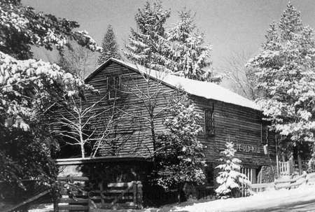
Maxwell’s Mill
Nearby Maxwell’s Bridge where Twyn Rivers Drive does its second bend are the ruins of a grist mill named “Maxwell’s Mill”. The site was built by a James Maxwell in the 1800s. In 1923, Maxwell sold it to Clarence Purcell who used it to raise livestock on his Twyn Waters ranch.


The mill closed in 1929 after a flood weakened it and a fire in the 1970s destroyed much of what remained. Some of the foundations and walls still stand today. An image of Maxwell’s Mill is available on the Scarborough Historical Society’s website.


The Rouge Valley Inn & Caper Valley Ski Hill
The Rouge Valley Inn (later called the Rouge Valley Olympic Inn) was located on the south side of Twyn Rivers Drive slightly before the Scarborough-Pickering Townline. The site was a major Scarborough attraction in the twentieth century with a hotel, dining, picnicking for families, and “the largest swimming pool in Ontario.” Ambrose Small, the 20th century Ontario theatre titan who mysteriously disappeared in 1919, owned the Rouge Valley Inn for a time starting around 1900.


Across the Little Rouge Creek from the Rouge Valley Inn was the Caper Valley Ski Slope, also known as ‘Snake Hill’ for those who used to frequent it. Along with Earl Bales Park and other establishments, it was one of a handful of areas in Metro Toronto that offered the winter passtime. It was operated by Repac, whose name spelled backwards gave the ski hill its moniker. A footbridge linked the inn and the ski slope.


Twyn Rivers Transformed
By the end of the 1970s, much of the historic landmarks of Twyn Rivers Drive disappeared from its geography. Fire claimed both the Rouge Valley Inn in 1968 and Maxwell’s Mill in 1970. The former site of the hotel is now the parking lot for the Twyn Rivers Rouge Park area. The mill’s ruins make for an interesting place for urban explores. Clarence Purcell sold his Twyn Waters ranch to the Metro Toronto and Region Conservation Authority in 1970, which after Hurricane Hazel in 1954 began to buy other valley and ravine properties for parkland. Today, there are very few residences located in Rouge Valley.

By 1973, the Caper Valley Ski Hill was reporting financial difficulty and it too closed by the end of the decade. It now makes for challenging hike in Rouge Park’s Mast Trail. Finally, the Glen Eagles Hotel was also destroyed by fire in 1990, and is now the Glen Eagles Vista park. The site was nearly made condos. Today, most of these are owned and/or managed by Parks Canada.


Twyn Rivers Today
Today, Twyn Rivers is quite the nexus for Rouge National Urban Park, being the starting and ending point of multiple trails. The first source of exploration can be enjoyed around the Rouge Park parking lot. The area is situated on the Little Rouge Creek where the foundations of a former dam still stand. A makeshift footbridge crosses the creek where one can walk in the lost tracks of skiers on Snake Hill.


The Orchard Trail
Near Maxwell’s Mill is the southern terminus of the Orchard Trail. The two-kilometre walk slinks within the forest where apple trees grow today. It also offers vistas of the Little Rouge Creek. A particularly stunning area is the ascent/descent near the north end of the trail.


References
clay70, et al. Purcell’s Mill – Twyn Rivers. www.ontarioabandonedplaces.com/Purcell’s-Mill—Twyn-Rivers-abandoned-Ontario_loc5901.html.
Hikingthegta. “Maxwell’s Mill – Rouge Park.” Hiking the GTA, 24 Nov. 2016, hikingthegta.com/2016/11/23/maxwells-mill-rouge-park/.
Noonan, Larry. “STORIES FROM ROUGE PARK: Hurricane Hazel Also Blasted Rouge Valley.” Toronto.com, Toronto.com, 7 June 2016, www.toronto.com/news-story/6709710-stories-from-rouge-park-hurricane-hazel-also-blasted-rouge-valley/.
Noonan, Larry. “STORIES FROM ROUGE PARK: Recalling the Time the Glen Eagles Lands Were Saved from Condo Developers.” Toronto.com, Toronto.com, 4 June 2015, www.toronto.com/news-story/5661631-stories-from-rouge-park-recalling-the-time-the-glen-eagles-lands-were-saved-from-condo-developers/.
Noonan, Larry. “STORIES FROM ROUGE PARK: Rouge Valley Inn’s Owner Was the Subject of Canada’s Largest Manhunt.” Toronto.com, Toronto.com, 2 July 2015, www.toronto.com/news-story/5705937-stories-from-rouge-park-rouge-valley-inn-s-owner-was-the-subject-of-canada-s-largest-manhunt/.
Noonan, Larry. “STORIES FROM ROUGE PARK: The Ruins of Maxwell’s Mill Can Still Be Seen While Driving along Twyn Rivers Drive in Scarborough.” Toronto.com, Toronto.com, 31 Dec. 2015, www.toronto.com/news-story/6214521-stories-from-rouge-park-the-ruins-of-maxwell-s-mill-can-still-be-seen-while-driving-along-twyn-rivers-drive-in-scarborough/.
Parks Canada Agency, Government of Canada. “Twyn Rivers Area.” Twyn Rivers Area – Rouge National Urban Park, 12 Apr. 2019, www.pc.gc.ca/en/pn-np/on/rouge/culture/histoire-history/twyn.
“Pickering Bygone Days.” DurhamRegion.com, 5 May 2015, www.durhamregion.com/community-story/5600442-pickering-bygone-days/.
Scarborough Historical Society, scarboroughhistorical.ca/local-history/communities/hillside/.
“Toronto’s Ravines and Urban Forests.” Google Books, Google, books.google.ca/books?id=2Q37CAAAQBAJ.
“Who Should Use This 100-Year-Old Scarborough Road? Not Trucks, Says Resident | CBC News.” CBCnews, CBC/Radio Canada, 19 July 2017, www.cbc.ca/news/canada/toronto/twyn-rivers-drive-what-should-happen-1.4212333.
Discover more from Scenes From Toronto
Subscribe to get the latest posts sent to your email.
I am looking for any of the Griffin family that managed The Rouge Valley Inn in the late 1940’s to late 1950’s
Loved the great history of my favorite place Twyn River Dr, its a place like heavens on earth, beautiful.
Sadly a large lack of research regarding the steel truss bridge on Twin Rivers..in an other wise great article I enjoyed greatly
The exact date / age of that bridge can likely be easily referenced..
it would have been built sometime not long after October 1954…it replaced the previous bridge that was destroyed by Hurricane Hazel
if one goes to the triangular area between the corner of the bridge , the guard rail and the corner of the cliff you can still see the concrete remains of that bridge
they have looked exactly as they do , broken and tipped over for the almost 60 years I’m famular with them
on both the opposite side of the road and river ,there is an old house foundation slab with a cement patch in the center that someone wrote in with their finger..says”new valve 1953″..
oddly in front of it there is an old water main poking up from the ground with a flange that would easily mount a fire hydrant
Hi Robert! Thanks for reading. I’m glad you liked the rest of the article, even if the research was incomplete on the bridge. For the record, there’s a lot I could have covered, for example I think there was more to the Ambrose Small connection.
For what it’s worth, the dating of the bridge wasn’t as ‘easy’ for me as there was no materials I could locate that might have alluded what you’ve shared…and I did not consider walking around the bridge. Thank you for the info though — wonderful stuff! Part of doing these articles is people sharing their knowledge and memories 🙂 – Bob
ah ,yeah , I grew up at the top of the hill.. they used to take the local public school kids for tours of the area in a school bus .. so we saw the local landmarks as a “field trip”when we were in “that” grade
the route down the west side hill at the Glen Eagles changed in 1958 ..if you look at an enlarged version of your ’53/’75 pics you can see the old route from halfway down the hill ..it’s slightly obscured by the green line ..and you can also see the foot path between the elbows in the road
and the rows of dots in the field directly above the road at the bottom of the hill .. were pear trees .. they were small but delicious.. as were the apples from the orchard up top of the hill across the road from the glen Eagles Hotel
the mill burned down sometime between 69-72 I can’t say off hand .. but it was barn red when last I saw it .. leaving for the cottage one weekend .. coming home it was gone.. and missed ever since
as is the beautiful orchard property across from the glen eagles .. that the city abandoned doing the maintenance on when the “natural park”propaganda began
it was ..possibly THE nicest piece of parkland at the time in the city
if you google aerial photos city of Toronto 1947-93 you have a wonderful resource at hand
to see what swells rd /reaser road and steels ave used to look like is ..a surprise too
at the corner of the property opposite the Glen Eagles , on the hill overlooking the road going down the hill there were two small steel hydro towers ..
maybe 50 feet tall
they appeared long out of use at the end of the ’60’s and were removed in in the early 70’s
the aerial photos show no sign of them or where the line would have lead but they would have held power lines running into the valley somehow
I used to dance outdoors on Sunday afternoon at a place adjacent to the Rouge River. It was basically a large cement floor. Kids from all over the east end who had access to a car could not wait to get there. The river was dammed with a small bridge to cross the river but I for one found this spot too muddy to swim in. Nevertheless, we were all teenagers having a great time. It was the late fifties. Kids really danced in those days.