The York-Durham Heritage Railway (YDHR) was established in 1987, but as its name suggests, the history stretches beyond. Making use of a discontinued rail line between Uxbridge and Stouffville, the entirely volunteer-run organization offers seasonal weekend train rides between the towns.
The YDHR operates out of Uxbridge, using its 1904 train station as a tiny railway heritage museum. The structure is distinct for its ‘witch’s hat’ roof. At one time its waiting rooms drew would-be rail travelers. Today, the station houses railway artefacts inside and an impressive stock of engines and cars outside. Of note is a passenger car of the Ontario Northlander.
The selection of Uxbridge as the YDHR’s headquarters is appropriate as the Toronto & Nippissing (T&N) Railway housed their main yards there. The T&N Railway established the rail line in the 1860s. George Gooderham was a main investor who used the line to bring raw materials from Ontario’s northern reaches to the Gooderham & Worts complex on the Toronto waterfront. In 1871, a ceremony opened the line in Uxbridge.
Map of the Township of Uxbridge, 1877. The Township was once part of Ontario County which merged with other local counties to create the Regional Municipality of Durham. Source: Canadian County Altas Digital Project.Gooderham & Worts, Ltd., Toronto., 1896. Source: Toronto Public Library.
Uxbridge itself is a suburban town which retains its 19th charm. It is perhaps most famed for the mausoleum of Thomas Foster, a Toronto mayor from 1925-1927, which was inspired by a trip to India.
The YHDR’s main train is the 1956 Locomotive 3612, complete with dining and bench seating passanger cars for a relaxing trip and an open-window snack/baggage car for a more scenic opportunities.
The Fall Colours Train showcases the diverse landscapes of forests, farm fields, golf courses, and gravel pits of the Oak Ridges Moraine (ORM), an environmentally protected and sensitive corridor north of Toronto between Caledon and Peterborough. Elevation in ORM reaches as high as the CN Tower.
The Town of Goodwood is the mid-way point of the trip. At one time the T&N Railway served it; its station now replaced with GO bus transit. Interestingly, Goodwood doubles as the TV town of Schitt’s Creek. Just south and west in Licolnville, the train crosses into York Region.
Stouffville too is a train town. While the current GO station dates to 1995, the arrival of the Toronto & Nippising Railway brought the first station on south of Main Street to the town. It in turn spurred commercial and industrial development.
A brief history includes town founder Abraham Stouffer settling here in 1804, naming the hamlet “Stoufferville”, which was later shortened. Along with the Toronto & Nipissing Railway, there was also the Lake Simcoe Railway running to Sutton, Ontario, making Stouffville into a railway junction.
Map of the Township of Whitchurch, 1878. Note the lands around Stouffville belonging to the Stouffer family. Source: The County Atlas Digital Project.
After financial difficulties which saw the T&N railway transferring between rail companies, the Canadian National Railway eventually came to own the line in 1920. Northerly sections of track fell out of use gradually through the 20th century. Today, the original T&N right of way transports passengers through the Stouffville Go Line, passing through stations at Markham, Unionville, Agincourt, and Scarborough. Whereas a small station in the Distillery District once served as the the southern terminus, Union Station expectedly takes that spot today. The York-Durham Heritage Railway began operations in 1996. Metrolinx still owns the YDHR track and is considering returning service to Uxbridge.
What presumably started as pristine wilderness for many Indigenous peoples, the area that came to be Kensington Market began to take shape under the 1793 colonial park lot system established and administered by John Graves Simcoe and his successors. Here, plots 17 & 18 passed through several owners, eventually falling to Denison family. While today we associate the block between College & Dundas Streets and Spadina Avenue & Bathurst Street with a dense mix of narrow streets and an unlikely mishmash of altered structures, the only built form in the first part of 19th century was the Denisons’ Georgian manor, Belle Vue (also spelt Bellevue).
1842 Cane Topographical Plan of the City and Liberties of Toronto. Credit: Old Toronto Maps.Denison, George Taylor, ‘Bellevue’, Denison Sq., n. side, e. of Bellevue Ave. 1912. Credit: Toronto Public Library.
Lost in the modern geography of Kensington Market is the waterway and pond situated just above Belle Vue. Named for a rather unpleasant character in Toronto history, Russell Creek passed through the southern half of the block towards today’s Entertainment District before flowing into the old shore of Lake Ontario near Front & Simcoe Streets.
1862 HJ Browne Plan of the City of Toronto. Credit: Old Toronto Maps.
In the mid-1800s, the Belle Vue Estate was subdivided and town lots were put up for sale. Several marketing pieces at the time advertised the lots for sale. Notably, an 1854 pitch highlighted their location in “the most healthy and pleasant part of the city” at a great elevation from Lake Ontario. It also promoted the great proximity to the new Ontario Legislative Buildings and Government House, which as far as I know might have been proposed but were certainly never built (the current legislature opened in 1893).
1854 Plan of part of the city of Toronto showing the town lots on Bellevue for sale by the trustees for the Denison Estate March 1854. Credit: Toronto Public Library.1869 Plan of building lots on part of the Belle Vue estate in the City of Toronto, the property of J. Saurin McMurray, Esq.. Credit: Toronto Public Libary.
To make way for the residential neighbourhood, Russell Creek and its pond were buried in 1876, following a trend with other creeks in Toronto. Today, there is little trace of its existence. Compared to Garrison and Taddle Creeks though, Russell Creek seems to sit lower in the psyche and awareness of Torontonians as it is not as readily mentioned. Belle Vue would last for a few more decades, disappearing by 1890. Strangely, it seems to shows up in the Goads fire insurance maps as late as 1903, however. It was replaced by houses and then finally the Kiever Synagogue in 1927.
Although the house is gone, Belle Vue’s geographic imprint remains in a few locales. Bellevue Square, which historically served as the promenade grounds for the manor, was donated to the city as public space in 1887. Denison Avenue was the driveway to the grounds. The names of the streets themselves offer links to the Denison Estate and the English motherland in general with monikers such as Lippincott Street, Bellevue Avenue, Oxford Street, and of course, Kensington Street. The latter is a throwback to the London commercial district of the same name (it is not clear who in Toronto drew the connection and offered the designation, though).
1889 Insurance Plan of the City of Toronto. Belle Vue House, while now housing an address at 22 Denison Square, is positioned with its corners aligning with the directions of a compass. By the end of the century, one can see the modern roots of Kensington Market’s layout of narrow streets and closely bunched structures. Credit: Old Toronto Maps
Of course, there is also the Victorian housing stock whose architectural style by definition is referential to the reigning monarch at the time. The early occupants of the neighbourhoood were unsuprisingly of largely White Anglo-Saxon Protestant descent. What happened to some of these houses over the next few generations erased that early connection to Britain, however.
Around the turn of the 20th century, the WASPs migrated to more favourable parts of Toronto. Finding opportunity and low rents, the Jewish community already situated in The Ward moved into those empty houses. It’s a common story to Toronto: a group occupies a space, leaves after it outlives its utility, and then a new group moves in and remakes it accordingly.
These East European Jews settled on Kensington, Augusta, and Baldwin Streets, not only residing in the former homes of their white predecessors, but also altering their fronts to accommodate commercial enterprise. And so began the ‘Jewish Market’. This ‘creation and re-creation’ happened over and over in Kensington Market. The Jews’ out-migration around World War II left their storefronts to other populations of Italian, Portuguese, Caribbean, and South & East Asian entrepreneurs, allowing new histories to be created.
The former Sanci’s fruit shop was the first non-Jewish merchant in Kensington Market. There’s a cross in the brickwork atop the store hinting at the building’s roots.Baldwin Street, 1940s. Credit: Library & Archives Canada.
The importance of Kensington Market in the lives of generations of Canadian immigrants led to its designation as a place of national significance and as a National Historic Site in 2006. In 2017, Historica Canada neatly and creatively distilled its layered history into its first animated Heritage Minute. The clip nicely showcases the physical and cultural transformation of a shop through the decades, moving from the outside to the inside and back out again to show the masses of people who have frequented the Market through the ages.
The grand narrative of Kensington Market has then been this intersection between tangible (geographic) and intangible (cultural). That is to say, the histories of the people within the same physical space they have all come to call “home” over the years. Many writers have explored the theme, including Na Li in her book Kensington Market: Collective Memory, Public History, and Toronto’s Urban Landscape. The original Victorian homes, dramatically altered they after generations of use and reuse, become vessels to tell these stories.
From the Baldwin family countryside to the cafe- and bar-filled nexus of today, Kensington Market’s evolution was unplanned, organic, and anarchic, and yet somehow still falling in line with what came before. It survived urban renewal plans in the 1960s whose purpose to preserve the neighbourhood would have actually destroyed it. The quirks in its murals, hidden backways, street sights, and people can only exist within its borders. It cannot be replicated.
1889 Insurance Plan of the City of Toronto showing Kensington Place and Fitroy Terrace as part of the initial layout of the subdivided neighbourhood. Credit: Old Toronto Maps
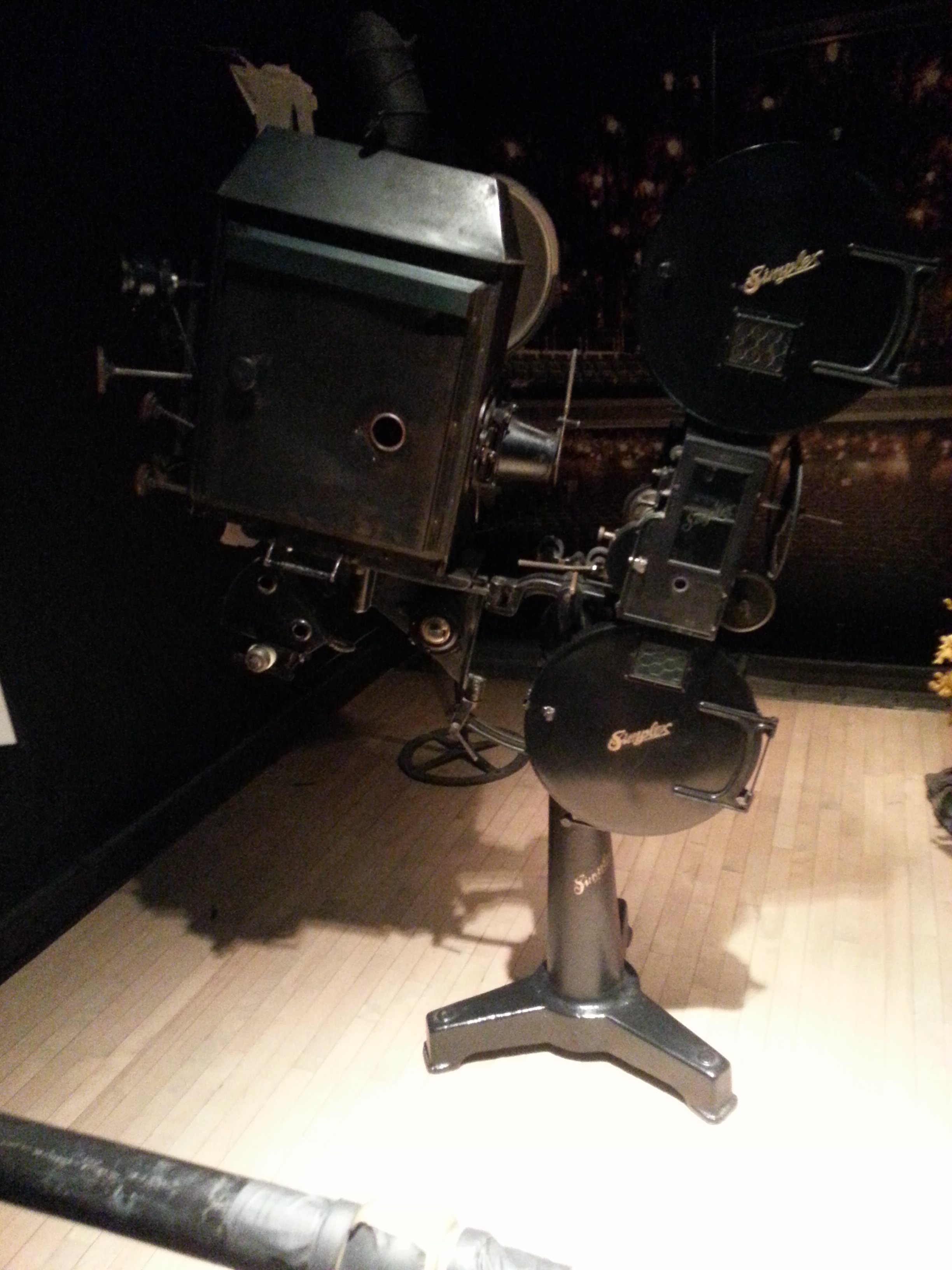
The Elgin and Winter Garden Theatre Centre is a very intriguing Toronto landmark. In addition to being perhaps the only double-decker theatre left on the continent, it is also a National Historic Site (NHS) as of 1982, making it a cultural icon on a national level. Beyond its significance as a modern performing arts centre and a movie house before that, it houses the greatest collection of 1920s Vaudeville props and sets.
Photo Credit: Ontario Heritage Trust
Unlike most National Historic Sites which have undergone adaptive reuse as museums (Fort York) or commercial establishments (The Distillery District), the Elgin and Winter Garden continues to be a fully functional, money making enterprise. This presents an interesting situation because as a NHS it must protect, promote, and manage the heritage values – while also existing as a living venue whose primary goal is to put on productions and attract paying visitors.
Corridor leading from the main doorsThe Grand Staircase
The Centre was designed with allure of grandeur. The ornamental gold on the walls and the marble columns are just that – finishes. Being at the Centre is as much about witnessing a spectacle inside the theatres themselves as much as it outside of them.
Managing the heritage aspects of the theatres while trying to keep it operational I learned is a tough task if only because one encounters heritage everywhere. I found out that it is about finding a middle ground, a compromise – being the least invasive. Often this involves creative solutions to issues.
The Elgin TheatreThe Winter Garden Theatre
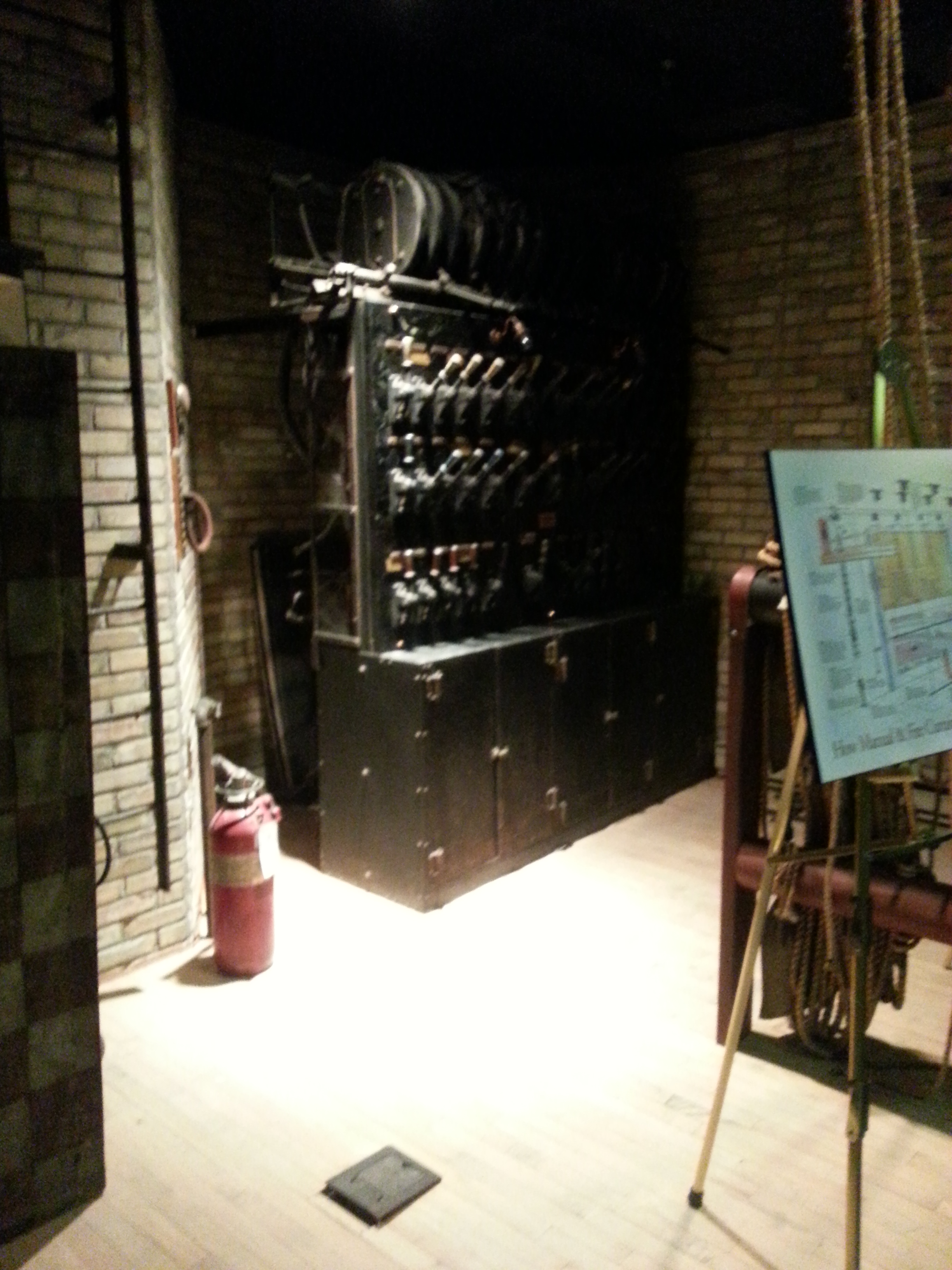
The Winter Garden Theatre was closed in 1928, which left it in a time capsule until the Ontario Heritage Trust rescued and restored both theatres in 1981. The walls, which had taken 50 years of dirt, had to be cleaned with bread dough so as to not disturb the designs underneath. The leaves hanging from the ceiling (barely visible in the darkened picture) had to be made fire proof because they are otherwise a hazard.
Perhaps the most famous production in the Centre’s historyModel of the Theatre
The theatres have museum-like elements with a number of exhibits including the original camera and electrical panel backstage and information on the famed shows (including the wildly successful “Cats”) that have graced its stages. Notable is a detailed model of the entire complex. It’s fun to note that the theatres themselves were built to front onto Victoria Street because real estate was more highly priced on Yonge Street (like it is today). With the 100th anniversary of the Elgin Theatre this year, there have been more opportunities to showcase its animated history.
Special thanks to The Architectural Conservancy of Ontario‘s Next Gen group for allowing this inside look. They allowed me pleasure of shadowing the General Manager, Brett Randall, as well as some of his staff at the Elgin and Winter Garden Theatre National Historic Site. The multi-perspective insight on how to run a heritage site and a performing arts venue was a treat.
Once the home of working class Irish immigrants, walking the storied streets of Corktown one can see a showcase of the old, the new, and old and new side by side. Long past its days of being a working class neighbourhood, Corktown, like its sister neighbourhood Cabbagetown to the north, has become a gentrified hotbed just outside of the downtown core.
Corktown’s street layout has been reconfigured over the years to account for several changes in the neighbourhood. The razing of the House of Providence south of St. Paul’s Basilica allowed for the extensions of Adelaide and Richmond (which were Duchess and Duke, respectively) toward the Don Valley Parkway in the 1960s. In more recent activity, River Street was extended south of King Street for the Don Lands development.
Walking the streets of Corktown, I could trace the various aspects of life a resident would have encountered: the residential 19th century rowhouses on Trinity and Percy streets, the markets and factories on King Street, the religious institutions of Little Trinity Church and St. Paul’s Basilica, to the educational institutions like the Enoch Turner Schoolhouse and Inglenook (Sackville Street) School. It made it an experience to walk those steps.
And in the same sense, I could look forward into the future of the neighbourhood. Condo buildings erecting on King Street and the rippling effects of the nearby construction of the West Don Lands community and aptly named Corktown Commons parkland tells me of a neighbourhood going through some changes.


