‘Millions Put in New Buildings: Toronto’s Growing Business Must be Accommodated’ – The Globe: March 19, 1907

While digging up some info on a separate topic (expectedly, a look into a former factory in Toronto’s east end), I came across an interesting article in the March 19, 1907 edition of The Globe. It speaks to the growth of Toronto’s built character in that year. It makes reference to many prominent buildings in the story of Toronto then under construction – some still with us, some not.

MillionsPutInNewBuildings0

MillionsPutInNewBuildings1

What fascinated me most is that the article speaks directly to the economic, industrial, and commercial expansion of Toronto in the early 20th century. It’s my theory that this period – that is, the Edwardian era through to the interwar years – was massively transformative on a number of levels – social, economic, and political –  and maybe the most crucial period in the city’s history.

Just off the top of my head, one sees the annexation of numerous communities into the grand City of Toronto, the introduction of the automobile, the emergence of Toronto Hydro, the prominence of neighbourhood theatres (and, with that, vaudeville theatre), and, through my own research into Toronto’s industrial history, the erection of countless manufacturing establishments. Such a topic – the expansion of Toronto from 19oo to 1930 (or, pushing it more, 1940) – I believe is deserving of a book or, at least, a scholarly paper. Perhaps I should take this up.

To get a better sense of the locations in the piece, I referred to the ever resourceful Toronto Historic Maps site.

MillionsPutInNewBuildings2
Striking here is the author’s suggestion that the number of building projects underway is unprecedented – upwards of 3 million dollars. There was a push to rebuild Toronto after the Great Fire of 1904, but looks as though in 1907, the expansion was far more accelerated.

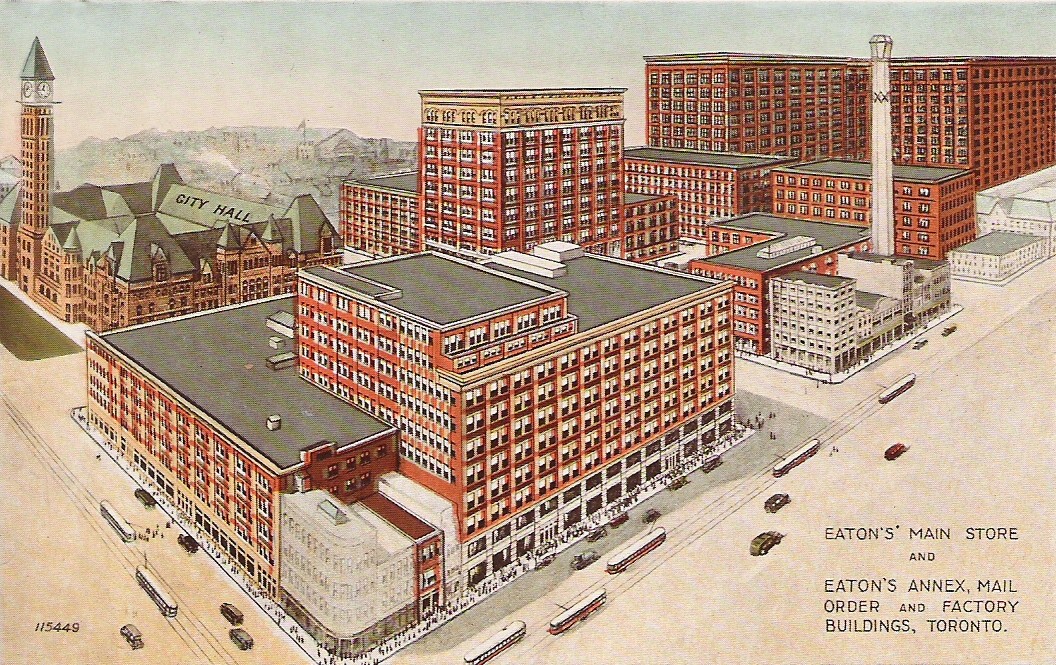
There’s, of course reference, to Eaton’s and Simpson’s, both manufacturing and commercial juggernauts in Toronto at one time. The former’s holdings at what is largely now the Eaton Centre has been completely wiped out, including the mentioned factory at Yonge and Albert. It’s an intersection that no longer exists either! For the expanding Robert Simpson Co., the writer talks about James Street upcoming extension to Richmond, which did indeed happen according to the 1913 Goad’s, but it’s now  back to its original terminus.

MillionsPutInNewBuildings3

Familiar to me are the Christie, Brown & Co. factory (now George Brown College) and the Queen City Vinegar Co. (now lofts). Both impressive structures. Also, Riverdale and Leslieville experienced quite a bit of growth in the early century, and that’s reflected here.

MillionsPutInNewBuildings4

Aside from the Canada Foundry Co., located up at Lansdowne between Davenport and Dupont, many of these look to be in what is now the Entertainment District. I’m surprised there’s no reference to the Massey-Harris plants as they surely expanded in this period.

MillionsPutInNewBuildings51

MillionsPutInNewBuildings52I don’t know if that 20-storey office was ever built. And where this Monarch Bank is/was. I do like the early adaptive re-use though, even if a store to a bank isn’t the hugest stretch!

MillionsPutInNewBuildings6A couple of E.J. Lennox properties appear in the King Edward Hotel and the Victoria Orange Hall at Queen and Bond, a grand building which stood as a testament to Protestant Toronto. Nearby, Mr. Shea’s theatre was the aptly named Shea at Victoria and Richmond, now lost. The new theatre on King Street West is undoubtedly the Royal Alexandra. The very final point refers to Lol Solman, the man behind Hanlan’s Point Amusement Park.

Scenes From South Rosedale and Ravines

It’s not often I go on my psychogeographic walks in the company of others. Alas, this is my situation – the second time in as many weekends – that I find myself in.

As a resolution to myself, I’ve decided to expand my social network – put myself ‘out there’, so to speak. And so here I find myself: Standing in front of Sherbourne Subway Station along with 30+ strangers to go to a Meetup walk through South Rosedale and its connecting trails.

1. Rosedale

A quick stroll up the street and we find ourselves – at the direction of the Meetup organizer – winding around Rosedale’s streets, which themselves do some winding. Yes, the layout of this upscale neighbourhood bites its thumb to Toronto’s grid(ish) setup. It was designed as an enclave after all and still has that character. It’s easy to feel like an outsider – a tourist, of sorts – while marveling at its (Edwardian, Victorian and otherwise) houses.

2. Rosedale

3. Rosedale

Our path roughly follows Park Drive, Maple Avenue, Glen Road, Dale Avenue, and Castle Frank Road. The naming of (at least some of) Rosedale’s streets follows a very nature-filled theme: Maple and Elm are, of course, types of trees; and, Dale and Glen both mean ‘valley’. Yes, this is an enclave defined by its flora and its geographic contours as much as it is its built heritage.

6. Rosedale        7. Rosedale

8. Rosedale

Passing through Cragleigh Gardens, the former estate turned public park, we round a corner and begin our descent via Milkman’s Lane. A certain coolness greets us at the bottom…along with a happy go lucky doggy who’s decided that playing in a mud puddle is a fun exercise. His owners aren’t part of our group, and I don’t suppose they figure it fun for them!

9. Milkman's Lane

Further up the way, I note some pillars off to the side. They look like gates. Gates to what? I don’t know. If any trail/local history enthusiasts want to lend their knowledge, I’d be curious to know!

EDIT: Hiking The GTA points out that the stone pillars likely led up to 4A Beaumont. Neat

10. Park Drive Reservation Trail

Park Drive Reservation Trail hugs Yellow Creek. It’s definitely how you would picture a creek: Shallow, not so potent. It enters a sewer in at least one spot. Someone near to me asks if it’s a water treatment plant. I say I think it’s too small for that. We’ve got huge one in the east end for that. Then we get into a discussion of the RC Harris Plant. She thinks it was a prison. I say water infrastructure can look that awesome.

11. Park Drive Reservation Trail Yellow Creek

12. Park Drive Reservation Trail

13. Park Drive Reservation Trail CPR Bridge

The trail ends at Mount Pleasant Road. There’s a moment where we contemplate jaywalking. Alas, we do, after the rush of cars ends. It’s an intersection perhaps in need of traffic lights, I’d think.

Our Meetup continues on the Belt Line Trail. This one is a bit more uneven in its terrain. I look up and see houses overlooking the valley. That’s quite a backyard to have.

15. Beltline Trail      17. Beltline Trail Yellow Creek

18. David Balfour Park Trail

At one point a fellow walker asks me where we are. I answer in earnest that I do not know. I know our destination, but deep in the valley my bearings are a bit off. There’s an incline – the biggest of the whole trail.

19. David Balfour Park Trail

At the end of it, we’re back to civilization. Taking a look around, I know where we are. Avoca Avenue! I recognize the railings beside us and the story behind them from a Heritage Toronto walk of Deer Park. They were originally on the Avoca Bridge – the predecessor to the St. Clair viaduct.

From there, we head south to David Balfour Rosehill Reservoir Park, making a circle around it. The reservoir was covered in the 40s, but a H20 molecule marks the park’s history.

20. Rosehill Reservoir

21. Rosehill Reservoir

On St.Clair now, it’s to the subway (or post-Meetup libations for some) we go. Before that though, there’s the Arthur Meighen Federal Building to note. It’s a 1957 construction, but there’s some definite Art Deco influence in its ornamentation.

22. Arthur Meighen Building
Related Links

Hiking The GTA – Milkman’s Lane

Jane’s Walk 2015 Roundup

Day 1: Friday May 1, 2015

The City’s Best Hiding Places: A Geocaching Tour!
Walk Leader: Denise Pinto
4pm

I liked this walk because it reintroduced me into a hobby I took up a few summers ago…and then inexplicably dropped. Geocaching is basically a treasure hunt involving GPSs and storytelling.

Denise Pinto, the very awesome global head of Jane’s Walk, led us around her own neighbourhood south of the Danforth around Donlands and Greenwood. It’s a neat area full of parks connected with corridors of green space. Looking at old maps, some of those parks are the remnants of a buried creek. Who knew?

And actually, that feeds into the point of geocaching: One hides a cache in order to bring someone to a place that is special to him and wants people to know. It’s about sharing stories and experience. Denise hid caches along the way and had us find them.

Among our route, we passed a playground, a community garden, and a lookout for the Greenwood Subway Yard. As a bonus, it ended at the Allenby.

Jane's Walk 2015 Geocaching (1)

Jane's Walk 2015 Geocaching (2)

Jane's Walk 2015 Geocaching (3)

Jane's Walk 2015 Geocaching (4)

Day 2: Saturday May 2, 2o15

To demolish, or not to demolish? Exploring Heritage Character in Toronto’s Downtown
Walk Leader: Michael Matthys
11am

This one was about the layers of history, heritage preservation, and how we make use of historic buildings that live past their original uses. Michael Matthys, a planner by trade with DIALOG, took us through the Downtown Yonge Street neighbourhood and showed us examples – good and bad and controversial – of sustainable adaption of modern buildings.

75 St. Nicholas Street, for example, is a condo development that utilizes an old planing mill as its base.  The problem – and it is one in many people’s eyes – is that the factory is no more than a facade. The mill was dissassembled, rebuilt brick by brick, and incorporated into the condo. Michael raises the question on whether this kind of preservation makes sense. What heritage is preserved? What’s the economic benefit from it?

Another case comes with 5 St. Joseph, which like 75 St. Nicholas, reuses a light industrial space – the old M. Rawlinson factory. Also like 75 St. Nicholas, planning got into the discussion. Are condos what we want? The city is growing; people need to live somewhere. It’s hard to strike a balance. It’s how we – citizens, government, developers – go about it. A nice bonus of going on Jane’s Walks, you get unexpected perspectives: while talking about this development, a resident of the building across the street told us that tower blocks sunlight to it.

After passing through the infamous site of the floating Irwin house development, the walk ended with a stop at Maple Leaf Gardens, which is a great example of a transformed space that pays tribute to its original use. The Gardens is one of two remaining Original Six arenas, and out of the two is the better preserved and utilized. The Mattamy Centre, the home of the Ryerson Rams, on the top floor is great because once again MLG is used for its original purpose.

Jane's Walk 2015 Heritage Character of Downtown Toronto (2)

Jane's Walk 2015 Heritage Character of Downtown Toronto (4)     Jane's Walk 2015 Heritage Character of Downtown Toronto (5)

Jane's Walk 2015 Heritage Character of Downtown Toronto (6)

Jane's Walk 2015 Heritage Character of Downtown Toronto (7)

Building Bloor: Alec Keefer with the Rosina Shopkeeper Project
Walk Organizer: Alec Keefer
3pm

This was the most attended walk of my weekend, and there was good and bad that came with that. It was the first of two walks this weekend on the Rosina Shopkeeper Project, a great grassroots effort to tell the stories of the tenants and entrepreneurs of Bloor Street.

The leader – local historian and former president of the Toronto Architectural Conservancy – Alec Keefer, is a library on all things old Toronto. His insights into the architecture, the construction, and function of the structures of Bloor Street West is remarkable.  He explains the start of Bloor Street as a residential street of 1910s Edwardian homes which were then often fitted with an addition to support commercial space. He points out details about the face of structures like the important of cap roofs – many of which are now gone – and fire walls separating units.

The flip side to huge turnout on a great topic: it’s hard to take in everything. I lost out on a lot of stories just because I could not hear. Also, it can be a task to travel down Bloor on a beautiful Saturday afternoon; it is definitely a challenge to meander its narrow sidewalks with over 100 other people.

The one tidbit I do recall is on the Black Horse pub. It had an ornamental horse on the front of the building, which suggests that the original occupants might have been saddlers and worked with leather.

As a side note, this walk was also memorable because I had my first interaction with a fellow blogger in the real world. Shoutout to Mary (notcontary) for the chance encounter!

Jane's Walk 2015 Building Bloor (1)

Jane's Walk 2015 Building Bloor (2)

Jane's Walk 2015 Building Bloor (3)

Jane's Walk 2015 Building Bloor (4)

Jane's Walk 2015 Building Bloor (5)

Day 3: SUNDAY May 3, 2o15

Intriguing, industrial, Sterling Road!!
Walk Leader: Catto Houghton
1pm

I not only attended this tour, but as a volunteer for Jane’s Walk, I wanted to help out on this walk. So I did. It’s a street loaded with industrial history and one in huge transition. How could I not be part of that?

Led by artist Catto Houghton, who has connections to Sterling and the Junction & Junction Triangle areas, it’s a street that has a ton of hidden history – and a hidden reality to most Torontonians today.

The whole time I mentally equated it as the Carlaw Avenue of the west side.  Factories started popping up on both streets in the 1900s and 1910s, relied heavily on the surrounding railroads, reached a heyday in the mid part of the century, and then closed and subsequently either demolished or vacant until purposing in the latter part. It seems that Carlaw is nearing the end of its shift, but Sterling has a bit to go.

The east side of the street immediately north of Dundas is a parking lot, but that was populated with factories way back when. The lot now services Nestle, the great complex that hugs both sides of the street. Nestle is latest incarnation of a lineage of chocolate making enterprises on Sterling dating back at least 100 years, starting with Cowan Cocoa and Chocolate. Cowan went under 1926 and was taken over by Rowntree’s, which created to first chocolate bar. Finally, Nestle bought Rowntree’s in 1988. The original Cowan building is still part of its facility. Catto, part of her great research, brought out some great ephemeralia of these companies.

The Tower Automotive building is an intriguing case. It’s a landmark on the street, but not looking so good now. There was plans to rezone the street to allow mixed use development, including repurposing the tower into lofts. Our friends Nestle fought hard against this because having residents as neighbours is not in their interests. I’ve seen it before in the Weston’s factory I worked in. Operating in a residential neighbourhood leads to noise complaints lead to buckling to pressure. Those plans are on hold and it’s definitely a case to watch.

The walk was unlike others in that in Catto arranged interior tours. Like Carlaw’s Creative Lofts, Sterling has a few complexes of live-work space where artists and entrepreneurs set up shop. The street is also home to an axe throwing league and a circus school. But you wouldn’t know it.

I’ll definitely have to come back and explore more of the area.

Jane's Walk 2015 Sterling Road (1)

Jane's Walk 2015 Sterling Road (2)

Jane's Walk 2015 Sterling Road (3)

Jane's Walk 2015 Sterling Road (4)

Jane's Walk 2015 Sterling Road (5)

Jane's Walk 2015 Sterling Road (6)

Dark Age Ahead – The Wizard of Ossington Jane’s Walk
Walk Leader: HiMY SYeD
5pm

If I understand HiMY‘s message correctly from this walk, I can summarize everything here, but to truly understand The Wizard of Ossington, you have to attend it, experience it, and share in the conversations and story telling. Still, I’ll do a bit of summarizing and encourage people to check out the next time.

HiMY’s took us through the Christie Pits neighbourhood and picked out visual examples as well as examples from his own experience which help to illustrate Jane Jacob’s last book, The Dark Age Ahead. For a last book, it’s definitely not a pick-me-up. She identifies trends in North American society that if continued might lead to a Dark Age.

One of the themes of the walk is memory and how we remember and forget, and what happens when we, as a collective, forget. Mass amnesia is what Jane calls it and it’s the result of a decaying society.

An example HiMY uses is a Greek temple house. There’s danger in assembling a few artifacts, recreating a Hellenic style temple, and then claiming to have an understanding of Ancient Greek culture. Culture isn’t the physical remnants of a peoples; it’s the day to day interactions and stories that are passed down through oral tradition and language.

Jane's Walk 2015 Dark Age Ahead (1)      Jane's Walk 2015 Dark Age Ahead (2)

Jane's Walk 2015 Dark Age Ahead (3)       Jane's Walk 2015 Dark Age Ahead (4)

Jane's Walk 2015 Dark Age Ahead (5)