Since the train first tracks in the 1850s, Toronto’s railways have been a big part of its geography and history. They connect the city and its surroundings, joining neighbourhoods and people. They were also the driving force of industry. Founded in 2001, the Toronto Railway Museum tells their stories. One finds it across the CN Tower, Rogers Centre, and Ripley’s Aquarium in the appropriately named Roundhouse Park.
Map of Toronto’s Railways, date unknown. Credit: Toronto Public Library.
Operated by the Toronto Railway Historical Association, the Toronto Railway Museum is based in the great John Street Roundhouse and the surrounding Roundhouse Park. The location is appropriate: Toronto’s railway corridor extended east and west of Union Station and was once the nexus of the city’s transportation network. In many ways, it still is.
Union Station Railway Corridor, 1969. Credit: City of Toronto Archives.
The John Street Roundhouse was part of that infrastructure. The structure itself was built by Canadian Pacific Railway between 1929 and 1931 as a maintenance and storage facility and to allow trains to, well, turn around.
As an interpretive experience, Toronto Railway Museum is immersive. It starts with an interior space in the Roundhouse’s Stall 17. There are maps and train memorabilia. There’s even a simulator which allows you to conduct a train around historic Toronto.
Outside, it functions as an open air museum. Well-produced plaques are located around park, often near significant landmarks. There are of course some train cars, some of which allow entry inside.
Most notable to me is the marker about the Workers of John Street. Most of Roundhouse Park’s landmarks highlight something physically awing like the Water Tower or a Canadian National Railway train, but this plaque focuses on the easily forgotten human element behind this tough industry.
Of course, Don Station is a remarkable site too. It is part of Toronto’s lost geography of bygone railway stations, companies, structures, and tracks. It operated 1896 to 1967 at Queen Street and the Don River. Then it spent time at Todmorden Mills until 2008 when it was moved to Roundhouse Park and subsequently restored. It also serves the museum’s gift shop and departure point for the park’s own train rides.
CPR Don Station looking west, 1910. Credit: City of Toronto Archives.Goads Map, 1913. Credit: Old Toronto Maps
John Street Roundhouse closed in 1986. It marked an era where the railways were taking a bit of a backseat in Toronto’s development. Industry within the city was declining as manufacturing moved elsewhere. The physical lands of the railroads shifted too. Tracks were removed and lands — and some remaining sites — were redeveloped for new residential, commecial, and entertainment uses.
Union Station Railway Corridor, 1992. Credit: City of Toronto Archives.
The Corridor just south Union Station saw a lot of this transformation. In 1976, the CN Tower was completed. The 1980s saw opening of the Metro Convention Centre and SkyDome (now Rogers Centre). The latter actually replaced another roundhouse. Using the facade of the old Postal Delivery Building, the Air Canada Centre (now Scotiabank Arena) came in 1999 as the new home of the Toronto Maple Leafs and newly created Toronto Raptors. Since then, a condo community has grown up around it since as well as a fan area called Maple Leaf Square in 2010. Most recently, the area got the impressive Ripleys Aquarium in 2013.
Union Station Railway Corridor, 2019. Credit: Google Maps.
The John Street Roundhouse was designated a National Historic Site in 1990. Its heritage value comes from being the best example of a roundhouse in the country — its turntable actually works! Roundhouse Park opened around it in 1997 to further its legacy. In 1999, the roundhouse’s stalls became home to the aptly-named Steam Whistle Brewery and then Leon’s in 2009 (it closed for the Rec Room two years ago).
In 2019, the John Street Roundhouse celebrates its 90th birthday, making it a good time to reflect on its related history and geography. And stories. Lot of stories.
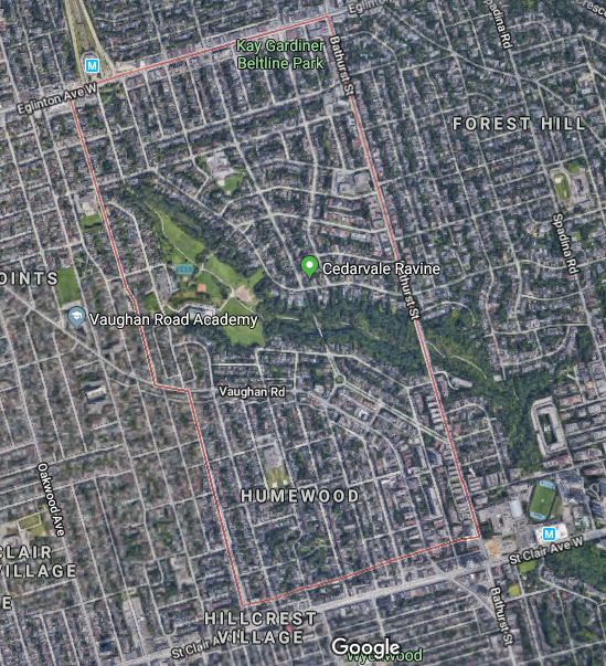
Cedarvale lies northwest of the intersection of Bathurst Street and St. Clair Avenue West in the old City of York. At the centre of its story and its geography is its parkland. All that surrounds is just as interesting.
Cedarvale, 2018. Credit: Google Maps.
Mappy beginnings
The history of Cedarvale begins with lots 26 and 27 of Concession III west of Yonge Street from the old lot system. The third concession road is now the mentioned St. Clair West with the 200-acre lots extending north to the fourth concession (Eglinton Avenue) just west of present Bathurst Street.
Tremaine’s Map of the County of York, Canada West, 1860. Credit: Historical Maps of Toronto.
Lot 27 first appears in Toronto maps as belonging to the Estate of James Brown. It then passed to John Roach. Lot 28 belonged to a John Severn and then to a Mr. Davidson. The 1899 and 1903 editions of the Goads Fire Insurance Maps show brick fields near Markham Street (today’s Raglan Avenue) which are gone by 1910. Flowing diagonally through the plots was Castle Frank Brook, making brick manufacturing a possibility. The stream was also known as Brewery Creek or Severn Creek, as it is the same waterway that aided the Severn Brewery in Yorkville. It is unclear if the brewer and the land owner are the same, but it is notable their given names do match. By the 1910s, the plots appear under the name of Sir Henry Pellatt of Casa Loma fame.
Illustrated Historical Atlas of the County of York, 1878. Roach Street within the modern community (now Strathearn Street) was named for John Roach and falls within his former borders. Credit: Historical Toronto MapsMap of the Townships, York, Scarboro, and Etobicoke, 1916. Credit: University of Toronto Map & Date Library.
A New Subdivision
Situated up Bathurst at Claxton Boulevard is the first curiousity about this unique area: the Connaught Gates. Dating to 1913, they hide an ambitious past.
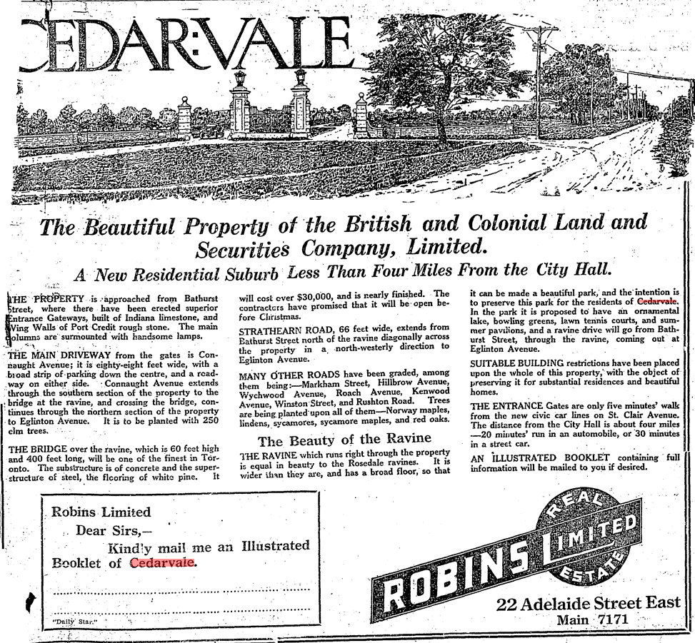
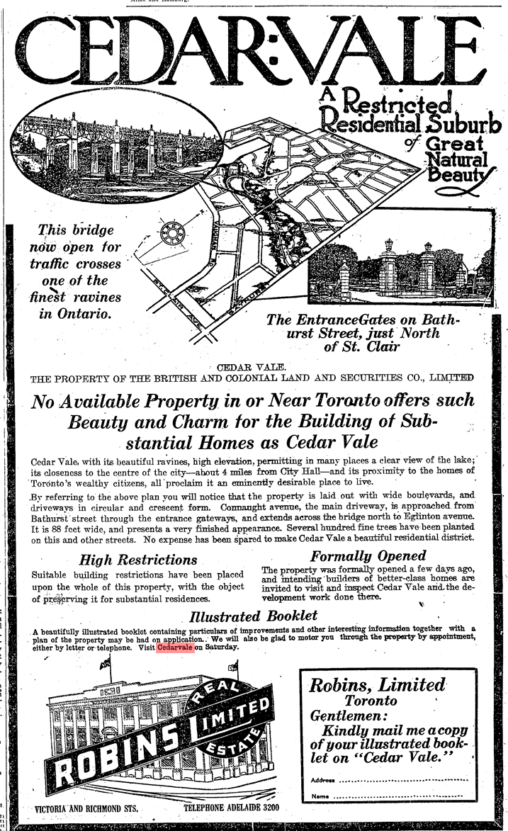
Beginning in June 1912, advertisements in The Toronto Daily Star and The Globe newspapers promoted a new exclusive suburb named Cedarvale (or Cedar Vale) in the area south of Eglinton Avenue, north of Vaughan Road, and west of Bathurst Street. The company behind the new 300-acre subdivision was The British and Colonial Land and Securities Company, which was Sir Henry Pellatt’s realty firm. Pellatt’s interests were in land accumulation and speculation. The sales pieces marketed Cedarvale’s tree-lined streets including a neighbourhood-spanning central boulevard and a natural beauty even surpassing Rosedale in the form of Cedarvale ravine. Interested parties were to contact Robins Real Estate Limited for an illustrated booklet.
Cedarvale ad, Toronto Daily Star November 8, 1912. Credit: Toronto Public LibraryCedarvale ad, The Globe, June 7, 1913. Credit: Toronto Public Library.
Contextually, Cedarvale’s emergence came at a time in the early 20th century when civic discussions revolved heavily around the growth of the city of Toronto and its surrounding areas. Annexations of neighbouring St. Clair Avenue communities of Wychwood and Bracondale in 1909 and Dovercourt and Earlscount in 1910 increased the city’s borders. In the following year, the Toronto Civic Railways opened a transit line along St. Clair, effectively turning those communities into streetcar suburbs and spurring development. Cedarvale – which took advantage of the new streetcar in their new promotional pieces – joined these discussions of annexation, which included a November 1912 meeting of Pellatt, John Gibson, and other investors with Toronto mayor Horatio Hocken. Although the benefits of extending city services like sewers and police and fire protection were discussed, Cedarvale ultimately stayed in the Township of York, not joining Toronto until the mega-city amalgamation in 1998.
“Cedarvale Annexation”, Toronto Daily Star, July 3, 1914. Credit: Source: Toronto Public Library.Map of the township of York, 1923. Credit: Toronto Public Library.
The original vision of Cedarvale centred around Connaught Avenue. From the gates at Bathurst, the street travelled northwest, passing through the Connaught Circle roundabout. It then spanned over the valley with the mighty Connaught Bridge. The bridge was important in connecting the upper and lower parts neighbourhood, an affinity still valued today. From here, Connaught spilt into east and west sections, surrounding a diamond island of gardens, finally terminating at Eglinton. Surrounding streets, including one named Pellatt Crescent, fed into the Connaught Gardens. Ravine Drive followed the valley below with lots for purchase. Running adjacent was a trail as well as a lake and tennis courts which could be accessed from the path or via stairs from Hillbrow and Roach Street (Heathdale and Humewood Street today). They would have been located where the Cricket Field and Phil White Arena stand today.
Map Of Cedarvale, Township of York, 1913. Credit: Toronto Public Library.
Cedarvale/Connaught Bridge (now Glen Cedar Bridge), 1915. By 1973, the bridge was unsafe for vehicular traffic and was made into a pedestrian-only bridge. Debate swirled in the 1980s over safety and potential heritage status, and the bridge was ultimately replaced in 1989. In 2018, the bridge was again revitalized with replacements stairs spanning from the valley floor up to the bridge. Credit: City of Toronto Archives.
By the 1930s, maps show a street grid which curiously deviates from the original vision, looking closer to the present-day neighbourhood. Connaught Gates and Connaught Circle still showed, but Connaught Gardens disappeared from the grid. The street was also renamed Claxton Boulevard and Glen Cedar Road, north and south of Connaught Circle respectively. It is notable here that Sir Henry Pellatt himself went bankrupt in 1923 after some shady dealings of buying land and borrowing money, and the street baring his name failed to exist.
Might’s clearview correct city directory map of Greater Toronto, 1930. Credit: University of Toronto Map & Data Library.
Development in the 1930s to 1950s
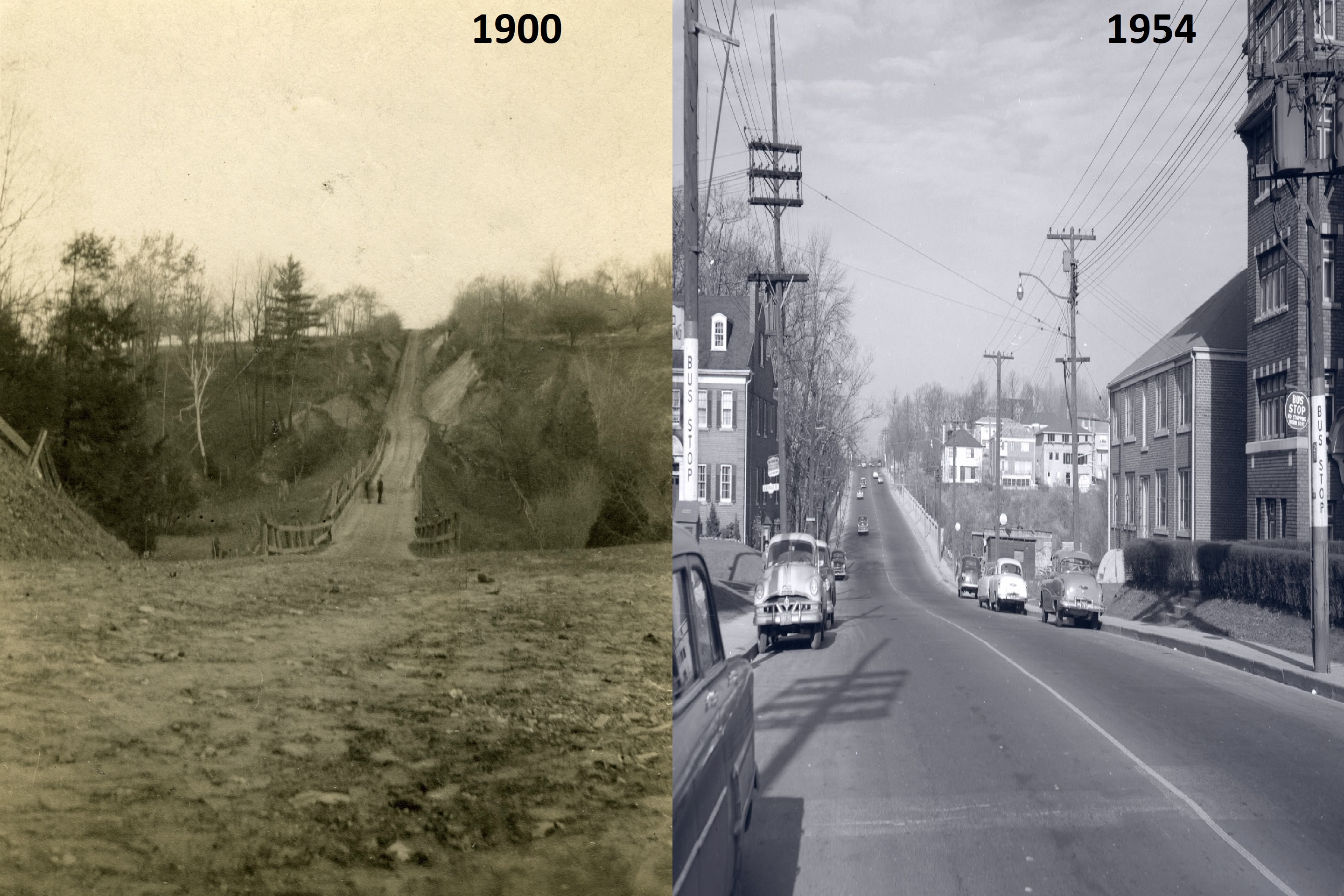
Cedarvale’s streets began to modernize in the 1930s as its population grew and changed, and the city’s geographies necessitated better connectivity. Housing south of the valley had developed in the 1920s, but north of the valley, development stalled. As a point, Glen Cedar Road was not built on at all in 1930. The answer to this: A new $250,000 bridge opened on Bathurst Street on August 6, 1930, replacing an earlier muddy construction over Cedarvale Ravine. The move opened the entire area for development in the 1930s, ’40s, and ’50s.
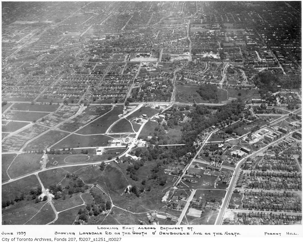
Cedarvale ad, The Globe, September 14, 1929. Credit: Toronto Public Library.Bathurst Street, looking north from Lonsmount Avenue, 1900-1954. Credit: Toronto Public Library.Cedarvale’s empty streets, Might’s Directory, 1930. As seen the above map from this issue, Cedarvale is part of the Wychwood District. Credit: Toronto Public Library.Cedarvale & Forest Hill, 1935. Bathurst Street and its new bridge are at the centre of the image. The north part of Cedarvale filled out by 1950. Source: City of Toronto Archives.
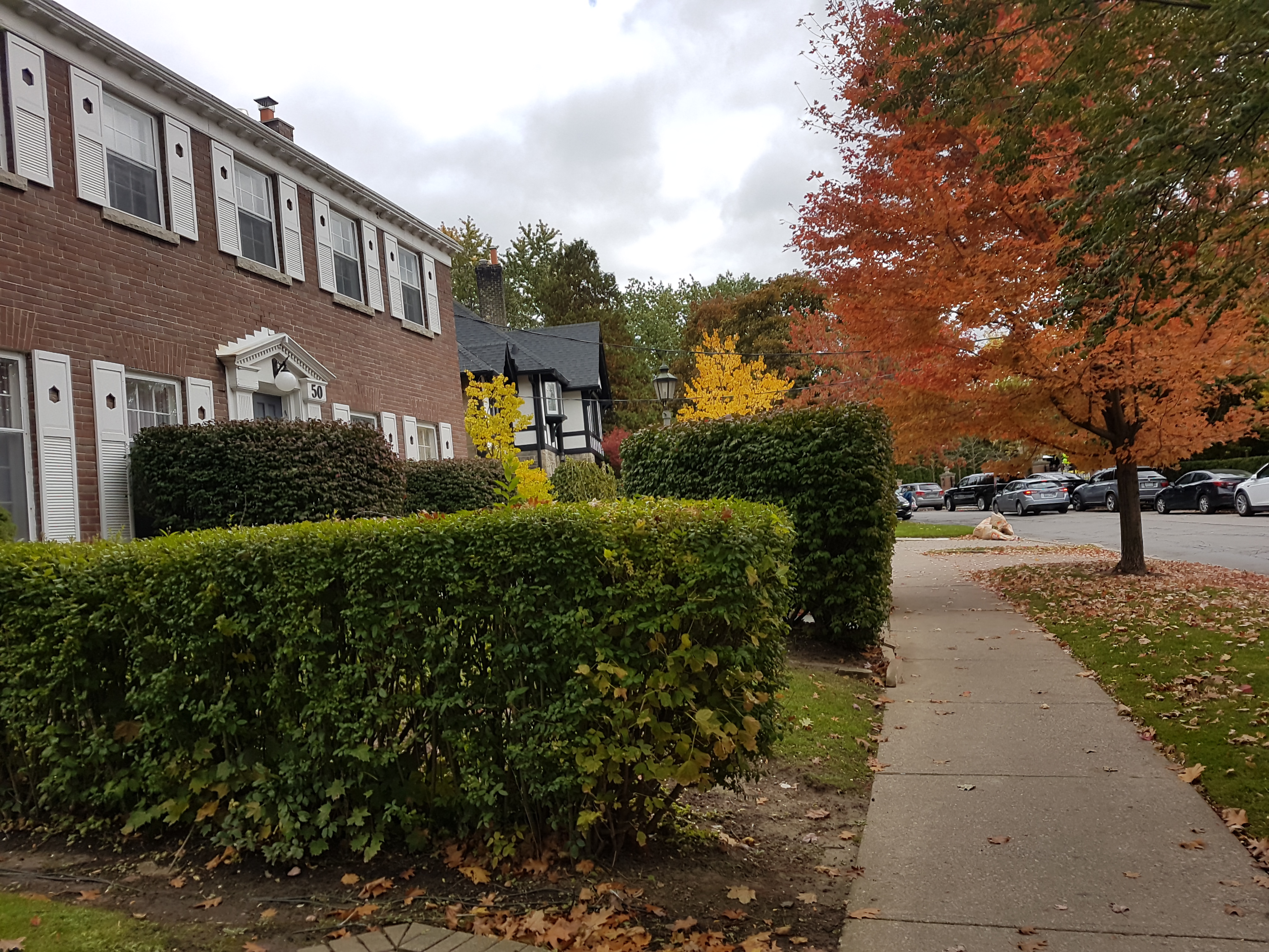
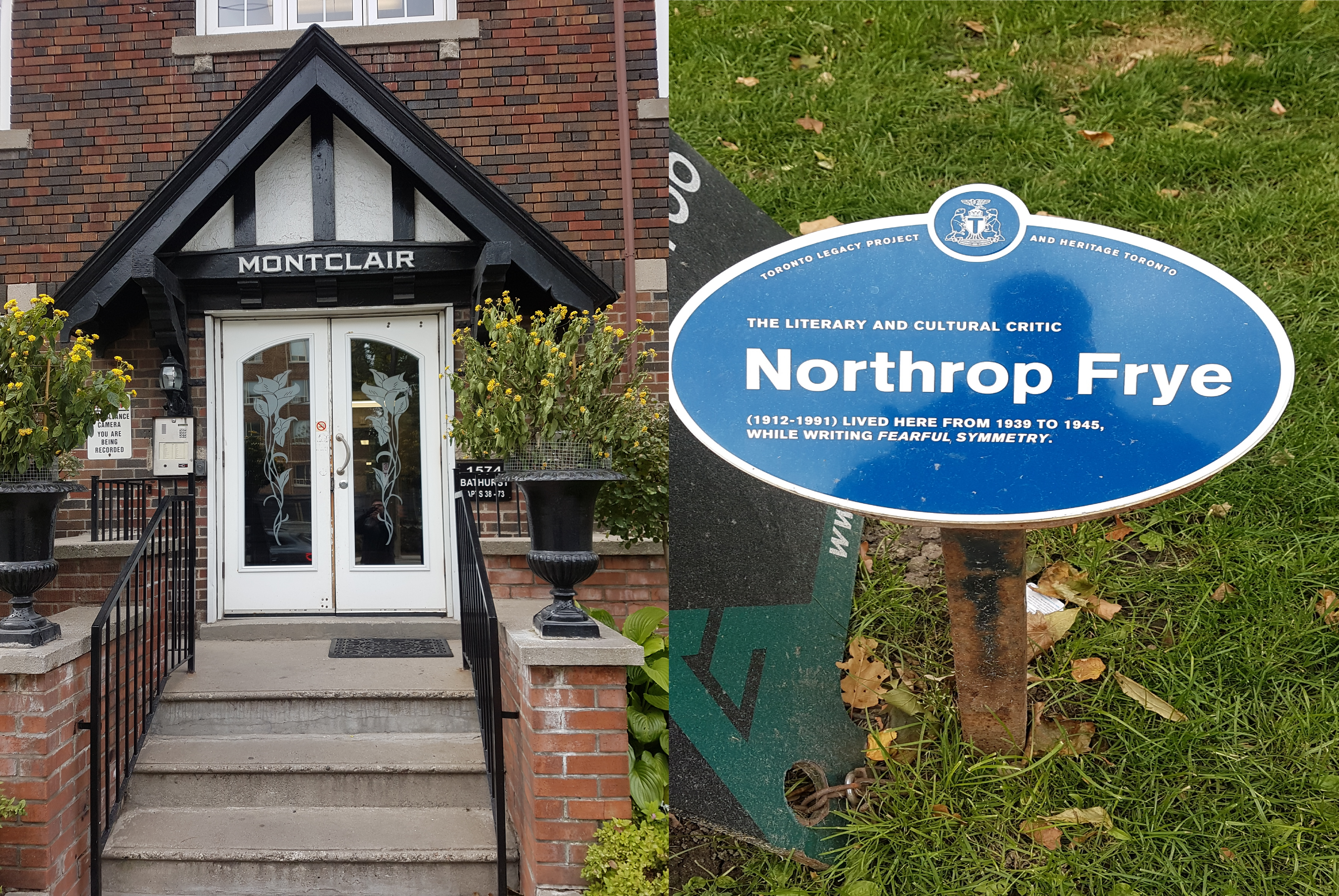
A specialty to York Township, which lacked the building restrictions of Toronto, Bathurst Street between St. Clair and Eglinton Avenues became a sort of ‘apartment row’ in the inter-war years, providing the home to new residents. Architect Victor Llewellyn Morgan designed a few of these walkup lofts, including the 1931 Claxton Manor. Wordsmiths Northrop Frye andErnest Hemingway also famously resided in Bathurst Street lofts.
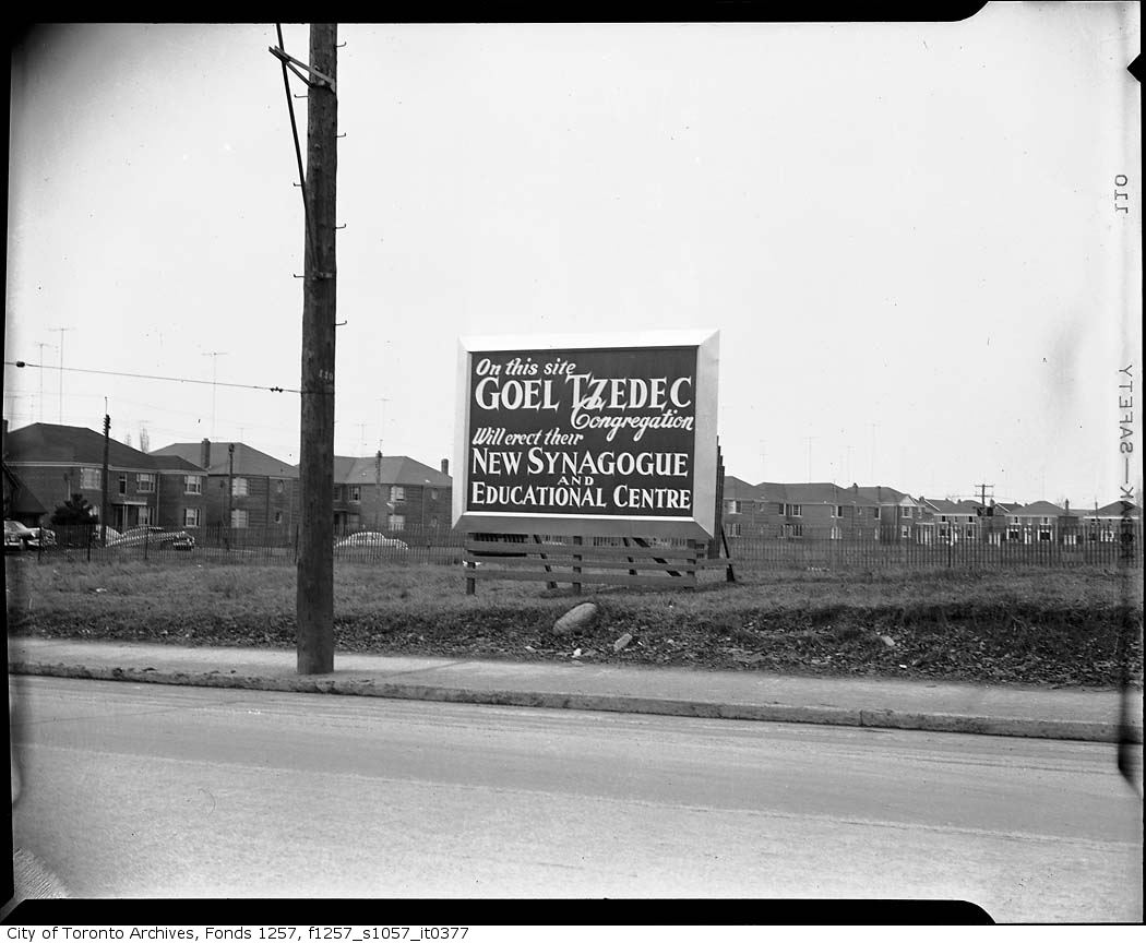
By the 1950s, the Jewish community also moved north from downtown Toronto. The Goel Tzedec Congregation, whose synagogue was situated on University Avenue, looked to Bathurst Street North for a new site. Despite community opposition, York Township Council had approved the erection of a place of worship in September 1949. After a merger with the Beth Hamidrash Hagadol Congragation, Beth Tzedec Synagogue was dedicated on December 9, 1955.
“Rap Synagogue For Cedarvale”, Globe and Mail, Nov 25 1947. Credit: Toronto Public Library.Site of Goel Tzedec Synagogue, 1951. Credit: City of Toronto Archives.
Cedarvale Ravine
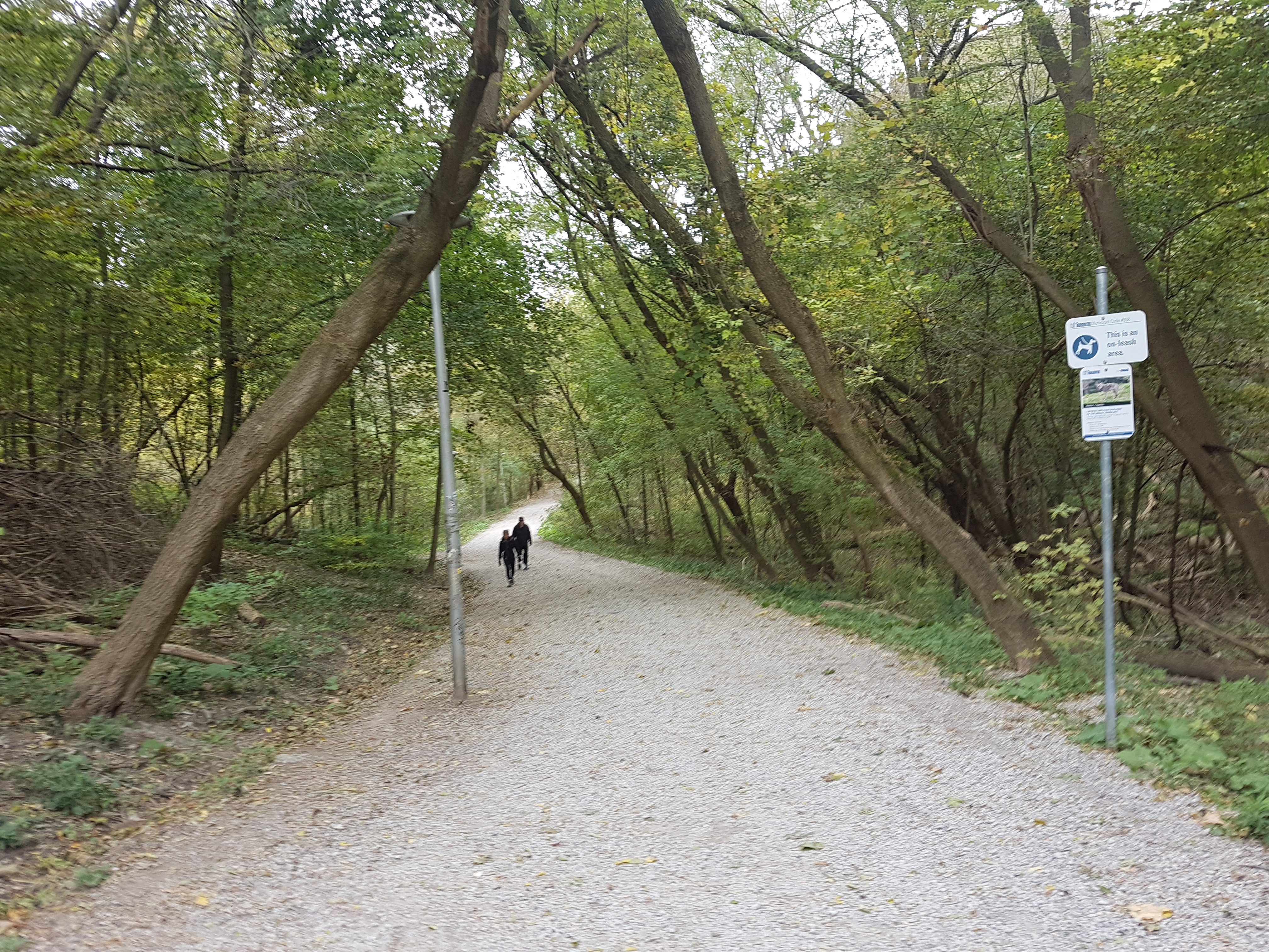
With numerous access points, Cedarvale Park is well connected to the neighbourhood as it was originally intended. The space itself can be thought of in two sections. To the north, there is an open field area with panoramic views to the downtown Toronto skyline.
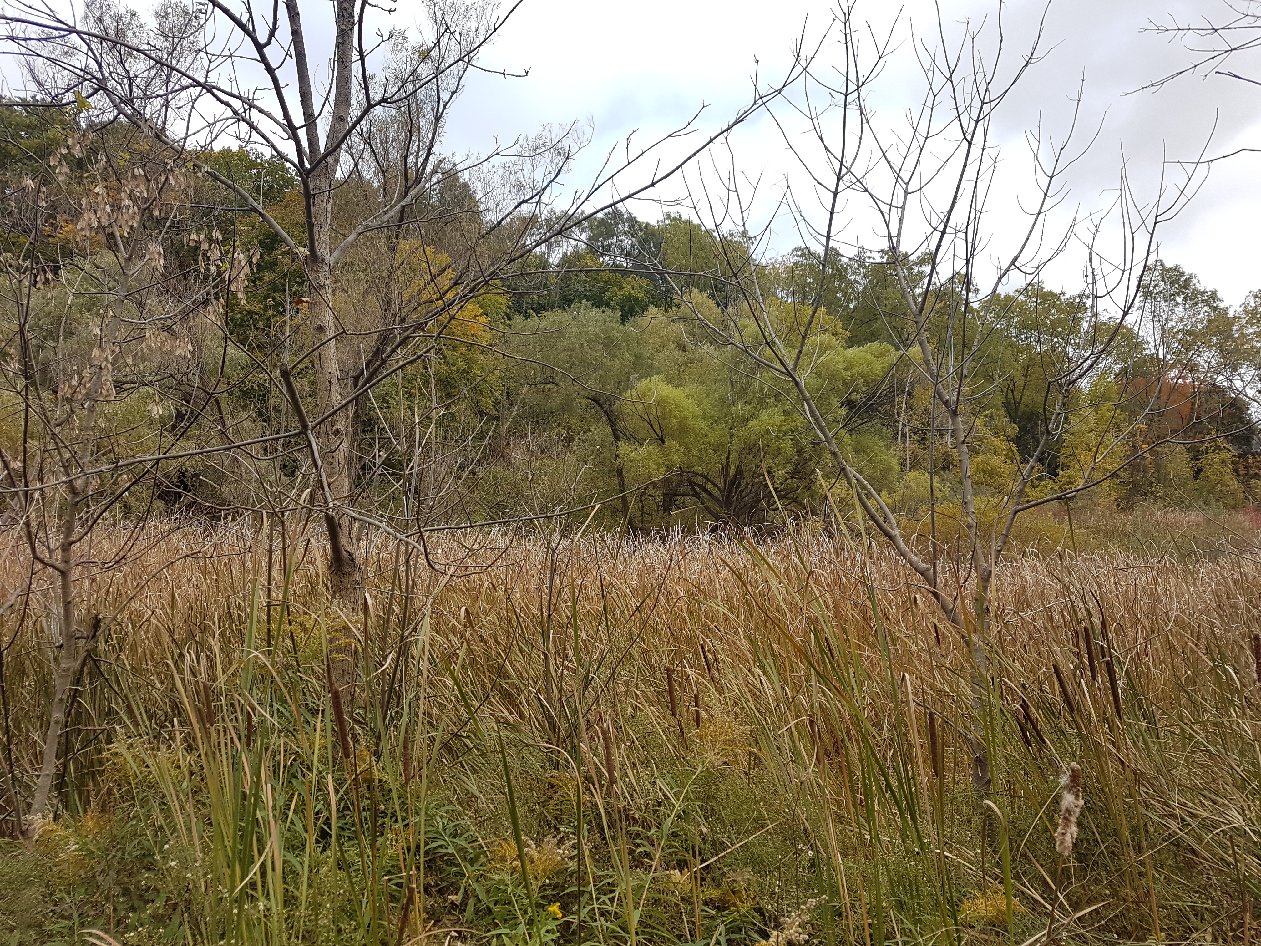
To the south, the park is a more wooded and wetland area with the overhead sights of valley-backing houses and the towering bridges of Glen Cedar and Bathurst. Castle Frank Brook also makes its appearance here, albeit briefly. In the 1910s, one could witness military demonstrations in the valley; in the 1920s, Ernest Hemingway is said to have meandered its grounds. But as much as Cedarvale Ravine is about the beauty all around, its story is as much about what is underneath — and what might have existed above.
Cedarvale, 1914. Credit: City of Toronto Archives
Spadina Subway/Expressway
Talk of a northward extension of Spadina Road began in the 1950s with formal plans by the Ontario Government announced in the 1960s. In June 1971, after serious community opposition, Ontatio Premier William Davis cancelled the controversial Spadina Expressway, halting construction at Lawrence Avenue. This threw rapid transit plans up in the air, specifically the Spadina subway that would have ran along the highway. Since a highway would not happen, the route of the subway fell under debate. Under the original plans, the subway would have run from Downsview Airport through the ‘Spadina corridor’ south to Eglinton and then through Nordheimer and Cedarvale Ravines to Spadina Road, where it would join with Bloor Street at St. George Station. A new proposal favoured a route under Bathurst Street to the Bloor-Danforth Subway.
“New Subway Proposal”, Toronto Star, January 6, 1972. Credit: Toronto Public Library.
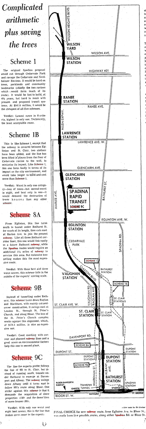
Metro Toronto Council established a task force to determine its possibilities. The task force analyzed more than 10 possibilities and narrowed it down to 5 final routes. Two of the routes were variations on the original Spadina corridor; the other three followed Bathurst Street. All five designs recommend leaving the portion from Wilson Station to Eglinton untouched.
The ‘winning proposal’ had the subway cutting under Cedarvale ravine, then under Claxton and Raglan Avenues, under Bathurst, then south on Albany to Bathurst station, then bypassing Spadina Station to join with St George. It was chosen because of the possibilities to extend the subway south of Bloor to join Queen and to the waterfront. The downsides though were the requirement of acquiring 150 more properties and the demolition of 85 more houses, and would require construction on Bathurst.
“Final Choice”, Toronto Star, January 12, 1972. Ranee Station is today’s Yorkdale Station. Note the station under the Spadina alignment at Bathurst and Heathdale. Credit: Toronto Public Library.
Proponents of the Spadina Expressway opportunistically favoured the original alignment because it meant that the Expressway could be added later. The borough of York – and the Cedarvale community specifically – did not favour either for the damage it would do to the ravine and for the expropriated properties. Preparations in 1971 had already interrupted recreational activities in the park. Debate continued into 1972. The Spadina line was a much needed relief line for the Yonge subway, which, even though was set to extend to York Mills from Eglinton in 1972 and to Finch in 1973, was at capacity. A decision was needed.
“Ten Citizens set out to rescue our ravines”, Toronto Star, June 10, 1972. Credit: Toronto Public Library.
Finally in January 1973, Premier Davis announced that it would fund 75% of the cost of the subway. It was up to Metro to decide the route of the subway. Council voted in favour of the Spadina alignment for its lower cost and construction time. The Borough of York agreed to support the subway under the grounds that the proposed Bathurst station at Heathdale would be nixed.
“The Spadina Route”, Toronto Star, January 19, 1973. Credit: Toronto Public Library.
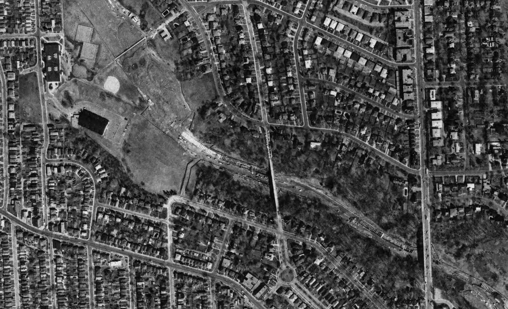
Toronto City Council opposed the vote and opted to appeal to the Ontario Municipal Board to have it changed to the Bathurst alignment. It actually announced that it favoured a third route to the west, but if forced to choose, Bathurst was it. During the hearings, another proposal came onto the table from William Kilbourn to follow the Canadian National Railway. Nonetheless, construction on the transit line began in 1975 with the line opening from Bloor to Wilson in 1978 with two stations at Eglinton and St. Clair serving the Cedarvale area. The cancelled station at Heathdale explains long distance between stations.
Cedarvale, 1975. Note the cut and cover method of tunnel building. Credit: City of Toronto Archives.
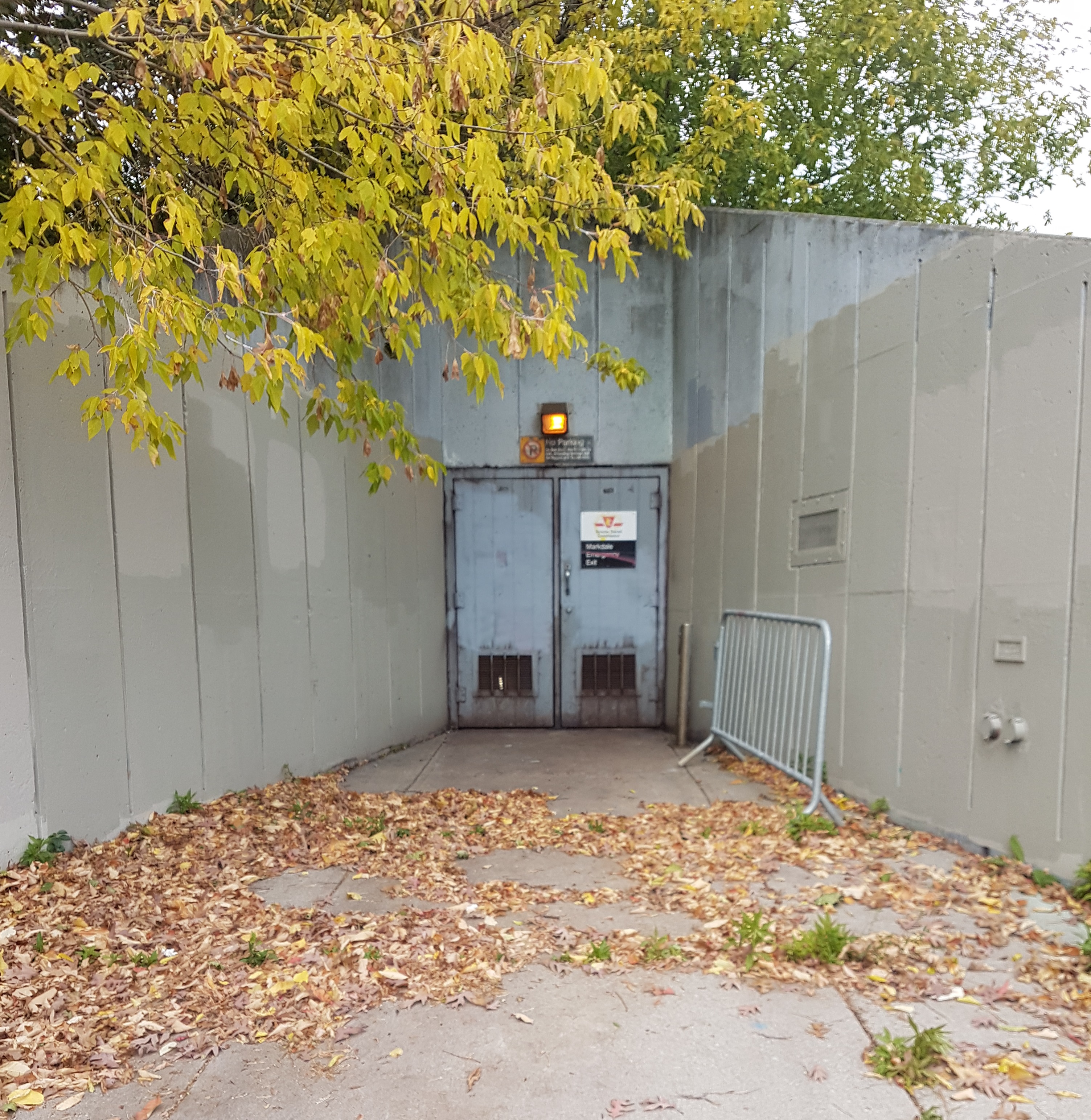
Within Cedarvale Park, an emergency entrance at Markdale provides an obvious door into what lies below, but the rumblings of the subway are masked by the replenished canopy and wetland (albeit, the ravine like others in Toronto faces ecological collapse).
At Heath Street, one ascends out of Cedarvale Park near the north entrance of St. Clair West Station. Below, Castle Frank Brook continues under the subway station towards Nordheimer Ravine, leaving behind an area with layered history.
Ontario Place is nostalgia. We all have vague or even not so vague memories of going down to Ontario Place with our families for a fun-filled day. But things are changing at the park.
Opened in 1971, the idea of Ontario Place came following the success of Expo 67 in Montreal. Ontario Place was a display in modernism — a showcase of the future. The 1960s and ’70s were a transformative time culturally and architecturally in Toronto. Buildings such as Toronto City Hall and the TD Centre ushered Toronto into a new era. Ontario Place was part of that optimism. Brightly coloured pavilions echoing Expo would scatter its grounds along with giant silos, but the signature structure was and still remains the iconic, space-aged Cinesphere, featuring new IMAX movie technology. The buildings were the unique designs of Eb Zeidler, a German born architect working in Canada.
Cinesphere under construction, circa 1970. Credit: Toronto Public Library.
Continuing Toronto’s century long obsession with shaping and reshaping its waterfront, the land to house Ontario Place was a new addition to the city’s geography. Two infill islands would be built south of Lake Shore Boulevard near the Exhibition Grounds, connecting to the mainland by bridges.
Ontario Place under construction, 1970. Credit: City of Toronto Archives.
The park would grow over the years. A central rink doubled in the summer as roller rink and as a skating rink in the winter months. The Ontario Place Forum offered musical entertainment from Teenage Head to Johnny Cash to Blue Rodeo to BB King to The Tragically Hip. The Toronto’s only waterpark — Froster Soak Park — would open in 1978 on the East Island. Wilderness Adventure Ride would excite log-riding ‘thrill seekers’ starting in 1986.
Ontario Place in 1980. Silos and Cinesphere as a backdrop. Credit: Toronto Public Library.B.B. King at the Ontario Place Forum, 1981. Credit: Toronto Public Library.Newly opened Wilderness Adventure Ride, 1986. Credit: Toronto Public Library.
Ontario Place closed in 2011. Although many of the park landmarks are still intact and Ontario Place Corporation is still active, the sites serve almost as urban relics. It’s an odd yet intriguing contrast walking there today: one thinks of the circumstances of its construction — the hope and intent for grandeur and futurism — and then its sad abandoned state — how that vision didn’t ultimately hold up. Maybe it was never meant last. Dwindling attendance put an end to it.
As mentioned, there were attractions added over the years, but perhaps Ontario Place never matched up as a ‘modern’ amusement park to its suburban counterpart Canada’s Wonderland. As the years grew, I certainly heard it mentioned less and less as a destination. Oddly, I actually encountered the grounds more as an adult than as a child; albeit this was because attending concerts finally became a reality and the Molson Amphitheatre — the successor to the Forum — was a great venue for it, so I was only passing through.
The good news: revitalization is in Ontario Place’s future. A long-term vision has the grounds becoming a destination once more through a lot of re-purposing. One part of this plan is already in effect: Trillium Park and William G. Davis Trail. This extraordinary space was carved out parking lots and offers some of the most spectacular skyline views of Toronto.
As a showing of the possibilities, Ontario Place held a Winter Lights Exhibition in the winter of 2018, transforming the grounds and showing them off in a different, well, light. A walk around the artist creations offered neat views of the abandoned park, instilling both a sadness and perhaps some optimism for the next stages. Maybe then Ontario Place will be the future once more.
Milliken District Park lies in Scarborough’s northern reaches, hugging Steeles Avenue East between McCowan Road and Middlefield Road. Its story includes the transformative move from farmland to suburbia, as well as its importance to the community both past and present.
The park’s focal point is Milliken Pond, famed for the great wildlife that frequent its waters – most notably, the trumpeter swans. If one is lucky, one might also catch a look at the great blue heron. (I don’t have the pleasure on this day.)
Beyond its great aesthetic, the body of water also serves a functional purpose as a storm-water management pond. According to The Toronto and Region Conservation Authority, which manages the larger Highland Creek Watershed (of which the park is part of), Milliken Park was built in a low-lying area, and this basin collects the run-off rainwater from the surrounding environment and deposits it into the Highland Creek via underground pipes.
Adjacent to the pond is a great bit of greenspace (and my favourite aspect of the park) called Milliken Forest. This wooded area predates the creation of Milliken Park and has remained in tact even when the farmland around it was redeveloped (more on this below). It joins spaces like Passmore Forest, Brimley Woods, and Wishing Well Woods as woodlots that exist as what I call ‘rural leftovers’.
Milliken Park before redevelopment, 1965. The area that became Milliken Park was Lots 22 and 23 of Concession Road 5, historically farmed by families such as the Mitchells and Myles’. That also looks to be a creek running through the western third. Credit: City of Toronto Archives.
While they aren’t the great expansive forests of the Don Valley or the more untouched areas closer to the mouth of the Highland Creek, these spaces are important. They are key as homes to wildlife and help to mitigate the larger impact urbanization has had to the Highland Creek Watershed as a whole. For people, they are gems and escapes.
Exploring Milliken Forest piques my interest in labyrinths (albeit sans a mythological beast in the middle). One walks with hopefully a general sense of where they are, but ultimately not knowing where one path may lead. There are several forks in the road, leading me to also think of the Robert Frost poem ‘The Road Not Taken’ about choice, regret, and self-discovery.
On the theme of discovery, moving out of the trees, I locate a cache placed within the park. Geocaching is a global scavenger hunt where individuals hide trinkets of many sizes and shapes in personally significant locales in hopes of drawing folks to those places. I would say Milliken Park is perfect for that — people should know about this place.
A gaze around and one can see this is a well-designed, well-utilized park. In addition to the variety of programming at the community centre, there are walkers, picnickers (barbeque, anyone?), people-watchers, children on various playgrounds, and athletes. A regular sight for a beautiful Sunday morning I imagine. This connection goes back to the intent of the park in the first place: to serve the great amounts of new residents. News articles at the time wrote about the integral part greenspace played in linking new neighbourhoods.
Globe and Mail, January 7, 1984. Credit: Toronto Public Library Globe and Mail Archives.
For historical context, the Millken Park area was subdivided in the 1980s, continuing a process that had been going on in Scarborough since the 1950s. Going through historical aerial maps, one can see suburbia marching northward with every decade. It’s interesting when you get to a year like 1975 and you see that a good part of the borough up until Finch Avenue has been populated, yet still a simple drive or even look north produces agricultural fields. It’s a weird in-between period for Scarborough. For the areas of North Scarborough around Steeles Avenue, it’s odd to think of them as fields as late as the 1990s in some spots.
Milliken Park and its subdivisions under development, 1985. The farmhouses look to be gone. The creek that might have ran through the property has been buried and the stormwater pond has taken shape. Previously two parallel roads north and south of Steeles Avenue, McCowan Road has been rerouted to curve through the intersection, eliminating the jog. To the south, Passmore Avenue (5th Concession) has been largely overtaken by housing and today only remains in segments.
Milliken Park looks to have been possibly created as a ‘deal’ between developers and local government to allow greenspace in new areas of suburbia. The article below outlines the design, planning, and marketability of new parks in new suburbs, and the views different cities and developers take on the form and utility of parks. It also states that Milliken Park was supposed to have ‘model farms’.
Globe and Mail, July 20, 1985. Credit: Toronto Public Library Globe and Mail Archives.
A final feature of the park is the beautiful meadow and garden area towards the northwest quadrant. The gorgeous space is prime for wedding shoots, which indeed happened on this day, or just quiet contemplation.
Eglinton Avenue is Toronto’s east-west midpoint. It is the only street in the city (although took some doing in the 1950s and 60s to make it so) that traverses all six former municipalities. This attribute has made it perfect for a crosstown transit line. Although it was laid out in 1793 as the Third Concession from Lot (Queen) Street, I would argue that Eglinton’s form, at least from Yonge Street to Latimer Avenue, as we know it today does not begin to take shape until 130 years after it was laid out.
Might’s correct city directory map of Greater Toronto, ca. 1940. The extension across the Don River branches were completed by 1956. In 1967, Richview Sideroad in Etobicoke was absorbed into Eglinton Avenue when the two streets were joined via a bridge across the Humber River. Credit: Map and Data Library, University of Toronto.
This stretch of Eglinton Avenue west of Yonge Street and the surrounding area was historically part of the Village of North Toronto. Even though the village was absorbed into the City of Toronto in 1912, allowing it to reap the benefits of better service delivery, the street was still a sparsely populated dirt road. It wasn’t until the coming decades when Eglinton’s fields morphed into a mixed residential and commercial zone. By 1930, the road was paved and possibly widened.
Eglinton Ave, west from Yonge, October 19, 1922. Fonds 16, Series 71, Item 1637. Credit: City of Toronto ArchivesEglinton Avenue west from Yonge Street, April 23, 1930. Fonds 1231, Item 1646. Credit: City of Toronto Archives.
At Duplex and Eglinton stands a power station. The yellow-bricked structure was built in 1920 at a time of rapid expansion in Toronto. With the Toronto Hydro-Electric System (now known as just Toronto Hydro) becoming the only distributor of power in Toronto at the tail end of the 1910s, Toronto was experiencing the pressures of an electrified transit network and a growing population.
The Eglinton sub-station was one of many built in this era to cope with this demand, specifically serving the surrounding residential community and “the Metropolitan radial line on north Yonge Street and subsequently to the TTC Yonge route and Eglinton Carhouse in the area.”
Eglinton Sub-station, August 10, 1925. Fonds 16, Series 71, Item 3975. Credit: City of Toronto Archives
Related, a short distance across from the station, there’s a row of mid-rise apartments. The positioning of these 1930s Art-Deco inspired buildings one after the other leads one to conclude that this was by design, although I wonder at their context considering the larger history the Toronto has with this kind of housing stock.
One historical narrative has been that whereas at the time the City of Toronto avoided this housing style, outlying communities like York and Forest Hill including them in their planning. For example, a more prominent row of these decorative lofts exists further west on Eglinton near Bathurst Street in the former Village of Forest Hill. These ones close to Yonge would have existed on land already annexed to the city, though. Curious.
Next, Eglinton Park has a neat past. As Lost Rivers explains, long before its colonial period, Huron peoples occupied its land and the nearby area – notably, the site of Allenby Public School – in the 15th century. In more recent history, the park was a brickyard! Capitalizing on the clay beds created by the now buried Mud Creek, James Pears ran his establishment here beginning in the 1880s.
The Eglinton Hunt Club (foreground) & Pears Brickyard (background), looking southeast,1920. The Pears home (now gone) can be seen at the top of the image at 214 Eglinton Avenue. A water tower stood on Roselawn Avenue near Avenue Road. A communications tower is in its place today. Credit: Toronto Public Libary
The modern geography within the park shows off the layers of time: the ‘dug-in’ escarpment leading up to Oriole Parkway, the hilly topography of Roselawn Avenue. Pears formerly worked out of today’s Ramsden Park in Yorkville before moving up Yonge Street, which has similar rolling features. These are the former lives of our parks.
Later, with North Toronto annexed, the City of Toronto attempted to purchase the yard from Pears before outright expropriating it in 1922 when he refused. The entire exercise came at a time in the 1920s and 30s when the City’s Parks Department was expanding, creating parkland and accompanying infrastructure such as shelters, gazebos, and bandshells. In fact, the Toronto Archives has a wonderful collection of ink & pencil drawings as a part of an Architectural Drawings Scrapbook prepared by the Department of Buildings for the Department of Parks and Recreation.
Eglinton Park (Roselawn Avenue) Shelter, August 12, 1930. Fonds 200, Series 372, Subseries 1, Item 934. Credit: City of Toronto Archives.
Pears’ legacy did live on for a while as the space was unofficially known as Pears Park for a time (and still might be?). Modern amenities have been added to the park since then of course, including a community centre, playground, and a Cretan maze via the Toronto City of Labyrinths Project!
A final sign of the street’s arrival was the eventual population of the street with commercial activity. The north side of Eglinton east of Avenue was one of the first retail blocks, coming to us around 1930.
CANATCO house index map of Toronto and environs, 1932. Credit: University of Toronto Map & Data Library.Eglinton Ave. north side Avenue Rd. looking east, April 23, 1930. Fonds 200, Series 372, Subseries 58, Item 1223. Credit: City of Toronto Archives.
With the opening of the Eglinton Theatre in 1936 to serve the growing local community, another commercial dimension was added. Neighbourhood theatres were abundant in Toronto by World War II, but The Eglinton was a benchmark in grandeur.
Whereas other ‘nabes‘ were more low-key in aesthetic, the Kaplan and Sprachman-designed Art Deco movie house and its neon-lit tower announced itself on the commercial strip. It’s amazing considering this was also during the Great Depression. It was operational until 2002, remarkably late in the history of comparable theatres. Today it’s the Eglinton Grand.
After climbing off the 83 bus at Queen Street, I walk back to the north end of Leslie Grove Park and start exploring from there. I’m immediately greeted by a series of trees lining the east side of the park (located at Jones and Queen in Leslieville) which I learn later on relate to the site’s history and founder.
Moving past the baseball diamond, I am led to a splash pad with chalk designs. Beside that, a playground and a clubhouse beyond that. Like most parks, this is a very family-friendly environment.
At corner of Jones and Queen, I come across a flowery path and commemorative plaque by Heritage Toronto. Its subject: the park’s namesake, Mr. George Leslie, and his tree nurseries which were once hosted by this site. Across the street is the much photographed mural of the neighbourhood also named for him. Highlighted within it is another local hero, Alexander Muir.
On the way out, I take a final closeup of the trees towering over the park, which is the apt location for an annual tree festival organized by LEAF, Toronto Parks, and the local City Councillor Paula Fletcher.
My introduction to Withrow Park was by nearly interrupting a wedding shoot. In doing so, I unknowingly also stumbled into the essence of this sizable park.
Entering the park from the south end at Carlaw Avenue, I immediately saw people tossing and hitting a baseball in the soccer field. As I ventured past the wedding party, the great slopes reminded me of the other parks in the east end – Riverdale Park East to the west and Greenwood Park further east. On its toboggan-friendly hills I saw people reading books and in the valley below, picnickers enjoying a late lunch.
Traveling around the side of the soccer field, I noticed a hockey rink, which I later (and delightfully so) discovered was the site of Toronto Maple Leafs outdoor practice a few years ago. North of the rink was the path-ridden, tree-covered portion of Withrow Park. If the area I came from was the subdued side of the park, this was the lively portion. Bicyclists, parents and children on family outings, and adolescent revelers took in the great afternoon. It made for a delightful stroll, and one which necessitated a return with company. It was also here where I re-affirmed how parks bring character to a neighbourhood and become focal points in how we build communities. Withrow Park does just that.
Withrow Park recently hosted a Shakespeare in the Ruff and continues to hold a Farmers Market every Saturday from now until late October. These tidbits capture the essence of this public arena: that it is a multi-acre park enjoyed by a multitude of people in a multitude of ways.
With this decade, Withrow Park celebrates on hundred years of serving the Riverdale community and the hoards of residents over the years. So beyond its many uses by many people in this lifetime, its sledding hills and skating opportunities seem to link multiple generations with one another.
Hockey, 1920 City of Toronto Archives Fonds 200, Series 372, Subseries 52, Item 1095Sledding, 1914 City of Toronto Archives Fonds 200, Series 372, Subseries 52, Item 255


