Scenes From Crescent Town

I have a borderline obsessive transit habit. Whenever I travel out of Kennedy Station, I have to sit on the north side of the subway car. Doing that gives me a good view of Warden Woods going by Warden Station and of the Don Valley as it passes under the Bloor Viaduct.

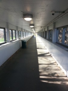
But sitting on the north side of the train presents another sighting: the pedestrian bridge at Victoria Park Station. For the longest time, I never knew what it looked like inside. Or where it went. Or if people use it.

Crescent Town Pedestrian Bridge (1)

Now, walking through it for the first time, I know the sky bridge over Victoria Park Avenue leads to Crescent Town, the towered community in the southeast corner of East York. And yes, people use it. It’s an important link for them and their main transit hub.

Crescent Town Pedestrian Bridge (2)

My introduction to Crescent Town comes with a neat mural that summarizes the neighbourhood with beautiful scenes of its past and present. Funded through the city’s StreetARToronto program, it’s entitled ‘Tempo, Toil, & Foil’ and was created by artists and community members.

Crescent Town Mural (1)

Crescent Town Mural (2)

Crescent Town (1)

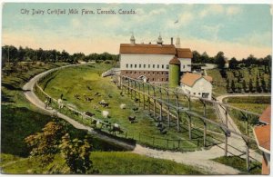
This is Dentonia Park, the 6-acre athletic field that fronts a courtyard and its surrounding apartment towers. It’s named for Dentonia Park Farm, the dairy farm established here in 1896 by Walter Massey of the famed Toronto family of benevolent industrialists. It was named after his wife, Susan Denton Massey. Dentonia Park Farm stretched from Dawes Road to Pharmacy Avenue and Dentonia Park Avenue to Medhurst Road.

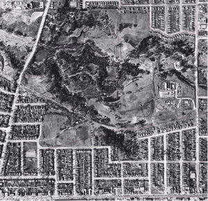
CrescentTownAerial1924
Dentonia Park Farm, Goads Fire Insurance Atlas, 1924. Source: Old Toronto Maps.
CrescentTownAerial1956
Dentonia Park Farm aerial, 1956. Source: City of Toronto Archives. The section of Victoria Park running adjacent to Crescent Town was built when the community was built.
Dentonia Farm Postcard 1910 (2) East York Then and Now
Dentonia Farm Postcard, circa 1910. Source: East York Then and Now.

Despite the continuity of open space, it’s hard to imagine what this land would’ve looked like a hundred years ago. But I get a little sign of it through the unusual rolling contours in the otherwise flat park. I don’t know it for sure, but my hunch is that the dip in the land hides a former creek valley.

Dentonia Park (1)

Dentonia Park (3)
At the far west end of the park, a tree lined path shields a bit more history about Dentonia Park Farm. The ‘Crescent’ in Crescent Town also goes back to the Masseys, who gifted land for Crescent School, once located here.

Dentonia Park Farm plaque

Dentonia Park Hydro Corridor

Following a corridor of hydro towers (more on that later), I circle back around to the main path and find a way down to Crescent Town Road and Massey Square. Ringed around the streets is the second group of towers in the community.

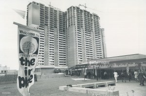
Massey Dairy Farm was bought by developers in 1969, and by 1971, they constructed apartment towers and marketed the area as Crescent Town, a new way of living in the city.
Crescent Town (2)

Crescent Town
Crescent Town construction, September 16, 1971. Source: Getty Images.

Crescent Town Massey Square Pedestrian Bridge

This development wasn’t isolated to Crescent Town. Across Toronto in the 1960s and 1970s, tower living became the planning focus of the city. Communities were created out of former farms, and then marketed as having onsite amenities  – laundry, shopping, recreation – and conveniently located near transit or highways. The objective of these high-rise towers was to make a profit out of low-cost social housing.

CrescenTownAerial1965
Crescent Town Aerial, 1965. Source: City of Toronto Archives.
CrescentTownAdDec311971
Crescent Town Ad, Toronto Star, December 31, 1971. The sky bridge was a vital part even since the neighbourhood’s inception. Source: Toronto Star Archives.

But the problem with communities like Crescent Town and St. James Town (and Regent Park, for that matter) was that as much as they were made to be their own self-contained ‘towns’, it instead made them isolated from the city around them.

CrescenTownAerial1973
Crescent Town Aerial, 1973. Source: City of Toronto Archives.

As I approach the towers of Massey Square, I’m reminded of a fortress. My goal is to get to the creek trail I know exists on the other side, but I’m not sure if I can get there through the wall of highrises. It’s a definite physical and psychological barrier. Instead, I walk to Victoria Park to get there, passing Crescent Town Elementary School.

Crescent Town Elementary School (1)

Crescent Town Elementary School (2)

One isn’t cognizant of city borders while traveling them (or, at least, I’m not), but across the road is Dentonia Golf Course (also once part of the Massey property) and Scarborough. I’m standing in East York. Further south is the Old City of Toronto. It’s a neat crossroads. It’s our local Four Corners USA.

Dentonia Golf Course

A long stairway leads into the valley of Taylor-Massey Creek. With winter approaching, it’s a rather dead and haunting scene. But even so, it’s easy to see this is a great space.

Massey Creek Trail (1)      Massey Creek Trail (2)

There’s a constructed wetland, and several paths that traverse the rolling topography of the park. By a lookout point, there’s the remnants of a little fire, freshly extinguished and filling the air with its ashy aroma.

Massey Creek Trail (3)

Massey Creek Trail (4)

Massey Creek Trail (6)

Massey Creek Trail (7)

At the park’s highest point, I find the Massey Goulding Estate house, otherwise known as Dentonia. Constructed here in 1921, the cottage is built in a very distinct Tudor style. I struggle to think of other examples of Tudor architecture in the city – there seem to be very few, so this is a treat. Perfectly positioned to overlook the farm once upon a time, Dentonia is its last remaining structure today.
Children's Peace Theatre Dentonia (1)

Dentonia Farm Postcard 1910 (1) East York Then and Now
Dentonia Farm Postcard, circa 1910. Source: East York Then and Now.
Dentonia Park Farm Library Archives (1)
Dentonia Park Farm, undated. Source: Library & Archives Canada.

After the dairy enterprise ceased, the house and park came under the ownership of the Borough of East York and then the City of Toronto. Children’s Peace Theatre – celebrating its 15th year in 2015 – now makes its home inside (and outside) Dentonia.

Children's Peace Theatre Dentonia (2)
Children's Peace Theatre Dentonia (3)

Descending some ancient narrow stairs back down, I follow Taylor Creek Trail under and past Dawes Road. Taylor, by the way, is the other old, industrious Toronto family, who owned mills along the Don River, including Todmorden Mills.

Taylor Creek (1)      Taylor Creek (2)

Taylor Creek Trail continues westward until it meets the Don River near the Forks of the Don. Tracking the trail the entire way sounds like fun, but I opt to take that adventure another day. Instead, I make towards the trail’s entry/exit point towards Lumsden Avenue.

 Taylor Creek Trail (1) Taylor Creek Trail (2)

Lumsden isn’t my goal, however – the Taylor Creek Hydro Corridor is. I’m fascinated by this informal path because of its former incarnation as a railway corridor. Looking at the dead vegetation lining it only increases the thoughts of ghosts and past lives.

Taylor Creek Hydro Corridor Canadian Northern Ontario Railway (1)

Yes, Taylor Creek Hydro Corridor once housed tracks for the now defunct Canadian Northern Ontario Railway, which ran from the also lost Todmorden Station on the north side of Don River, through Taylor Creek valley, and northeast into Scarborough and beyond. It bisected Dentonia Park Farm (now at the north end of Dentonia Park).

CanadianNorthernOntarioRailwaySubway1913
Canadian Northern Ontario Railway, 1913. Source: Toronto Historic Maps.

The Bloor-Danforth subway tracks between Kennedy and Victoria Park Stations are the only tangible remnants of the CNOR’s former corridor in Toronto, which was out of use in the city as early as 1925. (And here I thought the subway was carved out of farmland and expropriated homes). The rest has been swallowed up by the city around it. If one looks, however, the signs of existence are there. (Note to self: take on this adventure).

CanadianNorthernOntarioRailwaySubway2015
Canadian Northern Ontario Railway, 2015. Source: Toronto Historic Maps.

Following the hydro corridor east would bring me back to Dentonia Park, but I make my exit at Eastdale Avenue. Concluding my travels, I find my way back to Dawes Road and follow its odd diagonal routing down to The Danforth. That too is something to explore.

Taylor Creek Hydro Corridor Canadian Northern Ontario Railway (2)         Taylor Creek Hydro Corridor Canadian Northern Ontario Railway (3)


Useful Links

Edward Relph – Toronto: Transformations in a City and Its Region – ‘Chapter 5: A Post-suburban Skyscraper City’

ERA Architects – Toronto Tower Renewal: Lessons From Crescent Town

Globe and Mail – “A Toronto subway station redesign links neighbourhood and nature” by Dave LeBlanc

Ron Brown – In Search of the Grand Trunk: Ghost Rail Lines in Ontario – ‘Chapter 19: The Canadian Northern Railway: Ontario’s Forgotten Main Line From Toronto to Hawkesbury’

Scenes From Warden Woods Park

Toronto Neighbourhood Walks Project – Crescent Town

Toronto Star – “Once Upon a Time: Dentonia Park born of Massey’s dairy dream” by Valerie Hauch

Torontoist – “Historicist: ‘If It’s City Dairy It’s Clean and Pure. That’s Sure.'” by Kevin Plummer

Train Web – Canadian Northern Ontario Railway – Toronto to Ottawa Line

Urban Toronto Forum – ‘Rare Maps of Toronto’ Thread | Page 12

Scenes From Brimley Woods Park

After checking out L’Amoreaux Park and Passmore Forest, a visit to Brimley Woods Park seemed appropriate.

Their stories are very similar: they both border on the Highland Creek (albeit, Passmore Forest on the West Highland and Brimley Woods on the East Highland) and they’re both the forested remnants of rural Scarborough. Oh, and they’re both gorgeous.

Brimley Woods

Access to the woods comes from a trail off Finch Avenue. This path is part of the North Scarborough Green Loop, which uses streets, ravines, and parks to create a walking, biking, and running corridor in Agincourt & L’Amoreaux.

North Scarborough Green Loop East Highland Creek 1

As expected, a look down at the East Highland produces a waterway that’s seen the effects of human interference. But what catches my eye more is the massive and thick orange canopy across the way.

North Scarborough Green Loop East Highland Creek 2

North Scarborough Green Loop East Highland Creek 3
The bending path continues on towards the Finch Hydro Corridor, but a bridge over the creek leads the way to the woods.

North Scarborough Green Loop East Highland Creek 4

Brimley Woods Park 1
The first thing I encounter in Brimley Woods is what I initially think is a jungle gym. It’s actually the first activity station in the Vita Course – a fitness ‘gauntlet’, as I think of it. My first thought was that it was installed by one of the local schools, but I suspect that it’s something separate.

Brimley Woods Park 2

The second thing I encounter: a leftover from Halloween.

Brimley Woods Park 3

With the tall tree tops above and the leaves blanketing the ground below, I get to exploring the park’s meandering paths. At 8.1 hectares, it’s big, sure, but not too big. It’s very easy to orientate oneself and very hard to get lost.

Brimley Woods Park 4            Brimley Woods Park 5

The woods were part of the farm of Marshall Macklin, an Irish pioneer who came to Upper Canada in 1828 and settled here in Scarborough. The trees themselves are 100 to 200 years old.

Lot 24 (and 23) Concession IV, 1878 Illustrated Historical Atlas of the County of York. Forest Home appears in the middle of the lot. Brimley Woods is shown as a wooded area in the southernmost part of the lot.
Lot 24 (and 23) Concession IV, 1878 Illustrated Historical Atlas of the County of York. Brimley Woods is shown as a wooded area in the southernmost part of the lot.

In History of Toronto and County of York, OntarioMacklin is described as a Presbyterian, a Reformer, and amassing 500(!) acres of land to eventually leave to his 13(!) children. In The Township of Scarboro: 1796-1896, he is also noted as “the pioneer planter of trees along the roadsides…”, an example others apparently followed in the township. According to the Scarborough Archives, Brimley Forest was known as ‘Macklin’s Bush’ and later became a city park when the Macklin property was redeveloped.

The Macklin name lives on today in Macklin Public School and Macklingate Court,  which houses the 1851 Macklin family homestead, Forest Home.

BrimleyWoods1965
Brimley Woods aerial, 1965. Forest Home is in the top left corner. Source: City of Toronto Archives.

Brimley Woods is considerably larger than Passmore Forest, and according to the Toronto & Region Conservation Authority, this is an advantage because allows for interior habitat for animals. Unfortunately, I don’t spot any on this day. There are people, though!

At one point I encounter a exit/entry point off Brimley Avenue, but instead opt to keep exploring. The entire time the same recurring thought keeps circulating in my head: “This place actually exists! In Scarborough! Why haven’t I heard of or been here before?”

Brimley Woods Park 7
When I do exit, it’s at the southeastern corner of the park. I follow the ravine back down to the Finch Avenue, passing some hillside planting.

North Scaborough Green Loop East Highland Creek 5

Where the creek runs under the street, a marker dates the piece of infrastructure. 1972. Sounds about right. The beginning of the suburbia in Scarborough.

North Scaborough Green Loop East Highland Creek 6
By 1975, the Macklin farm would be completely subdivided and transformed by development. Forest Home would be integrated into its new surroundings, taking its spot at end of a cul de sac. At least we still have it and Brimley Woods. Or, as I should say, Macklin’s Bush.

Macklin Forest Home

Brimley Woods Park 9

Useful Links

C.B. Robinson – History of Toronto and County of York, Ontario: Biographical notices

David Boyle, editor – The Township of Scarboro 1786-1896

Scenes From L’Amoreaux Park

Scenes From L’Amoreaux Park

North Scarborough’s L’Amoreaux Park has everything one would want in a park. It’s big, it has trails, it has sports, it has nature, and it even has a kid’s water park. But what makes it so interesting is its hidden connections to the past.

L'Amoreaux North Park 1

A focal point is naturally L’Amoreaux Pond in the northern edge of the park. Its trail and its waters are often populated by Canada Geese and today is no exception.

L'Amoreaux North Park 2

L'Amoreaux North Park 3

L'Amoreaux North Park Pond 2

The pond makes up the headwaters of the West Highland Creek – or, at least, the Bendale branch of it. But it seems like it wasn’t always here. Like a lot of waterways in Toronto, the creek has been altered, and, in this case, an entire new body of water has been added.

L'Amoreaux Park 2015
L’Amoreaux Park aerial, 2015.
L'Amoreaux 1965
L’Amoreaux Park aerial, 1965. Source: City of Toronto Archives.

Also found on the path around L’Amoreaux Pond: a couple of Heritage Toronto plaques commemorating the Alexandra Site – a 14th-century Huron-Wendat village that was excavated just north of here in 2001.

L'Amoreaux North Park Alexandra Site 1

L'Amoreaux North Park Alexandra Site 2

The evidence of Aboriginal villages within the City of Toronto are few and far between. Many of them are destroyed before we ever learn about them. Thus, to know that there was a village here – and one tells us so much about lifestyle of these people – is very neat.

L'Amoreaux North Park 5

But in addition to the great information the plaques tell us about this Huron-Wendat settlement, it’s remarkable that up until 15 years ago, the Alexandra Site was still a farmer’s field! It speaks to the fact that even though Scarborough has changed a lot since World War II, pockets of its rural beginnings have still endured in recent years. Northeast Scarborough near the Markham line in particular still looks like the country in some parts. (And indeed, it is home to the Reesor farm – the last of its kind in the borough).

L'Amoreaux 1878
Lot 30 Concession IV, 1878 Illustrated Historical Atlas of the County of York. The site of L’Amoreaux Park was once owned and farmed by the Clarks. William Clark first settled here in 1838. Clarks Corners, the neighbourhood in the Finch Ave. & Birchmount Ave. area, is named for the family.

Rounding around the pond, one comes to Passmore Forest, a neat woodlot of looping paths and lots of great foliage. The survival of such a wooded area is remarkable if only because the legacy of colonialism is, well, a very destructive and disruptive one. Lands get cleared and farmed, invasive species are introduced, species disappear etc.

L'Amoreaux North Park Passmore Forest 1

But looking at a map of the area even 50 years ago (see above), one can see the forest even existed in 1965.

L'Amoreaux North Park Passmore Forest 2

Its naming is significant to Scarborough’s roots too, because F.F. Passmore surveyed the township in 1882. Passmore Avenue is named for him. Today, it exists as an inconsequential industrial road, but at one time ran the span of northern Scarborough (and was directly north of these woods before being obliterated for development). My theory is that Passmore became expendable as an east-west corridor because it was so close to Steeles Avenue. McNiccol Avenue further south eventually replaced it.

L'Amoreaux North Park Passmore Forest 3

As the Toronto & Region Conservation Authority – the governing agency for the Highland Creek Watershed – tells us, the existence of this woodlot is a mixed thing. On the one hand, Passmore Forest is in good shape and does accommodate some flora and fauna. On the other hand, such isolated pockets of tree cover and the effects of urbanization and human use does not allow for greater species diversity.

Out of the forest and down the other side of the pond, I find myself under McNiccol with the expectedly shallow West Highland flowing next to me.

L'Amoreaux North Park Pond 2

L'Amoreaux North Park West Highland Creek 1

From there, L’Amoreaux Park opens up and two loafs rise high above the park. I follow the unofficial path up one and survey the scene. There are courts and fields here for tennis, baseball, soccer, cricket, and a dog park too. (Although, I best know the grounds for the Kidstown Water Park, a childhood hangout.)

L'Amoreaux North Park 6

L'Amoreaux North Park 7

From here the tree lined trail meanders around and over the creek, offering looks at the channelized waterway before concluding at Birchmount and Silver Springs. Throughout the pleasant walk is a mental reminder that it didn’t always look like this.

L'Amoreaux North Park 8

L'Amoreaux North Park West Highland Creek 2

L'Amoreaux North Park 9

Down at Finch and Birchmount, there’s a final hidden reminder of a time long ago. The northeast corner was home to L’Amoreaux Public School (S.S. #1) from 1817-48, possibly rebuilt and replaced in the 20th century. Alexander Muir of Maple Leaf Forever fame taught at the log school. Although his name is perhaps more synonymous with Leslieville, Alexmuir School and Park carry his legacy in Scarborough.

AlexanderMuirSchoolBirchmountFinch1909
L’Amoreaux School circa 1840, 1909. Source: Toronto Public Library.

According to the Scarborough Archives, S.S. #1 was demolished in the 1970s (around 1974, more specifically) as the Birchmount Road was realigned to eliminate the job across Finch Avenue.

Finch & Birchmount, 1973
Finch & Birchmount, 1973. Source: City of Toronto Archives.
Finch & Birchmount, 1975
Finch & Birchmount, 1975. Source: City of Toronto Archives.

L'Amoreaux North Park Pond

Useful Links

Hiking The GTA – Abandoned Passmore Avenue

C.B. Robinson – History of Toronto and County of York, Ontario: Biographical notices – ‘The Township of Scarborough’

Dodgeville – Lost Passmore Avenue

In Search of Your Canadian Past: Canadian County Atlas Digital Project

Jason Ramsay Brown – Toronto’s Ravines and Urban Forests: Their natural heritage and local history – ‘L’Amoreaux North Park and Passmore Forest’

Kevin Plummer – Historicist: Unearthing the Alexandra Site’s Pre-Contact Past

Scenes From Birkdale Ravine

Toronto & Region Conservation Authority – State of the Watershed Report: Highland Creek Watershed, August 1999