Scenes From Rouge National Urban Park – Twyn Rivers Drive & Orchard Trail

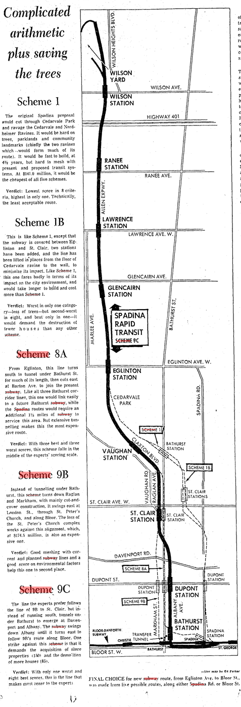
Twyn Rivers Drive is a curious street in the eastern fringes of Toronto. In a larger metropolis where farms and fields have been replaced by residences and populations, Twyn Rivers Drive is slightly rural in nature and still has visible links to its past.

Twyn Rivers Drive, 2020. Source: Google Maps

Country within The City

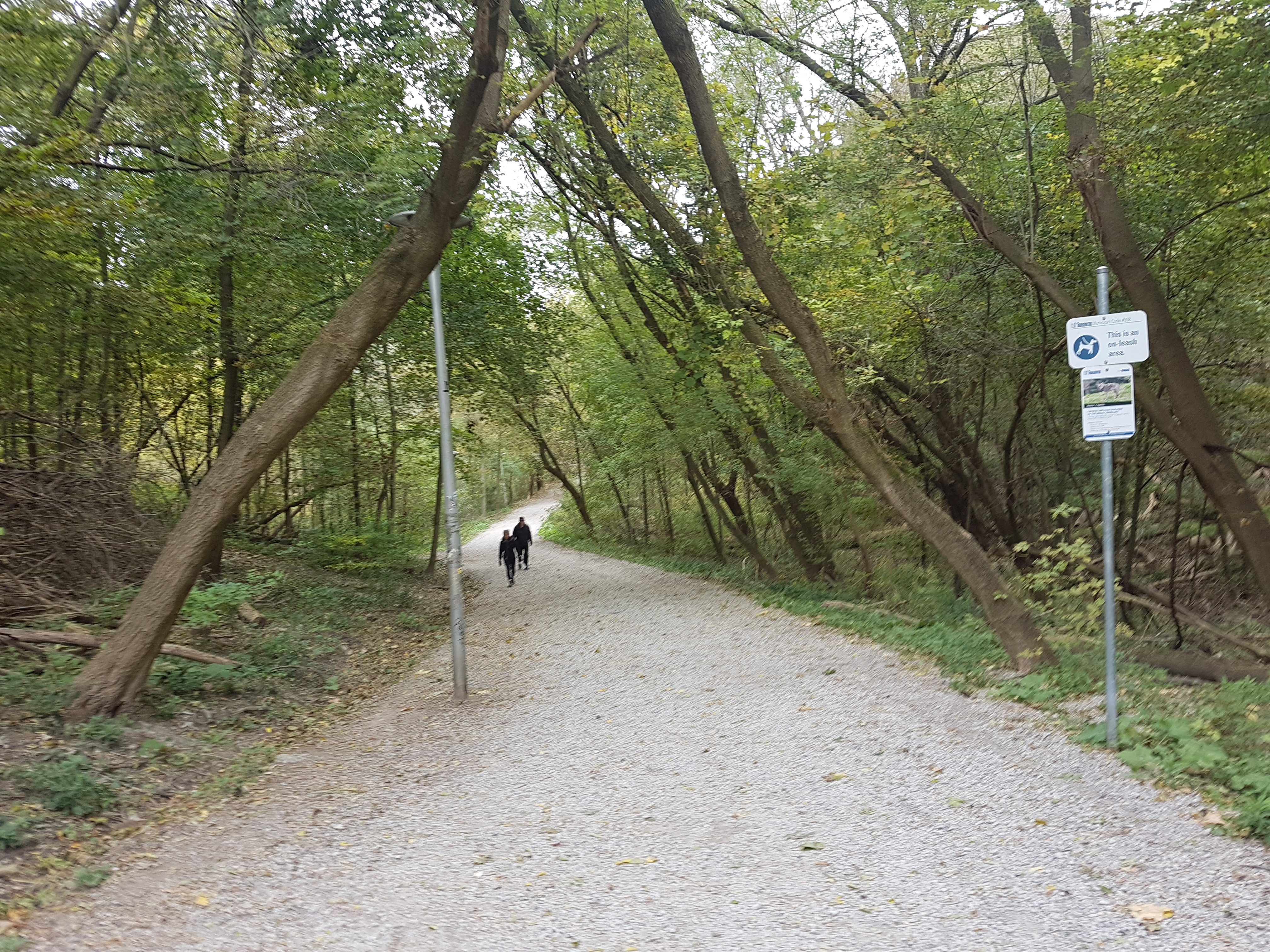
Located in the Rouge River Valley, Twyn Rivers Drive’s rural character is very well apparent. First, it’s a two-lane street lacking any sidewalks. Motor vehicles, bicycles, pedestrians, and even wildlife all have to carefully negotiate use of the street. Like some country roads, Twyn Rivers’ route across the valley is not direct. There are slopes, curves, and two near 90 degree turns. It has to navigate what may be the most varied topography in the city. Its path starts with a winding descent from Scarborough’s Sheppard Avenue and eventually on the other side on Sheppard Avenue…in Pickering.

Twyn Rivers Drive, 2018. Source: Google Maps.
Twyn Rivers From The Pleistocene of the Toronto Region, 1932. Source: University of Toronto Map & Data Library.

A History of Twyn Rivers Drive

The historical beginnings of Twyn Rivers Drive is an obvious question, but unfortunately, it does not have an obvious answer. It is old for sure. A September 2017 City of Toronto Traffic Operations Review characterizes Twyn Rivers Drive as “a legacy road from colonial times” and speculates that it is about 200 years old. A June 2017 CBC article says Twyn Rivers Drive is “more than 100-years old” and its main purpose was to get horses to the mills in the valley. Neither report provide any historical context to back up the claims. Twyn Rivers Drive seems to first appear in a 1916 map of Toronto and its surrounding townships, so a hundred years may be accurate at the least.

Twyn Rivers from Map of the Townships, York, Scarboro, and Etobicoke, 1916. Source: University of Toronto Map & Data Library

The naming of Twyn Rivers Drive likely also goes back to its geography. It possibly derives from the Clarence Purcell’s ‘Twyn Waters’ ranch located in the Rouge Valley on what is now Twyn Rivers Drive. The twin rivers in this case are the famed Rouge River and its lesser known brother, the Little Rouge Creek. It is unknown when Twyn Rivers Drive was actually named, but the Twyn Waters ranch existed by the 1930s.

“Picnikers Enjoy Western Hospitality,” Globe and Mail, July 6, 1939. Source: Toronto Public Library and Globe and Mail Archives.
Twyn Rivers Drive in Might’s Greater Toronto city directory, 1969. Source: Toronto Public Library.

Two Rivers, Two Bridges

Twyn Rivers Drive travels over two bridges over the mentioned waterways. The first of these over the Rouge River is a single-lane, metal truss construction. It is named “Stott’s Bridge“. Few details are available about the age and origin of this bridge, but it seems to share a surname with William Stotts, who had his estate house, Glen Eagles Manor, further up the hill at the modern junction of Twyn Rivers Drive and Sheppard Avenue East. The house later became the Glen Eagles Hotel.

Stott’s Bridge, 2019. Source: Google Maps.
William Stotts from Nason’s east and west ridings of the county of York or townships of Etobicoke, Markham, Scarboro’, Vaughan & York directory, 1871. Stott’s property was located on Concession 2 (now Ellesmere Road), on north half of lot #3. He is listed as a freeholding farmer. Highland Creek likely denotes the post office Stotts used. Source: Toronto Public Library.
Twyn Rivers From Tremaine’s Map of the County of York, Canada West, 1860. Source: Old Toronto Maps.

The second causeway is a white arched bridge over the Little Rouge Creek. “Maxwell’s Bridge” is a concrete structure which accommodates two lane traffic. It is at least the second or possibly third version of a water crossing in this location. An antique wooden bridge collapsed in 1914 after a heavy vehicle passed over it. A new bridge was soon ordered to be built. In 1927, Scarboro Township Council funded the construction of a new rainbow arch bridge with a 60-foot span at a cost of $7,797. Several other arch bridges were built in the Nineteen Tens and Nineteen Twenties Kirkham’s Road over the Rouge River in 1910, Don River Boulevard over the West Don River in 1928, and Don Mills Road over the Don River in 1921.
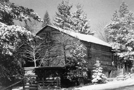
“Antique Bridge Collapses”, Toronto Daily Star, August 7, 1914. Source: Toronto Public Library and Toronto Star Archives.

“BRIDGE AT KIRKHAM’S MILLS”, Globe and Mail, September 13, 1910. Source: Toronto Public Library and Globe and Mail Archives

Maxwell’s Mill

Nearby Maxwell’s Bridge where Twyn Rivers Drive does its second bend are the ruins of a grist mill named “Maxwell’s Mill”. The site was built by a James Maxwell in the 1800s. In 1923, Maxwell sold it to Clarence Purcell who used it to raise livestock on his Twyn Waters ranch.

Twyn Rivers from Illustrated Historical Atlas of the County of York, 1878. Maxwell’s Mill is the Grist Mill labelled on his lot. Source: Old Toronto Maps.
James Maxwell from Nason’s east and west ridings of the county of York or townships of Etobicoke, Markham, Scarboro’, Vaughan & York directory, 1871. Maxwell is listed as a flour mill freeholder with a Post Office at Rouge Hill. His plot of land was located at Concession 3 (now Sheppard Avenue) on lot #2. Source: Toronto Public Library.
MEN OF TREES FAIR AT ‘TWYN WATERS’, Globe and Mail, September 24, 1941. Source: Toronto Public Library and Globe and Mail Archives.

The mill closed in 1929 after a flood weakened it and a fire in the 1970s destroyed much of what remained. Some of the foundations and walls still stand today. An image of Maxwell’s Mill is available on the Scarborough Historical Society’s website.

Mill stone at the Rouge river Twyn River Estate. Toronto, Ont., 1957. Source: Toronto Public Library

The Rouge Valley Inn & Caper Valley Ski Hill

The Rouge Valley Inn (later called the Rouge Valley Olympic Inn) was located on the south side of Twyn Rivers Drive slightly before the Scarborough-Pickering Townline. The site was a major Scarborough attraction in the twentieth century with a hotel, dining, picnicking for families, and “the largest swimming pool in Ontario.” Ambrose Small, the 20th century Ontario theatre titan who mysteriously disappeared in 1919, owned the Rouge Valley Inn for a time starting around 1900.

“Everyday Outings”, Globe and Mail, June 25, 1958. Source: Toronto Public Library and Globe and Mail Archives.
“Rouge Valley Guests” Globe and Mail, August 9, 1940. Source: Toronto Public Library and Globe and Mail Archives.
“$500 Reward,” Toronto Daily Star, January 6, 1920. Source: Toronto Public Library and Toronto Star Archives.

Across the Little Rouge Creek from the Rouge Valley Inn was the Caper Valley Ski Slope, also known as ‘Snake Hill’ for those who used to frequent it. Along with Earl Bales Park and other establishments, it was one of a handful of areas in Metro Toronto that offered the winter passtime. It was operated by Repac, whose name spelled backwards gave the ski hill its moniker. A footbridge linked the inn and the ski slope.

“School children taper at weekly ski outing”, Globe and Mail, January 6, 1972. Source: Toronto Public Library and Globe and Mail Archives.
Caper Valley Ski Hill, 1975. Source: Toronto Public Library.

Twyn Rivers Transformed

By the end of the 1970s, much of the historic landmarks of Twyn Rivers Drive disappeared from its geography. Fire claimed both the Rouge Valley Inn in 1968 and Maxwell’s Mill in 1970. The former site of the hotel is now the parking lot for the Twyn Rivers Rouge Park area. The mill’s ruins make for an interesting place for urban explores. Clarence Purcell sold his Twyn Waters ranch to the Metro Toronto and Region Conservation Authority in 1970, which after Hurricane Hazel in 1954 began to buy other valley and ravine properties for parkland. Today, there are very few residences located in Rouge Valley.

Twyn Rivers Drive, 1953 & 1975. Source: City of Toronto Archives.

By 1973, the Caper Valley Ski Hill was reporting financial difficulty and it too closed by the end of the decade. It now makes for challenging hike in Rouge Park’s Mast Trail. Finally, the Glen Eagles Hotel was also destroyed by fire in 1990, and is now the Glen Eagles Vista park. The site was nearly made condos. Today, most of these are owned and/or managed by Parks Canada.

Glen Eagles Hotel Fire, 1990. Source: Toronto Public Library.

Twyn Rivers Today

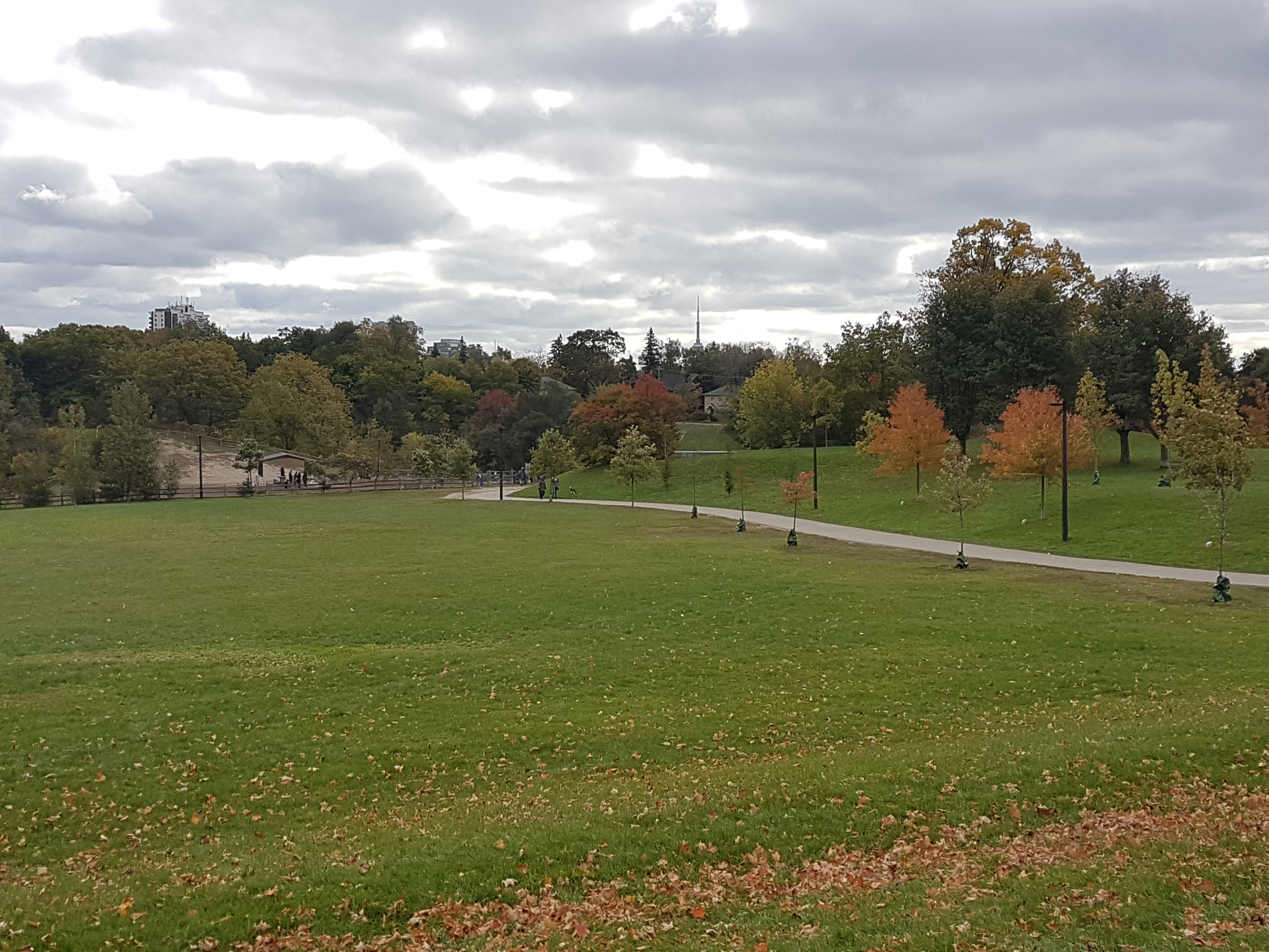
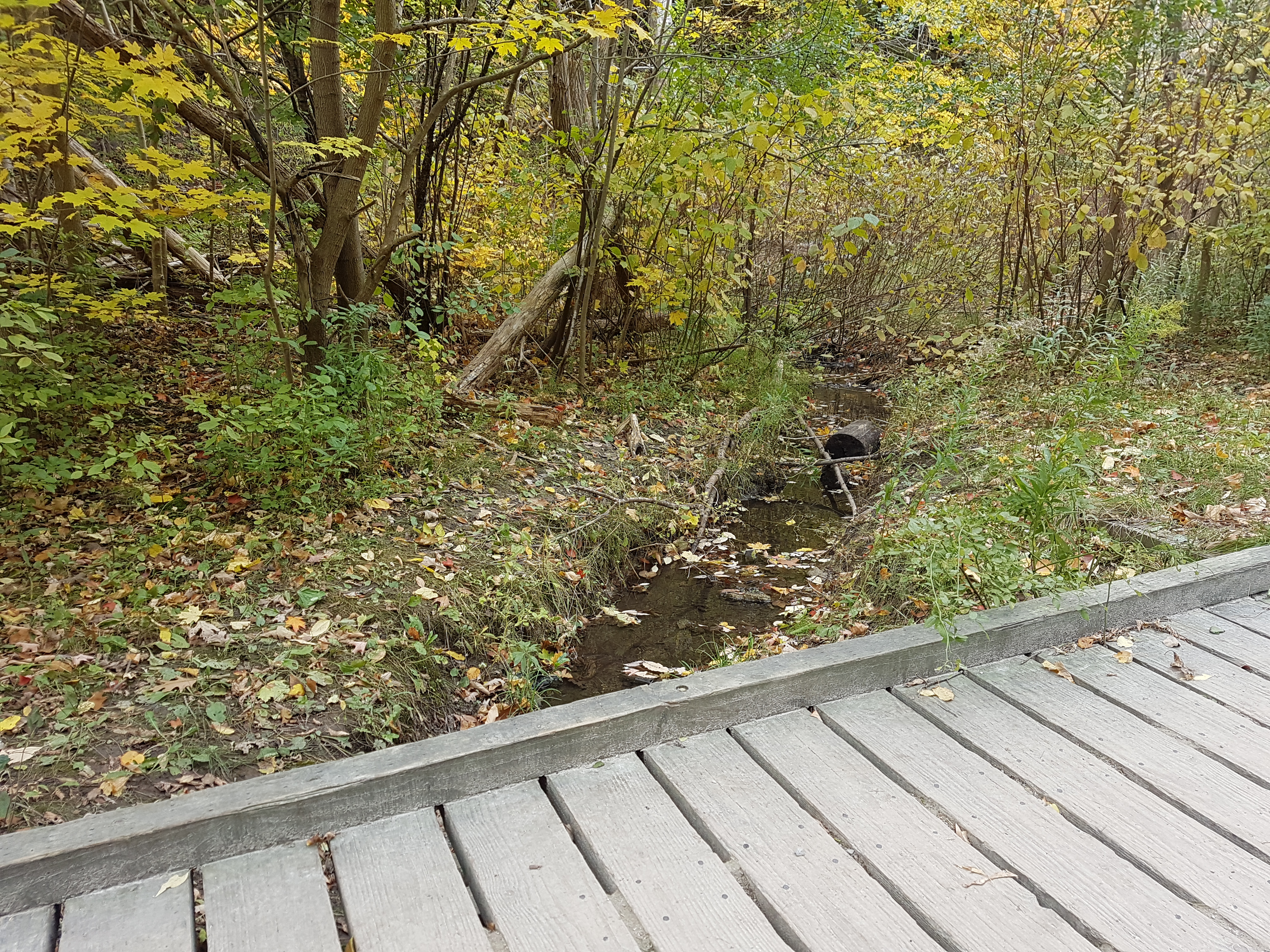
Today, Twyn Rivers is quite the nexus for Rouge National Urban Park, being the starting and ending point of multiple trails. The first source of exploration can be enjoyed around the Rouge Park parking lot. The area is situated on the Little Rouge Creek where the foundations of a former dam still stand. A makeshift footbridge crosses the creek where one can walk in the lost tracks of skiers on Snake Hill.

The Orchard Trail

Near Maxwell’s Mill is the southern terminus of the Orchard Trail. The two-kilometre walk slinks within the forest where apple trees grow today. It also offers vistas of the Little Rouge Creek. A particularly stunning area is the ascent/descent near the north end of the trail.

References

clay70, et al. Purcell’s Mill – Twyn Rivers. www.ontarioabandonedplaces.com/Purcell’s-Mill—Twyn-Rivers-abandoned-Ontario_loc5901.html.

Hikingthegta. “Maxwell’s Mill – Rouge Park.” Hiking the GTA, 24 Nov. 2016, hikingthegta.com/2016/11/23/maxwells-mill-rouge-park/.

Noonan, Larry. “STORIES FROM ROUGE PARK: Hurricane Hazel Also Blasted Rouge Valley.” Toronto.com, Toronto.com, 7 June 2016, www.toronto.com/news-story/6709710-stories-from-rouge-park-hurricane-hazel-also-blasted-rouge-valley/.

Noonan, Larry. “STORIES FROM ROUGE PARK: Recalling the Time the Glen Eagles Lands Were Saved from Condo Developers.” Toronto.com, Toronto.com, 4 June 2015, www.toronto.com/news-story/5661631-stories-from-rouge-park-recalling-the-time-the-glen-eagles-lands-were-saved-from-condo-developers/.

Noonan, Larry. “STORIES FROM ROUGE PARK: Rouge Valley Inn’s Owner Was the Subject of Canada’s Largest Manhunt.” Toronto.com, Toronto.com, 2 July 2015, www.toronto.com/news-story/5705937-stories-from-rouge-park-rouge-valley-inn-s-owner-was-the-subject-of-canada-s-largest-manhunt/.

Noonan, Larry. “STORIES FROM ROUGE PARK: The Ruins of Maxwell’s Mill Can Still Be Seen While Driving along Twyn Rivers Drive in Scarborough.” Toronto.com, Toronto.com, 31 Dec. 2015, www.toronto.com/news-story/6214521-stories-from-rouge-park-the-ruins-of-maxwell-s-mill-can-still-be-seen-while-driving-along-twyn-rivers-drive-in-scarborough/.

Parks Canada Agency, Government of Canada. “Twyn Rivers Area.” Twyn Rivers Area – Rouge National Urban Park, 12 Apr. 2019, www.pc.gc.ca/en/pn-np/on/rouge/culture/histoire-history/twyn.

“Pickering Bygone Days.” DurhamRegion.com, 5 May 2015, www.durhamregion.com/community-story/5600442-pickering-bygone-days/.

Scarborough Historical Society, scarboroughhistorical.ca/local-history/communities/hillside/.

“Toronto’s Ravines and Urban Forests.” Google Books, Google, books.google.ca/books?id=2Q37CAAAQBAJ.

“Who Should Use This 100-Year-Old Scarborough Road? Not Trucks, Says Resident | CBC News.” CBCnews, CBC/Radio Canada, 19 July 2017, www.cbc.ca/news/canada/toronto/twyn-rivers-drive-what-should-happen-1.4212333.

Scenes From Cedarvale

Cedarvale lies northwest of the intersection of Bathurst Street and St. Clair Avenue West in the old City of York. At the centre of its story and its geography is its parkland. All that surrounds is just as interesting.

Cedarvale, 2018. Credit: Google Maps.

Mappy beginnings

The history of Cedarvale begins with lots 26 and 27 of Concession III west of Yonge Street from the old lot system. The third concession road is now the mentioned St. Clair West with the 200-acre lots extending north to the fourth concession (Eglinton Avenue) just west of present Bathurst Street.

Tremaine’s Map of the County of York, Canada West, 1860. Credit: Historical Maps of Toronto.

Lot 27 first appears in Toronto maps as belonging to the Estate of James Brown. It then passed to John Roach. Lot 28 belonged to a John Severn and then to a Mr. Davidson. The 1899 and 1903 editions of the Goads Fire Insurance Maps show brick fields near Markham Street (today’s Raglan Avenue) which are gone by 1910. Flowing diagonally through the plots was Castle Frank Brook, making brick manufacturing a possibility. The stream was also known as Brewery Creek or Severn Creek, as it is the same waterway that aided the Severn Brewery in Yorkville. It is unclear if the brewer and the land owner are the same, but it is notable their given names do match. By the 1910s, the plots appear under the name of Sir Henry Pellatt of Casa Loma fame.

Illustrated Historical Atlas of the County of York, 1878. Roach Street within the modern community (now Strathearn Street) was named for John Roach and falls within his former borders. Credit: Historical Toronto Maps
Map of the Townships, York, Scarboro, and Etobicoke, 1916. Credit: University of Toronto Map & Date Library.

A New Subdivision

Situated up Bathurst at Claxton Boulevard is the first curiousity about this unique area: the Connaught Gates. Dating to 1913, they hide an ambitious past.

Beginning in June 1912, advertisements in The Toronto Daily Star and The Globe newspapers promoted a new exclusive suburb named Cedarvale (or Cedar Vale) in the area south of Eglinton Avenue, north of Vaughan Road, and west of Bathurst Street. The company behind the new 300-acre subdivision was The British and Colonial Land and Securities Company, which was Sir Henry Pellatt’s realty firm. Pellatt’s interests were in land accumulation and speculation. The sales pieces marketed Cedarvale’s tree-lined streets including a neighbourhood-spanning central boulevard and a natural beauty even surpassing Rosedale in the form of Cedarvale ravine. Interested parties were to contact Robins Real Estate Limited for an illustrated booklet.

Cedarvale ad, Toronto Daily Star November 8, 1912. Credit: Toronto Public Library
Cedarvale ad, The Globe, June 7, 1913. Credit: Toronto Public Library.

Contextually, Cedarvale’s emergence came at a time in the early 20th century when civic discussions revolved heavily around the growth of the city of Toronto and its surrounding areas. Annexations of neighbouring St. Clair Avenue communities of Wychwood and Bracondale in 1909 and Dovercourt and Earlscount in 1910 increased the city’s borders. In the following year, the Toronto Civic Railways opened a transit line along St. Clair, effectively turning those communities into streetcar suburbs and spurring development. Cedarvale – which took advantage of the new streetcar in their new promotional pieces – joined these discussions of annexation, which included a November 1912 meeting of Pellatt, John Gibson, and other investors with Toronto mayor Horatio Hocken. Although the benefits of extending city services like sewers and police and fire protection were discussed, Cedarvale ultimately stayed in the Township of York, not joining Toronto until the mega-city amalgamation in 1998.

“Cedarvale Annexation”, Toronto Daily Star, July 3, 1914. Credit: Source: Toronto Public Library.
Map of the township of York, 1923. Credit: Toronto Public Library.

The original vision of Cedarvale centred around Connaught Avenue. From the gates at Bathurst, the street travelled northwest, passing through the Connaught Circle roundabout. It then spanned over the valley with the mighty Connaught Bridge. The bridge was important in connecting the upper and lower parts neighbourhood, an affinity still valued today. From here, Connaught spilt into east and west sections, surrounding a diamond island of gardens, finally terminating at Eglinton. Surrounding streets, including one named Pellatt Crescent, fed into the Connaught Gardens. Ravine Drive followed the valley below with lots for purchase. Running adjacent was a trail as well as a lake and tennis courts which could be accessed from the path or via stairs from Hillbrow and Roach Street (Heathdale and Humewood Street today). They would have been located where the Cricket Field and Phil White Arena stand today.

Map Of Cedarvale, Township of York, 1913. Credit: Toronto Public Library.

Cedarvale/Connaught Bridge (now Glen Cedar Bridge), 1915. By 1973, the bridge was unsafe for vehicular traffic and was made into a pedestrian-only bridge. Debate swirled in the 1980s over safety and potential heritage status, and the bridge was ultimately replaced in 1989. In 2018, the bridge was again revitalized with replacements stairs spanning from the valley floor up to the bridge. Credit: City of Toronto Archives.

By the 1930s, maps show a street grid which curiously deviates from the original vision, looking closer to the present-day neighbourhood. Connaught Gates and Connaught Circle still showed, but Connaught Gardens disappeared from the grid. The street was also renamed Claxton Boulevard and Glen Cedar Road, north and south of Connaught Circle respectively. It is notable here that Sir Henry Pellatt himself went bankrupt in 1923 after some shady dealings of buying land and borrowing money, and the street baring his name failed to exist.

Might’s clearview correct city directory map of Greater Toronto, 1930. Credit: University of Toronto Map & Data Library.

Development in the 1930s to 1950s

Cedarvale’s streets began to modernize in the 1930s as its population grew and changed, and the city’s geographies necessitated better connectivity. Housing south of the valley had developed in the 1920s, but north of the valley, development stalled. As a point, Glen Cedar Road was not built on at all in 1930. The answer to this: A new $250,000 bridge opened on Bathurst Street on August 6, 1930, replacing an earlier muddy construction over Cedarvale Ravine. The move opened the entire area for development in the 1930s, ’40s, and ’50s.

Cedarvale ad, The Globe, September 14, 1929. Credit: Toronto Public Library.
Bathurst Street, looking north from Lonsmount Avenue, 1900-1954. Credit: Toronto Public Library.
Cedarvale’s empty streets, Might’s Directory, 1930. As seen the above map from this issue, Cedarvale is part of the Wychwood District. Credit: Toronto Public Library.
Cedarvale & Forest Hill, 1935. Bathurst Street and its new bridge are at the centre of the image. The north part of Cedarvale filled out by 1950. Source: City of Toronto Archives.

A specialty to York Township, which lacked the building restrictions of Toronto, Bathurst Street between St. Clair and Eglinton Avenues became a sort of ‘apartment row’ in the inter-war years, providing the home to new residents. Architect Victor Llewellyn Morgan designed a few of these walkup lofts, including the 1931 Claxton Manor. Wordsmiths Northrop Frye and Ernest Hemingway also famously resided in Bathurst Street lofts.

By the 1950s, the Jewish community also moved north from downtown Toronto. The Goel Tzedec Congregation, whose synagogue was situated on University Avenue, looked to Bathurst Street North for a new site. Despite community opposition, York Township Council had approved the erection of a place of worship in September 1949. After a merger with the Beth Hamidrash Hagadol Congragation, Beth Tzedec Synagogue was dedicated on December 9, 1955.

“Rap Synagogue For Cedarvale”, Globe and Mail, Nov 25 1947. Credit: Toronto Public Library.
Site of Goel Tzedec Synagogue, 1951. Credit: City of Toronto Archives.

Cedarvale Ravine

With numerous access points, Cedarvale Park is well connected to the neighbourhood as it was originally intended. The space itself can be thought of in two sections. To the north, there is an open field area with panoramic views to the downtown Toronto skyline.

To the south, the park is a more wooded and wetland area with the overhead sights of valley-backing houses and the towering bridges of Glen Cedar and Bathurst. Castle Frank Brook also makes its appearance here, albeit briefly. In the 1910s, one could witness military demonstrations in the valley; in the 1920s, Ernest Hemingway is said to have meandered its grounds. But as much as Cedarvale Ravine is about the beauty all around, its story is as much about what is underneath — and what might have existed above.

Cedarvale, 1914. Credit: City of Toronto Archives

Spadina Subway/Expressway

Talk of a northward extension of Spadina Road began in the 1950s with formal plans by the Ontario Government announced in the 1960s. In June 1971, after serious community opposition, Ontatio Premier William Davis cancelled the controversial Spadina Expressway, halting construction at Lawrence Avenue. This threw rapid transit plans up in the air, specifically the Spadina subway that would have ran along the highway. Since a highway would not happen, the route of the subway fell under debate. Under the original plans, the subway would have run from Downsview Airport through the ‘Spadina corridor’ south to Eglinton and then through Nordheimer and Cedarvale Ravines to Spadina Road, where it would join with Bloor Street at St. George Station. A new proposal favoured a route under Bathurst Street to the Bloor-Danforth Subway.

“New Subway Proposal”, Toronto Star, January 6, 1972. Credit: Toronto Public Library.

Metro Toronto Council established a task force to determine its possibilities. The task force analyzed more than 10 possibilities and narrowed it down to 5 final routes. Two of the routes were variations on the original Spadina corridor; the other three followed Bathurst Street. All five designs recommend leaving the portion from Wilson Station to Eglinton untouched.

The ‘winning proposal’ had the subway cutting under Cedarvale ravine, then under Claxton and Raglan Avenues, under Bathurst, then south on Albany to Bathurst station, then bypassing Spadina Station to join with St George. It was chosen because of the possibilities to extend the subway south of Bloor to join Queen and to the waterfront. The downsides though were the requirement of acquiring 150 more properties and the demolition of 85 more houses, and would require construction on Bathurst.

“Final Choice”, Toronto Star, January 12, 1972. Ranee Station is today’s Yorkdale Station. Note the station under the Spadina alignment at Bathurst and Heathdale. Credit: Toronto Public Library.

Proponents of the Spadina Expressway opportunistically favoured the original alignment because it meant that the Expressway could be added later. The borough of York – and the Cedarvale community specifically – did not favour either for the damage it would do to the ravine and for the expropriated properties. Preparations in 1971 had already interrupted recreational activities in the park. Debate continued into 1972. The Spadina line was a much needed relief line for the Yonge subway, which, even though was set to extend to York Mills from Eglinton in 1972 and to Finch in 1973, was at capacity. A decision was needed.

“Ten Citizens set out to rescue our ravines”, Toronto Star, June 10, 1972. Credit: Toronto Public Library.

Finally in January 1973, Premier Davis announced that it would fund 75% of the cost of the subway. It was up to Metro to decide the route of the subway. Council voted in favour of the Spadina alignment for its lower cost and construction time. The Borough of York agreed to support the subway under the grounds that the proposed Bathurst station at Heathdale would be nixed.

“The Spadina Route”, Toronto Star, January 19, 1973. Credit: Toronto Public Library.

Toronto City Council opposed the vote and opted to appeal to the Ontario Municipal Board to have it changed to the Bathurst alignment. It actually announced that it favoured a third route to the west, but if forced to choose, Bathurst was it. During the hearings, another proposal came onto the table from William Kilbourn to follow the Canadian National Railway. Nonetheless, construction on the transit line began in 1975 with the line opening from Bloor to Wilson in 1978 with two stations at Eglinton and St. Clair serving the Cedarvale area. The cancelled station at Heathdale explains long distance between stations.

Cedarvale, 1975. Note the cut and cover method of tunnel building. Credit: City of Toronto Archives.

Within Cedarvale Park, an emergency entrance at Markdale provides an obvious door into what lies below, but the rumblings of the subway are masked by the replenished canopy and wetland (albeit, the ravine like others in Toronto faces ecological collapse).

At Heath Street, one ascends out of Cedarvale Park near the north entrance of St. Clair West Station. Below, Castle Frank Brook continues under the subway station towards Nordheimer Ravine, leaving behind an area with layered history.


Useful Links

BlogTO – “A Brief History Of Castle Frank Brook, The Ravine Carver” by Chris Bateman

City of Toronto Archives – “A Work in Progress: Landscape Architects and Building Trades”

Discover The Don – “What Was Brewery Creek?”

Friends of Cedarvale

Globe & Mail – “Got a Gate” by John Lorinc

Jay Young – “Searching For A Better Way: Subway Life And Metropolitan Grown In Toronto, 1942-1978”

Lost Rivers – “Cedarvale Ravine”

Spacing – “The fall of Sir Henry Pellatt, king of Casa Loma” by Chris Bateman

Till Next We Trod The Boards – “Toronto’s Heritage Apartments”

Toronto Dreams Project – “Casa Loma & The Crooked Knight”

Toronto Star – “Ghosts of Spadina Expressway Haunt Us Still” by Shawn Micallef

Transit Toronto – “The Spadina Subway” by James Bow

Urban Toronto – “A Pictorial History Of Toronto’s Cedarvale Neighbourhood” by Edward Skira
Wayne Reeves and Christina Palassio – HTO: Toronto’s Water from Lake Iroquois to Taddle Creek and Beyond

Scenes From York-Durham Heritage Railway

The York-Durham Heritage Railway (YDHR) was established in 1987, but as its name suggests, the history stretches beyond. Making use of a discontinued rail line between Uxbridge and Stouffville, the entirely volunteer-run organization offers seasonal weekend train rides between the towns.

The YDHR operates out of Uxbridge, using its 1904 train station as a tiny railway heritage museum. The structure is distinct for its ‘witch’s hat’ roof. At one time its waiting rooms drew would-be rail travelers. Today, the station houses railway artefacts inside and an impressive stock of engines and cars outside. Of note is a passenger car of the Ontario Northlander.

The selection of Uxbridge as the YDHR’s headquarters is appropriate as the Toronto & Nippissing (T&N) Railway housed their main yards there. The T&N Railway established the rail line in the 1860s. George Gooderham was a main investor who used the line to bring raw materials from Ontario’s northern reaches to the Gooderham & Worts complex on the Toronto waterfront. In 1871, a ceremony opened the line in Uxbridge.

Map of the Township of Uxbridge, 1877. The Township was once part of Ontario County which merged with other local counties to create the Regional Municipality of Durham. Source: Canadian County Altas Digital Project.
Gooderham & Worts, Ltd., Toronto., 1896. Source: Toronto Public Library.

Uxbridge itself is a suburban town which retains its 19th charm. It is perhaps most famed for the mausoleum of Thomas Foster, a Toronto mayor from 1925-1927, which was inspired by a trip to India.

The YHDR’s main train is the 1956 Locomotive 3612, complete with dining and bench seating passanger cars for a relaxing trip and an open-window snack/baggage car for a more scenic opportunities.

The Fall Colours Train showcases the diverse landscapes of forests, farm fields, golf courses, and gravel pits of the Oak Ridges Moraine (ORM), an environmentally protected and sensitive corridor north of Toronto between Caledon and Peterborough. Elevation in ORM reaches as high as the CN Tower.

The Town of Goodwood is the mid-way point of the trip. At one time the T&N Railway served it; its station now replaced with GO bus transit. Interestingly, Goodwood doubles as the TV town of Schitt’s Creek. Just south and west in Licolnville, the train crosses into York Region.

Stouffville too is a train town. While the current GO station dates to 1995, the arrival of the Toronto & Nippising Railway brought the first station on south of Main Street to the town. It in turn spurred commercial and industrial development.

A brief history includes town founder Abraham Stouffer settling here in 1804, naming the hamlet “Stoufferville”, which was later shortened. Along with the Toronto & Nipissing Railway, there was also the Lake Simcoe Railway running to Sutton, Ontario, making Stouffville into a railway junction.

Map of the Township of Whitchurch, 1878. Note the lands around Stouffville belonging to the Stouffer family. Source: The County Atlas Digital Project.

After financial difficulties which saw the T&N railway transferring between rail companies, the Canadian National Railway eventually came to own the line in 1920. Northerly sections of track fell out of use gradually through the 20th century. Today, the original T&N right of way transports passengers through the Stouffville Go Line, passing through stations at Markham, Unionville, Agincourt, and Scarborough. Whereas a small station in the Distillery District once served as the the southern terminus, Union Station expectedly takes that spot today. The York-Durham Heritage Railway began operations in 1996. Metrolinx still owns the YDHR track and is considering returning service to Uxbridge.


Useful Links

Rails Across Ontario: Exploring Ontario’s Railway Heritage by Ron Brown

Stouffville Sun-Tribune – “From 75 inhabitants to 45,000; a brief history of Whitchurch-Stouffville”

Torontoist – “History is Fun! Toronto’s Mayors in Short” by Patrick Metzger

Transit Toronto – “GO Transit’s Stouffville Line”

Scenes From East Don Parkland

It’s all about the layers in the East Don Parkland. The residual landscape from the last Ice Age, the ravine, which stretches from Leslie and Steeles to Don Mills and Sheppard, has come to see pre-contact wilderness, colonial farming and industry, and post-war revitalization and reconfiguration.

But ‘East Don Parkland’ is a bit of a misnomer if only because it encompasses not only the east branch of the Don River but another – albeit smaller – tributary waterway.

German Mills Creek originates just to the north of Steeles in its historic namesake Markham community (sadly, now lost). The label is pretty literal, too: German Mills was once an industrious village along John Street founded by Bavarian-born William Berczy and a group of his countrymen and women. In addition to being a prosperous settlement, the community was instrumental in the early development of York too. The goods supplied by the mills aided in constructing the actual built form of the young town. The German Mills pioneers also cleared Yonge Street from Eglinton to Thornhill before the Queen’s Rangers finished the job.

East Don Parkland became part of Toronto’s parks network in the 1980s after efforts to remediate and rehabilate a river that had been worn out by European activity. Today, it is home to a number of flora and fauna, most notably salmon and white-tailed deer, the latter which are prominently displayed on the park’s signage. A neat tidbit: the deer’s precense in Toronto dates back to around 9000 years after the end of the last Ice Age.

Cummer Avenue bisects (or trisects?) East Don Parkland and offers more history. Unsurprisingly, the street’s name plays homage to the family who toiled around and built it – although to different designs.

Jacob and Elizabeth Kummer (the name was inexplicably changed to a ‘C’ around 1820), like the pioneers of Markham were of German descent, and came to the Toronto area in 1795, first settling near Yonge and Eglinton. They would relocate further up the main street to Willowdale where they would amass an extraordinary fortune. Their original property was a 190-acre lot fronting Yonge and stretching to Bayview. With subsequent generations of Cummers, their holdings grew to encompass not only large plots fronting Yonge but portions of the East Don Valley too. Whereas the former real estate was good for farming and commercial activities, the power of the river allowed the Cummers to engage in some industry. In 1819, they built and began operating a sawmill.

The Don property was interestingly significant in that early settlers as well as First Nations peoples took part in church and camp activities there. Through the meetings, the area was famously known as “Scripture Town” and “Angel Valley”.

East Don from Tremaine’s Map, 1860. Source: Toronto Historic Maps.

Around the 1850s, Jacob III, grandson of Jacob Kummer, built a farmhouse to overlook the valley. The home isn’t perfectly parallel to the street it rests on, making it a bit of an intriguing anomaly with the surrounding post-war subdivision.

To connect the Cummers’ Yonge and East Don holdings, a side road was constructed. Today, we know that road allowance as Cummer Avenue. Where the street crossed the East Don, it veered south to follow the curve of the river on its way to Leslie Street. The aforementioned mill was also located near this junction.

East Don River and Old Cummer, 1950. Source: City of Toronto Archives.

In the mid-1960s, Cummer was re-oriented away from the valley. A bridge that used to carry car traffic across the river serves as a reminder of its former course. One has to think of the vehicular ghosts when traversing the recreational trail that replaced the street.

A paved portion also leads to Old Cummer GO Station, where the street once passed through before the station’s construction in 1978. For years I puzzled about the station’s name. 

South of Finch Avenue, with golden foliage of fall to accentuate the walk, the trail winds on. 

So does the river, although not as it once did. Like Cummer Avenue, the Don’s history has come with some alterations. Along the way is at least one algae-covered oxbow – an orphaned or even ghost segments separated from the river’s course. This particular one was severed around the early 1950s.

East Don River, 1950. Source: City of Toronto Archives.
East Don River oxbow, 1965. Source: City of Toronto Archives.

One has to note the monstrosity of human construction that is the CNR Richmond Hill GO line looming above the park.

A fallen tree trunk spanning across the river instantly urges me of more pioneering connections. It reminds me of an Elizabeth Simcoe depiction of an early bridge across the Lower Don River.

Winchester Street, bridge over Don R. (Playter’s bridge), 1794. Source: Toronto Public Library.

Finally, at the park’s southern end is Old Leslie Street. Just like Old Cummer, Leslie used to take on a different route. Heading south, the street used to jogged west at Sheppard before continuing south, all presumably to avoid crossing the Don River.

Sheppard and Leslie, 1961. Source: City of Toronto Archives.

The junction of Old Leslie and Sheppard was the nexus of the tiny, lost mill community of Oriole, named for George S. Henry’s homestead located off the Betty Sutherland Trail

Old Leslie Street and Sheppard, 1956. Source: Toronto Public Library. Oriole Wesleyan Methodist Church stood on the southwest corner from 1873 to the 1950s.

By 1969, the street was rerouted directly through Sheppard. Old Leslie remains mainly as a service road for the Leslie TTC Station, terminating across from North York General Hospital.

Useful Links

City in the Trees – Retrospective: Sheppard, Leslie, and the Don

Discover the Don – Walk The Don – East Don Parkland 

City in the Trees – Treasures on the Doorstep

Hiking The GTA – Old Cummer Road 

Lone Primate – Closed Old Cummer Avenue

Patricia W. Hart – Pioneering in North York: A History of the Borough

Richard Fiennes-Clinton – Muddy York: A History of Toronto Until 1834

Scott Kennedy – Willowdale: Yesterday’s Farms, Today’s Legacy 

Scenes From The Scarborough Bluffs

The Scarborough Bluffs are Scarborough’s claim to fame and claim to name. Although the southern part of borough and its winding main streets are another world to me personally, I know that in the general consciousness of Torontonians, the Bluffs usually come up in Scarborough word association. Or, at least, they should.

The built form of the southern end of Scarborough is a result of the Bluffs, including Kingston Road, whose course roughly follows the top of the landform. Laid out in 1817, it is one of the oldest European routes in the borough. In a pre-401 world, Kingston Road was the highway in and out of Toronto from the east. Its existence made it ideal for hotels and inns to aid travelers in their voyages. Some motels still dot the street today.

Map of the Townships, York, Scarboro, and Etobicoke 1916
Map of Scarborough Township, c. 1916. Source: University of Toronto Map & Data Library.

Half-Way House, Kingston Road. - [1920?]
Halfway House, Kingston Road & Midland Avenue, c. 1920. The building is currently situated at Black Creek Pioneer Village. Source: City of Toronto Archives.
One notable landmark near Birchmount Road is not a rest stop but Scarborough Arts. The non-for-profit arts organization has a mandate “to create and cultivate innovative arts and cultural programs in Scarborough.” It’s a good one.

Scarborough Arts 1

In addition to facilitating and promoting artistic programs, Scarborough Arts also has rotating exhibition space, appropriately named the Bluffs Gallery. In March 2016, its showcase was ‘YEARBOOK’, a brilliantly-conceived and -executed exhibit which utilized high school yearbooks to tell Scarborough’s history and its remarkable demographic change in particular.

Scarborough Arts Yearbook 1

Scarborough Arts Yearbook 3

It’s not a surprising discovery, but Scarborough didn’t begin to really diversify until around the 1980s. In addition to offering demographic snapshots, I enjoyed the cultural tidbits that could be gleaned from the yearbooks, such as what kind of school clubs existed and the advertisements of local businesses of the day.

Scarborough Arts Yearbook 4
Agincourt Collegiate Institute yearbook, 1964. I attended and graduated from the school some 50 years later.

Scarborough Arts Yearbook 5             Scarborough Arts Yearbook 12

The Scarborough Arts office is a little  unconventional in that it is housed in a converted 1920s dwelling. Its ‘backyard’ is the Harrison Properties, which makes up part of the Waterfront Trail and whose name strikes me as having some sort of history perhaps relating to a previous owner of the lot. I’ve found nothing on the topic, however.

Scarborough Arts 2

Harrison Properties 2

The park backs onto the Bluffs, although a fence and a warning blocks access to the ridge for safety reasons. More on that later.

Harrison Properties 3

Further up Kingston is the Rosetta McClain Gardens. The backstory of this gem is fortunately known and offered up in a couple of plaques. Rosetta McClain once owned this land, and upon her death, her husband and son gifted the lot to the City of Toronto for a public park. Interesting to me in the story is McClain’s father was in charge of the J & J Taylor Safe Works operation in Old Town.

Rosetta McLain Gardens 10                       Rosetta McLain Gardens 1

The gardens are naturally a better a sight in the summer, but even in spr-winter the awe of the space is evident.

Rosetta McLain Gardens 6

Rosetta McLain Gardens 5

The frame of the old McClain house also still stands in the park as a monument…and as a backdrop for wedding shoots.

Rosetta McLain Gardens 9

Access to the Bluffs themselves can be tricky and elusive. There are many’a sign on local streets south of Kingston which advise people to, well, go away. It reminds me of the ire of local Hollywood residents concerning tourists trying to get to the Hollywood sign.

Scarborough Bluffs 6

Fortunately, there is a path beside Wynnview which leads down to Scarborough Heights Park. The bottom of the steep trail delivers a great view. The eye can follow the curve of the Scarborough coast as seen in maps as well the endless blue expanse of Lake Ontario.

Scarborough Heights 1
This is easier going down than up.

Scarborough Heights 3

Scarborough Heights 2

*** Local Caption *** Item consists of one photograph. The park was near Stop 31 (on the street railway?).
Scarborough Heights Park, 1911. Source: City of Toronto Archives.

The way is long and muddy (and marked with bricks), but the reward at the end is worth-while.

Scarborough Bluffs 2

Scarborough Bluffs 3

These natural wonders are the leftovers of Glacial Lake Iroquois, whose geography is apparent throughout the city, most famously along the Davenport escarpment near Casa Loma. They are the same Bluffs that might exist in unknown narratives of Aboriginal settlement in this part of Scarborough. And they are the natural wonders Elizabeth “Don’t-Call-Me-Lady” Simcoe sailed past in 1793 which reminded her of her English home.

Scarborough Bluffs 4

Scarborough Bluffs 5

Of course, the elements and human activity have taken their toll on the Bluffs today, robbing them of stability and their chalky exterior in some places. I might argue their erosion is, though, a good – albeit, unfortunate – marker of time and a reminder of their history and pre-history.

Scarborough Bluffs - pierced rock from above 1909
Scarborough Bluffs, 1909. Source: City of Toronto Archives.

One thing that has remained consistent about the Bluffs is the marvel surrounding them. Sometimes it is hard to connect to bygone times and the psyches of people who lived within them, but human feeling and intelligence was no less primitive one hundred years ago than today. The people who explored Scarborough’s coast for an afternoon outing likely thought and felt the same as us when we do the same. That’s a comforting idea.

Scarborough Bluffs - general view from west 1915
Scarborough Bluffs, 1915. Source: City of Toronto Archives.

The Bluffs of course stretch beyond Scarborough Heights for more stunning views, including across the way at Scarborough Bluffs Park. But that’s another day.

Scenes From Wishing Well Acres

The area between Highway 401 and Sheppard Avenue East, Warden and Victoria Park Avenues has got a bit going on. A strip-mall and apartment lined main street, a winding neighbourhood of bungalows to its south — it’s unmistakably suburbia. The rise of its subdivisions following World War II, the effects on the natural and built environment, and its pending evolution make it an area of interest.

First, from its beginnings as the narrow, dirt covered Concession Road III to its wide, strip mall-lined incarnation after WWII, Sheppard is about to get another layer.

Sheppard East is an avenue, but it’s also an Avenue – at least, if you ask Toronto city planners.

Sheppard & Warden Avenue

Avenues are corridors which have been identified to help accommodate Toronto’s growth. Avenues like Sheppard have to be rezoned to handle more density and this is done through midrise construction. The result are livable, walkable, transit accessible, mixed use communities outside the downtown core. A Sheppard Avenue East Avenue Study sets out the upcoming changes.

Sheppard East at Warden
The centre of this transformation is the Sheppard and Warden intersection. On one corner, a car dealership sits empty – and has for a while, as far as I can remember – and awaits development. A muralled box by Katherine Laco colours the corner as well.

3445 Sheppard East development

Bellbox Warden and Sheppard

On another corner, the aptly named Warden-Sheppard Plaza looks like it might be razed as well. I remember this mall for its longtime archor, the Galati Brothers supermarket, now Food Depot Supermarket.

Warden Sheppard Plaza
South of the Sheppard to the 401, the residential neighbourhood also sports some layers. It’s a bit of a name game to identify this neighbourhood. Tam O’Shanter-Sullivan (or simply Sullivan) marks the larger area in the Scarborough-Agincourt federal and provincial ridings. Just to narrow it down, though, I’ll elect to use the Wishing Well Acres moniker after one of the subdivisions.

This area between Warden and Victoria Park Avenue historically consisted of three 19th century farms: one by Ichabod Vradenburgh at Concession II Lot 33, another by Christopher Thomson  at Lot 34, and finally one by Thomas Mason at Lot 35.

Wishing Well Acres, 1878
Source: 1878 Illustrated Historical Atlas of the County of York.

Ichabod Vradenburgh was born in 1815, and emigrated from New York some time after. He married Jane Thompson, a Scarborough native, and had six children. The Vradenburgh name is pretty well represented in the new neighbourhood – sort of.

Palmdale Drive

Vrandenburg, 1965
Vradenburgh development, 1965. Source: City of Toronto Archives. The northern half of the plot, consisting of Palmdale Drive (above picture) and Warden-Sheppard Plaza, is constructed by 1975.

Vradenburg Junior Public School was built in 1957, which was approximately year the community starts to take shape. By the looks of its large windows, it follows the Modernist design of John B. Parkin’s 1942 Sunnylea Junior Public School. Vradenberg Drive and Park also bear the family name, although with an inexplicably vowel swap and consonant removal.

Vradenburg Park
Today’s Castleford Drive roughly marks the border between Vradenburgh’s property and Christopher Thomson’s Wishing Well Farm. Thomson was named after his Scottish father, who was one of the first settlers in Scarboro Township and who rose to a respected position locally. Christopher’s mother, Mary, was a native of York, Upper Canada. According to the Scarborough Historical Society, Thomson settled here in 1827 and the name of his farm derived from his hope to plant a well on his land. When he finally hit water, he called it Wishing Well Farm.

Wishing Well Acres, 1956
Wishing Well Acres, 1956. Source: City of Toronto Archives. North of Sheppard is Harry C. Hatch’s indoor racetrack. On the south side of Sheppard is Wishing Well Woods.
Passageway
I always feel like I’m taking a secret passageway anytime I encounter paths like this.

Wishing Well Acres, the subdivision that rose out of the farm in 1956, is notable for housing Canada’s Millionth Post-War House, a bungalow on Beacham Crescent also built in 1956, needless to say, marked a watershed moment in suburbia.

Canada's Millionth Post-War House

Hidden behind a strip mall at Pharmacy and Sheppard is Wishing Well Woods. Like Brimley Woods and Passmore Forest, this woodlot is what I like to call a colonial remnant or a rural leftover – a patch of 100 to 200 year old forest on a farming parcel which survived redevelopment after WWII. Of course, these remnants never seem to prevail fully in tact, especially in the case of Wishing Well Woods. Compared to Brimley and Passmore Woods, though, this collection of trees isn’t much of a woodlot. That said, green space is green space and losing it would be a loss.

Wishing Well Woods

Wishing Well Woods

The mentioned strip mall at Pharmacy and Sheppard looks like it has development in its future. Hopefully that doesn’t affect Wishing Well Woods.

3105-3133 Sheppard East development 1      3105-3133 Sheppard East development 2

The Pharmacy and Sheppard intersection is no stranger to redevelopment. North of Sheppard is the Bridlewood neighbourhood, which gets its name from the indoor racetrack once located at the northeast corner. It was built for Harry H. Hatch, a distiller with a hand in the Gooderham & Worts empire and a championship horse breeder. The racetrack was torn down in 1958 and the Bridlewood development was subsequently constructed.

Sheppard East & Pharmacy

South of Sheppard, Pharmacy Avenue takes on a narrower, sparser form than north of it. Historically, it ran through the area now occupied by Highway 401, but since the highway’s construction in the early t0 mid-1950s, it dead ends just north and south of the expressway. One supposes with its proximity to Victoria Park, a bridge at Pharmacy wasn’t needed.

Pharmarcy Avenue

Wishing Well Park occupies the foot of Pharmacy. Anyone traveling westbound on the 401 near Victoria Park is at least familiar with Wishing Well and its baseball diamonds.


Wishing Well Park 3
But today’s baseball fields is yesterday’s farmfield, specifically Thomas Mason’s barns. The post-Mason farm development to the north, constructed around 1955, is named Town & Country. Information about Mason himself and the root of this naming is scarce, but if I had to guess, it might be because of the duality of (sub)urban and rural at the time.

Further to the story, Wishing Well Park also once contained the headwaters to Taylor-Massey Creek, a slinking waterway that shows up in Warden Woods Park and the former Massey property in today’s Crescent Town. Today’s headwaters are located south of the highway after the original were buried and diverted to Highland Creek.

Town and Country, 1956
Town and Country, 1956. Source: City of Toronto Archives. Taylor Massey Creek cuts diagonally through Wishing Well Park, then still a farm.

As signs of its one time existence, one can pick out Taylor Massey Creek’s topographical imprint on the park. Moreover, streets like Meadowacres Drive pay tribute to it.

Wishing Well Park Taylor Massey Creek

Up on Victoria Park, Consumers Road and area is home to a large employment district in Toronto and a few company headquarters, including Universal Music and the street’s namesake company, Consumers Enbridge Gas.

Enbridge Consumers Road
Consumers Road
Like Sheppard East, the area is set for redevelopment with the ConsumersNext project. As a huge locale for jobs, Consumers Road Business Park is currently zoned as an employment area, but the environment isn’t very navigable sans an automobile. Among its goals, ConsumersNext will make the Business Park pedestrian- and transit-friendly.

Consumers Next Map
Consumers Next Map. Source: City of Toronto City Planning.

Within the ConsumersNext lands is the recently named Ann O’Reilly Road. The new street contains an interesting bit of local, hidden history. O’Reilly was an innkeeper who, in 1860, along with husband, Patrick O’Sullivan, opened a hotel on the northwest corner of Victoria Park and Sheppard (now Victoria Park Square).

Victoria Park & Sheppard East

The intersection and area became known as O’Sullivan’s Corners after Ann & Patrick’s son, Micheal O’Sullivan, opened a post office in the hotel in 1892. It’s a familiar origin story in Toronto: a post office (and/or hotel, in the case of O’Sullivan’s Corners) opens in an area and becomes a hub for the new community.

The inn/post office was torn down around 1954, and without its existence, O’Sullivan’s Corners seems to have fallen out of use. It’s a part of a long list of bygone neighbourhoods in Toronto. The grander community of Sullivan (sans the “O'”) seems to reference it, however.

O'Sullivan's Corners, 1955.
Metropolitan Map of Toronto, 1955. Source: University of Toronto Map and Data Library. Note the routing of Sheppard Avenue at the top of the map. It once ended at Victoria Park Avenue. A separate street named Lansing Road curled down from Woodbine Avenue and straightened at Victoria Park before continuing into Scarborough. Around 1955, the two streets were merged to make the modern Sheppard Avenue. The ‘orphaned’ section between Woodbine (which became the 404 in 1977) and Victoria Park became Old Sheppard Avenue.

Today, though, there’s another landmark at the intersection: the famed Johnny’s Hamburgers, a fixture since 1967 which seems like it’ll endure whatever comes next for its surroundings.

Johnny's Hamburgers
Useful Links

CBC – Birth of the Suburbs

City of Toronto City Planning – ConsumersNext

City of Toronto City Planning – Sheppard Avenue East Avenue Study

Ian Hadden’s Family Tree – City of Toronto Honours Ann O’Reilly

Inside Toronto – ‘Innkeeper Ann O’Reilly Gets Warm Welcome From Preservation Panel’

Toronto Star – Laura Stone – ‘Street Meet: 10 years post-subway, Sheppard Ave. E. is poised to look like an urban street’


Scenes From 2015

As 2015 has come and gone, I think it’s an appropriate exercise to take stock of my year of exploring the city.

My adventures were concentrated once again within the borders of the Old City of Toronto, which was expected, because even in the context of the MegaCity, Toronto Proper still has many stories to discover and relay. A huge highlight was attempting to peel back of the layers of the Fort York area. For an area that has had two hundred years of history and is important in the grand story of Toronto, it’s development into a neighbourhood is only a recent development.

Fort York

I took a similar approach in meandering through Yorkville, which has been a ‘village’ for more than a hundred years, but has layers of natural, industrial, cultural, and built heritage.

47. Four Season Hotel Toronto

29. Ramsden Park

23. Belmont Street Toronto

Towards the end of the year, however, I got outside of the downtown core and started to explore areas that were closer to home. This ultimately began with a guided Heritage Toronto tour through Etobicoke’s Sunnylea, but it really took off with a look into Passmore Forest and then shortly followed by Brimley Woods. The existence and evolution of these greenspaces and their environs in the context of Scarborough’s farming past and suburban present is fascinating. In the case of Passmore Forest, there’s even a pre-contact history with the Alexandra Site!

Sunnylea Junior Public School 3

L'Amoreaux North Park Passmore Forest 1

L'Amoreaux North Park Alexandra Site 1

Brimley Woods Park 1

East York’s Crescent Town and North York’s Peanut and environs was a further investigation into suburbia, particularly in the history of tower building in Toronto. Although located in different parts of the city, both their constructions interestingly necessitated the extension of two main roads – Victoria Park Avenue for Crescent Town and Don Mills Road in The Peanut and area.

Crescent Town (2)        Emerald City 1

In regards to where I’ve been, in June I attempted to draw out Toronto from memory. In constructing this mental map, I identified the holes in my concept of the city. More than half a year later, the western reaches of the city still draw blanks. A resolution for 2016, perhaps?

2015-06-26 15.27.03

In sum, I’ve been through a bunch of parks, attended festivals, visited areas I’ve known about for a while but never been to (hello Rainbow tunnel!), got very interested in the transformative effect and influence of Eaton’s on the physical form of Toronto, and most importantly, nerded out about my city.

Here’s to more of that in 2016!

Rainbow Tunnel (1)

2015 By The Numbers

Adventures: 39

Distance Travelled: 57.75+ km

City Wards: 17

Museums, Galleries, Archives: 4

Parks & Trails: 32

Cemeteries: 3

Festivals: 3

East York: 1

Etobicoke: 1

North York: 3

Old City of Toronto: 31

Scarborough: 3

York: 0