Windfields Park is an 83-acre park in the former city of North York in Toronto. Its history includes being part-golf course and part-equestrian estate, and it is an important chapter in suburban Toronto.
A short distance from the southeast corner of Bayview Avenue and York Mills Road, the park begins by following the course of Wilket Creek. The narrow and shallow watercourse was historically known as Milne Creek, named after the Milne family, who built a mill on the creek further south and east near Lawrence Avenue. The creek seems to have later taken on the current and lasting name Wilket Creek, which itself comes after the Wilcotts of Willowdale where the waterway’s headwaters stood.
To the centre of the park, the topography opens up into rolling hills to the east and the Canadian Film Centre (CFC) grounds to the west. This is where the land’s history and geography get interesting.
Historically, the park is made of parts of Lots 8 to 10, Second Concession East of Yonge — the majority being the Bell property on Lot 9. By 1930, parts of Lots 8 and 9 were part of the Glen Mawr Golf Club with an address on Bayview Avenue.
Map of the Townships, York, Scarboro, and Etobicoke, 1916 Credit: University of Toronto Map & Data Library
The Globe, May 6, 1932
Street Map of Toronto, 1946 Credit: University of Toronto Map & Data Library
In the 1940s, the International Business Machines (IBM) Ltd bought the course for exclusive use of its employees. Its address was on Leslie Street and extended to Wilket Creek. The company had their headquarters nearby at Don Mills Road and Eglinton Avenue.
Metropolitan Toronto, 1957 Credit: University of Toronto Map & Data Library
In 1932, industrialist and financier Edward Plunket (E.P.) Taylor bought twenty acres of land on Bayview Avenue, also on lots 8 and 9. An estate house was commissioned and built in the colonial revival style. A gatehouse, stables, workers’ cottages, and gardens were added in the Fourties.
In addition to his business pursuits, in the Fifties, Taylor became big-time stock-breeder – a connoisseur for racing horses and cows. He amassed hundreds of acres of real estate as part of his Windfields Farm — a name conceived of by his wife Winnifred while feeling the breezy air while walking through the open land — and turned it into “a top centre for thoroughbred houses and cattle.” In 1959, The Globe profiled Windfields as “the type of farm that doesn’t really exist.” The farm consisted of parcels of land on Bayview Avenue and on both sides of York Mills Road west of Leslie Street. In 1964, the Taylors’ Northern Dancer won the Kentucky Derby, the first Canadian-bred horse to achieve the accolade.
The Globe & Mail, October 23, 1959
In the Sixties, several transformative events impacted the two landholdings. With surrounding farmlands beginning to be redeveloped in the decade prior, IBM sold its 103-acre club to Morenish Land Developments. The last year for golf was 1967. By the mid-1970s, new streets and houses replaced the greens. The rolling topography of the western part of the property near the creek seems to have remained as parkland.
The Globe & Mail, June 6, 1968
In 1968, Taylor agreed to sell 330 acres of its 390-acre Windfields Farm to Morenish Land Developments as well. The new subdivisions near York Mills and Leslie went up by the end of the Seventies. The neighbourhood now bears the Windfields name.
Windfield Farm & IBM Golf Course, 1965 & 1978 City of Toronto Archives,
Taylor set aside 50-acres to North York of his equestrian estate for parkland. It was named appropriately named Windfields Park. The family immediately retained 20 acres, including the house, to live on. These lands were to be deeded to North York upon the family’s wishes or deaths. In 1987, Charles Taylor officially transferred the remaining property to the city. The Canadian Centre for Advanced Film Studies, now the Canadian Film Centre, was founded in the building by Norman Jewison in the following year.
Today, Windfields Park and CFC grounds mark a picturesque landscape in North York, one with interesting historical layers.
Deerlick Creek is located in the post-war Parkwoods-Donalda neighbourhood of North York. The stream runs roughly 3 kilometres from its northern point its mouth at the Don River, making it a tributary to the larger river and part of its watershed. Deerlick Creek passes through a couple of parks — Brookbanks Park and Lynedock Park — and crosses several streets. It is an interesting stroll through nature and suburbia, and through the layers of pre-contact, colonial, and post-war Toronto.
Deerlick Creek, 2023. Source: Google Maps
Deerlick Creek was given its name in the 19th century (as early as 1841) by farmers of the area, when deer and salmon could be found in the ravine. Unlike other colonial-era waterways in Toronto, there does not appear to have been mills or industry built on the stream, which suggests it was not a forceful current.
Deerlick Creek in the 1860 Tremaine’s Atlas Source: Old Toronto Maps
The current headwaters of the creek are in Lynedock Park, a locale which also has a middle school. The neighbourhood north of York Mills Road around the creek dates mostly from the early 1960s and is dotted with mostly post-war bungalows.
Deerlick Creek and community, north of York Mills Road, 1992. Source: City of Toronto Archives
Curiously, these houses were not the first to be built here. In the 1950s, there were at least six houses built before the current neighborhood. Driveways curled up from York Mills Road, branching off to the houses. Deerlick Creek ran in the middle of them. In 1965, most of the houses were integrated in the neighbourhood. Beginning in the 1970s, more of the houses were razed for other homes and apartment buildings. Possibly two houses remain today — one house for certain and a potentially altered house. Both homes are identifiable through through their odd orientations compared to the street. Their garages face away from the street, pointing to the repositioning of their driveways, as well as a front door placed to the side in one.
Deerlick Creek and community, north of York Mills Road, 1956 & 1965. Source: City of Toronto Archives
Deerlick Creek was channelized and straightened beginning around 1960 when the neighbourhood was under construction. At its most northern point, the stream disappears into a culvert at Roywood Drive. A footbridge connects the park and schoolyard to the neighboorhood. There are improvements happening along the creek to combat area basement flooding.
Deerlick Creek ventures south under Lynedock Crescent. It is not clear how wide and powerful it might have been historically, but today, it is a narrow, shallow, and murky-looking waterway. Then, it disappears briefly under York Mills Drive.
On the other side, the ravine is part of Brookbanks Park. Deerlick Creek snakes around the park with paved and unpaved paths on either side of it and bridges crossing the creek. The stream is narrow here too and not fast flowing. Evidence of erosion is visible with some retaining walls. While a ‘wild’ element remains on a small level, sections have likely been straightened
Brookbanks Park is the physical heart of the Parkwoods-Donalda neighbourhood. It has multiple entry points and is a well used and valuable greenspace for the surrounding community. This interconnectedness is also present when one looks up from the ravine to see the backs of houses. The neighbourhood was built beginning in the 1960s. A by-product of the development was a lot of of the tree canopy in the ravine was lost. One would think its bio-diversity was also negatively impacted too.
Deerlick Creek and community, south of York Mills Road, 1956 & 1965. Source: City of Toronto Archives
Deerlick Creek passes under Brookbanks Drive. Like its similarly named park, the street also slinks through the neighbourhood. There is a great vista of the Brookbanks Ravine on the south side of the street which highlights its contours and the tree canopy.
Interestingly, this area has some tangible pre-contact history. Dr. Mima Kapches conducted digs in Deerlick Creek ravine in the 1980s and 1990s. The digs resulted in the discovery of a Meadowood cache blade from 1000 BCE and a small pebble containing a human face in effigy believed to be from 4700 BCE. Jason-Ramsey Brown writes that the discoveries have some archeologists believing the area of Deerlick Creek may have a season pottery production and firing campsite.
In the 1970s, the Toronto Field Naturalists surveyed Brookbanks Ravine and Deerlick Creek and noted 105 species of birds and 167 species of trees could be found in the valley. It also noted that while deer may have roamed freely a century ago, now the largest animal groups were squirrels and skunks. The Naturalists also noted the ravine was threatened by “tidying by the parks department and construction on the edge of the ravine by homeowners.”
Brookbanks Park ends at Cassandra Drive where a narrow path leads one to and from the park. Deerlick Creek veers southwest, under the highway, and flowing into the Don River at a golf course. An unpaved path seems to run next to its course, although it is unclear how far it stretches.
North from Brookbanks Drive, Valley Woods Drive is an interesting street sandwiched between the Don Valley Parkway and the ravine. Valley Woods itself was laid out beginning in 1965, much like the rest of the neighbourhood. At the foot of the street is Citadel Village, which at the time of its construction was a representation of idyllic, post-war, suburban living.
Citadel Village was designed by Tampold & Wells and was completed in 1967. It is a collection of townhouses surrounding a circular apartment — presumably the “citadel”. A 1966 promotional advertisement described Citadel Village as a “southern European village on a mountaintop with a thickly wooded ravine on the east and a panoramic view of the city to the west.” Other selling points in ads in the following years highlight the family-friendly development particularly in its spaciousness and lack of traffic, comfort, and proximity to local amenities and downtown (15 minutes by the new Don Valley Parkway!). Citadel Village is listed as Toronto heritage property.
Citadel Village, 1968. 1 Source: Toronto Public Library
Valley Woods Road slinks up the side of the ravine with connections to the park. It also has a bus serving the street. At the top of the street at York Mills Road, a new condominium and planned community are under construction, named “The Ravine”. The development will consist of several towers and homes, and replaces rental townhouses previously on the site. It is the next layer in the history of Deerlick Creek and its surrounding communities.
Works Consulted
“The Biggest Townhouses In Town.” The Toronto Daily Star, 9 Nov. 1968, p. 59.
A&P is part of Toronto’s retail history, especially so because the franchise does not exist anymore in the city.
In the 1950s, the American-based company, formally called the Great Atlantic & Pacific Tea Co., opened several new super markets in Toronto’s outer communities. These stores and their eventful inaugurations offer a lens into not only the history of the brand, but also the emergence and evolution of Toronto’s inner suburbs.
5559 Dundas Street West, Etobicoke
Toronto Daily Star, July 5, 1952. Source: Toronto Star Archives
The A&P at 5559 Dundas Street West at Brown’s Line opened on July 8, 1952. As the advertisement notes, it opened at the junction of two highways: Five (Dundas) and Twenty-Seven (Brown’s Line). It also backed onto a Canadian Pacific rail line. At the time of its opening, the intersection was sparsely populated. The larger community at the western edge of the Toronto area was Eatonville, best known for being the farming property of its namesake family and department store barons, the Eatons.
1953 Aerial Image of 5559 Dundas Street West Source: City of Toronto Archives
Very much in line with other store inaugurations in the period, the A&P advertisement presented the event as a multi-day spectacle. It was broadcasted over radio, with American singer and radio personality Smilin’ Jack Smith hosting. The famed 48th Highlanders band also played. The opening day flyer touts the supermarket as a “Parking Heaven” with plenty free parking. A map also boasted that “all roads” led to the supermarket, noting all the local major roads and the connecting communities. Many cars and people are depicted, including a long line filing towards and into the large glass store entrance. Altogether, it is very optimistic, with new life and new development now existing outside Toronto’s historic busy core.
The Globe and Mail reported the new super market cost $1,000,000 and included a warehouse building and a rail siding. It wrote: “The huge one-story structure provides consumers with the ultimate in shopping conveniences and affords the company the latest facilities for the efficient distribution of groceries in Ontario.”
By the end of the decade, the area had transformed along with the new store. Brown’s Line and Highway 27 were absorbed by the new Highway 427. The new interchange with Dundas resembled a cloverleaf. This development may have inspired the naming of the adjacent Cloverdale Mall directly across from A&P in 1956, an open air shopping centre whose anchor was another super market, Dominion.
1965 Aerial Image of 5559 Dundas Street West Source: City of Toronto Archives
Since 1952, the Dundas Street A&P has undergone a few noted changes. First, it is now Food Basics, which was founded in 1995 as a discount super market subsidiary under the A&P brand. Second, the complex’s area expanded, including an office space. This office is the Metro Ontario Division headquarters. Metro, a Quebec super market chain, acquired A&P Canada in 2005. Interestingly, at the Cloverdale Mall across the street, Dominion was acquired by A&P in the 1980s; the store is now a Metro.
Food Basics, 5559 Dundas Street West, 2021. Source: Google Maps
2022 Aerial Image of 5559 Dundas Street West Source: Google Maps
25 Glen Watford Drive, Scarborough
Toronto Daily Star, March 20, 1957. Source: Toronto Star Archives
The A&P at 25 Glen Watford Drive at Sheppard Avenue opened on March 21, 1957. It served the historic village of Agincourt, a community with roots in the 19th century whose nexus was the crossroads of Church Street (Midland Avenue) and Lansing Road (Sheppard Avenue). First Street, depicted in the advertisement’s map, was part of an Edwardian residential subdivision. In the 1950s, the community opened its earliest post-war subdivision east of the Agincourt High School. In 1959, bus service ran from Kennedy Road to Sheppard Avenue, looping at Glen Watford, Rural Avenue, and Midland; it was one of the first to serve northern Scarborough.
Like the Dundas Street store, the store opening was a week-long affair. It featured giveaways to shoppers, and a radio broadcast, featuring Scarborough Board of Health Officer and Agincourt resident, C.D. Farquharson. Free parking and parcel pickups were emphasized. Nearly thirty stores in Toronto and area were listed, some with details such as having air conditioning.
1957 Aerial Image of 25 Glen Watford Drive and Sheppard Avenue East Source: City of Toronto Archives
The evolution of the area around 25 Glen Watford contains some interesting developments. By the 1960s, Lansing Road became Sheppard Avenue; and Church Street merged with Midland Avenue to the south. First Avenue also became Agincourt Avenue. In 1963, the CP crossing on Sheppard was replaced by a rail overpass; the tracks were temporarily rerouted north during construction. Sheppard Avenue was also widened and Glen Watford was rerouted to curve towards Sheppard.
1963 Aerial Image of 25 Glen Watford Drive and Sheppard Avenue East. Source: City of Toronto Archives
In the late 1970s, the Glen Watford A&P was torn down. In its place, a strip mall was erected. A larger building also went up to the south, taking up space formerly occupied by properties on the north side of Sheppard removed in the improvements along the street the decade prior. This latter building was a roller rink called Roller World.
1963 Aerial Image of 25 Glen Watford Drive and Sheppard Avenue East. Source: City of Toronto Archives
In the mid-1980s, the area experienced its greatest evolution. In 1984, Hong Kong born developers bought the roller rink and transformed it into the Dragon Centre, an indoor Chinese mall (the former rink became a circular walkway for shoppers). It was the first of its kind in Toronto and Canada. The development spurred a change in Agincourt and Scarborough’s demographics, bringing East Asian residents and businesses to the area, including the strip mall to the north which replaced the A&P and the Glen Watford Plaza across the street, today’s Dynasty Centre.
The Dragon Centre wasn’t without controversy in the early years, however. Residents complained about the planning of the mall, particularly the parking and gridlock. There were also racist, xenophobic sentiments. Still, the mall endured, becoming a fixture in Agincourt.
25 Glen Watford Drive, 2021. Source: Google Maps
Today, the East Asian nexus on Glen Watford is set to endure another change. A development proposal has two condominium buildings to be erected on the site. A project entitled “Dragon Centre Stories” exists to preserve the memory of the places set to be replaced.
2022 Aerial Image of 25 Glen Watford Drive and Sheppard Avenue East. Source: City of Toronto Archives
2939 Dufferin Street, North York
Toronto Daily Star, March 10, 1958. Source: Toronto Star Archives
The A&P at 2939 Dufferin Street south of Lawrence Avenue opened on March 11, 1958. After WWII, Dufferin north of Eglinton Avenue filled out as an arterial street with commercial and industrial uses, and its surrounding residential streets with bungalows, schools, and churches. The Dufferin Street A&P backed onto Barker Stream, a tributary of Castle Frank Brook.
1959 Aerial Image of 2939 Dufferin Street Source: City of Toronto Archives
Like the other A&P stores, the opening of the Dufferin store featured contests and giveaways, including “free Cokes for everyone!” It also praised its car-friendly qualities: a giant parking lot, parcel pickup, and “all roads in North West Toronto” led to it. This automobile haven was in the immediately geography too; directly next to the A&P was a drive-in ice cream spot, Tastee Freez. An archival image of the Dufferin A&P offers a comparison with the image in the 1958 ad; the stores are very similar with a noted difference being the positioning of the logo’d tower.
A&P Supermarket, 2939 Dufferin Street, 1950s or 60s. Source: City of Toronto Archives.
Tastee Freeze, 2957 Dufferin Street at Glenbrook Avenue, northeast corner, 1950s or 60s Source: City of Toronto Archives
Today, the A&P store is a Lady York Foods, an Italian grocery store. A Dairy Queen is now on the same lot as the former The Tastee Freez. The transformation to Lady York Foods is particularly intriguing because it represents the general shift in demographics in the Dufferin-Lawrence area: The community is largely Italian-speaking.
2939 Dufferin Street, 2021. Source: Google Maps
Aerial Image of 2939 Dufferin Street, 2022 Source: Google Maps
Do you remember these three A&P super markets or any other early A&P stores? Leave a comment below!
In January, I looked at the origins of “Old” Streets of Toronto — that is, main Toronto roads that have the moniker “old” preceding their names. In many cases, these stories involved the re-routing of streets to create a more direct path for travellers. In doing so, the old paths were sometimes not eliminated.
Tremaine’s Map showing old courses of Toronto’s streets. Source: Old Toronto Maps Created by: Bob Georgiou
Here are six (and a half) more “Old” Streets of Toronto and their quick histories:
Old Dundas Street
Year rerouted: ~1929
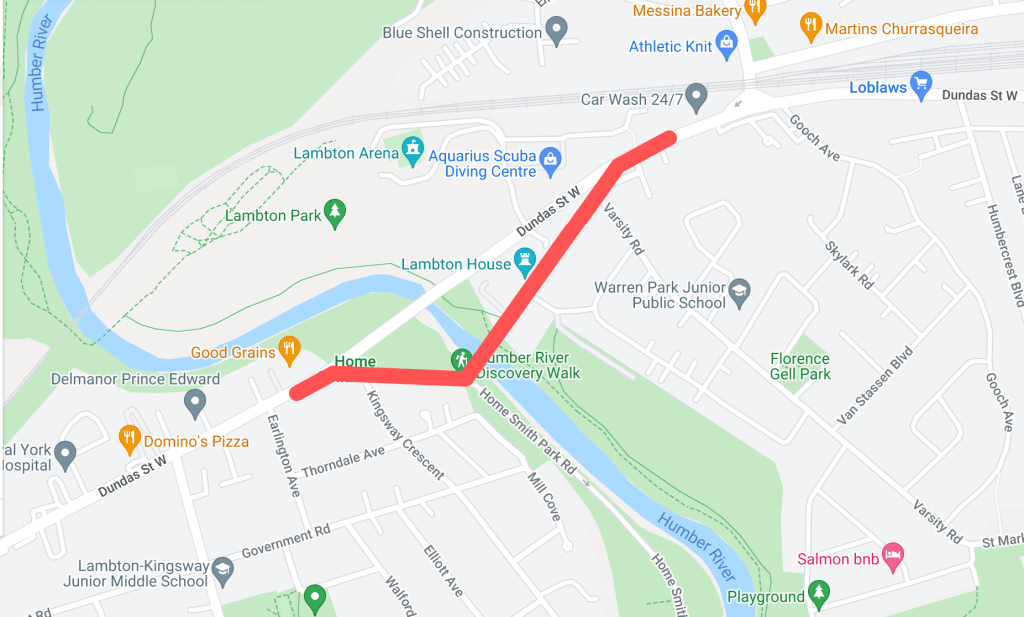
Historically, the main crossing over the Humber River on Dundas Street was located about two hundred metres south of the current bridge. This section of Dundas made up the old community of Lambton Mills and served as a main entrance into Toronto from the west on the Dundas highway. There were several versions of Dundas Street bridges here over the years — some made of wood, some iron, but all narrow for traffic and susceptible to the flooding waters of the Humber.
1924 Goads Fire Insurance Map of old course of Dundas Street. Source: Goad’s Toronto
In 1929, a new high-level bridge was completed over the Humber. This altered the main course of Dundas Street to the north. The old course became “Old Dundas Street”. For nearly thirty years, the two Dundas Street bridges existed alongside each other. In 1954, the devastating effects of Hurricane Hazel left the Old Dundas Street bridge in a dilapidated state; it was finally demolished several years later. Today, Old Dundas Street exists on both sides of the Humber River mostly as a quiet residential street. Lambton House, a historic inn turned museum, is a leftover of Old Dundas Street and Lambton Mills’ prominence.
“A New High-Level Bridge”, The Globe, January 16, 1929. Source: Globe and Mail Archives.1950 Aerial Image of Dundas Street and Old Dundas Street. Source: City of Toronto ArchivesOld Dundas Street, 2021. Source: Google Maps
Old Weston Road
Year rerouted: ~1948
Weston Road takes an interesting route through northwest Toronto, running diagonally through its street grid from the historic town of Weston (makes sense, eh?) and creating some unconventional intersections. North of St. Clair Avenue, the route of Weston Road was historically located east of the present road on the other side of the train tracks. It made up the historic village of Carlton with St. Clair and Weston as its nexus. It is highlighted by the still standing, yet altered Heydon House Hotel, built 1890. Weston then ran south to join with Dundas Street.
1851 JO Browne Map of Toronto showing Weston Road and the village of Carlton. Source: Old Toronto Map1927 Heydon House. Source: City of Toronto Archives
Around the 1890s, another “branch” of the street was built north from Keele Street running parallel to the railway on its west side. This street took on the name “Weston Road South”. In the 1910s, the street was completed to join with the main Weston Road.
1908 Map of Toronto showing Weston Road. Source: Old Toronto Maps1909 Map of Toronto showing Weston Road. Source: McMaster University1910 Old Weston Road bridge over C.P.R. Source: City of Toronto Archives
Perhaps because Weston Road South offered a more direct route south into the city, it formally became the more prominent road in the 1940s. First, an “Old Weston Road” began to refer to the section of Weston Road between the railway and Hillary Avenue. This meant that at one time a person could stand at the intersection of Weston Road, Old Weston Road, and Weston Road South. In 1948, Weston Road South became just Weston Road. Also, the entirety of the older eastern section of Weston Road was renamed Old Weston Road, save for the section between the tracks and Hillary which was added to Rogers Road. As the tracks to the south grew, the section of Old Weston near Dundas became severed from the rest of the road. Today, Old Weston Road is a mostly residential street.
1945 Map of Toronto showing Weston Road. Source: Old Toronto Maps1948 Toronto Transit Commission Map showing Weston Road. Source: University of Toronto Map & Data Library.1951 Map of Toronto showing Weston Road. Source: University of Toronto Map & Data Library.
Old Eglinton Avenue
Year rerouted: ~1957
For an east-west street that has become so vital to Toronto’s street grid and home to many neighbourhoods, it is difficult to imagine that Eglinton Avenue did not always exist in one harmonious stretch of road. However, it took some doing to make it into the street of today. Until the 1950s in the eastern half of Toronto, Eglinton Avenue terminated near Brentcliffe Road in Leaside and did not resume again until Victoria Park Avenue in Scarborough. The area in between them was about a five-kilometre stretch of farmland and two ravines — that is, both the east and west branches of the Don River. In the mid-1950s, a massive project was undertaken to join the two sections.
1950 Aerial Image of the future location of the Eglinton Avenue East extension. Source: City of Toronto Archives1953 Map of Metropolitan Toronto. Source: York University Archives 1954 Aerial Image of the future location of the Eglinton Avenue East extension. Source: University of Toronto Map and Data Library
While an “Old Eglinton Avenue” seems to come out of the events of the 1950s, it seems a little unclear why. The street runs parallel to the “new” road for about half a kilometre west from Bermondsey Road. Like the surrounding area, it mostly houses industrial buildings. As Eglinton did not seem to exist between Leaside and Scarborough (at least not in any formal sense), the story of Old Eglinton is a bit of a mystery. Hiking The GTA has located an old roadbed for an “Old Eglinton Road“. This may have been a farm road or a line that divided farm lots. It is also notable how Old Eglinton Avenue aligns with a “pencilled in” Eglinton Avenue between Victoria Park and Leaside, so a theory may lay in that idea.
Extension of Eglinton Avenue east across the West Don River, 1955. Source: City of Toronto ArchivesOld Eglinton Avenue, 2020. Source: Google Maps
Old York Mills Road
Year rerouted: ~1972
The valley near Hogg’s Hollow has proven to be an obstacle to road transportation several times in its history. As I previously noted, Yonge Street was realigned in 1835 after skirting east to better tackle the West Don ravine’s topography. Because of this same geography, Wilson Avenue terminated at Mason Boulevard, meaning there was no direct east-west crossing at Yonge Street as we know it today. In 1972, a project was undertaken to extend Wilson to meet with Yonge and York Mills Road.
1971 Aerial Image of York Mills Road and Wilson Avenue. Source: City of Toronto Archives“Extension of Wilson Avenue”, Toronto Star, May 28, 1972. Source: Toronto Star Archives
To make this extension happen, a curved road was constructed from Wilson Avenue which then crossed Yonge Street and joined York Mills Road between Campbell Crescent and York Ridge Road. This meant the straight section of York Mills near Yonge Street was effectively separated from the main route, becoming “Old York Mills Road”. Today, Old York Mills houses a trailhead, a passenger pickup zone for York Mills Station, a condominium, and a church.
Old York Mills Road and Wilson Avenue Extension, 1973. Source: City of Toronto Archives.
Old Kennedy Road
Year rerouted: ~1987
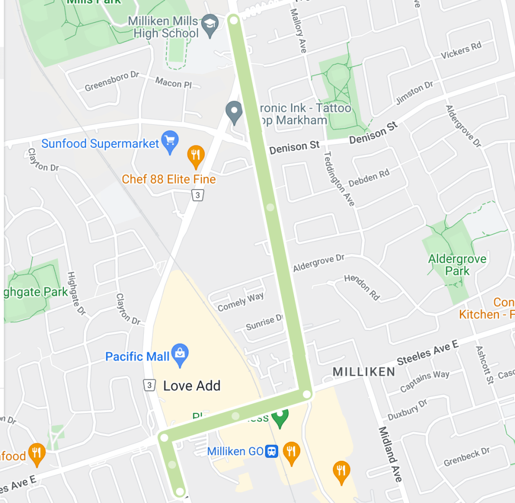
Kennedy Road just north of Toronto is a prime example of how of a noticeable curve in a street sometimes denotes a street was re-engineered. Kennedy existed in two separate sections north and south of Steeles Avenue, the Scarborough-Markham town line. The roads were about six hundred metres apart, meaning a northbound traveller from Scarborough had to jog east and then north again to continue into Markham. The area as a whole is and was known as Milliken, a historic community with the uncommon characteristic of existing within both municipalities.
1954 Aerial Image of Kennedy Road. Source: University of Toronto Map & Data Library
In 1987, the two sections of Kennedy Road were connected by a curving road running north from Steeles which veered east to meet the Markham section of Kennedy just north of the newly created Denison Street. The circumstances behind the re-alignment were unclear, but given Kennedy Road’s history as a ‘highway’ in Scarborough and the tendency in and around Toronto to harmonize streets within bordering jurisdictions, it is easily conceived why the jog was removed.
1987 Aerial Image of Kennedy Road. Source: City of Toronto Archives.
The eastern section of Kennedy became “orphaned” and was renamed Old Kennedy. Old Kennedy stops at Denison and continues on as Fresno Court, which in turn ends at a cul de sac. A fence separates it and Kennedy Road. Old Kennedy Road is an interesting mix of industrial and residential, with several older-looking houses near Steeles, perhaps lending back to the days when it was a hub in the village of Milliken.
Fresno Court, 2020. Source: Google Maps
Old Finch Avenue
Year rerouted: ~1993
Finch Avenue in Scarborough is relatively straight for much of its course from the North York town line to the Pickering town line — except in its most eastern part. Where Finch passed through Staines Road, the street at one time did a triangular job around the CPR tracks (the detour seems to have been created in the 20th century).
1916 Map of Townships, York, Scarboro, and Etobicoke. Source: University of Toronto Map & Data Library1954 Aerial Map Showing Finch Avenue. Source: Source: University of Toronto Map & Data Library
Further along, Finch did another jog up Sewell’s Road before meandering across the Rouge River and around its valley. It continued straight toward Kirkham’s Road (today’s Meadowvale Road). As there is today, there was an uncleared section of land across to Beare Road, thus one would have to jog up again to Plug Hat Road and back down to reach Finch again. The street resumed once more on its way to the Pickering Border. This stretch of Finch between Sewells and Kirkham’s made up the historic community of Hillside which had a church, school, and mill. The village made up much of the Rouge lands today from Sheppard Avenue/Twyn Rivers to Steeles Avenue.
1965 Aerial Image of Finch Avenue. Source: City of Toronto Archives.1969 City of Toronto Directory showing Finch Avenue. Source: Toronto Public Library
By the 1980s, changes came to Finch Avenue. Morningside Avenue curved from the south to meet Finch. Then, in or around 1993, the street was extended further north of Finch. This changed the alignment of the Finch/Staines intersection and effectively split Finch Avenue. Travellers moving east on Finch had to now follow the curving street north to Morningside Avenue and then curve back south via the same street. The east-west street on the other side was “Old Finch Avenue”, following the older, winding alignment. Because of this, the street bunks the trend of “old” streets which were leftover sections of the re-routed street; there is/was not ever a “newer” Finch Avenue that existed alongside the street. Old Finch terminates at Meadowvale Avenue; after Beare Road, it becomes Finch again and continues into Pickering for another eight kilometres.
“New Metropolitan Toronto Zoo Site”, Toronto Star, June 17, 1972. Source: Toronto Star Archives“Star Trek Run” Toronto Star, June 3, 1978. Source: Toronto Star Archives1983 Aerial Image of Finch Avenue. Source: City of Toronto Archives
Today, Old Finch is mostly known for its ‘haunted’ Bailey bridge and being the northern border of the Toronto Zoo, whose postal address is 361A Old Finch Avenue. The reconfiguration at Staines also facilitated the Morningside Heights neighbourhood.
“Grand Opening”, Globe and Mail, May 20, 1993. Source: City of Toronto Archives
2022 Finch Avenue. Source: Google Maps
The Older Finch Avenue
Year rerouted: 1977
Old Finch Avenue in the Rouge Valley was not the first Old Finch in the city. There was once a severed section of the street near Victoria Park in the old community of L’Amoreaux when the street was realigned directly across the Scarborough-North York border. This curved realignment eliminated a jog along the town line for east-west travellers. This Old Finch Avenue was closed in 1977; Pawnee Avenue roughly follows its old right of way.
1975 Aerial Image of Victoria Park and Finch Avenue Source: City of Toronto Archives
“Borough of North York Notice of Road Closing”, The Globe and Mail, September 9, 1977. Source: The Globe and Mail Archives
For a Google map of “Old” Toronto Streets, click here.
Map of “Old” Toronto Streets. Source: Google Maps Created by: Bob Georgiou
If you have any information to add or have any stories from any of these locations, leave a comment below or email bob@scenesto.com!
Toronto’s street grid is over 200 years old by colonial standards and even older with its Aboriginal trails. There have been additions and extensions, widenings and improvements. They have also been named to reflect the city’s past and present and it values (by those who do the naming, that is) – and to help the postal service.
The city is not a static object and neither are street names. Revisions and renamings have been an understated part of Toronto’s history. However, not all street renamings — proposed and actual — have gone over well. What is the mainly reason for this opposition? Simply put: History and Tradition. Whether successful or not, these episodes in Toronto’s history inform us how the city operated and why Toronto’s geography is as it is today.
Here are seven examples of controversial street name changes:
Old and New St. Patrick Street
In 1917, modern Dundas Street was created by amalgamating and connecting several smaller streets. One of these roads was St. Patrick Street, which ran between McCaul Street and Bathurst Street.
St. Patrick Street looking west to Spadina Avenue, circa 1911. Source: City of Toronto Archives 1913 Goad’s Fire Insurance Map. Source: Goad’s Toronto
One group opposed to changing St. Patrick to Dundas was the St. Patrick’s Old Boys’ Association, which attended the old St. Patrick’s School on William Street. The group deputed to City Council, but was unsuccessful. The story was not all bad as William Street was later renamed to St. Patrick Street to keep the tradition.
Dundas Street, looking east towards McCaul Street (home of St. Patrick’s Church with the new St. Patrick’s Street behind it), 2021. Source: Google Maps
Mimico Mixups
In 1929, a dispute over the renaming of 54 Mimico streets spanned several council meetings. At issue, Toronto’s postal service requested the changes after Mimico and Long Branch were placed in the Toronto postal region. The difficulty was the added municipalities added duplicate street names to the region and potential confusion for postal workers. An ex-mayor attended a September 1929 council meeting arguing why the inclusion of ‘Mimico’ in the mailing addresses would not be sufficient enough for postal workers. Matters got heated in an October meeting when Mimico Mayor and Liberal candidate W.A. Edwards accused Minister of Health and Conservative candidate Dr. Godfrey of “insincerity” when Dr. Godfrey opposed the name changes when the mayor rejected Dr. Godfrey’s wish to have Stanley Avenue changed to Godfrey Crescent.
1924 Goad’s Fire Insurance Map Source: Goad’s Toronto
It is unclear whether the by-law change went through, but in the October council meeting, it was moved and seconded that a second reading for the proposed by-law change be conducted. The Mimico street grid remains generally intact since the 1920s, albeit with notable changes: Church Street is now Royal York Road, Salisbury Avenue is now Park Lawn Road, Brant Street is now Dalesford Avenue, and Winslow Avenue is now Douglas Avenue.
Mimico, 2021. Source: Google Maps
Long Branch Street Changes & Disappearances
In 1952, a ratepayers association in Etobicoke protested the changing of part of Lake Promenade Road to Island Road in Long Branch. Lake Promenade existed in two sections on either side of the main branch of Etobicoke Creek, running all the way to Applewood Creek. To eliminate confusion for postal workers, it was proposed for the western section of Lake Promenade be added to Island Rd, which it already connected to.
1953 Aerial Image Source: City of Toronto Archives
Residents of Island Road did not like the idea as a recent storm severely damaged and condemned several homes on Lake Promenade and the association with that event to their properties was unwanted. The change ultimately took place by 1955, although it ultimately did not matter as the fallout of Hurricane Hazel caused the expropriation of homes on Island and Lake Promenade near Lake Ontario and Etobicoke Creek, as well as the complete removal of Lake Promenade west of Forty Second Street, James Street west of Forty Second Street, all of Forty Third Street, and Island Road parellel to the lake. Today, much of the area is parkland.
2022 Aerial Image. Source: Google Maps
The Pioneers of Scarborough
In 1957, Scarborough Council was tasked with submitting a list of alternate names for 210 streets duplicated elsewhere in the City. Metropolitan Toronto was standardizing operations and services across the city in the decade, including eliminating duplicates of street names.
1957 Map of Metropolitan Toronto Source: University of Toronto Map & Data Library
Confusion over postal delivery was again at issue, but names on the list included Brumwell St, Cornell Avenue, Harris Avenue, Kennedy Road, Little’s Road, Lennox Avenue, Muir Drive, and Paterson Avenue — streets named for Scarborough pioneers. Most streets seem to exist today, save for Lennox Avenue and Agincourt’s Paterson Avenue, which became Reidmount Avenue.
Kennedy Road, looking south to Reidmount Avenue (which amalgamated with the former Paterson Avenue), 2021. Source: Google Map
The Many Orioles
In 1958, duplication was at issue again in midtown Toronto with a proposal to rename the similarly named Oriole Crescent, Oriole Gardens, and Oriole Road. The names were to become Holmfield Crescent, Lower Canada Gardens, and Campus College Road, respectively.
1957 Map of Metropolitan Toronto. Source: University of Toronto Map & Data Library
Fifteen “angry” women of the three streets united to protest the move, even going as far as saying they’d be willing to go to jail for taking down the new signs if they ever went up. They cited the beauty, history, and fame of the “Oriole” name and the inconvenience it’d cause for people living on those streets to having to change addresses on documents. Ultimately, the names remained as they were and as they are today.
Looking east down Oriole Gardens at Oriole Road, 2021. Source: Google Maps.
A Mega-Maxome Avenue
In 1962, Willowdale residents protested the renaming and merger of Halstead and Maxome Avenue to Harkness Street. The three streets were disjointed and together would “form a mile long thoroughfare north of Finch Avenue.”
1955 Map of Metropolitan Toronto. Source: University of Toronto Map & Date Library
A resident of Maxome, representing 37 others on the street, argued the historical naming of the street, which was honouring a surveyor who laid out the original blocks of the area. Ultimately, the proposal did not go through. Curiously, Halstead and Harkness have disappeared from the map, having the name Maxome Avenue instead. Today, Maxome has a windy course, like it was strung together from a few different streets, creating a mega-street of sorts.
Maxome Avenue, 2021. Source: Google Maps.
North York Pioneers
In 1979, Scrace Hill Drive in North York was renamed to Skymark Drive, prompting the opposition of the Scrace family. The Scarces had historical roots in the Finch Avenue and Leslie Street area formerly known as L’Amoreaux, donating land for a church and cemetery, still standing today as Zion Church.
1916 Map of The Townships, York, Scarborough, and Etobicoke. Source: University of Toronto Map & Data Library
The family wrote North York Council a letter, outlining the connection and how several Scraces were even on North York Council. The street was renamed to Skymark after the development on the street, as the old street had a confusing spelling and was not easy to find. North York Controller Esther Shiner said the new name was “such a pretty name” and she would find something else to name after the Scraces. Of irony, Esther Shiner would later become the subject of a street herself.
Skymark Drive, 2021. The Skymark Towers are behind the shot. Zion Methodist Church is on the left. Source: Google Maps.
Sources Cited
“Citizens Protest Against Change In Street Name.” The Globe, 9 Oct. 1952, p. 12.
“’Godfrey Crescent’ Causes Verbal Tilt At Mimico Council.” The Globe, 15 Oct. 1929, p. 16.
“Keep Traditions: Opposes Renaming Traditions.” The Globe, 6 Mar. 1957, p. 4.
“Petty Politics Involved In Changing Street Names.” The Toronto Daily Star, 15 Oct. 1929, p. 5.
“Sees Lakeshore Trustees ‘Trying to Hoodwink Us’.” The Toronto Daily Star, 9 Oct. 1952, p. 26.
“St. Patrick Old Boys Form Strong Body.” The Globe, 7 Apr. 1917, p. 21.
“Street Name Change Bruises Family Pride.” The Globe and Mail, 10 Dec. 1979, p. 4.
“Street Name Change Fought By Residents.” The Globe, 8 Feb. 1962, p. 4.
“Would Go To Jail: 15 Angry Women Save Their Street Names.” The Globe, 5 June 1958, p. 23.
Note: This article is written without any prior affiliation to or contextual knowledge of the history of the Highland Memory Gardens or the family farms of North York. Their inclusion is as a reference tool to show change.
This is Highland Memory Gardens. It is located near the intersection of Don Mills and Steeles Avenues, in Toronto’s north end. The development of this cemetery and its surrounding area is an interesting look into the creation and evolution of this inner suburbs.
This is the area around Highland Memory Gardens in 1860. Historically, the area consisted of lot 21 (at today’s Finch Avenue) to lot 25 (at Steeles Avenue) of the Third Concession East of Yonge Street (Leslie Street), which were generally 200-acre lots extending to the Fourth Concession East (Woodbine Avenue/Highway 404). Notably absent is a middle road (now Don Mills Road) between the two concession roads. The cemetery itself is located along the east side of the top half lot 23 and the bottom half of lot 24.
1860 Tremaine’s Map of York Country. Source: Old Toronto Maps
As seen this 1878 map, the area was part of the larger community of L’Amoreaux (also spelled L’Amaroux). The village crossed both sides of the North York-Scaborough townline, with its spine running along Finch Avenue and lots extending to Steeles and Sheppard Avenue.
The L’Amoreaux Post Office stood just west of Victoria Park Avenue on the south side of a lost section of Finch Avenue (it would be re-aligned through the townline in the 1970s). Further west, a Methodist Church and cemetery, a Temperance Hall, and School House stood near Leslie Street.
1878 Illustrated Atlas of York Country. Source: Old Toronto Maps
Looking west across Finch Avenue, 1955. The road jogs at Woodbine Avenue. In the distance, York School Section 12 (now Zion Schoolhouse) stands on the left of the street and Zion Primitive Methodist Church (now Zion Church Cultural Centre) stands on the right.
Below: York School Section 12 and Zion Primitive Methodist Church, 1957.
Source: Toronto Public Library.
Cutting diagonally through the large block was a creek, now named Duncan Creek. It ran from near Leslie and Steeles (where its namesake’s farming lots stood) to its terminus near Victoria Park and Finch. It does not to seem to have been a major source of industry, compared to the adjacent Don River which hosted a number of mills. In the 1916 map below, the creek slinks its away across lots, although its course is a bit off compared to the earlier maps and later aerial photographs.
1916 Map of Toronto, York, Scarboro, and Etobicoke. Source: University of Toronto Map & Data Library.
This 1954 aerial photograph is a visual of the area and tells us that even by this decade, the area still maintained its largely rural character. A more precise view of the creek is visible along with the greenery running along its course.
1954 Aerial Image. Source: University of Toronto Map & Data Library.
For the area plot that would become the Highland Memory Gardens, 1953 was last year it existed as farm fields. A key reference point is the small roadway leading from Woodbine Avenue to a farm near the banks of Duncan Creek. This roadway was the divisor between lots 23 and 24.
1953 Aerial Image. Source: City of Toronto Archives
The cemetery found a home to the west of Woodbine Avenue, with an entrance leading off the street. The initial layout of the cemetery is a circular path. Some “offshooting” paths seem to laid out as well.
1954 Aerial Image. Source: University of Toronto Map & Data Library
By 1956, an “arm” shoots off the southern half of the main circle, looping west to connect to the main roadway.
1956 Aerial Image. Source: City of Toronto Archives
By the close of the decade, the layout of the cemetery increased more with off shoots on the north of the main circle.
1959 Aerial Image Source: City of Toronto Archives
In 1962, more acreage is added westward and a pond on the north east corner of the plot seems to be more completed. The lawns of the ground look to be landscaped. A tiny building, potentially the administrative centre, appears at the top of the lot.
1962 Aerial Image Source: City of Toronto Archives
The midpoint of the decade saw few geographic changes, but the notable start of residential development to the west of the creek.
1965 Aerial Image Source: City of Toronto Archives
By 1968, the cemetery expands again to the west. It would be its last major territorial expansion. The subdivision to the west of the creek appears complete, clearly stopping at the property line midway between Woodbine and Leslie.
1968 Aerial Image Source: City of Toronto Archives
By the start of the 1970s, development starts to grow to the south of the cemetery, replacing the longtime farm buildings. An early Don Mills Road begins to curl in from the the south as well as an early McNiccol Avenue slinks from west to east.
1970 Aerial Image Source: City of Toronto Archives
By 1973, the farm buildings near the creek are razed as the land is about to be filled in by housing. The creek itself disappears under the subdivision to the south of the cemetery. The land north of the cemetery also sees new subdivisions.
1973 Aerial Image Source: City of Toronto Archives
By 1976, Don Mills Road is completed, seemingly bending through the area to provide a second access point to the cemetery. Townhouses are built between the creek and Don Mills Road.
1976 Aerial Image Source: City of Toronto Archives
By the 1980s, Highland Memory Gardens took on the form seen today. Highway 404 was completed in the late 1970s replacing the former Woodbine Avenue right of way. With that, the main entrance to the cemetery shifted to Don Mills Road with the old entrance off Woodbine being built over. Several other buildings would later fill the northeast corner.
1981 Aerial Image Source: City of Toronto Archives
Today, Highland Memory Gardens is part of the Hillcrest Village neighbourhood of Toronto, an area roughly encompassed by Steeles Avenue, Finch Avenue, Leslie Street, and Victoria Park Avenue.
The Zion Church and Schoolhouse still stand today as 19th century reminders, but references to the area as L’Amoreaux are non-existent today. The post office and its street are gone, with the Old Finch Avenue closed in 1977 and Pawnee Avenue roughly replacing it as the two Finches were connected. (The L’Amoreaux name does live on in Scarborough, of course.)
“Borough of North York Notice of Road Closing”, The Globe and Mail, September 9, 1977. Source: The Globe and Mail Archives
There is a trail and parkland which follows Duncan Creek; the Seneca Newnham Campus, founded in the late 1960s, now runs over a buried portion of the creek. The property lines of the 40-acre Highland Memory Gardens reference the old concession lots, offering a forgotten link to the past.
1975 Aerial Image of Victoria Park and Finch Avenue Source: City of Toronto Archives
Across the map of Toronto, there are several “Old” versions of major streets: Old Yonge Street, Old Leslie Street, et cetera. These are smaller and certainly older streets that predate yet still exist alongside their longer, newer counterparts.
How old are these “old” streets anyways? Why were they built as they were in the first place? Why were they replaced?
Tremaine’s Map showing old courses of Toronto’s streets. Source: Old Toronto Maps
Here are five examples of “Old” Toronto Streets and their histories:
1. Old Yonge Street
Year rerouted: 1835
When Yonge Street was laid out in the 1790s, it was not the continuous straight path we think of today. The sheer length of the street almost welcomed obstacles. At York Mills, the challenging topography around the West Don River caused it to divert east just south of York Mills Road. It curved north and back west to join the original course. In 1835, the street was realigned and straightened. It seems in the 1920s, Yonge Street was re-routed again slightly to the west to allow for better automobile navigation.
1851 JO Browne Map of the Township of York. Source: Old Toronto Maps
1950 Aerial showing Old Yonge Street and “new” Yonge Street. Source: City of Toronto Archives.
“Yonge Street, at York Mills, Again Takes Altered Course” The Globe, February 26, 1921. Source: Globe & Mail Archives.
Today, the old, “orphaned” course remains as part of Mill Street and Old Yonge Street. Old Yonge’s narrow, curvy course in parts maintains a rural quality. While at one time Yonge and Old Yonge once connected at its north end, this connection is now a roundabout. Finally, because of its length in the province, there are other Old Yonge Streets in Thornhill and Aurora.
Old Yonge Street, 2021 Source: Google Maps
Yonge Street, 2021. Source: Google Maps.
Source: Google Maps & Bob Georgiou
2. Old Sheppard Avenue
Year rerouted: ~1934
Sheppard Avenue once existed in two separate sections on either side of the Scarborough-North York border. A traveller wishing to travel east or west through the two streets had to jog about 300 metres on Victoria Park to reach the other section. In 1934, the two roads were joined through a curving road running from just past Woodbine Avenue to the lower street in Scarborough. The move was the idea of Ontario Premier George S. Henry whose estate stood where the new Sheppard Avenue connection ran.
1965 Aerial showing Old Sheppard Avenue and “new” Sheppard Avenue. Source: City of Toronto Archives
Today, the orphaned North York section of the old road now exists as residential Old Sheppard, albeit with small parts removed around Highway 404.
Lawrence Avenue is and was one of many streets which was impact by Toronto’s ravines. West of Victoria Park Avenue, Lawrence once took an interesting route across the East Don River Valley. Like Sheppard Avenue, there were two sections of the street: the Scarborough section which exists today and a North York section. The North York section jogged up Victoria Park over the Canadian Pacific Railway, ran briefly next to the track, and continued west for 1.5 kilometres. From here, it took a rather curvy route south down the East Don Valley, crossed the Don River via a bridge, and curved back north and west before continuing towards Don Mills Road. Presumably, this was easiest way in the 19th century to navigate the valley.
1860 Tremaine’s Map showing Old Lawrence Avenue Source: Old Toronto Maps
Looking southwest at intersection of Victoria Park Avenue and Old Lawrence Avenue exit, 1958. Source: Toronto Public Library
1959 Aerial showing Old Lawrence Avenue Source: City of Toronto Archives
Lawrence Avenue E., bridge over East Don River, looking northwest,1955. Source: Toronto Public Library
In 1961, Lawrence Avenue was straightened with a road directly connecting Victoria Park and Woodcliff Place, curling northwest from Scarborough with several new bridges to accommodate the Don River and CPR.
1960 Aerial showing Old Lawrence Avenue and “new” Lawrence Avenue under construction. Source: City of Toronto Archives.
Lawrence Avenue East and CPR bridge under construction, circa 1960. Source: City of Toronto Archives.
Today, the orphaned old road exists as roughly as part of Roanoke Road and, more famously, a short access road to the East Don Trail named Old Lawrence. The remaining section west of the river along with the old bridge itself have been lost.
Like Lawrence Avenue, Leslie Street’s course at one time also had to divert around the East Don River. Also of 19th-century origin, a traveller going north on Leslie had to turn west for a short distance and then northwest for about 500 metres to meet with Sheppard Avenue. There was then a jog east on Sheppard, which included a bridge over the river and finally a left turn to travel north again.
1860 Tremaine’s Map showing Old Leslie Street. Source: Old Toronto Maps
1953 Aerial showing course of Old Leslie Street. Source: City of Toronto Archives
Sheppard Ave. East bridge near Leslie Street, 1964. Source: City of Toronto Archives.
In the 1950s, with the construction of Highway 401, Leslie Street was altered to curve through the highway, but the course has otherwise remained the same. In 1968, the street was reconfigured again to join with Sheppard more directly. The Don River was also straightened and a new bridge was constructed which spanned the entirety of the new four-way intersection.
1967 Aerial of “new” Leslie Street under construction. Source: City of Toronto Archives.
Today, the old course remains as Old Leslie Street, albeit a shorter version of the original route is available today to the public. It joins the new Leslie Street via Esther Shiner Drive. South of that street, there are City facilities. North of Esther Shiner, Old Leslie serves the Leslie Street TTC Station before it crosses over Sheppard via an overpass. It then curls back down to join the street (there is also a parking lot with an entrance to the East Don Parkland trail).
The original course of Cummer Avenue west of Leslie Street was an 1819 construction. The street was laid out as a side road from Yonge Street by the Cummer family to access their holdings (a mill and camp) near the East Don River. When it approached the valley, it curved down to roughly follow the river’s course. It crossed the river via a bridge and eventually the railway tracks at a level crossing. Finally, it terminated at Leslie Street.
1860 Tremaine’s Map showing Old Cummer Avenue Source: Old Toronto Maps
1968 Aerial showing course of Old Cummer Avenue. Source: City of Toronto Archives
By 1969, the street was rerouted to curve north away from the river (which looks to have been straightened around this time as well). The street passed through a new wider bridge over the Don River and then under a railway overpass before eventually becoming McNiccol Avenue at Leslie Street.
1969 Aerial showing “new” Cummer Avenue under construction and Old Cummer Avenue. Source: City of Toronto Archives
The old, orphaned course still exists in parts. The curved section lives on as part of the East Don Parkland trail, although not all of it follows the old path. The old bridge is in situ as well. The trail travels east through the hydro corridor where it terminates at the railway tracks. On the other side, Old Cummer Go Station and a hundred-metre long Old Cummer Avenue hold the old name.
Note: The City of Toronto refers to the Don Mills Trail as running from York Mills Road to just north of Eglinton Avenue. Google Maps labels the path north of Bond Park as the Leaside Spur Trail. These two names are generally used interchangeably. As this article will focus on the northern part of the trail, Leaside Spur Trail will be primarily used.
The neatest feature on the Leaside Spur Trail is also the most visible sign of its history. This is an elevated bridge with a narrow tunnel connecting Bond Avenue and the linear parking lot of Bond Park.
The bridge was built in 1912 in preparation for a new railway spur. This line, built by the Canadian Northern Ontario Railway (CNOR), linked two existing railways to the north and south, with the failed idea of moving passengers to North Toronto Station. The spur line also travelled down to the Canadian Northern’s shops on Laird Drive in Leaside, explaining the Leaside name despite being nowhere near that community.
The Canadian Northern Ontario Railway before the Leaside Spur in the Map of the Townships, York, Scarboro, and Etobicoke, 1916. Source: University of Toronto Map and Data Library.
From the Bond Avenue bridge, the spur trail travels parallel to the adjacent Bond Park. The park has existed since at least the 1960s and its triangular footprint is shaped by the two railways. The street and park are named for the Bond family which farmed the area historically. On the other side of the trail are the industries of Scarsdale Road. There are unofficial entries points on both sides.
The Leaside Spur Trail then runs parallel to the existing railway. The path briefly travels under the York Mills overpass with exits points at Scarsdale and the Longos parking lot at York Mills Gardens. Cyclists can continue north through the Lesmill Business Park to the Betty Sutherland Trail and beyond.
The Leaside Spur Line finally opened in 1918, but the CNOR did not operate it. The CNOR folded in that year, and its assets fell to the Canadian National Railway (CNR or CN). The CNR used the right of way to move freight. It ceased operations altogether on the Leslie Spur Line in 1999 and the tracks were subsequently removed.
Leaside Spur Line in The Pleistocene of the Toronto Region, 1932. Source: University of Toronto Map & Data LibraryLeaside Spur Line in the Topographical map, Ontario, circa 1942. Source: City of Toronto Archives.
In the early 2000s, the City of Toronto purchased the former Leaside Spur right of way. In 2011, construction began on the Don Mills Trail. The section south of Bond Avenue was completed first. The future of the century-old Bond railway bridge was nearly in question. The section north of Bond Avenue, which before paved was previously a gravel path that dead-ended at a fence where the rail bed once met the CNR line, was finished in 2016 — fortunately with the restored rail bridge intact.
At the north end of the Leaside Spur Trail, there is a great piece of hidden history. For the majority of the 20th century, there was a railway station on the south side of York Mills Road where it met the CN line at a level crossing. Built in 1905, this was Duncan Station (later addressed at 845 York Mills Road). The station was named for the Duncan family. It served the farmers of Oriole and, later, the community of Don Mills. Duncan Station was later redubbed Oriole Station, possibly to avoid confusion with another Duncan Station on the line and to reference to the community to the north at today’s Leslie Street and Sheppard Avenue. For this reason, the Leaside Spur Line was also known as the Duncan Cut-Off and later the Oriole Cut-Off. Oriole Station was a two-storey structure and was notable in that it was a third-class Canadian Northern Railway station typically found in rural Western Canada.
The former Oriole Station in an undated photo, likely the 1960s or 1970s. Source: Toronto Public Library.
By at least the 1950s, Oriole Station was moved away from the tracks and replaced a smaller flag stop. The original station became a private residence. In 1954, the station briefly served as the northern terminus of the new Don Mills bus line during rush hour (permanent service was extended to the area a few years later). In 1970, the York Mills Road Overpass was completed over the railway, replacing the level crossing. Finally, CNR closed Oriole in 1978. In that year, GO transit opened a new transport hub further north on the corridor nearer to the historic location of Oriole at Leslie Street and Highway 401. It was called Oriole GO Station.
The second Oriole Station in 1955. Source: Toronto Public Library.Toronto Transit Commission System, 1954. Source: Transit Toronto.
In the 1980s, CN intended to demolish the surplus station over safety concerns. By this time, the abandoned station (vacated in 1984) was in a poor state and vandalized several times. In 1985, the North York Historical Board recommended the station to be moved to Moatfield Park at Lesmill Road and Leslie Street, restored, and then repurposed to a soccer clubhouse. Unfortunately, North York Council did not like the $100,000 price tag. The interest in saving the building lay in the former station being the oldest remaining railway station in North York and the last remaining third-class CNOR station in Ontario.
Reprieves and deferrals were granted in 1986, delaying the demolition while a solution could be found. CN was reported to be willing to lease the land to North York (to leave open the possibility of employing the land for future industrial uses) and keep the old Oriole Station in its historic location (albeit moved 20 feet away). At the same time, a North York teachers’ group expressed interest in buying the building and using it in situ as a clubhouse. The agreement was CN was to rent the property to North York for $9,600 a year, who would then sublet to the newly formed North York Railway House Faculty Club for the same price. The only caveat was the faculty club needed to raise a $100,000 letter of credit to cover rental payments if the club went bankrupt. In March 1987, with the teacher’s group unable to secure the financial requirements, North York advised the railway to proceed with demolition. The old Oriole Station was razed shortly after.
No markers or plaques currently stand to honour the Bond Avenue bridge, the Oriole Cut-off/Leaside Spur Line, or the former Oriole Station. They would likely have a decent audience as many walkers, cyclists, and joggers frequent the Leaside Spur Trail today.
The approximate former location of Oriole Station in 2021.
When does a place stop being a place? On the border of North York and Scarborough, there are two Sheppard Avenues. Old Sheppard Avenue runs east to west from Victoria Park Avenue to just shy of Highway 404. Sheppard Avenue East curves just south of the old street across the border of the two former municipalities.
These two streets — and triangular plot in between — hold quite the history and evolution of two lost junctions: O’Sullivan’s Corners and Muirhead’s Corners. Here is a brief account of their story.
Source: Google Maps.
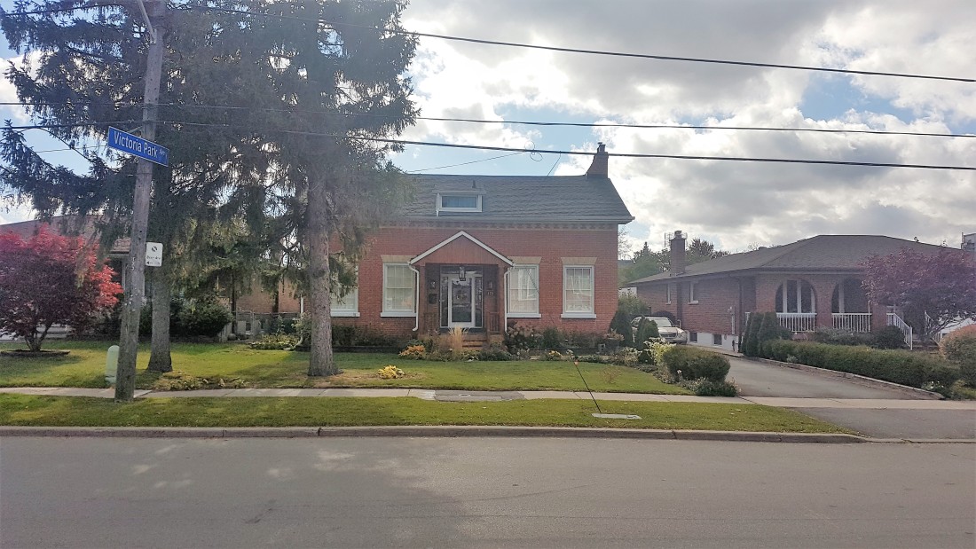
On Old Sheppard Avenue, there is a house unlike the others around it. Now situated in the middle of a modern subdivision, it was the farmhouse of the Alex Muirhead and his family.
The Muirheads settled the 100-acre plot of land known as Concession IV Lot 15 in York Township in 1853. Alex Muirhead would build his farmhouse in the Ontario Vernacular style in that same year, situating it on the south side of what is now Old Sheppard Avenue. The Muirhead name was prominent in the area — so much so that the odd junction on the northwest corner of the lot was known as Muirhead’s Corners in the early 20th century.
Concession IV Lot 15 from 1860 Tremaine’s Map of the County of York, Canada West. Source: Historical Maps of Toronto.
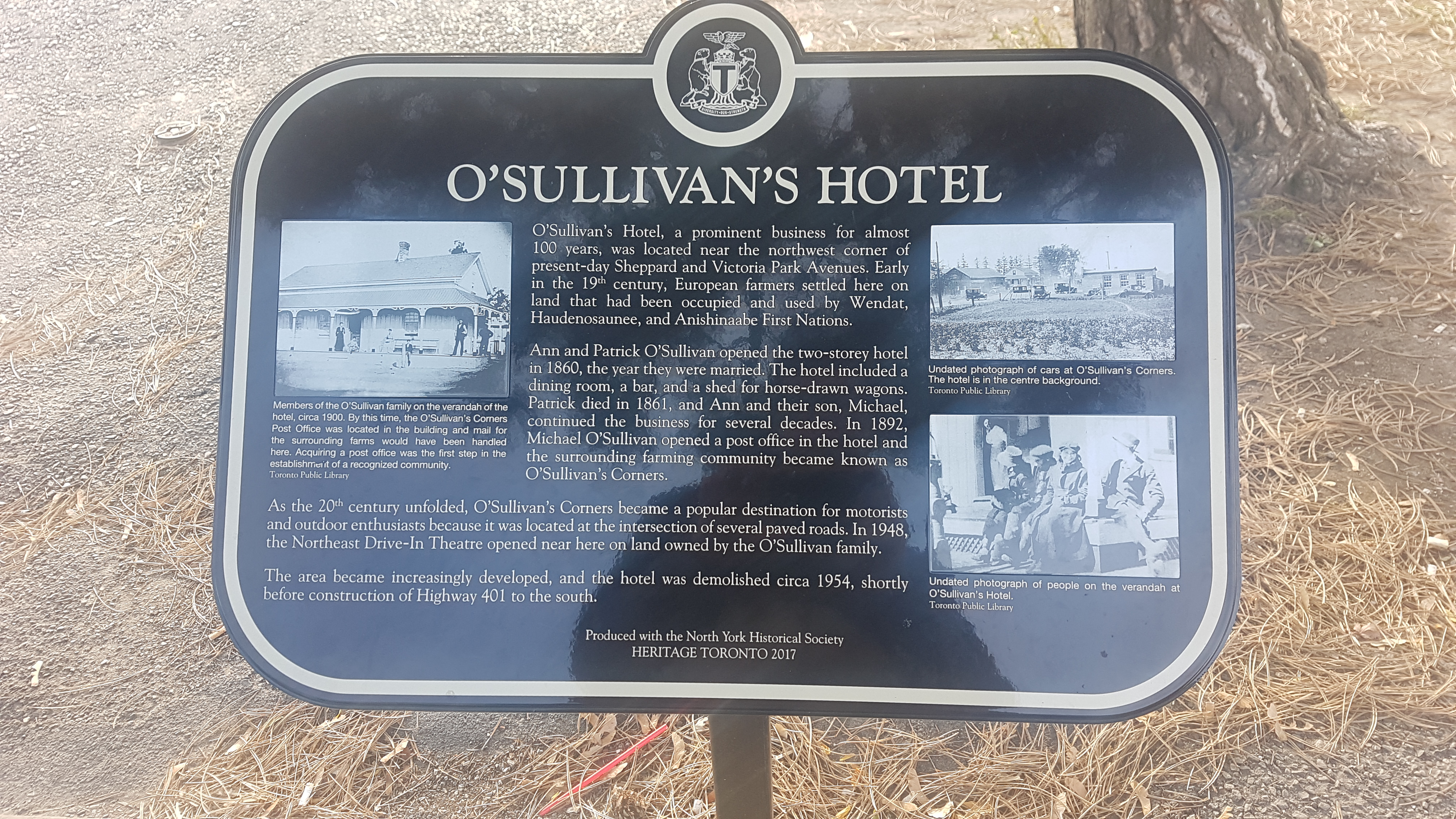
In 1860, Patrick O’Sullivan and Ann O’Reilly opened the O’Sullivan Hotel on the eastern part of Lot 14, directly south of the Muirhead property. The hotel featured ‘two bedrooms, dining room, and a bar’. The structure was situated on the west side of the York-Scarborough line across the Third concession on the Reilly farm.
O’Sullivan’s Hotel (centre background), circa 1920s. Source: Toronto Public Library & North York Historical Society.
1878 Illustrated Historical Atlas of the County of York. Source: Historical Maps of Toronto.
The area grew from here. In 1873, part of the O’Reilly land was used to house a one-room public school. The school — named School Section #23, later Victoria Park School –roughly served the west side of townline from today’s Lawrence Avenue to Finch Avenue. In 1893, a Post Office opened at the O’Sullivan Hotel, cementing the area as a community with the moniker O’Sullivan’s Corners. The area, sometimes shortened to just O’Sullivan, rose to local landmark status in the early 20th century.
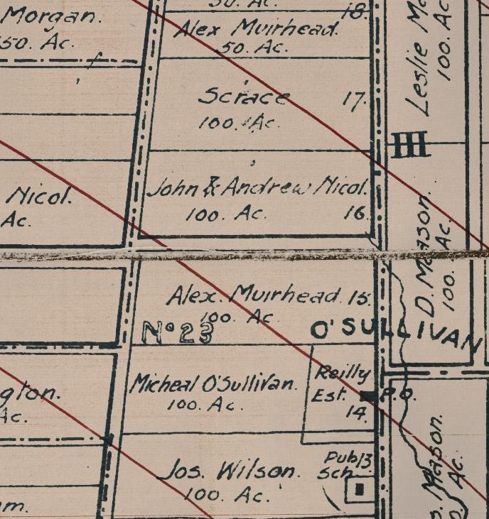
O’Sullivan and SS #3 from the Map of the Townships, York, Scarboro, and Etobicoke, 1916. Source: University of Toronto Map and Data Library.
School Section 23 (1873-1964), Toronto, Ont., 1956. Source: Toronto Public Library.
The rise of automobiles and highways in the early 20th century aided in the growth of O’Sullivan. Beginning in the 1910s, significant changes took place along the roadways of northern Scarborough and North York. Motorized vehicles were on the increase and, with them, convenient and leisurely long-distance travel through the suburbs of Toronto. One can imagine couples and families venturing through O’Sullivan’s Corners and stopping for a Sunday lunch.
Toronto Daily Star, September 11, 1925. Don Mills Road jogged east at York Mills Road and then north to what later be Woodbine Avenue. Source: Toronto Public Library.
The main east-west street through these parts was Lansing Sideroad (sometimes named Lansing Cut-Off), which — next to Kingston Road — was the main way from the centre of Toronto to Pickering and Oshawa. Named after the community it originated in, Lansing Sideroad extended east from Yonge Street, passing the community of Oriole at Leslie Street and Muirhead’s Corners at Don Mills Road (later Woodbine Avenue).It stitched together east-west routes connecting the Concession roads of North York: Bayview (2), Leslie (3), and Woodbine (4).
In the 1920s, newspapers presented weekend road trips through the areas around Toronto. Toronto Daily Star, September 9, 1927. Source: Toronto Public Library.
Lansing then jogged south at the townline near O’Sullivan before continuing into the Scarborough through Agincourt and Malvern following the old Third Concession Road. In 1911, Lansing Sideroad was paved to allow better navigation. It is unclear when it was named Lansing Road, but there is an early mention of improvements to the road in 1903.
The Globe, June 2, 1903. Source: Toronto Public Library
As the 1920s rolled into the 1930s, more upgrades were made to Lansing Sideroad. The Department of Public Highways of Ontario, created in 1916, sought to include the road in a larger highway network to improve motor vehicle travel. And so, on August 25, 1931, Premier George S. Henry inaugurated a new motorway between Lansing and Malvern on the street.
Toronto Daily Star June 21, 1929. Source: Toronto Public Library.
Toronto Daily Star, August 25, 1931. Source: Toronto Public Library.
In another huge development, the two sections of the Lansing Sideroad in Scarborough and North York were aligned in 1934. The new curved section of roadway donated and purchased from several landowners in the area and eliminated multiple jogs between O’Sullivan’s Corners at Dawes Road and Muirhead’s Corners at Don Mills Road. Travellers now could travel more seamlessly between townships.
Toronto Daily Star, June 15, 1934. Source: Toronto Public Library.
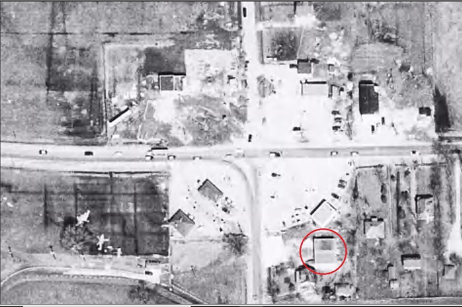
Aerial photo of Muihead’s Corners, O’Sullivan, and the Lansing Sideroad, 1954. Source: University of Toronto Map and Data Library.
Along with the O’Sullivan Hotel, there were service centres, gas stations, and some shops to serve the local and commuting populations of O’Sullivan and Muirhead’s Corners in the early 20th century. The North-East Drive-In Theatre also opened between the communities on Lansing Road in 1947, further building on the virtues of car travel.
Looking south on Victoria Park Avenue from north of Sheppard Avenue East, Toronto, Ont, 1958. Source: Toronto Public Library.
Woodbine Avenue looking west at Sheppard Avenue, 1965. Source: City of Toronto Archives.
Toronto Daily Star, September 23, 1947. The North-East Drive-In showed its final film in 1976 as the Consumers Business Park overtook the area. Source: Toronto Public Library.
The second half of the 20th century proved to be a transitional period for the area and the beginning of the end many things recognizable at O’Sullivan’s Corners. For a start, the road network was significantly altered — even more than before. Perhaps as a result of the new Metropolitan Toronto’s efforts to harmonize transportation in the city, Dawes Road and Lansing Sideroad both were renamed to Victoria Park Avenue and Sheppard Avenue East in the 1950s.
Victoria Park Avenue, Sheppard Avenue East, Lansing Road from 1955 Metropolitan Toronto Map. Lansing Side Road seems to have renamed in Scarborough even as the North York section became Sheppard Avenue. Both would be under the Sheppard name in the 1960s. Source: University of Toronto Map and Data Library.
The four-laned Toronto By-Pass — now Highway 401 — opened as the new east-west alternative to Kingston Road and Lansing Road in and out of the Toronto area in 1957. It included an exit at Victoria Park Avenue.
Toronto Bypass, 1956. Source: City of Toronto Archives.
And in a final update to motorways, Highway 404 replaced Woodbine Avenue north of Highway 401 by 1967. The move spelt the end of Muirhead’s Corners, as the junction was physically eliminated to make way for the highway. It also meant Old Sheppard was now cut off at its west end, now looping into a new Muirhead Road (near a school also named for the pioneer of the street).
Aerial of the Don Valley Parkway and Highway 404 under construction in 1966. Consumers Business Park is also roughed in. Source: City of Toronto Archives.
It is hard to pinpoint when O’Sullivan’s Corners stopped being O’Sullivan’s Corners, but the 1950s and ’60s is certainly a start. After nearly a century in operation, O’Sullivan’s Hotel was closed in 1954. The reasons? Perhaps interest had faded from patrons and management. Or the costs were too high. Its replacement was a gas station — a use the corner continues today. To its south, SS #23 was also lost in 1964 to accommodate more lanes for Highway 401. (Its belfry and bell was salvaged by Herbert and Rosa Clark and is now on display at the Guild Park in Scarborough along with our salvaged building fragments of the post-war era)
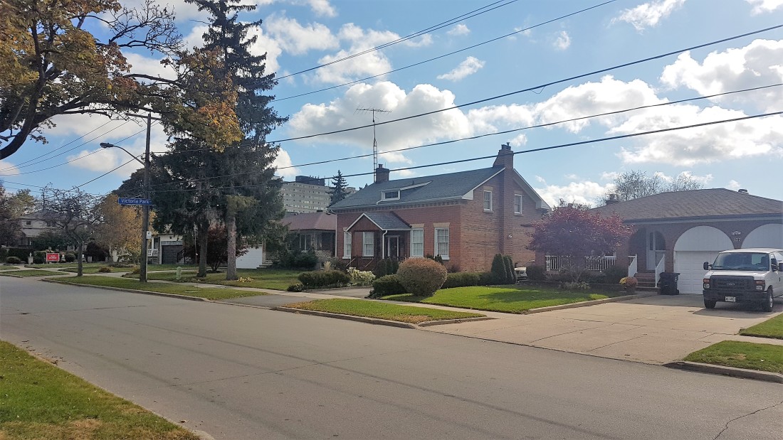
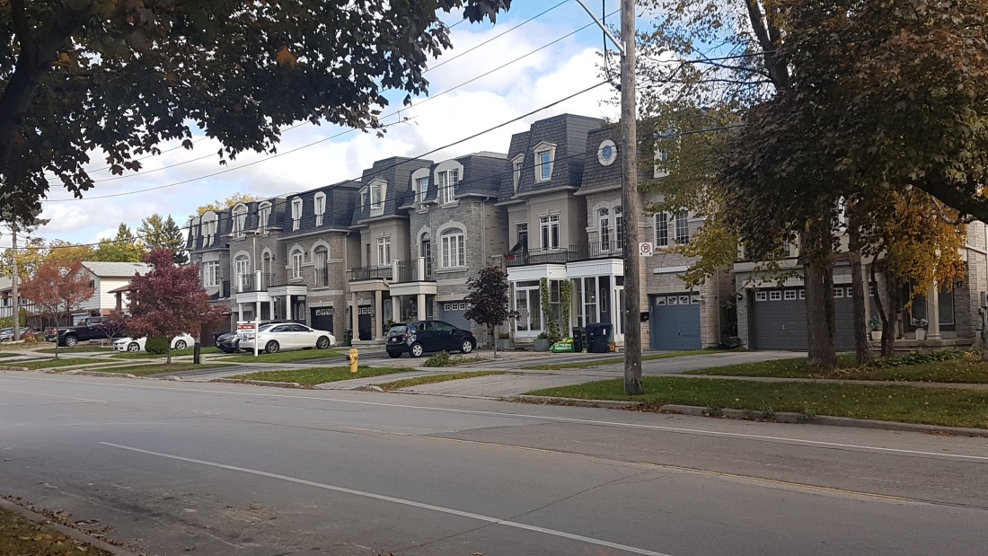
By at least 1950, the Muirhead farm was also divided up to host a new residential community. Brian Drive (originally Sandra Boulevard) and Patrick Boulevard both hosted houses with large lots. The old Muirhead farmhouse also received new neighbours on its street. Curiously though, Old Sheppard is unnamed in maps from the 1950s. (Perhaps the moniker came into existence when it was orphaned by the highway 404.)
Aerial of Old Sheppard, Brian Drive, Patrick Boulevard in 1953. Source: City of Toronto Archives.
In the early 1970s, brand new houses went in north of Patrick Boulevard and east of Brian Drive, replacing most of the housing stock from twenty years prior. The Muirhead farmhouse was already situated close to the street, so when the new houses went in beside it, it was relatively integrated into its surroundings.
Around the corner on Brian Drive, a line of more modern residences in the middle of the street curiously deviates from neighbouring housing styles. The story: When this area bought up and sold by redevelopers in the 1970s, it seems one property held out on selling. Its deep lot stretched to Wilkinson Drive, leaving the new streets in between incomplete. The holdout looks like it lasted about 30 years until around 2001 when four rows of infill development went in. With that, Doubletree and Wilkinson were finally connected.
Source: OldTO, 1992 vs 2020.
Source: Google Maps
Source: Toronto Star, April 14, 2001
On Patrick Boulevard, a house from the same era as the Brian Drive holdout residence remains. It never had to sell, though. This house is noticeable because, although it is neighbours with houses it predates, it is set back considerably from the street with a long driveway.
Source: Google Maps
On the west side of Brian Drive, apartment towers and townhouses went up steadily through the 1970s too. The ‘Crossroads’ buildings, in particular, are appropriately and geographically named.
Source: Globe and Mail, May 25, 1979
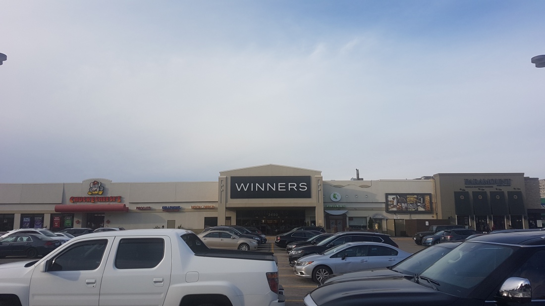
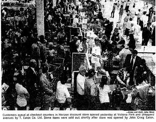
Victoria Park Square is the local mall for the area. It opened in 1972 on the former site of the O’Sullivan Hotel to serve the up-and-coming residences. It was known in those early days for hosting the first Horizon — Eaton’s chain of discount stores. A Heritage Toronto and North York Historical Society plaque today tells the story of O’Sullivan’s Hotel.
Source: Globe and Mail, August 17, 1972
In 1988, a second plaza was built at the corner of Brian Drive and Sheppard Avenue. Named ‘The Shoppes of Brian Village’, the plaza resembles a village centre. It was significant enough to warrant an Urban Design award from the city in 1988. The site also gives the area another name: Brian Village (or perhaps vice versa).
Source: Toronto Star, November 29, 1988
Today, this community is part of the modern Pleasantview census tract – a total area which reaches up to Finch Avenue East. It is a mix of mostly English and Mandarin speakers, with some Italian and Greek households.
The name is not in use anymore, but how much of O’Sullivan’s Corners is left? O’Sullivan School certainly lives at the Guild as a physical remnant. More than that, the busy nexus of Victoria Park and Sheppard — where the hotel once stood — may have a clue. Today, the intersection hosts a gas station, a breakfast spot, a pizza place, and a drugstore. Next to that drug store is the famed Johnny’s Hamburgers. The building housing Johnny’s is from about 1956. The burger joint got its start about ten years later by a Greek immigrant.
Victoria Park Avenue and Sheppard Avenue, shortly after the loss of O’Sullivan’s Hotel, 1956. Note the dual units. By 1970, it was just one unit: Johnny’s. Source: City of Toronto Archives.
Although it post-dates the era of the O’Sullivan Hotel, Johnny’s Hamburgers grew out of the car-centric circumstances that brought the area prominence. The simple, table-less interior also plays tribute to North-East Theatre as its one-time neighbour. Even if the place no longer exists, a visit to Johnny’s may a taste of the O’Sullivan community of old.
Throughout its history, the City of Toronto has reimagined its street grid. Growth periods following both World Wars brought with them road improvement schemes to address traffic congestion and better connect the city. Some projects – like the 1931 Church Street extension north of Bloor Street to Davenport Road – came to fruition. Others – most famously, the Spadina Road Extension-turned-expressway cancelled in 1971 – never saw their intended results. Here are four other road extensions in the 20th century that would have altered the geography of Toronto if built.
Victoria Street
When: 1900s to 1930s
In 1906, the Board of Works discussed the possibility of extending Victoria Street from Gerrard Street to Carlton Street for a new streetcar route. Yonge Street relief had been a theme in road improvement, with Bay Street extended north from Queen Street to Davenport in the 1920s (it was even proposed to extend it to St. Clair Avenue in the 1930s and 1940s). Estimates in 1911 had the Victoria-to-Carlton scheme costing as much as $500,000, and a report by the Civic Improvement Committee proposed to extend it further to Bloor. With costs to expropriate property proving too high, Civic Works abandoned the idea in 1912. City Planners revived the idea in a grander plan for downtown streets in 1929. In yet another city-wide improvement plan in 1930, Works Commissioner RC Harris recommended a streetcar-free Victoria Street that would stretch north via Park Road to join with the also-proposed Jarvis and Sherbourne extensions of Mount Pleasant Road. A council motion in 1935 envisioned Victoria ending at Davenport Road, but none of these plans came to fruition. Today, Victoria Street is in fact shorter, ending at Gould after its last block was absorbed by the Ryerson Campus.
Credit: Civic Improvement Committee Report, 1911.
St. Clair Avenue
When: 1920s, 1960s-1970s
A Council decision in 1928 by East York and York County first imagined uniting the two sections of St. Clair Avenue. Initial talks involved land offers and easements from John H. Taylor and the Toronto City Estates to complete the extension in the Don Valley. Discussions followed in 1929 on the course’s starting point and overall engineering. One route extended straight east from Mount Pleasant Road while the other travelled by way of Moore Avenue via a bridge spanning the Belt Line Ravine from St. Clair. From here, the street would connect to the new Leaside Viaduct, then follow Don Mills Road to Woodbine Avenue before finally bridging diagonally across Massey Creek. Moore Park residents disapproved of the Moore Avenue alignment as it meant more vehicular traffic. Discussion seemed to taper off in the 1930s. Reprises in the 1960s saw a valley-spanning St. Clair brought up again, but these too ended in 1970 when the Metro government decided not to proceed after facing public opposition and high costs.
Credit: The Globe, 21 January 1929
Cosburn Avenue
When: 1950s
As a candidate for East York Reeve in the 1956 election, Jack Allen campaigned on the eastward extension of Cosburn Avenue. After winning the position, he continued his push in 1957 and 1958, highlighting a scheme in which the street would continue past Woodbine Avenue by curving parallel to the disused CNR line in the Taylor-Massey Creek valley to connect with Victoria Park Avenue. The purpose was to relieve congestion at Woodbine and O’Connor. Allen also thought the extension would aid the case for a new courthouse at Cosburn and Woodbine and his vision of high-density apartment towers in East York. Parkland advocates at the Don Valley Conservation Association opposed the plan. Allen introduced a master zoning plan by developer and architect Sulio Venchiarutti of Urban Planning Consultants, but this was rejected by East York Council in 1959. A year later, the township adopted a different official plan and Allen was replaced as reeve by future mayor True Davidson.
Credit: Toronto Daily Star 08 Mar 1957
Leslie Street
When: 1960s to 1990s
Following initial suggestions in 1968 and failed proposals in 1971 and 1973, in 1976 Metro Planners brought forward a $20-million extension of Leslie Street south of Eglinton Avenue. Debates around the idea coincided with another valley-spanning proposal in the 1970s for the direct routing of Lawrence Avenue from Bayview to Leslie. Arguments in favour of a lengthened Leslie centred on eased congestion – at the Leslie/Eglinton bottleneck and at neighbouring north-south avenues – while arguments against cited ravine destruction. Another report in 1983 and an environmental study in 1984 seemingly had the now $50-million scheme moving forward, with the route involving a high-level bridge over Wilket Creek Park, followed by a road along the CPR Belleville line before emerging at the Bayview Extension near Nesbitt Drive. Citizen groups argued that, if allowed, the Leslie proposal would re-open the Spadina Expressway debate. In 1988, Metro Council voted in favour of the 4-lane extension, but the price had gone up to $74 million dollars. Debate and public consultations continued into the 1990s with no extension built. In 2000 and 2002, Toronto Councillor Jane Pitfield proposed lengthening Redway Road to Bayview. Opponents feared the damage to Crowthers Woods and a rehashing of the Leslie debate, and nothing came of that plan either.
Credit: Toronto Star, 20 November 1984
Sources
Victoria Street
“Planned New Car Lines” The Globe. 19 May 1906: pg 9.
“Open Victoria Street.” The Globe. 15 March 1907: pg 9
“The Extension of Victoria Street.” The Globe. 2 November 1909: pg 6.
“Victoria Street Extension.” The Globe. 14 January 1910: pg 7. – 330,000
“Extend Victoria St Under New Stature.” The Globe. 22 April 1911: pg 9. – 360,000
“Victoria Street Extension Favored.” The Globe. 3 June 1911: pg 8.
“C.P.R. to Keep Building Site.” The Globe. 28 July 1911: pg 8. – half-million
“Many Important Schemes for the Betterment and Growth of Toronto.” Toronto Daily Star. 30 December 1911: pg 5.
Report of the Civic Improvement Committee for the City of Toronto, 1911
“City May Abandon Victoria Extension.” The Globe. 24 February 1912: pg 9.
“Will Try Arbitration.” The Globe. 2 March 1912: pg 4.
“Victoria Street Extension Killed.” The Globe 18 May 1912: pg 9.
“Make Bloor Street Big Business Centre.” The Globe. 20 March 1917: pg 7.
“City Planners Propose New Downtown Streets.” The Globe. 12 March 1929: pg 15
“Work Commissioner R.C. Harris Presents New City-Wide Project.” The Globe. 15 May 1930: pg 13.
“A Bay Street Plan.” The Globe. 17 January 1930: pg 4.
“Victoria Extension Favored by Expert.” The Globe. 21 November 1930: pg 13.
“Report is Requested on Victoria Extension” The Globe. 26 September 1931: pg 14.
“Victoria Street Extension to Davenport Road Talked.” The Globe. 12 February 1935: pg 11.
St. Clair Avenue
“St. Clair Extension.” The Globe. 21 December 1928: pg 2.
“Favor Taylor Proposal St. Clair Ave. Extension.” The Toronto Daily Star. 21 January 1929: pg 3.
“St. Clair Extension Through East York Offer of J.H. Taylor.” The Globe. 21 January 1929: pg 13.
“Problem of Bridges Northeast of City has Many Angles.” The Globe. 5 February 1929: pg 23.
“Hottest Discussion at County Council on Radial Proposal.” The Globe. 7 June 1929: pg 28.
“Easement Offered for Further Link Extending St. Clair.” The Globe. 23 June 1929: pg 13.
“Citizens Reassured on Extension Plans.” The Globe. 22 August 1929: pg 21.
“Action Expected on Moore Avenue Boundary Bridge.” The Globe. 30 July 1929: pg 13.
“Objects to Bridge.” The Globe. 22 August 1929: pg 4.
“The Moore Park Bridge.” The Globe. 7 September 1929: pg 4.
“Residents Agitated By Bridge Question in Northeast Area.” The Globe. 20 September 1929: pg 17.
“M’Bride Declares St. Clair Extension ‘Out of Question’”. The Globe. 21 September 1929: pg 18.
“Scarboro Plans Work on St. Clair to Aid Jobless.” The Globe. 17 December 1930: pg 10.
“Request St. Clair Cross Don Valley.” The Globe and Mail. 31 October 1962: pg 5.
“Urban Renewal Study for Metropolitan Planning Area Covering 750 Square Miles Is Proposed.” The Globe and Mail. 7 February 1963: pg 4.
“Metro Shelves St. Clair Plan.” The Globe and Mail. 9 September 1970: pg 5.
Cosburn Avenue
“Promise to Campaign for Industry in Suburbs to Balance Housing Surge.” The Globe and Mail. 30 November 1956: pg 11.
“Site on Cosburn Ave. Urged for Courthouse.” The Globe and Mail. 14 February 1957: pg 4.
“Urge Alternate Site for E. York Court.” The Toronto Daily Star. 14 February 1957: pg 19.
“Reeve Asks Old Railway Be Expressway.” The Toronto Daily Star. 8 March 1957: pg 9.
“Reeve of East York Backs New Buildings.” The Globe and Mail. 3 December 1957: pg 5.
“Conservation at the Polls.” The Globe and Mail. 8 November 1958: pg 6.
“Residents Oppose Cosburn Extension.” The Toronto Daily Star. 6 June 1958: pg 29.
“Metropolitan Toronto: Scratch-My-Backism And the Courthouse.” The Globe and Mail. 26 June 1958: pg 7.
“Expect Hot Contests in Suburbs.” The Globe and Mail. 18 November 1958: pg 5.
“Cosburn Plan Foes Cut Chairman Short.” The Toronto Daily Star. 25 November 1958: pg 9.
“The Suburban Elections.” The Toronto Daily Star. 28 November 1958: pg 29.
“East York Greenbelt Should be Saved.” The Toronto Daily Star. 20 December 1958: pg 29.
“East York Zoning.” The Toronto Daily Star. 11 April 1959: pg 29.
“Suites to Oust Homeowners?” The Toronto Daily Star. 16 April 1959: pg 1.
“Raze Homes for Apartments?” The Toronto Daily Star. 16 April 1959: pg 3.
“It’s Improper, Mr. Venchiarutti.” The Toronto Daily Star. 20 April 1959: pg 29.
“Appraiser’s Kin Swung Land Deal, Probe Told.” The Toronto Daily Star. 21 May 1959: pg 2.
“East York Plan Limits Apartments to 5 ‘Pockets’”. The Toronto Daily Star. 22 June 1960: pg 41
“An East York Dialogue on Conflict of Interest.” The Toronto Daily Star. 19 June 1961: pg 7.
Redway, Alan. East York 1924-1997: Toronto’s Garden of Eden. FriesenPress, 2018.
Leslie Street
“Subway Expansion, Restriction on Cars, Sought for Toronto.” The Globe and Mail. 26 March 1968: pg 1.
“Time Needed for Study: Planners delay Flemingdon Scheme.” The Globe and Mail. 21 November 1968: pg 5.
“Transit Can’t Cope: Planners Want to Widen Metro Roads.” The Globe and Mail. 10 July 1976: pg 5.
“Here’s a plan to improve traffic.” The Toronto Star. 29 January 1979: pg A8.
“Alderman Says Extension Won’t Solve Traffic Mess.” The Toronto Star. 31 August 1979: pg A15
“Transport Plan Not Changing: Eggleton.” The Globe and Mail. 11 May 1984: M3.
“Battle Won by War Still Undecided on Extending Leslie past Eglinton.” The Toronto Star. 20 November 1984: pg A25.
“Neighbors Protest Bayview-Leslie Road Plan.” The Globe and Mail. 31 March 1988: pg A16.
“Leslie Extension Sparks Emotional Debate.” The Toronto Star. 13 April 1988: pg A7.
“Leslie Street Debate Resurfaces.” The Globe and Mail. 23 March 1991: pg A9.
“Notice of Public Hearing: Leslie Street Extension on Bayview Avenue Widening.” The Toronto Star. 27 August 1992: pg A26.
“Plan for Leslie Street Extension Scaled Back.” The Globe and Mail. 7 October 2000: pg A27.