Mono Cliffs Provincial Park is located about 15km north of Orangeville, Ontario. Established as a park in the 1970s, the area is a mixed landscape of plains, hills, lakes, old-growth forest, and of course, tall rock formations. It is also part of the Bruce Trail, which stretches between the Niagara Region and the Bruce Peninsula.
The path taken on this round-trip was the Carriage Trail, Spillway Trail, Walter Tovell Trail, Cliff-Top Side Trail, and the Carriage Trail once more complete the loop. It is about 5km altogether.
The trails of Mono Cliffs are numerous and multi-use, including horseback riding, hiking, and cycling. The park’s entrance at 3rd Line EHS starts one off with the Carriage Trail. It is a relatively easy hike through fields and forests.
The Spillway Trail continues through much of the same environment, entering a forested area at its north end as it meets the Walter Tovell Trail. From here the trail curls south.
The Cliff-Top Side Trail is the most popular of the Mono Cliffs trails and for good reason. It ascends an incline and eventually reaching the top of the cliffs. A set of wooden stairs takes one into the crevices of the impressive formations.
The Mono Cliffs themselves are part of the Niagara Escarpment, a geological wonder that curves through New York through southwestern Ontario to Illinois. The Niagara Escarpment formed about 450 million years ago.
A topographical map of Mono Cliffs Provincial Park, 2021. Source: Google Maps.
A lookout point marks the second attraction of the Cliff-Top Side Trail, providing an impressive vista.
The trail has interpretative plaques along the way about the built and natural heritage of the Mono Cliffs area. One marker tells the story of the Village of Mono Centre, which one can reach at the southern end of the Cliff-Top Trail. Aboriginal peoples had visited the cliffs and area for thousands of years before the arrival of the Europeans in the 1820s. Mono Centre itself grew from this point, reaching a notable level of activity in the 1850s and 60s.
To descend the escarpment, the Cliff-Top Side Trail meets up with the Carriage Trail which then reaches a long set of wooden stairs, showing off just how pronounced the elevation change is in the Mono Cliffs.
From here, the Carriage Trail returns back to the entrance, completing what is an interesting walk through millions of years of history.
Further Reading
“Heritage & Natural History.” Town of Mono, townofmono.com/about/heritage-natural-history.
The York Regional Forest is a collection of wooded properties in the Oak Ridges Moraine. It was created in 1924 to restore degraded and deforested lands impacted by colonial farming in the century prior. The Robinson Tract is a 43-acre greenspace within that network.
Source: Google Maps, 2020.
The Robinson Tract is located on Warden Avenue between Vandorf Side and Aurora Road in Whitchurch-Stouffville. The surrounding area is filled with farms and golf-courses dotted with residential and commercial areas — and several tracts of the York Regional Forest Enticing road signs on Warden Avenue heading north towards the woods associate the Robinson Tract as a Greenbelt Walk on the Oak Ridges Trail.
Source: Google Maps, 2019
The history of the area in which the Robinson Tracts sits on is largely untold or unknown. While there is some evidence of Indigenous presence in the Oak Ridges Moraine as a whole, the tract in particular does not seem to have pre-contact activity in itself. The tract is historically associated with a Jesse Thomson, who owned several plots in the area in the 19th century. Jesse Thomson Road, which runs from Kennedy Road east of the park, references him.
Tremaine’s Map of the County of York, Canada West, 1860. Source: Historical Maps of Toronto.
By 1878, the 150-acre Thomson plot was subdivided further into 3 smaller plots. These were 50-acres of the Risebrough & Tutcliff Company (little information is available on the entreprise) , 50-acres of John Williamson, and, most curiously, 50-acres of a “Non Resident”. York Region/County presumably acquired and began reforesting the first 2 of these properties in 1948 to create the Robinson Tract. It is unclear if “Robinson” was the last owner or if the name derives from somewhere else. The Greenbelt Foundation states that before reforestation the Robinson Tract once had a “blowsand area”. This coincides with a 2019 York Region Report which characterized the York Regional Forest as whole before transformation as being a “virtual desert” because of farm clearing and abandonment.
Source: Google Maps, 2020.
Illustrated Atlas of York County, 1878. Source: Historical Maps of Toronto.
The Robinson Tract begins at Warden Avenue off a tiny parking lot for only a few vehicles. Signs warn of ticks and Lyme disease as well as prohibited activities such as overnight camping and hunting, which a few other tracts in the York Regional Forest allow.
The Robinson Tract winds around on two paths: the Oak Ridges Trail and the Robinson Side Trail. White blazes on trees provide wayfinding for the main trail and blue blazes correspond to the side trail. Although there are no posted maps, signs containing QR codes allow one to download one from the Oak Ridges Trail Association website. They may be needed as the the trails can get confusing! There are a total of 4.3 km of trails in the space.
The natural ecosystem in the York Regional Forest is notable. A mix of coniferous and deciduous trees make up the Robinson Tract. The colours in autumn in particular make for a spectacular scene. There are many fallen or cut trees, as well as many marked to be chopped down because of damage via the emerald ash borer or other reasons. Animals include foxes, deer, chipmunks, squirrels, birds, and more.
At the southern and eastern edges of the tract, subdivisions of houses are visible from trail. These size of these properties correspond to earlier divided farm plots. Access points lead to and from the streets, although are closed between October and April.
The Robinson Tract can be accessed year-round and makes for an excellent hike. It borders on the Stouffville Conservation Area as well as other York Regional Forest Tracts.
Twyn Rivers Drive is a curious street in the eastern fringes of Toronto. In a larger metropolis where farms and fields have been replaced by residences and populations, Twyn Rivers Drive is slightly rural in nature and still has visible links to its past.
Twyn Rivers Drive, 2020. Source: Google Maps
Country within The City
Located in the Rouge River Valley, Twyn Rivers Drive’s rural character is very well apparent. First, it’s a two-lane street lacking any sidewalks. Motor vehicles, bicycles, pedestrians, and even wildlife all have to carefully negotiate use of the street. Like some country roads, Twyn Rivers’ route across the valley is not direct. There are slopes, curves, and two near 90 degree turns. It has to navigate what may be the most varied topography in the city. Its path starts with a winding descent from Scarborough’s Sheppard Avenue and eventually on the other side on Sheppard Avenue…in Pickering.
Twyn Rivers Drive, 2018. Source: Google Maps.
Twyn Rivers From The Pleistocene of the Toronto Region, 1932. Source: University of Toronto Map & Data Library.
A History of Twyn Rivers Drive
The historical beginnings of Twyn Rivers Drive is an obvious question, but unfortunately, it does not have an obvious answer. It is old for sure. A September 2017 City of Toronto Traffic Operations Review characterizes Twyn Rivers Drive as “a legacy road from colonial times” and speculates that it is about 200 years old. A June 2017 CBC article says Twyn Rivers Drive is “more than 100-years old” and its main purpose was to get horses to the mills in the valley. Neither report provide any historical context to back up the claims. Twyn Rivers Drive seems to first appear in a 1916 map of Toronto and its surrounding townships, so a hundred years may be accurate at the least.
Twyn Rivers from Map of the Townships, York, Scarboro, and Etobicoke, 1916. Source: University of Toronto Map & Data Library
The naming of Twyn Rivers Drive likely also goes back to its geography. It possibly derives from the Clarence Purcell’s ‘Twyn Waters’ ranch located in the Rouge Valley on what is now Twyn Rivers Drive. The twin rivers in this case are the famed Rouge River and its lesser known brother, the Little Rouge Creek. It is unknown when Twyn Rivers Drive was actually named, but the Twyn Waters ranch existed by the 1930s.
“Picnikers Enjoy Western Hospitality,” Globe and Mail, July 6, 1939. Source: Toronto Public Library and Globe and Mail Archives.
Twyn Rivers Drive in Might’s Greater Toronto city directory, 1969. Source: Toronto Public Library.
Two Rivers, Two Bridges
Twyn Rivers Drive travels over two bridges over the mentioned waterways. The first of these over the Rouge River is a single-lane, metal truss construction. It is named “Stott’s Bridge“. Few details are available about the age and origin of this bridge, but it seems to share a surname with William Stotts, who had his estate house, Glen Eagles Manor, further up the hill at the modern junction of Twyn Rivers Drive and Sheppard Avenue East. The house later became the Glen Eagles Hotel.
Stott’s Bridge, 2019. Source: Google Maps.
William Stotts from Nason’s east and west ridings of the county of York or townships of Etobicoke, Markham, Scarboro’, Vaughan & York directory, 1871. Stott’s property was located on Concession 2 (now Ellesmere Road), on north half of lot #3. He is listed as a freeholding farmer. Highland Creek likely denotes the post office Stotts used. Source: Toronto Public Library.
Twyn Rivers From Tremaine’s Map of the County of York, Canada West, 1860. Source: Old Toronto Maps.
The second causeway is a white arched bridge over the Little Rouge Creek. “Maxwell’s Bridge” is a concrete structure which accommodates two lane traffic. It is at least the second or possibly third version of a water crossing in this location. An antique wooden bridge collapsed in 1914 after a heavy vehicle passed over it. A new bridge was soon ordered to be built. In 1927, Scarboro Township Council funded the construction of a new rainbow arch bridge with a 60-foot span at a cost of $7,797. Several other arch bridges were built in the Nineteen Tens and Nineteen Twenties Kirkham’s Road over the Rouge River in 1910, Don River Boulevard over the West Don River in 1928, and Don Mills Road over the Don River in 1921.
“Antique Bridge Collapses”, Toronto Daily Star, August 7, 1914. Source: Toronto Public Library and Toronto Star Archives.
“BRIDGE AT KIRKHAM’S MILLS”, Globe and Mail, September 13, 1910. Source: Toronto Public Library and Globe and Mail Archives
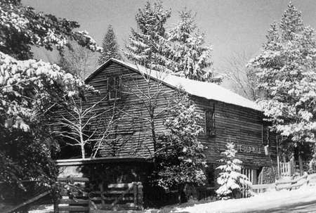
Maxwell’s Mill
Nearby Maxwell’s Bridge where Twyn Rivers Drive does its second bend are the ruins of a grist mill named “Maxwell’s Mill”. The site was built by a James Maxwell in the 1800s. In 1923, Maxwell sold it to Clarence Purcell who used it to raise livestock on his Twyn Waters ranch.
Twyn Rivers from Illustrated Historical Atlas of the County of York, 1878. Maxwell’s Mill is the Grist Mill labelled on his lot. Source: Old Toronto Maps.
James Maxwell from Nason’s east and west ridings of the county of York or townships of Etobicoke, Markham, Scarboro’, Vaughan & York directory, 1871. Maxwell is listed as a flour mill freeholder with a Post Office at Rouge Hill. His plot of land was located at Concession 3 (now Sheppard Avenue) on lot #2. Source: Toronto Public Library.
MEN OF TREES FAIR AT ‘TWYN WATERS’, Globe and Mail, September 24, 1941. Source: Toronto Public Library and Globe and Mail Archives.
The mill closed in 1929 after a flood weakened it and a fire in the 1970s destroyed much of what remained. Some of the foundations and walls still stand today. An image of Maxwell’s Mill is available on the Scarborough Historical Society’s website.
Mill stone at the Rouge river Twyn River Estate. Toronto, Ont., 1957. Source: Toronto Public Library
The Rouge Valley Inn & Caper Valley Ski Hill
The Rouge Valley Inn (later called the Rouge Valley Olympic Inn) was located on the south side of Twyn Rivers Drive slightly before the Scarborough-Pickering Townline. The site was a major Scarborough attraction in the twentieth century with a hotel, dining, picnicking for families, and “the largest swimming pool in Ontario.” Ambrose Small, the 20th century Ontario theatre titan who mysteriously disappeared in 1919, owned the Rouge Valley Inn for a time starting around 1900.
“Everyday Outings”, Globe and Mail, June 25, 1958. Source: Toronto Public Library and Globe and Mail Archives.
“Rouge Valley Guests” Globe and Mail, August 9, 1940. Source: Toronto Public Library and Globe and Mail Archives.
“$500 Reward,” Toronto Daily Star, January 6, 1920. Source: Toronto Public Library and Toronto Star Archives.
Across the Little Rouge Creek from the Rouge Valley Inn was the Caper Valley Ski Slope, also known as ‘Snake Hill’ for those who used to frequent it. Along with Earl Bales Park and other establishments, it was one of a handful of areas in Metro Toronto that offered the winter passtime. It was operated by Repac, whose name spelled backwards gave the ski hill its moniker. A footbridge linked the inn and the ski slope.
“School children taper at weekly ski outing”, Globe and Mail, January 6, 1972. Source: Toronto Public Library and Globe and Mail Archives.
Caper Valley Ski Hill, 1975. Source: Toronto Public Library.
Twyn Rivers Transformed
By the end of the 1970s, much of the historic landmarks of Twyn Rivers Drive disappeared from its geography. Fire claimed both the Rouge Valley Inn in 1968 and Maxwell’s Mill in 1970. The former site of the hotel is now the parking lot for the Twyn Rivers Rouge Park area. The mill’s ruins make for an interesting place for urban explores. Clarence Purcell sold his Twyn Waters ranch to the Metro Toronto and Region Conservation Authority in 1970, which after Hurricane Hazel in 1954 began to buy other valley and ravine properties for parkland. Today, there are very few residences located in Rouge Valley.
Twyn Rivers Drive, 1953 & 1975. Source: City of Toronto Archives.
By 1973, the Caper Valley Ski Hill was reporting financial difficulty and it too closed by the end of the decade. It now makes for challenging hike in Rouge Park’s Mast Trail. Finally, the Glen Eagles Hotel was also destroyed by fire in 1990, and is now the Glen Eagles Vista park. The site was nearly made condos. Today, most of these are owned and/or managed by Parks Canada.
Glen Eagles Hotel Fire, 1990. Source: Toronto Public Library.
Twyn Rivers Today
Today, Twyn Rivers is quite the nexus for Rouge National Urban Park, being the starting and ending point of multiple trails. The first source of exploration can be enjoyed around the Rouge Park parking lot. The area is situated on the Little Rouge Creek where the foundations of a former dam still stand. A makeshift footbridge crosses the creek where one can walk in the lost tracks of skiers on Snake Hill.
The Orchard Trail
Near Maxwell’s Mill is the southern terminus of the Orchard Trail. The two-kilometre walk slinks within the forest where apple trees grow today. It also offers vistas of the Little Rouge Creek. A particularly stunning area is the ascent/descent near the north end of the trail.
Gem. Treasure. These rich descriptors are often paired with Rouge Park — and for good reason. The beauty and cultural and natural history make it a must-visit in Scarborough and Toronto.
In October 2017, Rouge Park, which previously fell under mostly provincial protection, was officially transferred to the federal government. The event completed a process to make it into Canada’s first National Urban Park administered by Parks Canada.The title says it all: massive green space within a busy metropolis. It’s not a new idea for Toronto, though. The City of Toronto’s Parks, Forestry, and Recreation Department’s motto, “City Within Park”, neatly captures the sentiment its own parklands and trails.
Rouge Park and its trails Credit: Rouge Park.
Rouge Valley’s physical landscape dates to the last Ice Age, when the retreating ice sheet covering the Toronto area left grooves, dips, basins, and indents in the land. This is how the landscape became hilly and flat, and also how we get water bodies. Lakes, rivers, and streams form as meltwater rushes to fill the “holes” in the land. Human activity began from this point with Aboriginal hunters and farmers making use of the valley.
Although evidence is perhaps scarce for the entire period, there was a now well-known Seneca Village Ganatsekwyagonlocated where the Rouge meets Lake Ontario. The waterway was a portage Carrying Place Trail, too. Ganatsekwyagon is a National Historic Site (although strangely listed under Bead Hill instead of its true name), which perhaps plays into the desire to include the Rouge lands under Parks Canada.
Map of Lake Ontario, ca. 1680. The villages of Teiaiagon and Ganestiquiagon appear in place of modern day Toronto at the Humber and Rouge Rivers, respectively.Credit: City of Toronto Archives.
Although there are many access points within Rouge National Urban Park, a popular locale is the Vista Trail, located off Zoo Road at Meadowvale Road — right across, well, Toronto Zoo. The ‘welcome centre’ is a gorgeous Victorian farmhouse known today as the Rouge Valley Conservation Centre. Operated by the volunteer-based Rouge Valley Foundation, the centre’s mandate is to promote and engage in environmental conservation and offer interpretive and education programming within the Park. The homestead itself was built as the 1893 James Pearse House.
The Pearse House is named for the family who came to amass several hundred acres of land in the Rouge River Valley, including the present plot of the Vista Trail and Conservation Centre. This is not the house’s original location, however; it was restored and moved here in 1995 through efforts of volunteers.
Rouge Valley area from the Map of the Townships, York, Scarboro, and Etobicoke, 1916. A winding Meadowvale is located in the centre. Names like Pearse, Sewell, Beare, and Reesor still are prominent names in Scarborough today. Credit: University of Toronto Map & Data Library.
European settler presence since the 1800s has had the most transformative effect on the land, with maybe the most changes coming after World War II. In the 1950s, the (Metro) Toronto and Region Conservation Authority was created to put greater emphasis and protection in the Toronto area’s natural ravines. A couple of decades later, the Riverdale Zoo moved from Cabbagetown to the Rouge, further reorganizing the land.
Rouge Valley, 1969-1975. Apple orchards belonging to Joseph Burr Tyrell came to be the site of the Toronto Zoo. Meadowvale Road was reconfigured to bridge over Rouge River as its main right of way. Its former course still remains as a portion of Kirkhams Road. Credit: City of Toronto Archives.
The Vista Trail itself is a scenic walk, offering a number of fabulous views along its 1.5 kilometre route. An observation deck in particular allows for a great panorama of the Carolinian forest within the Little Rouge River and its dale.
Its pathway winds through that forest on a central ridge-like formation. On either side, the land dips down to give one a great look of the trees and colours of fall. The trail itself rolls up and down with tree roots serving as defacto stairs.
But speaking to the urban park aspect, the Vista Trail passes through an open space where Gatineau Hydro Corridor power lines run above. It’s a reminder that despite the perceived seclusion, civilization is not actually that far way.
Like the Rouge Valley Conservation Centre, the Parks Canada team host various guided hikes through the Rouge’s trails, ranging from topics like bird watching to tree identification to the wildlife in the valley to even a social hike. These walks run in all seasons too, offering the chance to see what Rouge Park has to show year-round.
Guided or not, a walk through the Vista Trail might offer one the opportunity to engage in some ‘forest pathing’ or shinrin-yoku. The Japanese practice invites one to engage with his or her surroundings in a way to cleanse oneself and relieve stress. And indeed, a calmness follows from taking in all Rouge National Urban Park’s richness.


