Toronto was a brick-making town. Going through the city today, you would not realize it right away. This lost and remade industrial and natural geography is remarkable. Great clay refining enterprises from the Don Valley to Leslieville to Yorkville to North Toronto to the West Toronto Junction now carry transformed greenspaces or residential communities. The Evergreen Brick Works is one of those spaces.
Don Valley clay pits, part of Don Valley Brick Works (Toronto). James Blomfield. June 10, 1939. Credit: City of Ontario Archives.
The Don Valley Brick Works began operations in 1889 and lasted quite a long time, providing the literal building blocks for the city of Toronto until 1984 — not a long time ago. One can think of the Brick Works as the last bastion for smokestack-raising, pollution-spewing, heavy manufacturing in Toronto.
Don Valley Brick Works, Bayview Ave., w. side, s. of Chorley Park in Don Valley; looking s. from Chorley Park, 1952. Credit: Toronto Public Library.
Following its closure, much like a lot of discussions then and now in how to imagine the post-industrial metropolis, the Toronto and Region Conservation Authority and City of Toronto looked to expropriate former brickyard as public space. During this ‘transition’ time, the abandoned factory became a haven for urban explorers.
Don Valley Brickworks, 1986. Credit: Toronto Public Library.Brickworks, 1990. Credit: Toronto Public Library.
What came out of it was a rejuvenated community hub and parkland with a mandate for environmental sustainability and conservation, led through the efforts of Evergreen. Much of the complex still stands, showing off ovens and other former operations of the Don Valley Brick Works. Today, they make great event and exhibition space which house among other things a great farmer’s market. Only one of the four chimneys remain, though.
The Evergreen Brick Works is a locale full of discovery, starting with its artistic displays. A favourite of mine is “Watershed Consciousness”, which neatly showcases Toronto’s ravines as the sort of veins and life blood of the city. Fitting.
One quizzical installation is a giant pair of metal shoes. This is “Legacy (the mud beneath our feet)” by David Hind, an homage to geologist Arthur Philemon (A.P.) Coleman. Mr. Coleman got his boots dirty many times over at the Don Valley Brick Works, using the quarry’s north cliff to research Toronto’s Ice Ages. A nearby display, “A Rare Geological Study”, presents Coleman’s notes.
Map of Toronto and Vicinity To accompany part 1, Volume 22, Report of Bureau of Mines, 1913. Credit: University of Toronto Map and Data Library.The Pleistocene of the Toronto region Including the Toronto interglacial formation, 1932. Credit: University of Toronto Map and Data Library.
The allure of the Evergreen Brick Works is its physical landscape. Each step offers more discovery and new vantage points. Wandering deeper into the Weston Family Quarry Garden and its tall reconstructed wetland, the factory behind disappears, aside from the chimney.
Running between the handsome factory buildings is a channelized Mud Creek (which might be the best and worst name for a waterway in Toronto). There’s a more naturalized version of the stream as well, running under the great Governor’s Bridge as one moves out of the park.
Veering away from the marked trails, there is the abandoned Don Branch of the Canadian Pacific Railway, last operating in 2007. With the Belt Line Trail also nearby it’s the second ghost line of sorts at the Brick Works. Following the CPR tracks takes one to the Half-Mile Bridge, seen as one enters the Evergreen Brick Works.
Don Valley Brick Works, Bayview Ave., w. side, s. of Chorley Park in Don Valley; looking w. from Broadview & Mortimer Ayes. 1955. Source: Toronto Public Library.
Perhaps the most inspiring experience of the Brick Works is the view from above. Moving up the cliff one takes in the awe of the full expanse of the site, its winding trails and ponds below, and the houses of Rosedale overlooking the valley.
One can only take in this reclaimed natural landscape and think of its layered makeup. The intersection of industrial, geological, and environmental history make the Evergreen Brick Works make it a special place. A walk around it only proves that.
Gem. Treasure. These rich descriptors are often paired with Rouge Park — and for good reason. The beauty and cultural and natural history make it a must-visit in Scarborough and Toronto.
In October 2017, Rouge Park, which previously fell under mostly provincial protection, was officially transferred to the federal government. The event completed a process to make it into Canada’s first National Urban Park administered by Parks Canada.The title says it all: massive green space within a busy metropolis. It’s not a new idea for Toronto, though. The City of Toronto’s Parks, Forestry, and Recreation Department’s motto, “City Within Park”, neatly captures the sentiment its own parklands and trails.
Rouge Park and its trails Credit: Rouge Park.
Rouge Valley’s physical landscape dates to the last Ice Age, when the retreating ice sheet covering the Toronto area left grooves, dips, basins, and indents in the land. This is how the landscape became hilly and flat, and also how we get water bodies. Lakes, rivers, and streams form as meltwater rushes to fill the “holes” in the land. Human activity began from this point with Aboriginal hunters and farmers making use of the valley.
Although evidence is perhaps scarce for the entire period, there was a now well-known Seneca Village Ganatsekwyagonlocated where the Rouge meets Lake Ontario. The waterway was a portage Carrying Place Trail, too. Ganatsekwyagon is a National Historic Site (although strangely listed under Bead Hill instead of its true name), which perhaps plays into the desire to include the Rouge lands under Parks Canada.
Map of Lake Ontario, ca. 1680. The villages of Teiaiagon and Ganestiquiagon appear in place of modern day Toronto at the Humber and Rouge Rivers, respectively.Credit: City of Toronto Archives.
Although there are many access points within Rouge National Urban Park, a popular locale is the Vista Trail, located off Zoo Road at Meadowvale Road — right across, well, Toronto Zoo. The ‘welcome centre’ is a gorgeous Victorian farmhouse known today as the Rouge Valley Conservation Centre. Operated by the volunteer-based Rouge Valley Foundation, the centre’s mandate is to promote and engage in environmental conservation and offer interpretive and education programming within the Park. The homestead itself was built as the 1893 James Pearse House.
The Pearse House is named for the family who came to amass several hundred acres of land in the Rouge River Valley, including the present plot of the Vista Trail and Conservation Centre. This is not the house’s original location, however; it was restored and moved here in 1995 through efforts of volunteers.
Rouge Valley area from the Map of the Townships, York, Scarboro, and Etobicoke, 1916. A winding Meadowvale is located in the centre. Names like Pearse, Sewell, Beare, and Reesor still are prominent names in Scarborough today. Credit: University of Toronto Map & Data Library.
European settler presence since the 1800s has had the most transformative effect on the land, with maybe the most changes coming after World War II. In the 1950s, the (Metro) Toronto and Region Conservation Authority was created to put greater emphasis and protection in the Toronto area’s natural ravines. A couple of decades later, the Riverdale Zoo moved from Cabbagetown to the Rouge, further reorganizing the land.
Rouge Valley, 1969-1975. Apple orchards belonging to Joseph Burr Tyrell came to be the site of the Toronto Zoo. Meadowvale Road was reconfigured to bridge over Rouge River as its main right of way. Its former course still remains as a portion of Kirkhams Road. Credit: City of Toronto Archives.
The Vista Trail itself is a scenic walk, offering a number of fabulous views along its 1.5 kilometre route. An observation deck in particular allows for a great panorama of the Carolinian forest within the Little Rouge River and its dale.
Its pathway winds through that forest on a central ridge-like formation. On either side, the land dips down to give one a great look of the trees and colours of fall. The trail itself rolls up and down with tree roots serving as defacto stairs.
But speaking to the urban park aspect, the Vista Trail passes through an open space where Gatineau Hydro Corridor power lines run above. It’s a reminder that despite the perceived seclusion, civilization is not actually that far way.
Like the Rouge Valley Conservation Centre, the Parks Canada team host various guided hikes through the Rouge’s trails, ranging from topics like bird watching to tree identification to the wildlife in the valley to even a social hike. These walks run in all seasons too, offering the chance to see what Rouge Park has to show year-round.
Guided or not, a walk through the Vista Trail might offer one the opportunity to engage in some ‘forest pathing’ or shinrin-yoku. The Japanese practice invites one to engage with his or her surroundings in a way to cleanse oneself and relieve stress. And indeed, a calmness follows from taking in all Rouge National Urban Park’s richness.
Milliken District Park lies in Scarborough’s northern reaches, hugging Steeles Avenue East between McCowan Road and Middlefield Road. Its story includes the transformative move from farmland to suburbia, as well as its importance to the community both past and present.
The park’s focal point is Milliken Pond, famed for the great wildlife that frequent its waters – most notably, the trumpeter swans. If one is lucky, one might also catch a look at the great blue heron. (I don’t have the pleasure on this day.)
Beyond its great aesthetic, the body of water also serves a functional purpose as a storm-water management pond. According to The Toronto and Region Conservation Authority, which manages the larger Highland Creek Watershed (of which the park is part of), Milliken Park was built in a low-lying area, and this basin collects the run-off rainwater from the surrounding environment and deposits it into the Highland Creek via underground pipes.
Adjacent to the pond is a great bit of greenspace (and my favourite aspect of the park) called Milliken Forest. This wooded area predates the creation of Milliken Park and has remained in tact even when the farmland around it was redeveloped (more on this below). It joins spaces like Passmore Forest, Brimley Woods, and Wishing Well Woods as woodlots that exist as what I call ‘rural leftovers’.
Milliken Park before redevelopment, 1965. The area that became Milliken Park was Lots 22 and 23 of Concession Road 5, historically farmed by families such as the Mitchells and Myles’. That also looks to be a creek running through the western third. Credit: City of Toronto Archives.
While they aren’t the great expansive forests of the Don Valley or the more untouched areas closer to the mouth of the Highland Creek, these spaces are important. They are key as homes to wildlife and help to mitigate the larger impact urbanization has had to the Highland Creek Watershed as a whole. For people, they are gems and escapes.
Exploring Milliken Forest piques my interest in labyrinths (albeit sans a mythological beast in the middle). One walks with hopefully a general sense of where they are, but ultimately not knowing where one path may lead. There are several forks in the road, leading me to also think of the Robert Frost poem ‘The Road Not Taken’ about choice, regret, and self-discovery.
On the theme of discovery, moving out of the trees, I locate a cache placed within the park. Geocaching is a global scavenger hunt where individuals hide trinkets of many sizes and shapes in personally significant locales in hopes of drawing folks to those places. I would say Milliken Park is perfect for that — people should know about this place.
A gaze around and one can see this is a well-designed, well-utilized park. In addition to the variety of programming at the community centre, there are walkers, picnickers (barbeque, anyone?), people-watchers, children on various playgrounds, and athletes. A regular sight for a beautiful Sunday morning I imagine. This connection goes back to the intent of the park in the first place: to serve the great amounts of new residents. News articles at the time wrote about the integral part greenspace played in linking new neighbourhoods.
Globe and Mail, January 7, 1984. Credit: Toronto Public Library Globe and Mail Archives.
For historical context, the Millken Park area was subdivided in the 1980s, continuing a process that had been going on in Scarborough since the 1950s. Going through historical aerial maps, one can see suburbia marching northward with every decade. It’s interesting when you get to a year like 1975 and you see that a good part of the borough up until Finch Avenue has been populated, yet still a simple drive or even look north produces agricultural fields. It’s a weird in-between period for Scarborough. For the areas of North Scarborough around Steeles Avenue, it’s odd to think of them as fields as late as the 1990s in some spots.
Milliken Park and its subdivisions under development, 1985. The farmhouses look to be gone. The creek that might have ran through the property has been buried and the stormwater pond has taken shape. Previously two parallel roads north and south of Steeles Avenue, McCowan Road has been rerouted to curve through the intersection, eliminating the jog. To the south, Passmore Avenue (5th Concession) has been largely overtaken by housing and today only remains in segments.
Milliken Park looks to have been possibly created as a ‘deal’ between developers and local government to allow greenspace in new areas of suburbia. The article below outlines the design, planning, and marketability of new parks in new suburbs, and the views different cities and developers take on the form and utility of parks. It also states that Milliken Park was supposed to have ‘model farms’.
Globe and Mail, July 20, 1985. Credit: Toronto Public Library Globe and Mail Archives.
A final feature of the park is the beautiful meadow and garden area towards the northwest quadrant. The gorgeous space is prime for wedding shoots, which indeed happened on this day, or just quiet contemplation.
If I could sum up the new Berczy Park, it would be a heavy expression of changing landscapes mixed in with a bit of whimsy — in a city that perhaps needs a lot more whimsy. One gets that immediately with the cat greeting patrons on Scott Street.
Dogs populate the inside and outside of the pool, water cascading out of their mouths and into the bone-topped fountain. Well, there is one confused feline among the canines, too.
Part of the appeal of parks is the context they exist in. Think Withrow Park,Christie Pits, and Trinity Bellwoods and how crucial they are to the larger Riverdale, Christie Pits, and Queen West Queen neighbourhoods, respectively. While the revitalized Berczy Park is going to be huge in the Old Town-Downtown Core area, the interplay between the park and its immediate surroundings is most intriguing. Having the fountain and the 19th century streetscape to its south as a backdrop makes for a perfect scene.
Robert Rotenberg in Old City Halldescribes this stretch of Front East as having a “comfortable, almost European feel”. With the addition of the park, I think this holds even more true. In particular, the Beardmore Building, 1872, is my favourite of the row with its beautifully restored yellow brick and arched windows.
The existence of Berczy Park is bittersweet in that the triangular block was once filled with warehouses and shops like the Beardmore. Beginning in the late 1950s but accelerating in the 1960s, these historic rows were knocked down, became parking, and then finally usable public space in 1980.
The Gooderham (Flatiron) Building, St. Lawrence Neighbourhood, and the newly reopened Berczy Park (formerly a parking lot), then and now. pic.twitter.com/YcCIjXVjx2
It’s easy to lament the loss – and indeed, we should (a plaque showcasing the former streetscape, anyone?) – but at some point we should move forward and make the best with what exists. Fortunately, that point has been taken very well Berczy Park.
Looking east, above more seating and gardens, one sees the giant mural draped across the back of the Gooderham Flatiron Building. The artwork was commissioned for the opening of the park in 1980.
Below it, an art piece stands for the park’s namesake, William Berczy, a settler in the Town of York and the communities along German Mills Creek in Markham.
Then, there’s the Gooderham Flatiron Building itself, at one time the great headquarters of Toronto’s brewing and distilling industry. It’s perhaps the most imaged structure in the city. With the updated Berczy Park, it’s in a position to be captured even more.
While its lasting existence seems so natural, the Coffin Block actually manned the odd intersection before it. I would say this is a case where heritage replacing potential heritage was not so bad.
Wellington St. E., looking w. from Church St., 1888. Credit: Toronto Public Library.
Eglinton Avenue is Toronto’s east-west midpoint. It is the only street in the city (although took some doing in the 1950s and 60s to make it so) that traverses all six former municipalities. This attribute has made it perfect for a crosstown transit line. Although it was laid out in 1793 as the Third Concession from Lot (Queen) Street, I would argue that Eglinton’s form, at least from Yonge Street to Latimer Avenue, as we know it today does not begin to take shape until 130 years after it was laid out.
Might’s correct city directory map of Greater Toronto, ca. 1940. The extension across the Don River branches were completed by 1956. In 1967, Richview Sideroad in Etobicoke was absorbed into Eglinton Avenue when the two streets were joined via a bridge across the Humber River. Credit: Map and Data Library, University of Toronto.
This stretch of Eglinton Avenue west of Yonge Street and the surrounding area was historically part of the Village of North Toronto. Even though the village was absorbed into the City of Toronto in 1912, allowing it to reap the benefits of better service delivery, the street was still a sparsely populated dirt road. It wasn’t until the coming decades when Eglinton’s fields morphed into a mixed residential and commercial zone. By 1930, the road was paved and possibly widened.
Eglinton Ave, west from Yonge, October 19, 1922. Fonds 16, Series 71, Item 1637. Credit: City of Toronto ArchivesEglinton Avenue west from Yonge Street, April 23, 1930. Fonds 1231, Item 1646. Credit: City of Toronto Archives.
At Duplex and Eglinton stands a power station. The yellow-bricked structure was built in 1920 at a time of rapid expansion in Toronto. With the Toronto Hydro-Electric System (now known as just Toronto Hydro) becoming the only distributor of power in Toronto at the tail end of the 1910s, Toronto was experiencing the pressures of an electrified transit network and a growing population.
The Eglinton sub-station was one of many built in this era to cope with this demand, specifically serving the surrounding residential community and “the Metropolitan radial line on north Yonge Street and subsequently to the TTC Yonge route and Eglinton Carhouse in the area.”
Eglinton Sub-station, August 10, 1925. Fonds 16, Series 71, Item 3975. Credit: City of Toronto Archives
Related, a short distance across from the station, there’s a row of mid-rise apartments. The positioning of these 1930s Art-Deco inspired buildings one after the other leads one to conclude that this was by design, although I wonder at their context considering the larger history the Toronto has with this kind of housing stock.
One historical narrative has been that whereas at the time the City of Toronto avoided this housing style, outlying communities like York and Forest Hill including them in their planning. For example, a more prominent row of these decorative lofts exists further west on Eglinton near Bathurst Street in the former Village of Forest Hill. These ones close to Yonge would have existed on land already annexed to the city, though. Curious.
Next, Eglinton Park has a neat past. As Lost Rivers explains, long before its colonial period, Huron peoples occupied its land and the nearby area – notably, the site of Allenby Public School – in the 15th century. In more recent history, the park was a brickyard! Capitalizing on the clay beds created by the now buried Mud Creek, James Pears ran his establishment here beginning in the 1880s.
The Eglinton Hunt Club (foreground) & Pears Brickyard (background), looking southeast,1920. The Pears home (now gone) can be seen at the top of the image at 214 Eglinton Avenue. A water tower stood on Roselawn Avenue near Avenue Road. A communications tower is in its place today. Credit: Toronto Public Libary
The modern geography within the park shows off the layers of time: the ‘dug-in’ escarpment leading up to Oriole Parkway, the hilly topography of Roselawn Avenue. Pears formerly worked out of today’s Ramsden Park in Yorkville before moving up Yonge Street, which has similar rolling features. These are the former lives of our parks.
Later, with North Toronto annexed, the City of Toronto attempted to purchase the yard from Pears before outright expropriating it in 1922 when he refused. The entire exercise came at a time in the 1920s and 30s when the City’s Parks Department was expanding, creating parkland and accompanying infrastructure such as shelters, gazebos, and bandshells. In fact, the Toronto Archives has a wonderful collection of ink & pencil drawings as a part of an Architectural Drawings Scrapbook prepared by the Department of Buildings for the Department of Parks and Recreation.
Eglinton Park (Roselawn Avenue) Shelter, August 12, 1930. Fonds 200, Series 372, Subseries 1, Item 934. Credit: City of Toronto Archives.
Pears’ legacy did live on for a while as the space was unofficially known as Pears Park for a time (and still might be?). Modern amenities have been added to the park since then of course, including a community centre, playground, and a Cretan maze via the Toronto City of Labyrinths Project!
A final sign of the street’s arrival was the eventual population of the street with commercial activity. The north side of Eglinton east of Avenue was one of the first retail blocks, coming to us around 1930.
CANATCO house index map of Toronto and environs, 1932. Credit: University of Toronto Map & Data Library.Eglinton Ave. north side Avenue Rd. looking east, April 23, 1930. Fonds 200, Series 372, Subseries 58, Item 1223. Credit: City of Toronto Archives.
With the opening of the Eglinton Theatre in 1936 to serve the growing local community, another commercial dimension was added. Neighbourhood theatres were abundant in Toronto by World War II, but The Eglinton was a benchmark in grandeur.
Whereas other ‘nabes‘ were more low-key in aesthetic, the Kaplan and Sprachman-designed Art Deco movie house and its neon-lit tower announced itself on the commercial strip. It’s amazing considering this was also during the Great Depression. It was operational until 2002, remarkably late in the history of comparable theatres. Today it’s the Eglinton Grand.
It’s all about the layers in the East Don Parkland. The residual landscape from the last Ice Age, the ravine, which stretches from Leslie and Steeles to Don Mills and Sheppard, has come to see pre-contact wilderness, colonial farming and industry, and post-war revitalization and reconfiguration.
But ‘East Don Parkland’ is a bit of a misnomer if only because it encompasses not only the east branch of the Don River but another – albeit smaller – tributary waterway.
German Mills Creek originates just to the north of Steeles in its historic namesake Markham community (sadly, now lost). The label is pretty literal, too: German Mills was once an industrious village along John Street founded by Bavarian-born William Berczy and a group of his countrymen and women. In addition to being a prosperous settlement, the community was instrumental in the early development of York too. The goods supplied by the mills aided in constructing the actual built form of the young town. The German Mills pioneers also cleared Yonge Street from Eglinton to Thornhill before the Queen’s Rangers finished the job.
East Don Parkland became part of Toronto’s parks network in the 1980s after efforts to remediate and rehabilate a river that had been worn out by European activity. Today, it is home to a number of flora and fauna, most notably salmon and white-tailed deer, the latter which are prominently displayed on the park’s signage. A neat tidbit: the deer’s precense in Toronto dates back to around 9000 years after the end of the last Ice Age.
Cummer Avenue bisects (or trisects?) East Don Parkland and offers more history. Unsurprisingly, the street’s name plays homage to the family who toiled around and built it – although to different designs.
Jacob and Elizabeth Kummer (the name was inexplicably changed to a ‘C’ around 1820), like the pioneers of Markham were of German descent, and came to the Toronto area in 1795, first settling near Yonge and Eglinton. They would relocate further up the main street to Willowdale where they would amass an extraordinary fortune. Their original property was a 190-acre lot fronting Yonge and stretching to Bayview. With subsequent generations of Cummers, their holdings grew to encompass not only large plots fronting Yonge but portions of the East Don Valley too. Whereas the former real estate was good for farming and commercial activities, the power of the river allowed the Cummers to engage in some industry. In 1819, they built and began operating a sawmill.
The Don property was interestingly significant in that early settlers as well as First Nations peoples took part in church and camp activities there. Through the meetings, the area was famously known as “Scripture Town” and “Angel Valley”.
East Don from Tremaine’s Map, 1860. Source: Toronto Historic Maps.
Around the 1850s, Jacob III, grandson of Jacob Kummer, built a farmhouse to overlook the valley. The home isn’t perfectly parallel to the street it rests on, making it a bit of an intriguing anomaly with the surrounding post-war subdivision.
To connect the Cummers’ Yonge and East Don holdings, a side road was constructed. Today, we know that road allowance as Cummer Avenue. Where the street crossed the East Don, it veered south to follow the curve of the river on its way to Leslie Street. The aforementioned mill was also located near this junction.
East Don River and Old Cummer, 1950. Source: City of Toronto Archives.
In the mid-1960s, Cummer was re-oriented away from the valley. A bridge that used to carry car traffic across the river serves as a reminder of its former course. One has to think of the vehicular ghosts when traversing the recreational trail that replaced the street.
A paved portion also leads to Old Cummer GO Station, where the street once passed through before the station’s construction in 1978. For years I puzzled about the station’s name.
South of Finch Avenue, with golden foliage of fall to accentuate the walk, the trail winds on.
So does the river, although not as it once did. Like Cummer Avenue, the Don’s history has come with some alterations. Along the way is at least one algae-covered oxbow – an orphaned or even ghost segments separated from the river’s course. This particular one was severed around the early 1950s.
East Don River, 1950. Source: City of Toronto Archives.East Don River oxbow, 1965. Source: City of Toronto Archives.
One has to note the monstrosity of human construction that is the CNR Richmond Hill GO line looming above the park.
A fallen tree trunk spanning across the river instantly urges me of more pioneering connections. It reminds me of an Elizabeth Simcoe depiction of an early bridge across the Lower Don River.
Winchester Street, bridge over Don R. (Playter’s bridge), 1794. Source: Toronto Public Library.
Finally, at the park’s southern end is Old Leslie Street. Just like Old Cummer, Leslie used to take on a different route. Heading south, the street used to jogged west at Sheppard before continuing south, all presumably to avoid crossing the Don River.
Sheppard and Leslie, 1961. Source: City of Toronto Archives.
The junction of Old Leslie and Sheppard was the nexus of the tiny, lost mill community of Oriole, named for George S. Henry’s homestead located off the Betty Sutherland Trail.
Old Leslie Street and Sheppard, 1956. Source: Toronto Public Library. Oriole Wesleyan Methodist Church stood on the southwest corner from 1873 to the 1950s.
By 1969, the street was rerouted directly through Sheppard. Old Leslie remains mainly as a service road for the Leslie TTC Station, terminating across from North York General Hospital.
The Scarborough Bluffs are Scarborough’s claim to fame and claim to name. Although the southern part of borough and its winding main streets are another world to me personally, I know that in the general consciousness of Torontonians, the Bluffs usually come up in Scarborough word association. Or, at least, they should.
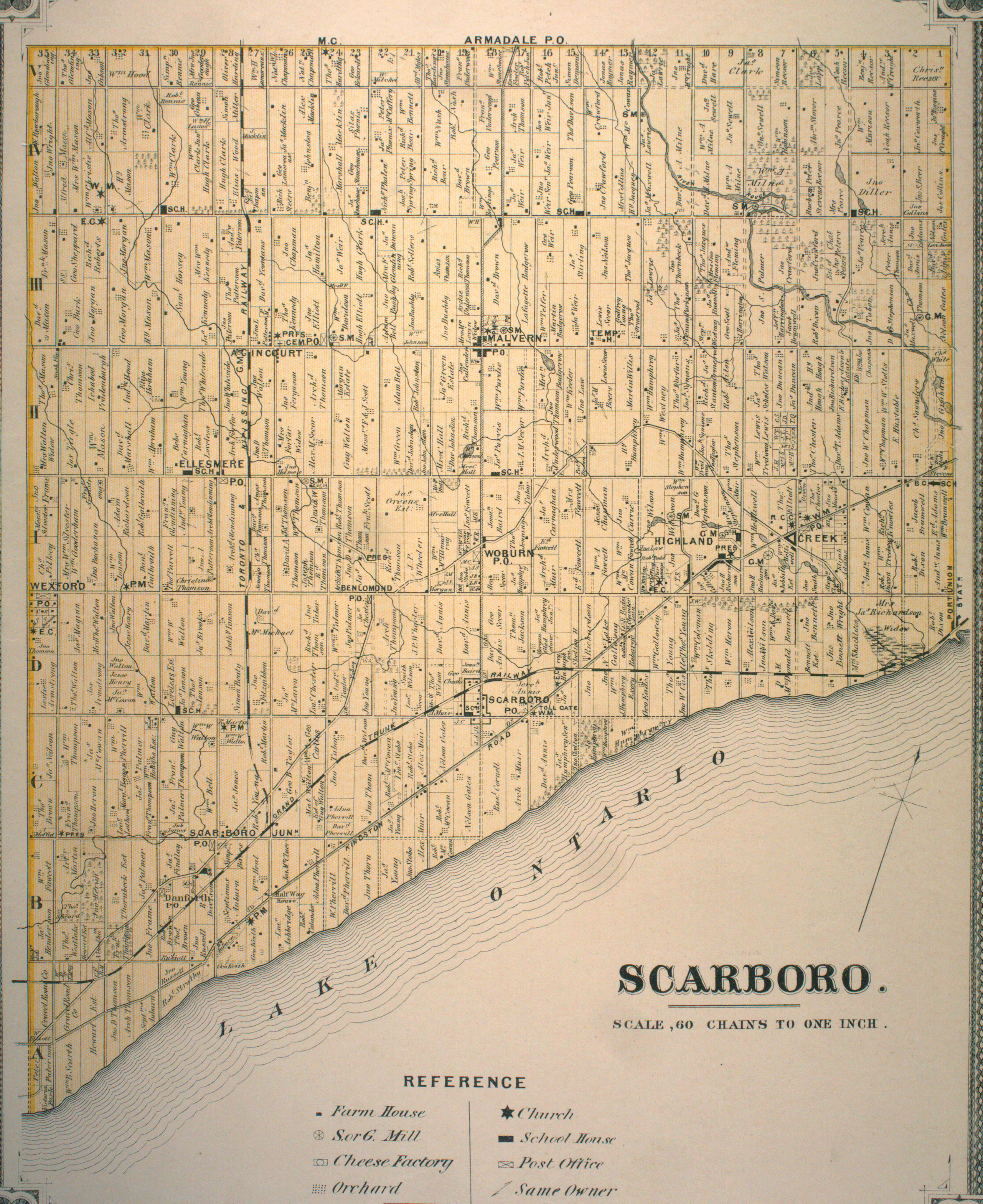
The built form of the southern end of Scarborough is a result of the Bluffs, including Kingston Road, whose course roughly follows the top of the landform. Laid out in 1817, it is one of the oldest European routes in the borough. In a pre-401 world, Kingston Road was the highway in and out of Toronto from the east. Its existence made it ideal for hotels and inns to aid travelers in their voyages. Some motels still dot the street today.
Map of Scarborough Township, c. 1916. Source: University of Toronto Map & Data Library.
Halfway House, Kingston Road & Midland Avenue, c. 1920. The building is currently situated at Black Creek Pioneer Village. Source: City of Toronto Archives.One notable landmark near Birchmount Road is not a rest stop but Scarborough Arts. The non-for-profit arts organization has a mandate “to create and cultivate innovative arts and cultural programs in Scarborough.” It’s a good one.
In addition to facilitating and promoting artistic programs, Scarborough Arts also has rotating exhibition space, appropriately named the Bluffs Gallery. In March 2016, its showcase was ‘YEARBOOK’, a brilliantly-conceived and -executed exhibit which utilized high school yearbooks to tell Scarborough’s history and its remarkable demographic change in particular.
It’s not a surprising discovery, but Scarborough didn’t begin to really diversify until around the 1980s. In addition to offering demographic snapshots, I enjoyed the cultural tidbits that could be gleaned from the yearbooks, such as what kind of school clubs existed and the advertisements of local businesses of the day.
Agincourt Collegiate Institute yearbook, 1964. I attended and graduated from the school some 50 years later.
The Scarborough Arts office is a little unconventional in that it is housed in a converted 1920s dwelling. Its ‘backyard’ is the Harrison Properties, which makes up part of the Waterfront Trail and whose name strikes me as having some sort of history perhaps relating to a previous owner of the lot. I’ve found nothing on the topic, however.
The park backs onto the Bluffs, although a fence and a warning blocks access to the ridge for safety reasons. More on that later.
Further up Kingston is the Rosetta McClain Gardens. The backstory of this gem is fortunately known and offered up in a couple of plaques. Rosetta McClain once owned this land, and upon her death, her husband and son gifted the lot to the City of Toronto for a public park. Interesting to me in the story is McClain’s father was in charge of the J & J Taylor Safe Works operation in Old Town.
The gardens are naturally a better a sight in the summer, but even in spr-winter the awe of the space is evident.
The frame of the old McClain house also still stands in the park as a monument…and as a backdrop for wedding shoots.
Access to the Bluffs themselves can be tricky and elusive. There are many’a sign on local streets south of Kingston which advise people to, well, go away. It reminds me of the ire of local Hollywood residents concerning tourists trying to get to the Hollywood sign.
Fortunately, there is a path beside Wynnview which leads down to Scarborough Heights Park. The bottom of the steep trail delivers a great view. The eye can follow the curve of the Scarborough coast as seen in maps as well the endless blue expanse of Lake Ontario.
This is easier going down than up.
Scarborough Heights Park, 1911. Source: City of Toronto Archives.
The way is long and muddy (and marked with bricks), but the reward at the end is worth-while.
These natural wonders are the leftovers of Glacial Lake Iroquois, whose geography is apparent throughout the city, most famously along the Davenport escarpment near Casa Loma. They are the same Bluffs that might exist in unknown narratives of Aboriginal settlement in this part of Scarborough. And they are the natural wonders Elizabeth “Don’t-Call-Me-Lady” Simcoe sailed past in 1793 which reminded her of her English home.
Of course, the elements and human activity have taken their toll on the Bluffs today, robbing them of stability and their chalky exterior in some places. I might argue their erosion is, though, a good – albeit, unfortunate – marker of time and a reminder of their history and pre-history.
Scarborough Bluffs, 1909. Source: City of Toronto Archives.
One thing that has remained consistent about the Bluffs is the marvel surrounding them. Sometimes it is hard to connect to bygone times and the psyches of people who lived within them, but human feeling and intelligence was no less primitive one hundred years ago than today. The people who explored Scarborough’s coast for an afternoon outing likely thought and felt the same as us when we do the same. That’s a comforting idea.
Scarborough Bluffs, 1915. Source: City of Toronto Archives.
The Bluffs of course stretch beyond Scarborough Heights for more stunning views, including across the way at Scarborough Bluffs Park. But that’s another day.
Consider this a sequel. Or, maybe a prequel. Whatever the case, if Wishing Well Acres is the Sullivan in Tam O’Shanter-Sullivan, here’s the Tam O’Shanter part.
We begin at Agincourt Mall. The shopping centre dates back to 1966, likely making it the third enclosed mall in Scarborough after 1954’s Eglinton Square and Golden Mile (Cedarbrae Mall predates Agincourt by four years but didn’t get its ceiling until 1972). The mall’s anchors are Wal-Mart and No Frills, but I can recall a time – in 1994, specifically – when they were Woolco and Loblaws, respectively. Walmart bought Woolco that year. No Frills came in the 2000s.
As much as malls like Agincourt are seen as shabby and sad (Agincourt Mall as of 2016 has a number of empty tenants), I’ve found that they are still appreciated locales. A lot of nostalgia fills their walls. The comments in this BlogTO article about Agincourt Mall by Robyn Urback prove that. Everyone has a story, or a store they enjoyed frequently, or an odd memory about something that isn’t there anymore. Mine is the RadioShack that was there in 1990s and 00s, reminding me of lost Canadian retailers. There is a Source in the mall now, but not in the same space as its predecessor.
Agincourt Mall was built on the Kennedy farm, with the farmhouse once located just north of the mall and south of the West Highland Creek. A walk down the street named for the family leads to a trail that lines the creek.
The path is sandwiched between an apartment and townhouse complex on one side and the creek and Tam O’Shanter Golf Club on the other. A look down at the shallow waterway produces a shiny sheet of ice over the surface and the occasional group of ducks in the non-frozen bits. But there’s also something that doesn’t quite belong.
Several pillars jut out on either side of the creek – two on one side and two opposite them. I count three sets of these abutments along the way. Their meaning isn’t hard to figure out: 3 sets of abutments, 3 phantom bridges. There is one question, though: what’s the story?
The answer: In the 1930s to the 1970s, this was the site of the Tam O’Shanter Golf and Country Club, the precursor to Tam O’Shanter Golf Course.
In addition to golf, the Tam O’Shanter Country Club complex had swimming, ice hockey, and curling. In 1971, the club erupted in flames, destroying some of the complex. In researching the fire, I’ve read many stories about people seeing the flames from afar. Like Agincourt Mall, the country club meant something to many people.
In 1973, the Province of Ontario, Metro Toronto, and Scarborough jointly acquired Tam O’Shanter and converted it into a municipal golf course. In the coming years, the complex would be gradually demolished and a new clubhouse would be built around 1980. Today, a couple of apartment towers on Bonis Avenue stand in the club’s former location.
Tam O’Shanter & West Highland Creek, 1967, Source: City of Toronto Archives.
Back to the abandoned abutments, the creek was located just behind the clubhouse and its bridges led to and from the golf course. Shortly after the course’s acquisition, the bridges were removed, presumably because the course layout would be reorganized.
But the creek hasn’t always run the same course.
Tam O’Shanter & West Highland Creek, 1956, Source: City of Toronto Archives.
The West Highland at one time swung north up into the golf course before dropping back down and resuming in a northwest direction. Around 1967, the creek was straightened and bridges were installed. The orphan bend remained as a sort of oxbox for some time, but since has been mostly filled in. One can still see the imprint of the bend today, though, notably through the pond and the ‘etched’ curved outline north of it.
Tam O’Shanter & West Highland Creek, 2015. Source: Toronto Historic Maps.
There is one remaining bridge, however – a wider, sturdier construction. There is a gate in the fence on the other side, so one can guess that at least it might have been a vehicular corridor. As of 2015, though, both ends have been barricaded to prevent any sort of use.
As the West Highland continues into the golf course and beyond, the trail comes to Ron Watson Park, renamed from Tam O’Shanter Park in 2005 in recognition of the long-time Scarborough resident, trustee, and councillor. Watson was honoured with a star on Scarborough’s Walk of Fame in 2011. The park forms the field of Tam O’Shanter School, featuring a nice playground…and a stone turret.
This viney tower became an instant curiosity to me. It looked old and misplaced. No doors (although, perhaps a sealed opening), a couple of ‘windows’ near the top. What was/is it?
I had to do some digging. Google presented nothing, so I consulted some aerial photos to try and date it. It’s been around since at least 1947, the first year on record for aerials in the Toronto Archives.
Charles Watson Farm, 1965. Source: City of Toronto Archives.Ron Watson Park, 2015. Source: Toronto Historic Maps.
So, Horsey sold his farm to Watson, who likely built the silo. When Watson’s farm was subdivided, the tower was never torn down with it. My guess is the task proved too difficult. It doesn’t fully answer the ‘when?’ part, but mystery solved!
Leaving the park and silo, the two-in-one Stephen Leacock Collegiate/John Buchan Senior Public School has had a place on Birchmount Road since 1970. It is built in the Brutalist (or, Heroic) style that was indicative of Toronto architecture in the 1950s to 1970s. The schools’ namesakes were a Canadian author and humourist and Scottish author and historian, respectively.
And while I’m profiling, Tam O’Shanter is a Robbie Burns poem. Another Scottish connection. The Anglo-Saxon roots and references of the Tam O’Shanter community is interesting though, considering what it became. Today, it is one of the more diverse areas in the city of Toronto.
Next, a derelict structure stands across the school. I don’t know its full context, but it’s most definitely another rural leftover.
On Bonis Avenue, there’s Agincourt Library and another great turret. Although the building opened in 1991, the library itself dates back to 1918. Within that time it has moved locales a few times, including a stay in Agincourt Mall. The branh carries three copies of A History of Scaborough. Its editor is a Mr. Robert Bonis, who lends his name to the street.
Down at Birchmount and Sheppard, a strip mall has gone through a makeover in the last few years. It’s about to get a new tenant, too: Starbucks. The sight is initial shock for me, if only because it’s strange to see one in this neighbourhood. My mind shoots to the old idea that a Starbucks is tell tale sign of gentrification, but I question whether it applies here. We’ll have to see.
Foregoing a stroll down Sheppard, I backtrack to Bay Mills Boulevard. The curved street offers a sort of ‘backstage’ view of Tam O’Shanter, showing off the apartments, church, school, field, playground that all front Sheppard. The intersection of Bay Mills and Sheppard is the start of the Sheppard Avenue East Avenue Study zone. On one side there’s another strip mall; on the other, a car dealership. They’ll surely be part of the plans.
Warden Avenue is further down the way, but that adventure lies in the mentioned Wish Well exploration. For now, that’s a wrap on this one.
If you have memories of Agincourt Mall, Tam O’Shanter Country Club, Stephen Leacock School, or Tam-O’Shanter-Sullivan in general, I would like to hear about it. Leave a comment below or tweet me!
The area between Highway 401 and Sheppard Avenue East, Warden and Victoria Park Avenues has got a bit going on. A strip-mall and apartment lined main street, a winding neighbourhood of bungalows to its south — it’s unmistakably suburbia. The rise of its subdivisions following World War II, the effects on the natural and built environment, and its pending evolution make it an area of interest.
First, from its beginnings as the narrow, dirt covered Concession Road III to its wide, strip mall-lined incarnation after WWII, Sheppard is about to get another layer.
Sheppard East is an avenue, but it’s also an Avenue – at least, if you ask Toronto city planners.
Avenues are corridors which have been identified to help accommodate Toronto’s growth. Avenues like Sheppard have to be rezoned to handle more density and this is done through midrise construction. The result are livable, walkable, transit accessible, mixed use communities outside the downtown core. A Sheppard Avenue East Avenue Study sets out the upcoming changes.
As suburban arterials transform to become people-oriented places, cycling, walking and transit become real options. pic.twitter.com/x2rZCBy1PI
The centre of this transformation is the Sheppard and Warden intersection. On one corner, a car dealership sits empty – and has for a while, as far as I can remember – and awaits development. A muralled box by Katherine Laco colours the corner as well.
On another corner, the aptly named Warden-Sheppard Plaza looks like it might be razed as well. I remember this mall for its longtime archor, the Galati Brothers supermarket, now Food Depot Supermarket.
South of the Sheppard to the 401, the residential neighbourhood also sports some layers. It’s a bit of a name game to identify this neighbourhood. Tam O’Shanter-Sullivan (or simply Sullivan) marks the larger area in the Scarborough-Agincourt federal and provincial ridings. Just to narrow it down, though, I’ll elect to use the Wishing Well Acres moniker after one of the subdivisions.
This area between Warden and Victoria Park Avenue historically consisted of three 19th century farms: one by Ichabod Vradenburgh at Concession II Lot 33, another by Christopher Thomson at Lot 34, and finally one by Thomas Mason at Lot 35.
Source: 1878 Illustrated Historical Atlas of the County of York.
Ichabod Vradenburgh was born in 1815, and emigrated from New York some time after. He married Jane Thompson, a Scarborough native, and had six children. The Vradenburgh name is pretty well represented in the new neighbourhood – sort of.
Vradenburgh development, 1965. Source: City of Toronto Archives. The northern half of the plot, consisting of Palmdale Drive (above picture) and Warden-Sheppard Plaza, is constructed by 1975.
Vradenburg Junior Public School was built in 1957, which was approximately year the community starts to take shape. By the looks of its large windows, it follows the Modernist design of John B. Parkin’s 1942 Sunnylea Junior Public School. Vradenberg Drive and Park also bear the family name, although with an inexplicably vowel swap and consonant removal.
Today’s Castleford Drive roughly marks the border between Vradenburgh’s property and Christopher Thomson’s Wishing Well Farm. Thomson was named after his Scottish father, who was one of the first settlers in Scarboro Township and who rose to a respected position locally. Christopher’s mother, Mary, was a native of York, Upper Canada. According to the Scarborough Historical Society, Thomson settled here in 1827 and the name of his farm derived from his hope to plant a well on his land. When he finally hit water, he called it Wishing Well Farm.
Wishing Well Acres, 1956. Source: City of Toronto Archives. North of Sheppard is Harry C. Hatch’s indoor racetrack. On the south side of Sheppard is Wishing Well Woods.I always feel like I’m taking a secret passageway anytime I encounter paths like this.
Wishing Well Acres, the subdivision that rose out of the farm in 1956, is notable for housing Canada’s Millionth Post-War House, a bungalow on Beacham Crescent also built in 1956, needless to say, marked a watershed moment in suburbia.
Hidden behind a strip mall at Pharmacy and Sheppard is Wishing Well Woods. Like Brimley Woods and Passmore Forest, this woodlot is what I like to call a colonial remnant or a rural leftover – a patch of 100 to 200 year old forest on a farming parcel which survived redevelopment after WWII. Of course, these remnants never seem to prevail fully in tact, especially in the case of Wishing Well Woods. Compared to Brimley and Passmore Woods, though, this collection of trees isn’t much of a woodlot. That said, green space is green space and losing it would be a loss.
The mentioned strip mall at Pharmacy and Sheppard looks like it has development in its future. Hopefully that doesn’t affect Wishing Well Woods.
The Pharmacy and Sheppard intersection is no stranger to redevelopment. North of Sheppard is the Bridlewood neighbourhood, which gets its name from the indoor racetrack once located at the northeast corner. It was built for Harry H. Hatch, a distiller with a hand in the Gooderham & Worts empire and a championship horse breeder. The racetrack was torn down in 1958 and the Bridlewood development was subsequently constructed.
South of Sheppard, Pharmacy Avenue takes on a narrower, sparser form than north of it. Historically, it ran through the area now occupied by Highway 401, but since the highway’s construction in the early t0 mid-1950s, it dead ends just north and south of the expressway. One supposes with its proximity to Victoria Park, a bridge at Pharmacy wasn’t needed.
Wishing Well Park occupies the foot of Pharmacy. Anyone traveling westbound on the 401 near Victoria Park is at least familiar with Wishing Well and its baseball diamonds.
But today’s baseball fields is yesterday’s farmfield, specifically Thomas Mason’s barns. The post-Mason farm development to the north, constructed around 1955, is named Town & Country. Information about Mason himself and the root of this naming is scarce, but if I had to guess, it might be because of the duality of (sub)urban and rural at the time.
Further to the story, Wishing Well Park also once contained the headwaters to Taylor-Massey Creek, a slinking waterway that shows up in Warden Woods Park and the former Massey property in today’s Crescent Town. Today’s headwaters are located south of the highway after the original were buried and diverted to Highland Creek.
Town and Country, 1956. Source: City of Toronto Archives. Taylor Massey Creek cuts diagonally through Wishing Well Park, then still a farm.
As signs of its one time existence, one can pick out Taylor Massey Creek’s topographical imprint on the park. Moreover, streets like Meadowacres Drive pay tribute to it.
Up on Victoria Park, Consumers Road and area is home to a large employment district in Toronto and a few company headquarters, including Universal Music and the street’s namesake company, Consumers Enbridge Gas.
Like Sheppard East, the area is set for redevelopment with the ConsumersNext project. As a huge locale for jobs, Consumers Road Business Park is currently zoned as an employment area, but the environment isn’t very navigable sans an automobile. Among its goals, ConsumersNext will make the Business Park pedestrian- and transit-friendly.
Consumers Next Map. Source: City of Toronto City Planning.
Within the ConsumersNext lands is the recently named Ann O’Reilly Road. The new street contains an interesting bit of local, hidden history. O’Reilly was an innkeeper who, in 1860, along with husband, Patrick O’Sullivan, opened a hotel on the northwest corner of Victoria Park and Sheppard (now Victoria Park Square).
The intersection and area became known as O’Sullivan’s Corners after Ann & Patrick’s son, Micheal O’Sullivan, opened a post office in the hotel in 1892. It’s a familiar origin story in Toronto: a post office (and/or hotel, in the case of O’Sullivan’s Corners) opens in an area and becomes a hub for the new community.
The inn/post office was torn down around 1954, and without its existence, O’Sullivan’s Corners seems to have fallen out of use. It’s a part of a long list of bygone neighbourhoods in Toronto. The grander community of Sullivan (sans the “O'”) seems to reference it, however.
Metropolitan Map of Toronto, 1955. Source: University of Toronto Map and Data Library. Note the routing of Sheppard Avenue at the top of the map. It once ended at Victoria Park Avenue. A separate street named Lansing Road curled down from Woodbine Avenue and straightened at Victoria Park before continuing into Scarborough. Around 1955, the two streets were merged to make the modern Sheppard Avenue. The ‘orphaned’ section between Woodbine (which became the 404 in 1977) and Victoria Park became Old Sheppard Avenue.
Today, though, there’s another landmark at the intersection: the famed Johnny’s Hamburgers, a fixture since 1967 which seems like it’ll endure whatever comes next for its surroundings.
As 2015 has come and gone, I think it’s an appropriate exercise to take stock of my year of exploring the city.
My adventures were concentrated once again within the borders of the Old City of Toronto, which was expected, because even in the context of the MegaCity, Toronto Proper still has many stories to discover and relay. A huge highlight was attempting to peel back of the layers of the Fort York area. For an area that has had two hundred years of history and is important in the grand story of Toronto, it’s development into a neighbourhood is only a recent development.
I took a similar approach in meandering through Yorkville, which has been a ‘village’ for more than a hundred years, but has layers of natural, industrial, cultural, and built heritage.
Towards the end of the year, however, I got outside of the downtown core and started to explore areas that were closer to home. This ultimately began with a guided Heritage Toronto tour through Etobicoke’s Sunnylea, but it really took off with a look into Passmore Forest and then shortly followed by Brimley Woods. The existence and evolution of these greenspaces and their environs in the context of Scarborough’s farming past and suburban present is fascinating. In the case of Passmore Forest, there’s even a pre-contact history with the Alexandra Site!
East York’s Crescent Town and North York’s Peanut and environs was a further investigation into suburbia, particularly in the history of tower building in Toronto. Although located in different parts of the city, both their constructions interestingly necessitated the extension of two main roads – Victoria Park Avenue for Crescent Town and Don Mills Road in The Peanut and area.
In regards to where I’ve been, in June I attempted to draw out Toronto from memory. In constructing this mental map, I identified the holes in my concept of the city. More than half a year later, the western reaches of the city still draw blanks. A resolution for 2016, perhaps?


![Half-Way House, Kingston Road. - [1920?]](https://i0.wp.com/scenesto.com/wp-content/uploads/2016/04/kingston-road-halfway-house-1920.jpg?ssl=1)