
In January, I looked at the origins of “Old” Streets of Toronto — that is, main Toronto roads that have the moniker “old” preceding their names. In many cases, these stories involved the re-routing of streets to create a more direct path for travellers. In doing so, the old paths were sometimes not eliminated.

Source: Old Toronto Maps
Created by: Bob Georgiou
Here are six (and a half) more “Old” Streets of Toronto and their quick histories:
Old Dundas Street
Year rerouted: ~1929
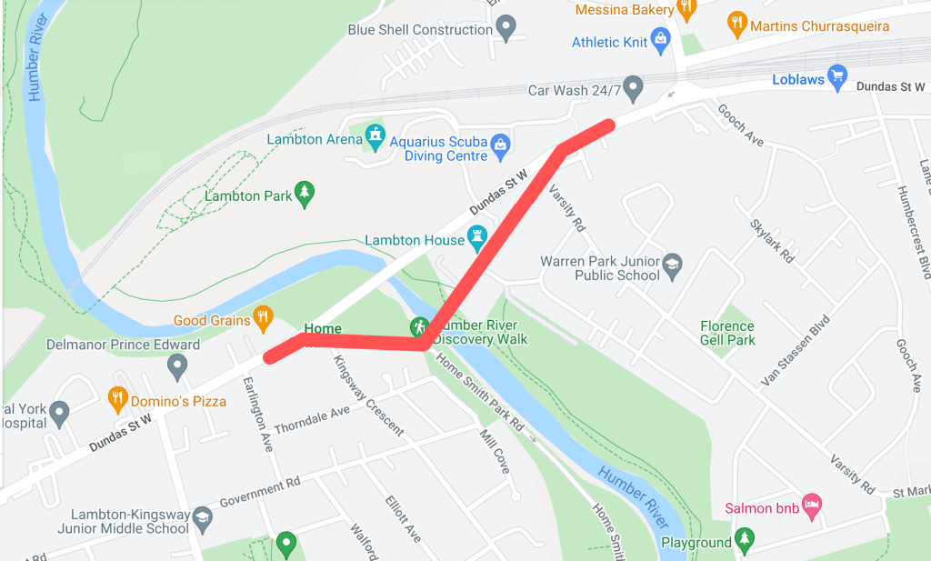
Historically, the main crossing over the Humber River on Dundas Street was located about two hundred metres south of the current bridge. This section of Dundas made up the old community of Lambton Mills and served as a main entrance into Toronto from the west on the Dundas highway. There were several versions of Dundas Street bridges here over the years — some made of wood, some iron, but all narrow for traffic and susceptible to the flooding waters of the Humber.

Source: Goad’s Toronto
In 1929, a new high-level bridge was completed over the Humber. This altered the main course of Dundas Street to the north. The old course became “Old Dundas Street”. For nearly thirty years, the two Dundas Street bridges existed alongside each other. In 1954, the devastating effects of Hurricane Hazel left the Old Dundas Street bridge in a dilapidated state; it was finally demolished several years later. Today, Old Dundas Street exists on both sides of the Humber River mostly as a quiet residential street. Lambton House, a historic inn turned museum, is a leftover of Old Dundas Street and Lambton Mills’ prominence.

Source: Globe and Mail Archives.

Source: City of Toronto Archives

Source: Google Maps
Old Weston Road
Year rerouted: ~1948

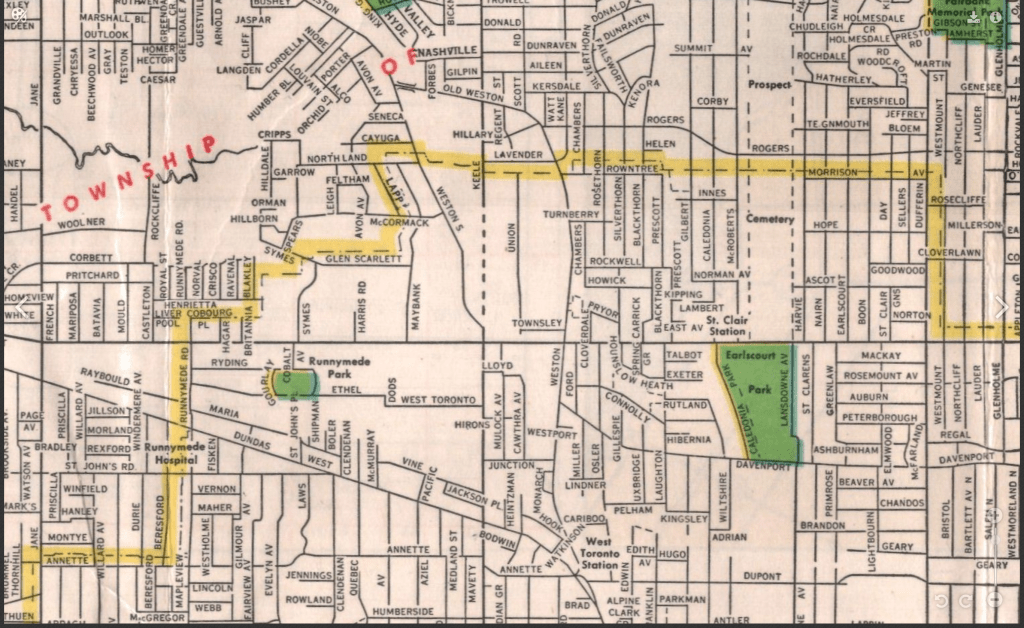
Weston Road takes an interesting route through northwest Toronto, running diagonally through its street grid from the historic town of Weston (makes sense, eh?) and creating some unconventional intersections. North of St. Clair Avenue, the route of Weston Road was historically located east of the present road on the other side of the train tracks. It made up the historic village of Carlton with St. Clair and Weston as its nexus. It is highlighted by the still standing, yet altered Heydon House Hotel, built 1890. Weston then ran south to join with Dundas Street.

Source: Old Toronto Map

Source: City of Toronto Archives
Around the 1890s, another “branch” of the street was built north from Keele Street running parallel to the railway on its west side. This street took on the name “Weston Road South”. In the 1910s, the street was completed to join with the main Weston Road.

Source: Old Toronto Maps

Source: McMaster University

Source: City of Toronto Archives
Perhaps because Weston Road South offered a more direct route south into the city, it formally became the more prominent road in the 1940s. First, an “Old Weston Road” began to refer to the section of Weston Road between the railway and Hillary Avenue. This meant that at one time a person could stand at the intersection of Weston Road, Old Weston Road, and Weston Road South. In 1948, Weston Road South became just Weston Road. Also, the entirety of the older eastern section of Weston Road was renamed Old Weston Road, save for the section between the tracks and Hillary which was added to Rogers Road. As the tracks to the south grew, the section of Old Weston near Dundas became severed from the rest of the road. Today, Old Weston Road is a mostly residential street.

Source: Old Toronto Maps
Source: University of Toronto Map & Data Library.

Source: University of Toronto Map & Data Library.
Old Eglinton Avenue
Year rerouted: ~1957

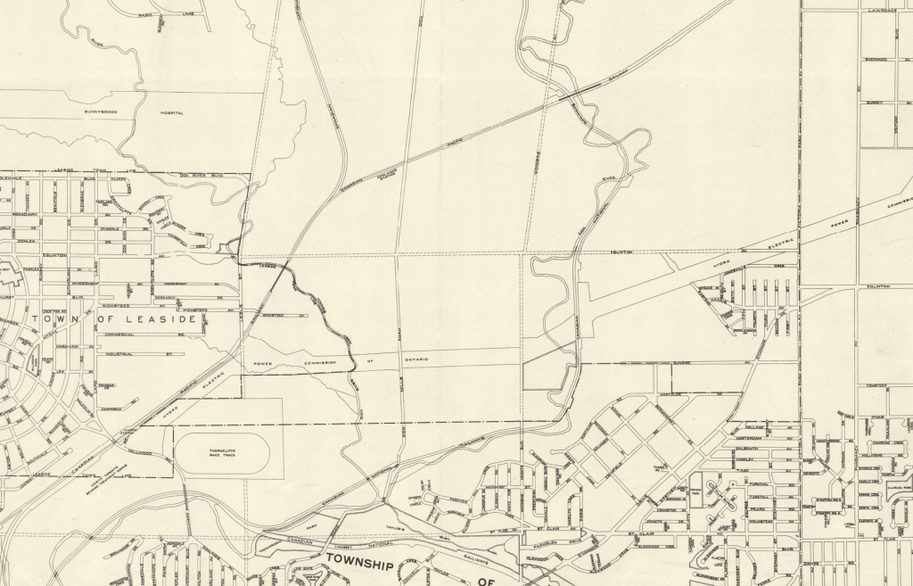
For an east-west street that has become so vital to Toronto’s street grid and home to many neighbourhoods, it is difficult to imagine that Eglinton Avenue did not always exist in one harmonious stretch of road. However, it took some doing to make it into the street of today. Until the 1950s in the eastern half of Toronto, Eglinton Avenue terminated near Brentcliffe Road in Leaside and did not resume again until Victoria Park Avenue in Scarborough. The area in between them was about a five-kilometre stretch of farmland and two ravines — that is, both the east and west branches of the Don River. In the mid-1950s, a massive project was undertaken to join the two sections.

Source: City of Toronto Archives
Source: York University Archives

Source: University of Toronto Map and Data Library
While an “Old Eglinton Avenue” seems to come out of the events of the 1950s, it seems a little unclear why. The street runs parallel to the “new” road for about half a kilometre west from Bermondsey Road. Like the surrounding area, it mostly houses industrial buildings. As Eglinton did not seem to exist between Leaside and Scarborough (at least not in any formal sense), the story of Old Eglinton is a bit of a mystery. Hiking The GTA has located an old roadbed for an “Old Eglinton Road“. This may have been a farm road or a line that divided farm lots. It is also notable how Old Eglinton Avenue aligns with a “pencilled in” Eglinton Avenue between Victoria Park and Leaside, so a theory may lay in that idea.

Source: City of Toronto Archives

Source: Google Maps
Old York Mills Road
Year rerouted: ~1972

The valley near Hogg’s Hollow has proven to be an obstacle to road transportation several times in its history. As I previously noted, Yonge Street was realigned in 1835 after skirting east to better tackle the West Don ravine’s topography. Because of this same geography, Wilson Avenue terminated at Mason Boulevard, meaning there was no direct east-west crossing at Yonge Street as we know it today. In 1972, a project was undertaken to extend Wilson to meet with Yonge and York Mills Road.

Source: City of Toronto Archives

Source: Toronto Star Archives
To make this extension happen, a curved road was constructed from Wilson Avenue which then crossed Yonge Street and joined York Mills Road between Campbell Crescent and York Ridge Road. This meant the straight section of York Mills near Yonge Street was effectively separated from the main route, becoming “Old York Mills Road”. Today, Old York Mills houses a trailhead, a passenger pickup zone for York Mills Station, a condominium, and a church.

Source: City of Toronto Archives.
Old Kennedy Road
Year rerouted: ~1987
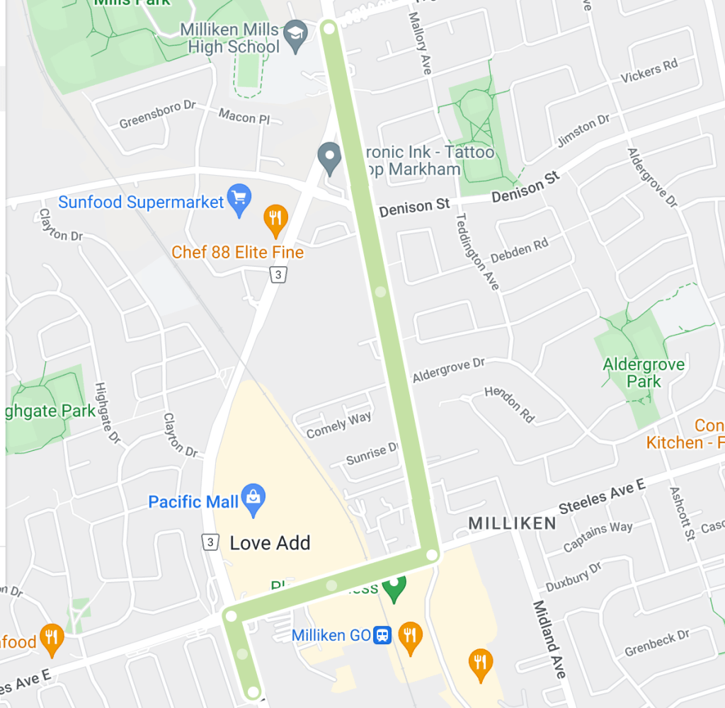
Kennedy Road just north of Toronto is a prime example of how of a noticeable curve in a street sometimes denotes a street was re-engineered. Kennedy existed in two separate sections north and south of Steeles Avenue, the Scarborough-Markham town line. The roads were about six hundred metres apart, meaning a northbound traveller from Scarborough had to jog east and then north again to continue into Markham. The area as a whole is and was known as Milliken, a historic community with the uncommon characteristic of existing within both municipalities.

Source: University of Toronto Map & Data Library
In 1987, the two sections of Kennedy Road were connected by a curving road running north from Steeles which veered east to meet the Markham section of Kennedy just north of the newly created Denison Street. The circumstances behind the re-alignment were unclear, but given Kennedy Road’s history as a ‘highway’ in Scarborough and the tendency in and around Toronto to harmonize streets within bordering jurisdictions, it is easily conceived why the jog was removed.

Source: City of Toronto Archives.
The eastern section of Kennedy became “orphaned” and was renamed Old Kennedy. Old Kennedy stops at Denison and continues on as Fresno Court, which in turn ends at a cul de sac. A fence separates it and Kennedy Road. Old Kennedy Road is an interesting mix of industrial and residential, with several older-looking houses near Steeles, perhaps lending back to the days when it was a hub in the village of Milliken.

Source: Google Maps
Old Finch Avenue
Year rerouted: ~1993

Finch Avenue in Scarborough is relatively straight for much of its course from the North York town line to the Pickering town line — except in its most eastern part. Where Finch passed through Staines Road, the street at one time did a triangular job around the CPR tracks (the detour seems to have been created in the 20th century).

Source: University of Toronto Map & Data Library

Source: Source: University of Toronto Map & Data Library
Further along, Finch did another jog up Sewell’s Road before meandering across the Rouge River and around its valley. It continued straight toward Kirkham’s Road (today’s Meadowvale Road). As there is today, there was an uncleared section of land across to Beare Road, thus one would have to jog up again to Plug Hat Road and back down to reach Finch again. The street resumed once more on its way to the Pickering Border. This stretch of Finch between Sewells and Kirkham’s made up the historic community of Hillside which had a church, school, and mill. The village made up much of the Rouge lands today from Sheppard Avenue/Twyn Rivers to Steeles Avenue.

Source: City of Toronto Archives.

Source: Toronto Public Library
By the 1980s, changes came to Finch Avenue. Morningside Avenue curved from the south to meet Finch. Then, in or around 1993, the street was extended further north of Finch. This changed the alignment of the Finch/Staines intersection and effectively split Finch Avenue. Travellers moving east on Finch had to now follow the curving street north to Morningside Avenue and then curve back south via the same street. The east-west street on the other side was “Old Finch Avenue”, following the older, winding alignment. Because of this, the street bunks the trend of “old” streets which were leftover sections of the re-routed street; there is/was not ever a “newer” Finch Avenue that existed alongside the street. Old Finch terminates at Meadowvale Avenue; after Beare Road, it becomes Finch again and continues into Pickering for another eight kilometres.

Source: Toronto Star Archives

Source: Toronto Star Archives

Source: City of Toronto Archives
Today, Old Finch is mostly known for its ‘haunted’ Bailey bridge and being the northern border of the Toronto Zoo, whose postal address is 361A Old Finch Avenue. The reconfiguration at Staines also facilitated the Morningside Heights neighbourhood.

Source: City of Toronto Archives

Source: Google Maps
The Older Finch Avenue
Year rerouted: 1977
Old Finch Avenue in the Rouge Valley was not the first Old Finch in the city. There was once a severed section of the street near Victoria Park in the old community of L’Amoreaux when the street was realigned directly across the Scarborough-North York border. This curved realignment eliminated a jog along the town line for east-west travellers. This Old Finch Avenue was closed in 1977; Pawnee Avenue roughly follows its old right of way.

Source: City of Toronto Archives

Source: The Globe and Mail Archives
For a Google map of “Old” Toronto Streets, click here.

Source: Google Maps
Created by: Bob Georgiou
If you have any information to add or have any stories from any of these locations, leave a comment below or email bob@scenesto.com!


