On May 6-8, 2016, Toronto will be hosting its tenth edition of Jane’s Walks. The festival features a large number of city-wide, free, citizen-led walking (and talking) tours, which aim to get people exploring their own (or others’) neighbourhoods, learn, tell stories, and connect with others.
Jane Jacobs was an untrained urban theorist from New York City and later Toronto who developed her ideas about cities through observing people. Jane’s Walks began in 2007 following Jane’s death in 2006 as a way for her friends and followers to honour her. This year would have been her 100th birthday.
This year, in addition to attending other leaders’ walks, I will be hosting one myself! My recent interest in the history and makeup of Scarborough communities near where I grew up has inspired me to adapt my Wishing Well Acres exploration into a Jane’s Walk!
“Wandering Wishing Well Acres!” will run on May 8th at 11:00am. We will start in the middle of Wishing Well Woods at Pharmarcy & Sheppard and wind our way around the neighbourhood to unpack the layers and the stories of this early post-war subdivision (1955-6!).
Outside of a McDonald’s and 7-Eleven at Yonge and Sheppard, there’s a blue plaque. The City of Toronto and TTC marker commemorates the 1860 Joseph Shepard/Dempsey Brothers Store which once stood at this site. The plaque tracks the building’s history as a nexus in the historic Lansing community – from the residence of the pioneering Shepard family (for which Sheppard Avenue is named) and post office which gave birth to Lansing to the long-standing hardware store of the Dempseys.
The funny thing is the building still exists – just not here. The store was transplanted to Dempsey Park on Beecroft Road in 1996.
Yonge Street looking north at Sheppard Avenue, 1911. Joseph Shepard House/Dempsey Brothers Store at left. Source: Toronto Public Library.
Nearby, the Joseph Shepard Government Building, built in 1977, also pays tribute to Mr. Shepard (albeit, sometimes spelled with inexplicably added “P”).
Despite running parallel to it only 300 metres to the east, Doris Avenue is noticeably more quiet than Yonge. It offers a great view of its tower-filled skyline.
Also on Doris: Willowdale Park. In addition to a large central space with tennis courts and playgrounds, a curving path continues north, crossing a few residential streets.
The linear park is a little peculiar to me – until I realize that the indent in the land and the sewer grates probably signify a buried waterway.
As it turns out, Wilket Creek flows under Willowdale! A section of the creek running northwest from York Mills and Bayview was buried and put into storm sewers in the early 1970s.
Lansing & Willowdale from the Map of the Townships, York, Scarboro, and Etobicoke, 1916. Source: University of Toronto Map & Data Library.Lansing & Willowdale, 1966. Source: City of Toronto Archives.Lansing & Willowdale, 2016.
Another surprise in Willowdale Park: Lee Lifeson Art Park! The soon-to-be art and green space honours founding Rush members and Willowdale natives, Geddy Lee and Alex Lifeson. The park was conceived by the local city councillor and voted on in 2014. Construction began the following year. It – river and all – awaits opening some day.
Across the street, Princess Park looks like a grand courtyard leading up to 1999’s Empress Walk mall and condos. It’s probably my own impression, but something about it seems a little too “planned”.
I suppose it functions well for a park, though: things to see, places to sit and linger. No skateboarding, however.
The focal point is a restored hose tower, part of North York’s First Fire Hall. A plaque dates it to 1941. It was moved here from Yonge & Empress.
A second plaque tells the story of North York’s First Municipal Building, completed in 1923 on the south east corner of Yonge and Empress. The building is largely gone, but its facade was built into the mall’s eastern entrance.
There’s also a floor tile with what looks like a plow. An homage to Willowdale’s farms.
If one thing comes out of Princess Park, it’s that Yonge and Empress was a historic nexus. But you’d never know it. As is the case with Dempsey Store, it’s great that the fire hall and civic building still exist in some capacity, but the transplanting of the buildings and plaques away from Yonge Street literally pushes heritage to the side. Their context is diminished.
North York Fire Hall, Yonge Street, 1957. Source: Toronto Public Library.North York Municipal Offices, Yonge Street, 1957. Source: Toronto Public Library.
The intersection is surrounded on three sides by towers and the mall. On the remaining corner: a much more modest two-storey shop. A cornerstone dates it to 1929. Uptown Yonge has a few of these tiny older stores mixed in with the towers, but the street doesn’t have the character of downtown Yonge, whose history as a retail strip still prevails even among intensification.
The store, a beauty supply shop, was oddly enough the North York Waterworks. Again, you wouldn’t know it. A parking lot surrounds the building; one wonders how long it will last before another condo takes over the corner.
North York Waterworks, Yonge Street, 1957. Source: Toronto Public Library.
Finally, on Parkview Avenue, there’s the John McKenzie House, a beautiful Queen Anne/Edwardian/Arts and Crafts farmhouse built in 1913. The McKenzies were pioneers in Willowdale who in 1884 purchased a portion of land from the Cummers, the originalEuropean settlers of Willowdale in 1797. The McKenzie farm came to amass some 140 acres from Yonge to Bayview.
In 1993, the Ontario Historical Society took the house on as their new headquarters, saving it from demolition. Before moving in, the City of North York agreed to fund the $600,000 restoration of the heritage house. In 2016, the John McKenzie House is getting a new roof.
I was first introduced to The Ward several years ago through a compelling archival photograph. It was of an impoverished child standing in the debris-filled lane of what looked like a ‘slum’. In the background were the unmistakable Romanesque Revival towers of Old City Hall. The disparity between the two places – the majestic civic heart of the city and the desperate ‘ghetto’ literally at its doorstep – struck me at the time. And it still does. Even more striking is that photo was taken in what is now the southern end of Nathan Phillips Square.
Rear of 21 Elizabeth Street, The Ward, 1913. Source: City of Toronto Archives.
The story of St. John’s Ward is very much one of lost geographies (like in the photo), lost narratives, and how and why we remember or don’t remember. The Ward’s former borders were from Yonge to University and College to Queen. Those streets still exist of course, but the built form between them largely hasn’t survived. For a long time, the stories associated with those landmarks and their Chinese, Italian, Jewish, and Black communities also went underground.
It’s a fitting locale given the museum’s placement near the historic area of The Ward (and indeed, above the mantle of the ballroom is an aerial photograph of the neighbourhood taken from the location of the museum.)
The challenge of interpreting and showcasing The Ward’s histories is the lack of contemporary borders attached to those stories. Thus, from a museological perspective, it affects the kinds of artefacts one has access to. Photos of The Ward are abundant, so the curators – Paul Bishop, Daniel Panneton & Marisa Strom – had no issues there. Photographer Arthur Goss, at the instruction of the health department of the day, did a remarkable job of documenting the troubling conditions of the enclave.
The show is organized thematically with well-displayed panels and pictures about The Ward’s politics, labour strife, Lawren Harris’ artistic take on the area, and other realities. New to me was Albert Lane was one of Toronto’s notorious laneways.
A nice collection of loaned artefacts offer some physical connections to The Ward. They include a labour union banner, restaurant items and Eaton’s pins, and a copy of the (in)famous 1911 Hastings Report in which Toronto’s medical officer of health, Dr. Charles Hastings, observed and critiqued the overcrowded, ‘diseased’ conditions of the enclave. Slums were not a good look for Toronto, according to the high-ranking civil servant. The report came to be the official representation of The Ward.
The neatest addition for me, though, was the collection of oral histories from surviving members of the neighbourhood. “The Voices of The Ward” offer different realities than the Hastings Report — one that emphasizes its deep community. Stories include the ethnically diverse clientele of its shops, being an Italian during the War, and how Eaton’s would not hire Italians.
The interviews provide an audible, human element to The Ward in a way that faces in pictures or names in old news articles cannot. Archival images and words are certainly great resources, but they can put history at a distance. The recordings are a very important reminder that there are living connections to St. John’s Ward today. After all, 1950 wasn’t that long ago in the grand scheme of history. Residents of The Ward and their descendants still live in Toronto.
“The Ward: Representations and Realities, 1890-1950” is on until April 23, 2016 at Campbell House Museum at 160 Queen Street West. Admission is free, although donation is always appreciated.
The Scarborough Bluffs are Scarborough’s claim to fame and claim to name. Although the southern part of borough and its winding main streets are another world to me personally, I know that in the general consciousness of Torontonians, the Bluffs usually come up in Scarborough word association. Or, at least, they should.
The built form of the southern end of Scarborough is a result of the Bluffs, including Kingston Road, whose course roughly follows the top of the landform. Laid out in 1817, it is one of the oldest European routes in the borough. In a pre-401 world, Kingston Road was the highway in and out of Toronto from the east. Its existence made it ideal for hotels and inns to aid travelers in their voyages. Some motels still dot the street today.
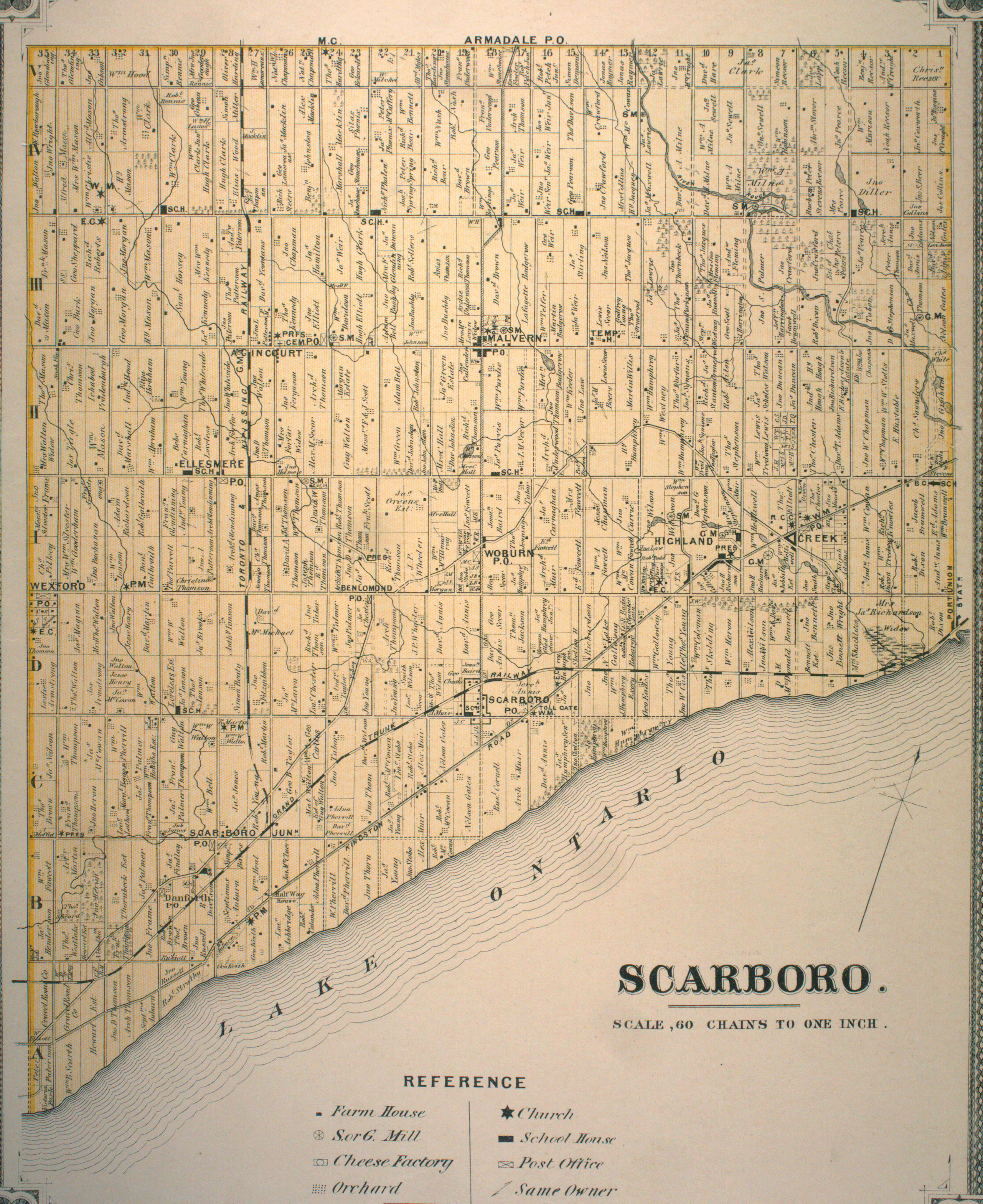
Map of Scarborough Township, c. 1916. Source: University of Toronto Map & Data Library.
Halfway House, Kingston Road & Midland Avenue, c. 1920. The building is currently situated at Black Creek Pioneer Village. Source: City of Toronto Archives.One notable landmark near Birchmount Road is not a rest stop but Scarborough Arts. The non-for-profit arts organization has a mandate “to create and cultivate innovative arts and cultural programs in Scarborough.” It’s a good one.
In addition to facilitating and promoting artistic programs, Scarborough Arts also has rotating exhibition space, appropriately named the Bluffs Gallery. In March 2016, its showcase was ‘YEARBOOK’, a brilliantly-conceived and -executed exhibit which utilized high school yearbooks to tell Scarborough’s history and its remarkable demographic change in particular.
It’s not a surprising discovery, but Scarborough didn’t begin to really diversify until around the 1980s. In addition to offering demographic snapshots, I enjoyed the cultural tidbits that could be gleaned from the yearbooks, such as what kind of school clubs existed and the advertisements of local businesses of the day.
Agincourt Collegiate Institute yearbook, 1964. I attended and graduated from the school some 50 years later.
The Scarborough Arts office is a little unconventional in that it is housed in a converted 1920s dwelling. Its ‘backyard’ is the Harrison Properties, which makes up part of the Waterfront Trail and whose name strikes me as having some sort of history perhaps relating to a previous owner of the lot. I’ve found nothing on the topic, however.
The park backs onto the Bluffs, although a fence and a warning blocks access to the ridge for safety reasons. More on that later.
Further up Kingston is the Rosetta McClain Gardens. The backstory of this gem is fortunately known and offered up in a couple of plaques. Rosetta McClain once owned this land, and upon her death, her husband and son gifted the lot to the City of Toronto for a public park. Interesting to me in the story is McClain’s father was in charge of the J & J Taylor Safe Works operation in Old Town.
The gardens are naturally a better a sight in the summer, but even in spr-winter the awe of the space is evident.
The frame of the old McClain house also still stands in the park as a monument…and as a backdrop for wedding shoots.
Access to the Bluffs themselves can be tricky and elusive. There are many’a sign on local streets south of Kingston which advise people to, well, go away. It reminds me of the ire of local Hollywood residents concerning tourists trying to get to the Hollywood sign.
Fortunately, there is a path beside Wynnview which leads down to Scarborough Heights Park. The bottom of the steep trail delivers a great view. The eye can follow the curve of the Scarborough coast as seen in maps as well the endless blue expanse of Lake Ontario.
This is easier going down than up.
Scarborough Heights Park, 1911. Source: City of Toronto Archives.
The way is long and muddy (and marked with bricks), but the reward at the end is worth-while.
These natural wonders are the leftovers of Glacial Lake Iroquois, whose geography is apparent throughout the city, most famously along the Davenport escarpment near Casa Loma. They are the same Bluffs that might exist in unknown narratives of Aboriginal settlement in this part of Scarborough. And they are the natural wonders Elizabeth “Don’t-Call-Me-Lady” Simcoe sailed past in 1793 which reminded her of her English home.
Of course, the elements and human activity have taken their toll on the Bluffs today, robbing them of stability and their chalky exterior in some places. I might argue their erosion is, though, a good – albeit, unfortunate – marker of time and a reminder of their history and pre-history.
Scarborough Bluffs, 1909. Source: City of Toronto Archives.
One thing that has remained consistent about the Bluffs is the marvel surrounding them. Sometimes it is hard to connect to bygone times and the psyches of people who lived within them, but human feeling and intelligence was no less primitive one hundred years ago than today. The people who explored Scarborough’s coast for an afternoon outing likely thought and felt the same as us when we do the same. That’s a comforting idea.
Scarborough Bluffs, 1915. Source: City of Toronto Archives.
The Bluffs of course stretch beyond Scarborough Heights for more stunning views, including across the way at Scarborough Bluffs Park. But that’s another day.
If all you knew about Bridlewood was the origin of its name (yes, it involves horses), that would be a great enough tidbit. Fortunately, the intrigue of this North Scarborough community reaches far beyond its curious moniker.
Let’s begin on Huntingwood Drive near Birchmount Road, for example, where a trio of stubby saintly- and stately-named roads, each progressively shorter than the other, dead end at the Tam O’Shanter Golf Course (related: you can read about my take on the club and area here). They might be some of Toronto’s shortest streets.
At the intersection, Huntingwood Square houses Chris Jerk and Hunter’s Pizza, great local eateries that showcase a few of the tastes of Bridlewood and Scarborough.
Bridlewood also hosts a portion of the North Scarborough Green Loop, a cycling and walking route that winds around the upper part of the borough.
From Huntingwood Drive, the loop turns onto the West Highland Creek trail, the main waterway through the area.
On its way towards Finch Avenue, the channelized creek splits off in two places, the latter of which leads into L’Amoreaux Park in one direction and follows the Loop in the other.
The Highland leaves the cycling path behind at L’Amoreaux Drive, and continues to its terminus at Brookmills. Nearby, on the Donway-esque Bridletowne Circle, there’s L’Amoreaux Collegiate Institute. Its grey 1973 exterior and coloured lockers were quite familiar to me in the 90s while attending Saturday Greek school.
A neat tidbit: Rush’s Subdivisions, the Willowdale group’s 1982 anthem about the alienation that goes with growing up in suburbia, was appropriately filmed at L’Am (albeit, I don’t know if that outsider feeling is exclusive to the suburbs).
When the mall was to be constructed the 1970s, the developer had this collection of 19th century gravestones at the end of a dead-end path to contend with.
Christie’s Methodist Cemetery, 1974. Source: Toronto Star Archives.
The trustees of the overgrown necropolis as well as the descendants of its “inhabitants” successfully fought against the desire to move the graves. And so it remained — a welcomed rural leftover within post-war Scarboro.
The cemetery has its origins as a part of Isabella Graeme and Isaac Christie‘s 200 acres on Concession IV lot 33. They donated a portion of their land in the 1840s to a congregation for a church. Their headstones, along with their relatives, are housed in the parkette. A plaque tells their story.
Like Christie’s Cemetery, the First Alliance Church and its parking lot hold another link to Scarborough’s rural past.
The church was built in 1977, but a photo in the Toronto Star five years prior shows a Mr. Harold Patton plowing his field in the presence of newly constructed hydro towers, townhouses, and apartment buildings. It’s a remarkable view of the borough in transition. Suburbia emerging.
Harold Patton on his farm near Warden & Finch, 1972. Source: Toronto Public Library/Toronto Star Archives.Finch & Warden, 1973. Source: City of Toronto Archives.
The hydro towers in the photo are gone, but the muddy corridor remains. There seems to be something happening with it.
North Bridlewood Park has an unexpectedly king-of-the-castle-esque hill. (At least, I hope local children use it as such. I could be out of touch. Let’s go with toboganning. That’s a thing still.)
Further south, Bridlewood Park has a similar, more popular hill. Good for flying kites.
The existence of a Bridlewood and a North Bridlewood is somewhat curious to me, given that the schools and parks aren’t actually that far apart. It might lie in how the community developed. The original Bridlewood subdivision is located between Sheppard Avenue and just north of Huntingwood and between Pharmacy and Warden Avenues. It was completed in 1966.
Bridlewood under construction, 1962. Source: City of Toronto Archives.
Later “expansions” north toward and past Finch, which we might call North Bridlewood today, came in the 1970s. They might also be considered part of the largerBridlewood neighbourhood (although, one could say there is overlap with L’Amoreaux and Tam O’Shanter — borders seem to be fluid). Judging by the friendly faces I speak to as I make my way down Bridlewood Boulevard, this is great area.
Lapping back to the Bridlewood name, the northeast corner of Pharmacy and Sheppard was once home to industrialist and distiller Harry Hatch‘s indoor horse racing track. Hatch took over the stable in 1926, adding “championship horse breeder” to his profile in the process.
Harry Hatch’s Indoor Racetrack, 1961. Source: City of Toronto Archives.
When the structure was demolished around 1963 to make way for the housing development, Robert McClintock, who had an unsuccessful go at developing Bridlewood Mall, harnessed its history in its branding.
Lately, I’ve been using the City of Toronto Archives’ collection of aerial photographs to supplement my blog posts. I think they are an excellent way to unpack a story and show the physical changes in Toronto’s built environment. I have become quite fond of the 1965 aerials in particular, because beyond how pivotal a year 1965 was for Toronto, the images themselves are very crisp and great to look at.
While the whole city is interesting to look at, the east end and Leslieville have a certain fascination to me in particular. In 1965, the area was still very much a factory town.
All photos courtesy of the City of Toronto Archives
LeslievillePort LandsConsumers Gas Station BCarlaw Avenue & Logan AvenueDunlop Tires (now the site of Jimmy Simpson Park) & Riverdale Station
The archives’ aerial photographs are also neat in that sometimes they include markings or writings on them. I’ve seen streets and buildings labelled, and also planned subdivisions and street extensions. The 1965 aerials take this a bit further in drawing out two possible routes of the Scarborough Expressway, which began planning in 1957 and was scrapped in 1974.
The route on the right was approved in 1968, but never built. I’m not sure if the left path was ever in serious consideration because while both involve serious neighbourhood destruction, the western route is much more dramatic in terms of expropriation.From Lake Shore & Leslie, the two routes curve on either side of the sewage treatment plant, west of Greenwood Racetrack.Both routes have parclos at Dundas. The western route runs over Ashdale and Craven (although much more than these streets would have suffered), while the eastern runs over the Small’s Pond (buried) and Creek east of CoxwellNorth of Upper & Lower Gerrards, the paths seemingly have mini-routes within them (this might be scribbles too). They converge at the CNR tracks.The routes parclo at Woodbine and run over the CNR right of way into Scarborough, meeting at Kingston Road and then the 401.
Other east end locales of note:
Greenwood ParkGreenwood Subway Yard, opened in 1965. Previously a brickyard and then a garbage dump.Monarch Park. The last brickyard along Greenwood Avenue closed here in the 1950s.Russell CarhouseSt. John’s Norway Cemetery
If one wants to learn about the roots of Scarborough, Thomson Memorial Park in Bendale is a pretty good place to start. After all, it is located on the historic property of the Thomson family – the first European settlers in Scarboro Township. Thomson Park also houses Scarborough Museum, which serves to tell the history of the Thomsons and the borough. More than that though, Bendale embodies and showcases the great layers of Scarborough: from its pre-contact period to rural pioneers to post-WWII multicultural suburbia.
Scarborough Museum, which offers pay-what-you-can admission, is a collection of structures: Cornell House, McCowan Log House, Hough Carriage Works, and the Kennedy Gallery. Together, they form a sort of scaled back version of Black Creek Pioneer Village.
After arriving in the township in the late 1700s, Scottish immigrants David and Mary (née Glendinning) Thomson followed an old aboriginal trail to a thickly wooded bush on the banks of the Highland Creek. Their task was tall: clear the property and make it inhabitable. In 1802, they patented 200 acres on lot 24 concession 1 (today’s the east side of Brimley at Lawrence). David’s brother, Andrew Thomson, patented 200 acres on the adjacent lot 23 to the east.
Although none of the museum buildings themselves were part of the Thomson property, they originate from different areas of Scarborough and belonged to noteworthy families in the township. The artefacts within the museum also mostly originate within Scarborough, including a few items belonging to the Thomsons.
Cornell House fronts Scarborough Museum, and was the museum’s first structure in 1962. Originally located at Markham and Ellesmere, it was built for Matilda and Charles Cornell in the 185os. The Cornell family sold the property in the 20th century to the Lye family. It was saved from demolition in 1961 and transported to Thomson Park. (One can imagine a building on wheels, meandering through Scarborough.)
A highlight of Cornell House is the wood and coal burning oven. A large part of Scarborough Museum’s programming is food preparation, and the oven plays a central role in that. (I enjoyed a delicious chocolate cookie during my visit.) For the Cornells, it also ingeniously heated the bedrooms above with wood during the day and coal at night.
The parlour room has an amazing collection of musical instruments. Unknown to me was Scarborough has very musical roots, apparently. It also speaks to the detail and amount of artefacts within the museum. There is something in every room that catches the eye and has a story.
If Cornell House represents a second generation house (that is, the kind of house the children of pioneers would aspire to build), McCowan Log House might be a first-gen home. It dates from the 1830s to a William Porteous McCowan of Malvern – the same McCowan for which the street is named. Much like Cornell House, it was rescued by the Scarborough Historical Society in the 1970s and added to the museum.
McCowan Log House is built primarily of wood and consists of a main cooking/living room (with a very hearty fireplace used for more historic cooking programs) and two bedrooms. McCowan lived in the home with his mother and sister, thus the two rooms. In terms of cabins, the house is actually spacious with additions McCowan undertook on the structure.
The crib in the foreground belonged to the Thomsons.
The Thomsons built their own log house out of pine and oak, too. When he wasn’t working his land, David was a mason in Scarboro and the Town of York. Mary’s tasks were concentrated in the house, but when David was absent, Scarborough historian Robert Bonis writes she was left “to face the dangers of the forest alone with her children”. He recounts how wolves would jump on the roof of their cabin and gnaw at the door. My favourite anecdote of his, though, is Mary boldly wielding an axe to scare off a bear trying to make off with a pig! A plaque honouring Rhoda Skinner and other pioneering women stands behind the main building. Skinner was the wife of William Cornell, father of Charles Cornell.
Hough Carriage Works is a recreation of the original Hough Carriage Works which stood at Birchmount and Eglinton. This establishment was responsible for building and repairing wagons and more. Interestingly, it also functioned as a gathering point because it served an entire community, so it allowed residents to conduct business with each other.
A penny-farthing, also known as a boneshaker for the toll it takes on a rider’s body.
Finally, the Kennedy Gallery is adaptive reuse at work. Formerly a 1920s garage from the Lyman Kennedy farm in Agincourt, it is now rotating exhibition space. On until March 2016 is a neat exhibit about Frances Tweedie Milne and her writings in the context of rights and the Magna Carta.
Facebook in the 19th century: “Killed 10 pigs today. Men cut them up, Margaret and I salted them. Tired now.”
Exiting Scarborough Museum, Thomson Park is very expansive. The Thomsons used the area as a gathering point before they gifted it to become a public park in 1962, so it enjoys that continuity. It hosts an exercise circuit and a number of seating pavilions, which come in great use at the annual Scarborough Ribfest. The west branch of Highland Creek also winds through the park.
Somewhat hidden within the history of Thomson Park is the former Canadian Northern Ontario Railway. I first encountered this now defunct railway at Taylor Creek Hydro Corridor. From East York, it passed northeast through Scarborough and the western edge of this park. By 1926 however, it was abandoned and the tracks were removed.
The Canadian Northern Ontario Railway roughly followed this path. An embankment is also still visible where it crossed Highland Creek.Thomson Memorial Park area, 1956. The Canadian Northern Ontario Railway right of way is still visible. Source: City of Toronto Archives.
St. Andrews Road sits atop a ridge as it slinks from Brimley down to McCowan, echoing the route of Highland Creek to its south. It’s definitely a throwback road. For the Thomsons, the road network in the 19th and early 20th centuries mostly consisted of the main roads that essentially formed property boundaries – except for St. Andrews which curiously shows up in early maps.
In 1818, David Thomson donated part of his land to a congregation started by his brother Andrew and others. The result was a 30 by 40 foot frame church that would become St. Andrew’s Presbyterian – the first church in Scarborough. The street serving the church was appropriately named “Church Lane”, now St. Andrews Road. What stands today is the second St. Andrew’s Church, built in 1849.
Historic St. Andrews Road also houses a number of other early landmarks such the 1896 Scarborough Centennial Library, and St. Andrews Cemetery, which is the resting spot for a who’s who of Scarborough pioneers. The oldest brick building in Scarborough, Springfield, the 1840 home of James A. Thomson is also found here.
Following the Gatineau Hydro Corridor back down through the park, I cut through Scarborough General Hospital to Lawrence Avenue. The hospital dates from 1952 with its distinctive circular tower coming in 1968. It’s the major landmark at McCowan and Lawrence today, but historically the honour might have gone to Bendale’s post office.
1878 Map of Scarboro Township. The 1878 community of Benlomond was renamed Bendale in 1881 to avoid confusion with a nearby town that already had the moniker. Source: Old Toronto Maps.
I don’t realize it at the time passing by it, but the subdivision north of Lawrence between McCowan and Bellamy features streets that all begin with “Ben”. Quirky? You bet.
The Ben Jungle subdivision dates from 1956.
Finally, Tabor/Taber Hill Park on Bellamy was the site of a 13th century Huron-Wendat ossuary. It was discovered in 1956 after the hill was set to be leveled to accommodate a new subdivision. Construction immediately stopped, excavations began, and at the end of it, the hill was preserved with a monument to the ancient burial mound. An excavated village on the north banks of Birkdale Ravine also connects to Tabor Hill. As I ascend the hill, there’s a family and their dog who had the same idea. They ask me to snap a portrait of them. I oblige.
The view from Tabor Hill is provocative. All around is suburbia. The faint outline of CN Tower is even visible from this perspective. But none of it was here 700 years ago. The next people to see Scarborough as the Wendats saw it were the Thomsons. But the Scarborough David and Mary left was different than the Wendats’ Scarborough and different still than 2016’s Scarborough. And yet, all three realities seem to converge in this one spot.
The White Shield Plaza hugs the northwest corner of Kennedy Road and Lawrence Avenue. Without any disrespect to the mall (which hosts Flipper’s and other tenants) though, my eye goes to two restaurants just off the strip mall.
On first look, Harry’s Drive-In looks of another era. And that’s because it is. Immediately I think of Johnny’s Hamburgers at Victoria Park and Sheppard. It’s a small shack of a burger joint that slightly compensates for its lack of space inside with a tiny patio outside. Even the name is to the point. No gimmicks. My observation is pretty bang on, too: it’s been here since the 1960s.
Beside Harry’s, there’s Nova Ristorante – a sitdown Pizza Nova restaurant. The first Pizza Nova. Sam Prumicci and his brothers opened the shop here in Scarborough in 1963. One thinks of the pizza chain as a takeout/delivery place, but restaurants have been part of its past and present.
The Hellenic Home for the Aged sits on the southeast corner of the intersection. Before the home however, there was a hydro station here.
Kennedy & Lawrence Hydro Station, 1960. Source: City of Toronto Archives.
Mike Myers Drive, which was (re)named for the Scarborough comedian in 2002, slinks behind the seniors home. I believe a few power stations still remain.
Kennedy Road looking north to Lawrence Avenue, 1960. Source: City of Toronto Archives.Kennedy Lawrence Hydro Station aerial, 1965. Note the spur off the Canadian National Railway. Source: City of Toronto Archives.
The houses on this stretch of Kennedy Road south of Lawrence date from the 1950s.
Down in the hydro field, there is (or was, rather) some planting a’happenin’. This is Givendale Allotment Garden, and its concept is new to me. My sense is it’s an unknown idea in general – “secret gardens”, as I’ve read. It’s certainly a neat use for a hydro fiend – much more advisable than model airplane or kite-flying.
If my understanding is right, one can apply for a permit to use a garden plot in one of 13 designated allotment gardens in the city. Applications are accepted the first day of February and permits are issued the first day of May.
Finally, Jack Goodlad Park is a nicely sized park with basketball courts, a recreation centre, playground, and a couple of baseball fields. Jack Goodlad, its namesake, was a Scarborough alderman.
The Pan Am Path also passes through Jack Goodlad Park in its meandering route through Toronto. It’s one of the legacies of the 2015 Pan Am & Parapan Am Games.
Before it was a park and trail though, Jack Goodlad Park was the Scarboro Drive-In. The theatre opened in 1952 and closed around the late 1970s when drive-in movies in Toronto declined in popularity. It’s fascinating to learn about because it tells us a bit about what Toronto suburbia used to look and be like.
Scarborough Council purchased the Scarboro Drive-In property and redeveloped it into a municipal park beginning in 1980. Goodlad himself had a big hand in the end of the movie theatre, objecting to the seedier movies that were playing in the supposedly family-friendly venue.
Scarboro Drive-In, 1960. Source: City of Toronto Archives.Scarboro Drive-In aerial, 1965. Source: City of Toronto Archives.
Kennedy Road between Finch and Linwood Avenues is, at first glance, an inconsequential stretch of street. 1km of nothing. A bit of digging, however, and there’s a story. There’s always a story.
Beginning at the top, there’s the Hugh Clark House. A rural leftover nestled in behind a gas station. The Clark family once lined the north side of Finch with their farms. The first of the Clarks to plant his roots was Hugh‘s father, William, who settled two lots over at Birchmount Road in 1838. I wrote a little bit about the elder Clark while exploring his property at today’s L’Amoreaux Park.
Crossing the street, one comes to an innocent looking parkette. Today’s park, however, is yesterday’s street jog. Kennedy at one time jogged left at Finch, forcing a northbound traveler to turn left and then right before continuing north. At some point Kennedy was reconfigured to run seamlessly through the intersection. An orphaned section of the old route remained south of Finch, however. The old Kennedy bus used to turn around at the loop when the bus route terminated at Finch. The triangular jog was eliminated for good in 1979, leaving us Kennedy Road Parkette.
Next, Lynnwood Heights on Southlawn Drive has been around since 1956. The school’s TDSB webpage notes an original population of 400, a staggering far cry from the current enrollment of 160 pupils. The surrounding subdivision also dates from around 1956, making it one of the older post-war developments in northern Scarborough. One can imagine as the area continued to grow, more schools opened to relieve Lynnwood.
Huntingwood Drive is an east-west alternative to Sheppard and Finch (at least, between Victoria Park and McCowan), but its existence is a relatively recent thing – around 1967, more specifically. It’s odd in the way it snakes close to Sheppard in some parts and close in Finch in others.
Kennedy Road & Area, 1965. Source: City of Toronto Archives. The future Huntingwood Drive is pencilled in bottom left. Finch jog at top.
Bookending the kilometre stretch is another farmhouse, Elmridge. This was the Pat(t)erson family homestead. Or, at least, one of them. Like the Clarks, the Patersons were a pioneering Scarboro family who toiled the land on the east side of the street between Sheppard and Finch. Robert Bonis writes in A History of Scarboroughthat a Thomas Paterson arrived here in 1820 from Scotland, clearing the land with his son. His descendants continued his work at Elmridge, eventually making the Paterson name synonymous with Agincourt. This excellently researched WikiTree entry breaks down the life of Thomas Archibald Paterson, the great-grandson of the original Thomas Paterson.
Consider this a sequel. Or, maybe a prequel. Whatever the case, if Wishing Well Acres is the Sullivan in Tam O’Shanter-Sullivan, here’s the Tam O’Shanter part.
We begin at Agincourt Mall. The shopping centre dates back to 1966, likely making it the third enclosed mall in Scarborough after 1954’s Eglinton Square and Golden Mile (Cedarbrae Mall predates Agincourt by four years but didn’t get its ceiling until 1972). The mall’s anchors are Wal-Mart and No Frills, but I can recall a time – in 1994, specifically – when they were Woolco and Loblaws, respectively. Walmart bought Woolco that year. No Frills came in the 2000s.
As much as malls like Agincourt are seen as shabby and sad (Agincourt Mall as of 2016 has a number of empty tenants), I’ve found that they are still appreciated locales. A lot of nostalgia fills their walls. The comments in this BlogTO article about Agincourt Mall by Robyn Urback prove that. Everyone has a story, or a store they enjoyed frequently, or an odd memory about something that isn’t there anymore. Mine is the RadioShack that was there in 1990s and 00s, reminding me of lost Canadian retailers. There is a Source in the mall now, but not in the same space as its predecessor.
Agincourt Mall was built on the Kennedy farm, with the farmhouse once located just north of the mall and south of the West Highland Creek. A walk down the street named for the family leads to a trail that lines the creek.
The path is sandwiched between an apartment and townhouse complex on one side and the creek and Tam O’Shanter Golf Club on the other. A look down at the shallow waterway produces a shiny sheet of ice over the surface and the occasional group of ducks in the non-frozen bits. But there’s also something that doesn’t quite belong.
Several pillars jut out on either side of the creek – two on one side and two opposite them. I count three sets of these abutments along the way. Their meaning isn’t hard to figure out: 3 sets of abutments, 3 phantom bridges. There is one question, though: what’s the story?
The answer: In the 1930s to the 1970s, this was the site of the Tam O’Shanter Golf and Country Club, the precursor to Tam O’Shanter Golf Course.
In addition to golf, the Tam O’Shanter Country Club complex had swimming, ice hockey, and curling. In 1971, the club erupted in flames, destroying some of the complex. In researching the fire, I’ve read many stories about people seeing the flames from afar. Like Agincourt Mall, the country club meant something to many people.
In 1973, the Province of Ontario, Metro Toronto, and Scarborough jointly acquired Tam O’Shanter and converted it into a municipal golf course. In the coming years, the complex would be gradually demolished and a new clubhouse would be built around 1980. Today, a couple of apartment towers on Bonis Avenue stand in the club’s former location.
Tam O’Shanter & West Highland Creek, 1967, Source: City of Toronto Archives.
Back to the abandoned abutments, the creek was located just behind the clubhouse and its bridges led to and from the golf course. Shortly after the course’s acquisition, the bridges were removed, presumably because the course layout would be reorganized.
But the creek hasn’t always run the same course.
Tam O’Shanter & West Highland Creek, 1956, Source: City of Toronto Archives.
The West Highland at one time swung north up into the golf course before dropping back down and resuming in a northwest direction. Around 1967, the creek was straightened and bridges were installed. The orphan bend remained as a sort of oxbox for some time, but since has been mostly filled in. One can still see the imprint of the bend today, though, notably through the pond and the ‘etched’ curved outline north of it.
Tam O’Shanter & West Highland Creek, 2015. Source: Toronto Historic Maps.
There is one remaining bridge, however – a wider, sturdier construction. There is a gate in the fence on the other side, so one can guess that at least it might have been a vehicular corridor. As of 2015, though, both ends have been barricaded to prevent any sort of use.
As the West Highland continues into the golf course and beyond, the trail comes to Ron Watson Park, renamed from Tam O’Shanter Park in 2005 in recognition of the long-time Scarborough resident, trustee, and councillor. Watson was honoured with a star on Scarborough’s Walk of Fame in 2011. The park forms the field of Tam O’Shanter School, featuring a nice playground…and a stone turret.
This viney tower became an instant curiosity to me. It looked old and misplaced. No doors (although, perhaps a sealed opening), a couple of ‘windows’ near the top. What was/is it?
I had to do some digging. Google presented nothing, so I consulted some aerial photos to try and date it. It’s been around since at least 1947, the first year on record for aerials in the Toronto Archives.
Charles Watson Farm, 1965. Source: City of Toronto Archives.Ron Watson Park, 2015. Source: Toronto Historic Maps.
So, Horsey sold his farm to Watson, who likely built the silo. When Watson’s farm was subdivided, the tower was never torn down with it. My guess is the task proved too difficult. It doesn’t fully answer the ‘when?’ part, but mystery solved!
Leaving the park and silo, the two-in-one Stephen Leacock Collegiate/John Buchan Senior Public School has had a place on Birchmount Road since 1970. It is built in the Brutalist (or, Heroic) style that was indicative of Toronto architecture in the 1950s to 1970s. The schools’ namesakes were a Canadian author and humourist and Scottish author and historian, respectively.
And while I’m profiling, Tam O’Shanter is a Robbie Burns poem. Another Scottish connection. The Anglo-Saxon roots and references of the Tam O’Shanter community is interesting though, considering what it became. Today, it is one of the more diverse areas in the city of Toronto.
Next, a derelict structure stands across the school. I don’t know its full context, but it’s most definitely another rural leftover.
On Bonis Avenue, there’s Agincourt Library and another great turret. Although the building opened in 1991, the library itself dates back to 1918. Within that time it has moved locales a few times, including a stay in Agincourt Mall. The branh carries three copies of A History of Scaborough. Its editor is a Mr. Robert Bonis, who lends his name to the street.
Down at Birchmount and Sheppard, a strip mall has gone through a makeover in the last few years. It’s about to get a new tenant, too: Starbucks. The sight is initial shock for me, if only because it’s strange to see one in this neighbourhood. My mind shoots to the old idea that a Starbucks is tell tale sign of gentrification, but I question whether it applies here. We’ll have to see.
Foregoing a stroll down Sheppard, I backtrack to Bay Mills Boulevard. The curved street offers a sort of ‘backstage’ view of Tam O’Shanter, showing off the apartments, church, school, field, playground that all front Sheppard. The intersection of Bay Mills and Sheppard is the start of the Sheppard Avenue East Avenue Study zone. On one side there’s another strip mall; on the other, a car dealership. They’ll surely be part of the plans.
Warden Avenue is further down the way, but that adventure lies in the mentioned Wish Well exploration. For now, that’s a wrap on this one.
If you have memories of Agincourt Mall, Tam O’Shanter Country Club, Stephen Leacock School, or Tam-O’Shanter-Sullivan in general, I would like to hear about it. Leave a comment below or tweet me!
Scenes From Toronto
Explorations into the history and geography of Toronto


![Half-Way House, Kingston Road. - [1920?]](https://i0.wp.com/scenesto.com/wp-content/uploads/2016/04/kingston-road-halfway-house-1920.jpg?ssl=1)


