A&P is part of Toronto’s retail history, especially so because the franchise does not exist anymore in the city.
In the 1950s, the American-based company, formally called the Great Atlantic & Pacific Tea Co., opened several new super markets in Toronto’s outer communities. These stores and their eventful inaugurations offer a lens into not only the history of the brand, but also the emergence and evolution of Toronto’s inner suburbs.
5559 Dundas Street West, Etobicoke
Toronto Daily Star, July 5, 1952. Source: Toronto Star Archives
The A&P at 5559 Dundas Street West at Brown’s Line opened on July 8, 1952. As the advertisement notes, it opened at the junction of two highways: Five (Dundas) and Twenty-Seven (Brown’s Line). It also backed onto a Canadian Pacific rail line. At the time of its opening, the intersection was sparsely populated. The larger community at the western edge of the Toronto area was Eatonville, best known for being the farming property of its namesake family and department store barons, the Eatons.
1953 Aerial Image of 5559 Dundas Street West Source: City of Toronto Archives
Very much in line with other store inaugurations in the period, the A&P advertisement presented the event as a multi-day spectacle. It was broadcasted over radio, with American singer and radio personality Smilin’ Jack Smith hosting. The famed 48th Highlanders band also played. The opening day flyer touts the supermarket as a “Parking Heaven” with plenty free parking. A map also boasted that “all roads” led to the supermarket, noting all the local major roads and the connecting communities. Many cars and people are depicted, including a long line filing towards and into the large glass store entrance. Altogether, it is very optimistic, with new life and new development now existing outside Toronto’s historic busy core.
The Globe and Mail reported the new super market cost $1,000,000 and included a warehouse building and a rail siding. It wrote: “The huge one-story structure provides consumers with the ultimate in shopping conveniences and affords the company the latest facilities for the efficient distribution of groceries in Ontario.”
By the end of the decade, the area had transformed along with the new store. Brown’s Line and Highway 27 were absorbed by the new Highway 427. The new interchange with Dundas resembled a cloverleaf. This development may have inspired the naming of the adjacent Cloverdale Mall directly across from A&P in 1956, an open air shopping centre whose anchor was another super market, Dominion.
1965 Aerial Image of 5559 Dundas Street West Source: City of Toronto Archives
Since 1952, the Dundas Street A&P has undergone a few noted changes. First, it is now Food Basics, which was founded in 1995 as a discount super market subsidiary under the A&P brand. Second, the complex’s area expanded, including an office space. This office is the Metro Ontario Division headquarters. Metro, a Quebec super market chain, acquired A&P Canada in 2005. Interestingly, at the Cloverdale Mall across the street, Dominion was acquired by A&P in the 1980s; the store is now a Metro.
Food Basics, 5559 Dundas Street West, 2021. Source: Google Maps
2022 Aerial Image of 5559 Dundas Street West Source: Google Maps
25 Glen Watford Drive, Scarborough
Toronto Daily Star, March 20, 1957. Source: Toronto Star Archives
The A&P at 25 Glen Watford Drive at Sheppard Avenue opened on March 21, 1957. It served the historic village of Agincourt, a community with roots in the 19th century whose nexus was the crossroads of Church Street (Midland Avenue) and Lansing Road (Sheppard Avenue). First Street, depicted in the advertisement’s map, was part of an Edwardian residential subdivision. In the 1950s, the community opened its earliest post-war subdivision east of the Agincourt High School. In 1959, bus service ran from Kennedy Road to Sheppard Avenue, looping at Glen Watford, Rural Avenue, and Midland; it was one of the first to serve northern Scarborough.
Like the Dundas Street store, the store opening was a week-long affair. It featured giveaways to shoppers, and a radio broadcast, featuring Scarborough Board of Health Officer and Agincourt resident, C.D. Farquharson. Free parking and parcel pickups were emphasized. Nearly thirty stores in Toronto and area were listed, some with details such as having air conditioning.
1957 Aerial Image of 25 Glen Watford Drive and Sheppard Avenue East Source: City of Toronto Archives
The evolution of the area around 25 Glen Watford contains some interesting developments. By the 1960s, Lansing Road became Sheppard Avenue; and Church Street merged with Midland Avenue to the south. First Avenue also became Agincourt Avenue. In 1963, the CP crossing on Sheppard was replaced by a rail overpass; the tracks were temporarily rerouted north during construction. Sheppard Avenue was also widened and Glen Watford was rerouted to curve towards Sheppard.
1963 Aerial Image of 25 Glen Watford Drive and Sheppard Avenue East. Source: City of Toronto Archives
In the late 1970s, the Glen Watford A&P was torn down. In its place, a strip mall was erected. A larger building also went up to the south, taking up space formerly occupied by properties on the north side of Sheppard removed in the improvements along the street the decade prior. This latter building was a roller rink called Roller World.
1963 Aerial Image of 25 Glen Watford Drive and Sheppard Avenue East. Source: City of Toronto Archives
In the mid-1980s, the area experienced its greatest evolution. In 1984, Hong Kong born developers bought the roller rink and transformed it into the Dragon Centre, an indoor Chinese mall (the former rink became a circular walkway for shoppers). It was the first of its kind in Toronto and Canada. The development spurred a change in Agincourt and Scarborough’s demographics, bringing East Asian residents and businesses to the area, including the strip mall to the north which replaced the A&P and the Glen Watford Plaza across the street, today’s Dynasty Centre.
The Dragon Centre wasn’t without controversy in the early years, however. Residents complained about the planning of the mall, particularly the parking and gridlock. There were also racist, xenophobic sentiments. Still, the mall endured, becoming a fixture in Agincourt.
25 Glen Watford Drive, 2021. Source: Google Maps
Today, the East Asian nexus on Glen Watford is set to endure another change. A development proposal has two condominium buildings to be erected on the site. A project entitled “Dragon Centre Stories” exists to preserve the memory of the places set to be replaced.
2022 Aerial Image of 25 Glen Watford Drive and Sheppard Avenue East. Source: City of Toronto Archives
2939 Dufferin Street, North York
Toronto Daily Star, March 10, 1958. Source: Toronto Star Archives
The A&P at 2939 Dufferin Street south of Lawrence Avenue opened on March 11, 1958. After WWII, Dufferin north of Eglinton Avenue filled out as an arterial street with commercial and industrial uses, and its surrounding residential streets with bungalows, schools, and churches. The Dufferin Street A&P backed onto Barker Stream, a tributary of Castle Frank Brook.
1959 Aerial Image of 2939 Dufferin Street Source: City of Toronto Archives
Like the other A&P stores, the opening of the Dufferin store featured contests and giveaways, including “free Cokes for everyone!” It also praised its car-friendly qualities: a giant parking lot, parcel pickup, and “all roads in North West Toronto” led to it. This automobile haven was in the immediately geography too; directly next to the A&P was a drive-in ice cream spot, Tastee Freez. An archival image of the Dufferin A&P offers a comparison with the image in the 1958 ad; the stores are very similar with a noted difference being the positioning of the logo’d tower.
A&P Supermarket, 2939 Dufferin Street, 1950s or 60s. Source: City of Toronto Archives.
Tastee Freeze, 2957 Dufferin Street at Glenbrook Avenue, northeast corner, 1950s or 60s Source: City of Toronto Archives
Today, the A&P store is a Lady York Foods, an Italian grocery store. A Dairy Queen is now on the same lot as the former The Tastee Freez. The transformation to Lady York Foods is particularly intriguing because it represents the general shift in demographics in the Dufferin-Lawrence area: The community is largely Italian-speaking.
2939 Dufferin Street, 2021. Source: Google Maps
Aerial Image of 2939 Dufferin Street, 2022 Source: Google Maps
Do you remember these three A&P super markets or any other early A&P stores? Leave a comment below!
Riverdale Avenue is located in the namesake neighbourhood of Riverdale, an area in the east end of the old city of Toronto. Found a short distance north of Gerrard Street East, the street runs about a kilometre between Broadview Avenue and Kiswick Street (between Pape Avenue and Jones Street). Riverdale Avenue is layered in its development with lost and gained extensions, buried waterways, and disappearing transit lines.
Riverdale Avenue, 2022. Source: Google Maps.
Origins
Riverdale Avenue was historically located on lot 14, a 200-acre parcel granted by John Graves Simcoe to John Cox in 1796. It was situated roughly between Broadview Avenue to just west of Logan Avenue, south of Danforth Avenue to the lake. The John Cox cottage, built before 1807 and currently the oldest home in Toronto still used as a residence, sits on the property.
1851 JO Browne Map of the Township of York Source: Old Toronto Maps
By 1815, the lot passed on to William Smith, which was then subdivided to his heirs in 1839. The 1860 Tremaine’s Map shows the property attributed to Thomas S. Smith. By 1878, the Illustrated Atlas of York County shows the property was divided further: the bottom two-thirds went to B. Langley (possibly for the namesake street currently on the street) and a road with smaller lots. The atlas shows the community around the lots was Don Mount and a post office was located at today’s Queen and Broadview.
1860 Tremaine’s Map Source: Old Toronto Maps
1878 Illustrated Atlas of York County Source: Old Toronto Maps
In the 1884 Goad’s Map, the street in 1878 had a name: Smith. It is also labelled as Plan 373. The street stopped at the lot line, roughly two thirds to Logan Avenue. Also in 1884, Don Mount, now going by Riverside, and the lands east to Greenwood Avenue were annexed by the City of Toronto.
1884 Goad’s Map Source: Goad’s Toronto
By the 1890s, Smith Street was extended into Lot 13. Between Logan Avenue and Carlaw Avenue, only the north side of the street was built as the south side constituted part of the William Harris Estate. The property also had a part of Holly Brook, also known as Heward Creek, running through it, which may or may not have impacted its later development.
1889 Plan of the City of Toronto, proposed intercepting sewers and outfall. Smith Street appears built east of Carlaw despite it not existing until the 1920s. Source: Don River Historical Mapping Project
Smith was also interrupted at Carlaw by another section of the Harris Property. A house now with a street address of 450 Pape Avenue was built on the lot in 1902, now known as the William Harris/Cranfield House. On the other end of the property at Pape, Smith Street continued in a separate section until MacDonald Street, now Kiswick Street.
1890s Map of Toronto and Suburbs East of Don Source: City of Toronto Archives
William Harris Home, 1973. Source: Toronto Public Library
The Lost Riverdale Avenue
In August 1887, the Board of Works recommended the opening of new street, free of cost to the city opposite Smith Street on the other side of Broadview Avenue; this was the first Riverdale Avenue.
The new street was proposed to run “…from Broadview Avenue to a connection with a street leading westerly through Riverdale Park to a new 50 feet street on the east side of the new line of the Don River, giving a connection with Winchester street at the bridge…”. In September, the motion to open the street was passed. It was surveyed with lots and appeared on maps in the 1880s and 90s. The 1895 City of Toronto Directory shows “a lane”, possibly referring to Riverdale Avenue, listed under 380 Broadview Avenue. The address also hosted six residents, Riverside Park (seemingly used interchangibly with Riverdale Park), Isolation Hospital, and Vacant Lots.
1893 Goad’s Map Source: Goad’s Toronto
In 1903, a by-law was inexplicably passed to close the street. Interestingly, in April 1904, Riverdale residents complained “bitterly of the odors” in Riverdale Park from the burning of garbage in the park’s dump “on the extension of Smith Street”. It is unclear if this was Riverdale Avenue, but the street did not appear on maps for much longer after 1903. Riverdale Park was a garbage dump from around the turn on the century to the 1920s; green pipes found today on the property are exhaust tubes for methane.
1902 Sankey Map Source: Old Toronto Maps
A New Riverdale Avenue
In the first decade of the 1900s, ‘Riverdale’ came into common use to refer to the neighbourhood. Riverdale Park itself was used since the late 1870s and the park was officially opened 1880, so the neighbourhood was seemingly named after the park, rather than the more obvious reverse. In 1905, Smith Street from Broadview Avenue to Carlaw Avenue was renamed to Riverdale Avenue, taking over the name of the closed street it was once connected to. East of Pape, the road was still Smith Street. A confused rider of the streetcar on Broadview wrote to The Star in 1906 asking about the renaming as some trolley drivers still referred to the street as Smith, while other drivers used the new name. The newspaper set the record straight: west of the intervening Harris property, the street was Riverdale; east of it was Smith Street.
1909 Map of Township of York and City of Toronto Source: Toronto Public Library
By 1913, the south side of Riverdale between Logan and Pape, part of the Harris Estate, was subdivided under plan 445E. The move allowed for the extensions of Langley Avenue, Victor Avenue, and Simpson Avenue across to Carlaw. The circumstances surrounding this development are unclear, but the branch of Heward Creek/Holly Brook which ran diagonally through the lot stopped appearing on Toronto maps around this time according to Lost Rivers Toronto. Leslieville Creek, which ran through Smith Street, was also potentially buried in the 1910s.
1909 Topographical Map of the Toronto Region Source: McMaster University
1912 Map of Toronto. Source: University of Toronto Map and Data Library
1913 Goad’s Toronto Source: Goad’s Toronto
In 1922, Riverdale Avenue was finally extended into the remaining Harris Estate east of Carlaw. The property was subdivided into lots under Plan 587E; some of it became the yard for Pape Avenue School. It was also one of the few remaining tracts left in Riverdale as most of the district by then had been subdivided and redeveloped. Growth in North Riverdale was aided by the opening of The Prince Edward Viaduct in 1918.
1924 Goad’s Map Source: Goad’s Toronto
The extension was instrumental in Toronto’s transit expansion: it provided a key east-west link for a streetcar line on Pape and Carlaw in an growing, under-served part of the city. Langley Avenue was considered in the role in during World War I, but the idea was rejected by residents as it passed by the school; it even got as far as putting up trolley poles before the plan was nixed. The Globe reported in December 1922 that even with the line, development had yet to come to street. Even though water and sewer lines were passed on the street, there were no sidewalks and only pavement for the tracks. In effect, the corridor was a streetcar right of way. This sparse development would be rectified in short time as the 1924 Goad’s Map shows a very built-on Riverdale Avenue.
1922 Toronto Civic Car No. 78 on Pape Avenue at Bain Avenue Source: City of Toronto Archives
1922 Pape Avenue at Riverdale widening Source: City of Toronto Archives
1924 Toronto Transit Commission Map Source: University of Toronto Map and Data Library
1924 Goad’s Map Source: Goad’s Toronto
The tram line was eventually absorbed into the Harbord car and followed a winding route through Toronto’s west, central, and east areas. The line closed in 1966 and its tracks were removed. Finally, Riverdale Avenue was completed with the disconnected section of Smith Street from Pape to Kiswick being absorbed by and renamed to Riverdale around 1926. Ahead of its renaming, The Daily Star provided some funny commentary.
Toronto Daily Star, April 28, 1924. Source: Toronto Star Archives
1925 Lloyd’s map of Greater Toronto and suburbs Source: York University Archives
The Three Riverdale Avenues
Today, Riverdale Avenue can be thought of in three sections based on their histories and geographies: Broadview-Carlaw, Carlaw-Pape, and Pape-Kiswick. Each have distinct visual differences and vibes which point to their layered development.
The western and oldest part of the street between Broadview and Carlaw is narrow, accommodating only eastbound, local traffic. Trees hang over the road in several spots making for a quaint stroll. It boasts houses mostly dating from the 1880s to the 1910s with oldest homes located on its north side near Broadview — the old Lot 14 — including two heritage homes: 1885 William Jefferies House and 1890-91 John Vick House. The south side between Logan and Carlaw as the ‘youngest’ with mostly 1910s constructions.
Riverdale Avenue, east of Broadview Avenue, 2021. Source: Google Maps
William Jefferies House, 2019. Source: Google Maps
Riverdale between Carlaw and Pape makes up the avenue’s ‘newest’ and busiest section. The houses lining the street are semi-detached bungalows built in the 1920s. Whereas Broadview-Carlaw is a local road, this central section is more of a through street with four lanes at its widest to accommodate parking, heavier traffic, and public transit, such as the Pape bus and its predecessor Harbord streetcar. Travellers coming from Broadview or Logan might note how Riverdale ‘opens up’ at Carlaw with its larger road surface and fewer trees. They would also see how this middle section is slightly misaligned with the rest of the avenue because of its width.
Riverdale Avenue, east of Carlaw Avenue, 2019. Source: Google Maps
Finally, from Pape to Kiswick, the street mixes the qualities of the other two sections. It offers two-way traffic like the Carlaw-Pape section to the west, but is narrow like Broadview to Carlaw. The residences themselves are mostly Edwardian detached and semi-detached homes from the 1910s and 1920s, offering a middle ground in age in the three sections.
Riverdale Avenue, west of Pape Avenue, 2021. Source: Google Maps
Note: This article is the second piece in a two-part series.The first can be found here.
In the 1960s, Toronto had a big question to address: “What would replace the commercial section across The New City Hall?” What followed was action to remove the Queen Street shops between Bay and York Streets and replace them with a complementary project worthy of the new civic centre.
The Expropriation Question
As Toronto entered the 1960s, progress on the Queen Street question seemed slow. In October 1960, there were reports that demolition would begin in the autumn of 1961 or spring of 1962 on the “seedy” south side. The Planning Board was preparing an invitation to attract private developers to redo the site. However, in May 1962, this draft invitation was presented to city council for approval. City Council now had the estimate down to $6,250,000 to buy the properties, but the The Globe and Mail anticipated difficult negotiations with property owners, particularly with the Municipal Hotel and Casino Theatre, who where the largest land owners on the block. The city approved a motion to start expropriating properties, but it was unclear whether this was a path to be taken.
Queen Street West, 1963. Source: City of Toronto Archives
“The Commercial Slum Across City Hall”, 1964. Source: Toronto Star Archives.
For the Municipal Hotel, owner Arthur Mintz was not going along with city plans to redevelop his property. He had his own project: a three million dollar, 14-storey office tower to replace the hotel. Mintz’ hotel was key in building an office tower at Queen and Bay, but the owner was not going to sell at even a reasonable price to a developer, instead opting to go at it alone. A by-law was passed indicating that whatever new development went through on Queen, the ends of the strip would have towers while the middle would be lower so not to “spoil the view” of the new city hall. The holdup? Owners of these central lots were unwilling to sell. The Daily Star’s editorial section and others advocated for expropriation.
“The Commercial Slum Across City Hall”, 1964. Source: Toronto Star Archives.
Redevelopment
On August 12, 1964, Toronto City Council voted 17-4 to expropriate most of the block bounded by Queen, Richmond, Bay, and York Streets. Mayor Phillip Givens, a pro-development politician, was a large proponent of the expropriation option and the redevelopment of Queen Street as a whole. It was the first time in Toronto history in which the city opted to expropriate land to sell to private interests rather than execute a public project. Development Commissioner Walter Manthorpe warned that renewal was still another 10 years away with steps needing to be taken to take seek Ontario Municipal Board approval for the expropriation, take possession of the properties, demolish them, sell to developers, and come up with a redevelopment plan for the province’s approval. Proposals started to come in which would the potential form the site and Queen Street in general would take, including an interesting plan which would see a tunnel under Queen and the surface turned into a pedestrian mall between Yonge and University.
Controller Herbert Orliffe’s Plan for Queen Street, 1964. Source: Toronto Star Archives
1964 South side of Queen Street West. Union Hotel at 71-73 Queen St. W., the Broadway Theatre at 75, Harry’s Men’s Shop at 79, the Frankel Building at 81, the Toronto Labour Book Store at 81A. Lawrence Credit Jewellers at 83, the Lantern Cafe at 85, and the Festival Cinema at 87-95. The Festival was known as the Casino and the Civic Square Theatre. Source: City of Toronto Archives
Queen Street Redevelopment Plan, 1964. Source: Toronto Star Archives
Much like the civic centre on the north side of Queen, the city decided to hold a design competition for the block leftover by the soon-to-be expropriated and demolished shops. The eastern end of the block would not be part of the project. In November 1964, Mintz sold the Municipal Hotel to a private developer, Reuben Dennis. The other properties included the Victory Building on Richmond St., the Temple and Dominion Bank Buildings on Bay St., and the Hamilton Trust property on Queen Street, the latter of which suffered a fire in 1963 and which Dennis also bought.
Givens’ View Across Queen Street, 1965. Source: Toronto Star Archives
69-73 Queen Street West, 1965. A vacant building and the east side of the Union House. The Victory Building on Richmond Street West is visible behind the empty Queen Street West demolition site. Source: City of Toronto Archives
On September 13, 1965, the new City Hall and Nathan Phillips Square was revealed to Torontonians. The winning space-aged design by Finnish architect Viljo Revell consisted of two curved towers of differing heights, a central ‘oyster’ housing the council chamber, and a large open space with a wading pool, arches, public art, and a podium.
79-83 Queen Street West, showing Harry’s Men’s Shop and Vanguard Bookstore in the Frankel Building, and Lawrence Credit Jewellers on the west side of the Broadway Theatre, 1965. Source: City of Toronto Archives99-109 Queen Street West, showing Downtown Resales, Richmond’s Trading Post, Barney’s Furniture Resales, S. Simonsky Ltd., and Showbar Good Food, 1965. Source: City of Toronto Archives
105-115 Queen Street West, showing Barney’s Furniture Resales, S. Simonsky Ltd. (vacant), Showbar Good Food, Toronto Trading Mart, Henry & Co. Jewellers, and vacant commercial space, 1965. Source: City of Toronto Archives
South side of Queen Street, 1965. 1. 40-foot-high bank building at Bay and Queen Sts; 2. An office building of 29 to 31 storeys at Bay and Richmond. 3. Next to the bank another office of 21 to 23 floors. 4. An arcade no more than 10 storeys tall containing night-clubs restaurants and shops. 5. 35-storey convention hotel. Source: Toronto Public Library
Across the street, there were some empty storefronts and vacant lots. For the shops that remained, there were ‘expropriation sale’ signs. By the next year, most of the block was razed to the ground and replaced by a level surface of sod and sidewalk.
Queen Street Demolition, 1965. Source: Globe and Mail Archives
Queen Street West site, 1968. Source: Toronto Public Library.
Aerial image of Queen Street West, 1969. Source: City of Toronto Archives
In 1968, a mini-saga began in who would receive the rights to redevelop the property, which council was to rent out to the winning developer for 99 years. In April 1968, City Council approved a proposal which would see Third Generation Realty Limited build a $50-million hotel-convention centre on the three-and-a-half acre property. However, the Finance Commissioner determined Third Generation did not have the financial proof to back its proposal. In July, Council voted again, this time approving a $34-million scheme by Inn on the Park-Four Seasons, the other bidder in the April vote. During the event, an alderman was even accused of accepting a bribe, which he denied. In 1969, construction began on the 43-storey, 1,400-room hotel, which would become the Four Seasons-Sheraton Hotel. John B. Parkin Associates, who worked on City Hall, designed the complex.
Four Seasons Hotel Construction, 1969. Source: Globe and Mail Archives.
Excavation for Sheraton Centre, Queen west of Bay looking south, 1972. Source: City of Toronto Archives
Site of the Sheraton Four Seasons, 1970s. Source: Toronto Public Library.
Welcome to the Sheraton-Four Seasons Hotel
In 1972, the Sheraton-Four Seasons Hotel opened (the ‘Four Seasons’ would be dropped in 1976 as the hotel pulled out of the venture), the culmination of a 15-year saga to renew the Queen Street West strip across Toronto’s new municipal hub. Carrying the memorable street address ‘123 Queen West’, it was the second largest hotel in Toronto at the time of opening behind only the iconic Royal York Hotel (it was surpassed by the Chelsea Delta which opened only a few years later).
Four Season Sheraton Hotel Opening, 1972. Source: Toronto Star Archives
Conforming with the by-law from a decade earlier, the main hotel tower is situated off to the side of the city hall and square towards York Street, offering an unobstructed vista. The eastern side of the block saw the erection of a two-storey TD bank branch and the Queen-Bay Centre, consisting of the 25-storey Thomson Building and the Munich Re Centre, opening in 1972 and 1973 respectively. The latter building opened on the site of the demolished Temple Building, whose fragments are found at the Guild Inn Park.
In 2022, at fifty years old, the Sheraton Centre is a unique modernist, Brutalist construction. Its central area forms an atrium of waterfall gardens designed by J. Austin Floyd, the famed landscape architect who also left his footprint at the famed yet now lost Inn on the Park hotel at Leslie Street and Eglinton Avenue.
View of south side of Queen Street West from Bay Street, 1983. Source: City of Toronto Archives.
On the Queen Street mega-hotel, architect Michael McLelland wrote how “metropolitan structures like the Sheraton Centre are an integral part of the downtown morphology”. Its views of the complex across the street, which was the catalyst of its construction, are unparalleled in Toronto.
View from the Thomson Building, 1981. Source: Toronto Public Library
The Sheraton Centre and Toronto City Hall are fine examples of Toronto as a city made and re-made. They mark the ‘creative destruction’ of the post-war years. The south side of Queen Street between Bay and York was an interesting mix of establishments, many with varying stories and origins. The condemning of the strip as a ‘commercial slum’ and its subsequent replacement offers a complicated takeaway. On the one hand, the physical erasure has understandably hidden those histories from collective consciousness; on the other, the emergence of the Sheraton Centre has offered Toronto a marvel in itself. For better or worse, Toronto was growing up after World War II — in area, age, building heights, and architectural styles. The construction of the Sheraton Centre was in itself a microcosm of this period of transformation — and the representative of the expendability of centrally-located, culturally- and socially-colourful sectors like this one.
Note: This article is the first piece in a two-part series. The second article can be found here.
When Toronto’s New City Hall and Square opened in 1965, there was a problem. While Ontario’s Capital was looking to move into a new era, the commercial strip across the new civic centre did not fit into those plans for modernization.
“Redevelopment Area” or “Commercial Slum”?
In 1958, Toronto was in the midst of an international design competition to construct a new city hall and square. The winning entry had not yet been chosen, but the jury — a panel of architects and town planners — had a particular recommendation. For the new landmark to be better situated, Toronto needed to redevelop the downtown area all around the site to better complement it, including the street directly opposing the civic centre. They proposed:
“City action to replace the unworthy buildings on Queen St., between Bay and York Sts., with a continuous facade, not over 90 feet high, with an open arcade under the building for the whole length.”
The Globe and Mail, May 15, 1958
The Globe and Mail agreed with the report of the jurors, citing “it would be a disgrace to leave a stick of it standing as a backdrop to the expensive – and, we hope, beautiful – Civic Square.”
Site of Toronto City Hall, 1957. Source: City of Toronto Archives
In September, Toronto Planning Board was instructed by the Board of Control to make proposals on the Queen St. frontage. The board recommended the city buy the site and then sell or lease it to a developer. The Globe and Mail also called the south side “a hodge-podge of small, old buildings in various states of repair” and the shops “remain as reminders of that former area, bearing little relation to present surroundings.” The land was divided into separately owned lots and it was estimated $7,000,000 would be needed to buy them.
On October 27, 1958, the city passed a bylaw formally calling the strip a ‘redevelopment area’ and “giving the city expropriation powers over all but one of the properties.” The Toronto Daily Star was blunter in its characterization and advocacy of the fate of Queen Street West:
“Nearly everyone agrees that our handsome new city hall – when and if it is built – should not have to tolerate a commercial slum in front of it. And Queen St. between York and Bay is a tawdry hodge-podge”
Toronto Daily Star, October 31, 1958
Aerial Image of Queen Street West, York to Bay Streets, 1959. Source: City of Toronto Archives
The Daily Star and its editorial page in particular were very aggressive in their advocacy. It quite frequently enployed the phrase ‘commercial slum’ in the 1960s when reporting about the state of the site, including a December 1962 ‘Special Report’ boldly entitled “Our New City Hall Will Face a SLUM”:
“The rising towers of the new city hall look across Queen St. W. to a shabby vista of beer parlors, pawnshops, second-hand stores, a closed-down burlesque house.”
Toronto Daily Star, December 29, 1962
Still, the conservative outlet was interestingly weary of using public power to transfer property from private hands to private hands, i.e. the government moving shops from smaller, independent owners to larger, independent developers.
Whether the Queen Street row was euphemized as a ‘redevelopment area’ or disparaged as a ‘commercial slum’, urban renewal and slum clearance were certainly in the psyches and goals of governments of all levels in Canada and the United States of America for several decades in the 20th century. For Toronto, several lower-class neighbourhoods with ‘uneconomic uses’ were identified as requiring clearance and renewal. Regent Park became the first social housing project in Canada in 1947. The southern half of The Ward itself was voted to be expropriated in 1946 for the new city hall and square project, an area centred around Elizabeth Street once known as the first Chinatown in Toronto; the dense “slum” as a whole had calls to be rebuilt going back to the 1910s.
Toronto’s Vanishing China Town, 1957. Source: Globe and Mail Archives
At work was the need to also rejuvenate Toronto’s historic downtown retail districts. Historian Daniel Ross wrote the city created its “pro-development Plan for Downtown Toronto” in 1963 with Yonge Street as a central part. After World War II, the rise of the automobile and urban sprawl impacted the central core, “emptying out” of its historical commercial districts as the suburbs developed their own retail and residential nexuses. A large part of the downtown plan was the Timothy Eaton Company’s Project Viking. First conceived in 1958, it was an endeavour which would reimagine the commercial empire’s ageing downtown holdings of mainly early 20th century warehouses as a post-war shopping centre. The project would become The Eaton Centre.
Eaton Centre Redevelopment Site, 1967. Source: Toronto Public Library
The Queen Street West Strip in History
In the early 20th century, the near three hundred-metre stretch of Queen between Bay and York Streets was characterized by hotels, restaurants, second-hand goods shops, barbers, butchers, jewelers, pawnbrokers, billiard shops, grocers, and fruit shops. Located on the southern edge of The Ward, a working-class immigrant enclave in the heart of Toronto, it also had East European Jewish and East Asian owned and ran-enterprises, such as restaurants, shops, and clubs.
Might’s Greater Toronto City Directory, 1903 Source: Toronto Public LibraryGoad’s Fire Insurance Map, 1913. Source: Goad’s Toronto
Queen Street West, south side, looking east from York Street, 1926. Source: City of Toronto Archives
First, the 1920 Toronto City Directory offers an interesting snapshot of the prominence and variety of Chinese businesses and organizations on the street. In this small zone, there were six Chinese restaurants (sadly all un-named as per the style of the directories in this period) and two tea-related businesses. Two organizations were on the street: The Chinese National League and The Chinese Reform Association. There was also a gentleman’s furnishings shop and possibly a photography shop. Yet Chong Lung Co. is referenced at 117 Queen, although it is unclear what type of dealings it entailed.
Might’s Greater Toronto City Directory, 1920. Source: Toronto Public Library
105 Queen Street West was a curious address in 1926. The city directory for the year divides the building into 105 — Tighe Lee, billiards — and 105 1/2 — Chinese National League. A picture from the year shows a sign above the door possibly reading “Pool Room”. The sign above that is written in Chinese with an illegible English caption underneath, roughly translating to “Kuomintang Office” or “Republic of Taiwan Political Party”. The smaller third sign on the third floor roughly translated to “World Mirror”, an arts society set up by the Kuomintang.
105 Queen Street West, 1926. Source: City of Toronto ArchivesMight’s Greater Toronto City Directory, 1926. Source: Toronto Public Library
113 Queen Street West was an intriguing case in that at different points it hosted a Chinese restaurant, the Jewish Daily Eagle, and the Union Ticket Office. In the 1910s, the address was listed in the city directories as hosting a Louis Gurofsky, Joseph Gurofsky, and Samuel Gurofsky at differing times. They were also characterized as ‘insurance agents’. By the 1920s, it was listed as The Union Ticket Office — a steamship ticket business.
The Union Ticket Office, 1920. Source: Ontario Jewish Archives
Steamship ticket agents were common professions for Jewish-Torontonians and there were several competing businesses in The Ward. The enterprises played a role in the immigration process for Jews abroad. Historian Jack Lipinsky wrote “steamship agents, as their name indicates, originally concentrated on issuing boat and train ticks, mostly to immigrants.” Agents were landsmanschaften and “remittance agents” who worked with the Jewish Immigration Aid Services to bring Jews to Toronto. Lipinski notes that some agents were “dishonest” and defrauded prospective immigrants, including a David Gurofsky. It is unclear if this is the same or related Gurofsky(s) who operated at 113 Queen Street, but the damage done to the industry by him was enormous. The director of Canada’s Immigration Branch, Frederick Charles Blair, was “permanently suspicious” of the Jewish community because of Gurofsky’s dealings, a development which would later impact fleeing European Jews in the 1930s and 1940s.
Gurofsky’s Shipping Office, 1920. Source: Toronto Star Archives
The Gurofsky office seemed to play roles in the First World War. In 1916, the steamship office was responsible for enlisting “Hebrews”. The Globe reported it expected “at least fifty men” in Toronto to sign up for the great war and that over 1,100 had already joined across Canada. In 1917, Louis Gurofsky, at the delegation of the Russian consul, was tasked with “rounding up” prominent Russian Torontonians to return to their home country at the request of the new Russian Provisional Government who were “honeycombing” for “former friends — revolutionists and socialists” who had left Russia. Finally, The Daily Star reported in July 1917, a Mischa Bedler of 113 Queen Street West, a 24-year-old Jewish inventor handed over “a very valuable discovery in wireless telegraphy” to the Canadian government and was promoted to a lieutenant and instructor in the Royal Flying Corps.
Canadian Foreign Exchange Corporation, 1920. Source: Globe and Mail Archives
Some of the businesses were mainstays on Queen Street for much of the 20th century. Simon Simonsky (occasionally spelt ‘Simonski’), a pawnbroker, was in business since at least the 1890s, settling at 121 Queen and then 107 Queen, where he would stay for at least sixty years. Historian Ellen Scheinberg wrote the family may have been peddlers originally: wandering street salesmen pushing carts of goods. A common professional trajectory of peddlers was to raise enough capital to open a shop, which Simonsky seemed to accomplish. According to a 1954 obituary for Mrs Annie Simonsky, the Simonskys were a “family long active in Jewish communal circles in Toronto”. By 1964, with forced closure looming, the shop moved to 115 York Street.
S. Simonsky and Henry & Co, 1964. Source: Toronto Public Library
Harry Stein, a Russian watchmaker, landed on the Queen Street strip in 1932 at a shop at 63 Queen named Henry & Co (in the city directories, it was originally listed as ‘Harry Stein, jeweler’; the business also started as a watch repair shop on Yonge Street in 1909). In 1945, the jewelry business moved to 113 Queen — the former site of Gurofsky’s steamship ticket office. It later added other products and electronics to its offerings, most notably cameras, making it the first Henry’s, as we know it today. Henry’s later resurfaced at other locations, including 119 Church Street near Queen Street East in the 1970s. Henry’s announced in 2022 it would be leaving this location and a condominium is proposed to take its place.
Henry & Co’s 70th Year, 1979. Source: Toronto Star Archives
Palaces of Sin
Two cinemas also were huge presences on the Queen Street row. The Broadway Theatre at 75 Queen Street West was on the strip since 1919, opening as the Globe Theatre. Historian Doug Taylor wrote the theatre started playing “‘Girlie Shows’ as well as vaudeville and B-movies”. In the 1930s, it was briefly the Roxy and changed to its final name in 1937. In 1935, the manager of Broadway was found murdered in his office; the killing was never solved.
Broadway Theatre, 75 Queen Street West, documenting the vertical over-hanging neon sign and the neon marquee, and the White’s Hotel, east of it, 1933. The theatre marquee advertises the movie “Too Hot For Paris.” The view is looking south-east, showing the south side of Queen Street West. Source: City of Toronto Archives
71-79 Queen Street West, showing Union House, Broadway Theatre, and Harry’s Men’s Shop, 1965. Source: City of Toronto Archives
The Casino Theatre at 87 Queen Street West was an “infamous” burlesque house built in 1936, according to Taylor. He pointedly described the movie house: “Throughout the theatre history of Toronto, other than perhaps the Victory Theatre on Spadina, there is no entertainment venue that has elicited as much praise, raunchy stories, condemnation and newspaper coverage as the infamous Casino Theatre.”
The theatre had reputable architects, Kaplan and Sprachman, who were famed for many of Toronto’s beautiful art deco theatres. The owners of The Casino partnered with the owner of the neighbouring Broadway to open the venture. But a foul reputation followed the Casino itself, which “was famous for its raunchy comedians and risqué burlesque” and “decent citizens” called a “sin palace”. In 1961, the Casino was renamed ‘the Festival Theatre’ as a failed attempt to clean up its image. In the final year of its existence, the theatre was playing a Russian Film Festival, perhaps as a means to that end.
Casino Theatre, 87 Queen Street West, documenting the vertical over-hanging neon sign and the neon marquee, 1930s. The theatre marquee advertises the Casino Follies featuring “Beautiful Girls.” The view is looking south-west, showing the south side of Queen Street West. Source: City of Toronto Archives
89 Queen Street West, showing Festival Theatre, 1965. Source: City of Toronto Archives
Two hotels — the bar beer parlours referenced by the Star – were (in)famous on the south side of Queen. The Municipal Hotel stood at 67 Queen Street West since at least the late 1890s. The Municipal seemed to have a rowdy reputation throughout its history with fights, arrests, and fires plaguing its life. In 1946, Toronto Police prepared a report on hotels to send to the Ontario Liquor Board and had this to say about the hotel:
“Municipal Hotel, 67 Queen St. W.:
‘The chief complaint against this hotel is thefts from drunks who are permitted to become inebriated on the premises. It is also a rendezvous for prostitutes, and a number of girls have been removed from the premises by the police. This hotel is poorly managed and there is much room for improvement.'”
The Globe and Mail, February 4, 1946
Hotel Municipal at 67 Queen Street West with the City Grill adjacent, 1945. Source: City of Toronto Archives
Several doors down, at 71 Queen Street West, there were several versions of a hotel at this location since the early 1900s: the Aberdeen Hotel, Lennon’s Hotel, the White’s Hotel, and finally the Union Hotel/House. The Union had a similar seedy reputation to the Municipal. The 1946 report wrote:
“Union Hotel, 71 Queen St. W.:
‘This place appears nothing more than a pickup place for prostitutes, and it is amazing to find how many girls in the downtown area will give their address as the Union Hotel. Plainclothesmen have removed many girls from the premises, and only recently they arrested two teen-agers who had stayed at this hotel three nights with different men each night. A number of girls arrested in this hotel were found to have venereal disease. Improvement by the management in regard to the conduct of this hotel is long overdue.'”
The Globe and Mail, February 4, 1946
The Union Hotel, 1945. The sign of the women’s entrance has been removed. Source: City of Toronto Archives.
Interestingly, The Union and Municipal played notable roles in the history of Toronto’s gay community after World War II. Of the 1950s and 1960s, historian Christine Sismondo wrote the bar rooms of both hotels became places where the gay and lesbian communities were patrons, so much that the area around Queen and Bay was known to the groups for “cruising” as “The Corners” or “Queer Street”. The Municipal in particular was “known for its cheap beer by the glass and transient clientele” in this period and “received far more surveillance” than other establishments along higher class lines. It was known to be a “rough” bar, patronized by hustlers and ex-convicts.
Toronto City Directory, 1957. Toronto Public Library
Given this overall history and characterization, it is easily conceivable why the Queen Street frontage held such little value for Toronto decision-makers. Fire, assault, murder, sex, and more all found homes on the street. The shops and professions themselves were of inconsequential business value, the two theatres were ‘sinful’, and the hotels were cheap establishments with questionable management and clientele. Even including the impressively designed Broadway Theatre, the built form of the street was not of any notable architectural significance. Taken together, the row was simply expendable for a city looking for “progress”.
Frederick Street and Adelaide Street, 2022. Source: Google Maps.
What’s the most colonial representation of colonial Toronto in Toronto? It might be a street marker built into the corner of a George Brown College buiding at Frederick Street and Adelaide Street East.
But the marker itself doesn’t read Frederick and Adelaide; rather, it reads Frederick and Duke. Frederick is still Frederick, but Duke doesn’t exist anyore.
The laughable part of this intersection is it was at one point named entirely for the same guy: Prince Frederick, The Duke of York of Great Britain.
At the time Duke and Frederick were named, the settlement containing them was also named for Duke Frederick: The Town of York. The Duke never visited the town named for him or likely had any direct role in its formation or growth. The British locales contained in his title also got a street name further west of the town – York Street. The Duke was also the son of KingGeorge, the reigning monarch at the time of the town’s founding, who had at least two other street names – King and George – named directly and indirectly for him.
1797 Smith Plan for the enlargement of York. Source: Old Toronto Maps
And even more, nearly every street in early York was named by another Brit in charge of this colony: John Graves Simcoe, who didn’t like the indigenous name for the region — Tkaronto. Instead, when setting up his new town and the first few streets in it, he felt it more worthy honouring a man from his home country who scored a victory in his own continent as well as after other members of the British nobility and royalty.
The Town of York would revert to its indigenous name, albeit with an English spelling – Toronto. Duke Street would merge with and take on the name of the nearby rerouted Adelaide Street, named for another royal who likely didn’t have any contributions to the city either.
As a layered bonus, this wasn’t even the first time Duke Street was involved in a name change. The original Duke Street was today’s King Street. The original King Street was Palace Street, today’s Front Street. The Duke Street before this northern re-shifting was Duchess Street, named for the Duke’s royal counterpart. Duchess would move up a street too. It also merged with and took on the name of nearby Richmond Street. The streets of the original blocks of Toronto clearly had a colonial theme.
But today, the marker at Frederick and Adelaide Street still reads Frederick and Duke, still honouring the same guy.
The Hill District in Toronto is a lost neighbourhood — well, somewhat. The name may not be in prominent use, but its geography is certainly still there. The events of the 19th century and early 20th century that led to the rise of this interesting district involve pre-historic escarpments, stately houses, prominent Torontonians, unbuilt plans, and more.
1950 Aerial view showing Casa Loma, looking north-east from south of Dupont Street Source: City of Toronto Archives
The Beginnings
In rough terms, the Hill District can be found from Avenue Road to Bathurst Street and the Canadian Pacific Railway to north of St. Clair Avenue.
2022 Map of The Hill District Source: Google Maps
The “Hill” is the Davenport Road Escarpment, a glacial leftover of the old Lake Iroquois. It is also called the “Davenport” Hill or the “Spadina” Hill – words with Indigenous connections and origins. Davenport was an old portage trail; its name in Ojibwe is Gete-Onigaming: “at the old portage”. Spadina is a transliteration of “Ishpadinaa” or “a place on a hill” (meaning Spadina Hill actually means “Place on a Hill-Hill”).
1876 Gross Bird’s Eye View of Toronto. Source: Old Toronto Maps
In the 19th century, the area that would become The Hill District was mainly made up of grand, hundred-acre-and-more estates owned by prominent early Toronto settler families. These included the Baldwins, the Austins, the Wells, the Nordheimers, and more. By the turn of the century, the large, open estates began to turn to subdivided lots with the beginnings of a street grid.
1884 Fire Insurance Map Source: Goad’s Toronto
1894 Wells, Joseph, house, north of Davenport Road, east of Bathurst Street, Toronto, Ontario. Source: Toronto Public Library1908 Entrance to Nordheimer estate (Glen Edyth). Source: City of Toronto Archives
At this point, developers and newspapers began to formally refer to and market the area as the “Hill District” — “the finest and will be the most exclusive residential district”. Advertisements attracted potential buyers to areas such as College Heights near Bathurst between St. Clair and Eglinton, Dunvegan Heights on Forest Hill Road, and Walmer Hill and St. Clair Park, both adjoining upscale subdivisions northeast of Bathurst and St. Clair.
The Globe, October 30, 1911 Source: Globe and Mail Archives
Toronto Daily Star, May 17, 1912 Source: Toronto Star Archives
The Globe, May 24, 1913. Source: Globe and Mail Archives
Coinciding with the growth of ‘The Hill District’, areas were annexed by the City of Toronto in the first decades of the 20th century. This included the annexation of Wychwood and Bracondale in 1909, which included parts of the Wells, Austin, and Nordheimer lands. Also included were areas north of St. Clair and south of Lonsdale Road, between Spadina Road and Avenue Road.
1967 Annexation Map of Toronto Source: Old Toronto Maps
The Neighbours
There were three noted neighbours of the early Hill District. James Austin, founder of Dominion Bank, was the owner of ‘Spadina’, an estate purchased from the Baldwins in 1866. Austin built Spadina House, the third version of the Baldwin manor. It was the next generation of homes to experience the spectacular vista of Toronto from the hill.
1880 Austin, James, ‘Spadina’ (1866), Spadina Road, opposite Austin Terrace. Toronto, Ontario. Source: Toronto Public Library
In the late 19th century, the western part of the Austin estate was subdivided into lots with laying out of Austin Terrace, Walmer Road, and Spadina Road.
1908 Map of Toronto and Suburbs. Source: Old Toronto Maps
An interesting part of the Spadina story was the corridor leading from Davenport Road to Austin Terrace. Although the Baldwins laid out Spadina Avenue south to the lake, the right of way running north of Bloor faced the challenge of Davenport Escarpment. Here, a set of wooden steps was built in the place of a road. At the top, running adjacent to Spadina House and it gardens was a green right of way. In 1913, the wooden steps were replaced by a sturdier construction which offered a less steep climb. (They would be replaced again in the 1980s to give us the present Baldwin Steps).
Circa 1911 Old and new steps to Casa Loma from Davenport Road Source: City of Toronto Archives 1913 Spadina Road Park — north from Davenport Road Source: City of Toronto Archives1913 Spadina Road Park — south from Austin Terrace. Source: City of Toronto Archives
In the middle of the first decade of the 1900s, the very-interesting industrialist and land speculator Sir Henry Pellatt purchased property from the Austin and Wells estates for the construction of Casa Loma. The first structures completed were Pellatt Lodge and the horse stables on Walmer Road in 1905. His grand ‘castle’, which translated to ‘house of the hill”, was completed between 1911 and 1914.
1911 Casa Loma under construction Source: City of Toronto Archives
An interesting episode in the construction of Casa Loma was Pellatt’s desire to expand his property at the expense of the Spadina Road steps and right of way. The Globe reported on Pellatt’s proposal:
The Works Committee of the City Council displayed gratuitous toleration of Sir Henry Pellatt’s ridiculous proposal to close Spadina road to Davenport road, and sell the right of way up the hill to enlarge the building site…
…It would be, were Davenport road widened, as it ought to be, comparatively easy to make a carriage road up to the hill…Perhaps the fear of the effect of such improment on his propety is the real motive for Sir Henry’s proposal. Whatever it is, he cannot have at any price what he is asking.”
The Globe, June 3, 1911.
1907 Spadina Road., looking south from north of Davenport Road. Source: Toronto Public Library
More than the objection from the Works Committee, residents were also up in arms about the prospect of their direct access to the Dupont Streetcar being removed.
Sir John Craig Eaton was the son of Timothy Eaton, the famed department store baron. In 1908, Eaton purchased and razed the ‘Ravenswood’ house and estate, part of the Austin property, and constructed ‘Ardwold’, meaning “high green hill’, which was completed in 1911. Like Casa Loma and Spadina, Ardwold became the social hangout of ‘elite’ Toronto.
1922 Eaton, Sir John Craig, ‘Ardwold’, Davenport Road, north side, west of Huron Street Source: Toronto Public Library1915 Looking northwest from Casa Loma tower, with Spadina and Ardwold visible Source: City of Toronto Archives
Eaton also funded and constructed Timothy Eaton Memorial Church on St. Clair Avenue near Dunvegan Road, opened in 1914.
1917 Timothy Eaton Memorial Church, Toronto, Canada Source: Toronto Public Library
In 1916, Casa Loma Architect E.J. Lennox moved into ‘Lenwil’ at 5 Austin Terrace at Walmer Road, on 3 acres of land from the Wells Estate. Lennox previously lived on Sherbourne Street.
The Rise of The Hill
In the 1920s, The Hill District further filled out with stately residences, ornate apartments, grand churches, and new (and proposed) roads.
1913 & 1924 Fire Insurance Views of The Hill Source: Goad’s Toronto
In 1925, the Toronto Transportation Commission began running a coach service to the Hill, running a bus from Bay & Albert Streets to the district via Poplar Plains Road and Warren Road to Lonsdale & Orioles Roads. It gave Hill residents an alternative to the St. Clair and Dupont cars.
1925 Transportation Map of Toronto Source: City of Toronto Archives
As the Hill intensified, new roads were proposed. Many were built, but some remained as only plans. In 1912, the former Nordheimer estate lands were the site for a proposed alternate road to Poplar Plains Road. The new road would have ran northwest from Davenport and Dupont through part of the Austin and Eaton lands to meet with Spadina Road near St. Clair. It never materialized.
Toronto Daily Star, May 27, 1926 Source: Toronto Star Archives
In late 1920s, during the conceptualization of the St. Clair Reservoir to be located under the ravine, the idea of a highway through the lands resurfaced once more. While the reservoir was built along with a new bridge on Spadina Road, the road never materialized. (It would be another twenty years before another much more consequential highway project through Nordheimer Ravine — this one cutting through the valley west of Spadina and Road and down the street itself.)
1930 St Clair Reservoir & Spadina Road Bridge Source: City of Toronto Archives
A particularly interesting project was the Peter Pan Statue in a parkette at Avenue Road and St. Clair Avenue. The College Heights Association funded the installation of the statue, which was a replica of the sculptor Sr. George Frampton’s work in Kensington Gardens in London. It was unveiled on the northwest corner of the intersection on September 14, 1929.
1929 Avenue Road Park – Peter Pan Monument Source: City of Toronto Archives
Along with the Peter Pan Statue, a fountain was unveiled on the northeast corner. A donation by H.H. Williams, it too was a replica of a fountain found at the Peace Palace at The Hague.
1929 Fountain at northeast corner of Avenue Road and St. Clair Avenue Source: City of Toronto Archives
The Neighbours, Revisited
The development and re-development of the area atop the Davenport Hill in the 1920s and 1930s featured some noteworthy episodes. In 1923, twelve plots opposite Casa Loma owned by the Pellatts were sold to a developer. These were four lots fronting onto Austin Terrace facing the castle and eight lots fronting onto Spadina Road and Walmer Road. In 1928, a plan was in place to build 26 semi-detached duplexes on the site. The caveat was the area required a zoning change, which was put to a vote:
Opposed were the following: R. A. Jones, K. M. Scott, F. E. McMulkin, Charles E. Walsh, W. C. R. Harris, Mary A. Rea, A. W. Austin, Mary R. Austin, Wm. A. Logie, Albert H. Austin, E. J. Lennox, C. W. Hookaway, Eleanor Guerney, H. L. Mathews, Helen McI. Kelley, Marjorie C. Pellatt, E. A. Bott, J. A. Rowland, Charles B. Boeckh, D. Macdonald; in favour, Lady Eaton and Eaton estate, H. J. Long, H. M. Pellatt, F. McMahon, and E. Renfrew.
Toronto Daily Star, May 19, 1928
The Globe March 7, 1923 Source: Globe and Mail Archives
Although not constructed until 1939, the homes were ultimately built along with a new road — now the appropriately named Castle View Avenue — connecting Walmer and Spadina. An aerial look at the subdivision shows a distinct departure from the surrounding neighbourhood and how the historic properties line inform today’s environment.
The Globe, March 24, 1928. Source: Globe and Mail Archives
1924 to 2022 Austin Terrace Duplexes Source: Goad’s Toronto and Google Maps
The land to the west of Casa Loma directly north of the escarpment was also redeveloped. By 1910, Austin Terrace was extended to Wells Hill Avenue. Austin Terrace west of Walmer Road was renamed to Theodore Avenue, but then renamed again to Wells Hill Crescent in 1914. By the end of the decade, Austin Terrace was extended to Hilton Avenue near Bathurst Street. Hilton Avenue would be absorbed into Austin Terrace by 1926, completing a route from Spadina to Bathurst.
1924 to 2022 Austin Crescent and Lyndhurst Court Source: Goads Toronto and Google Maps
Coincidentally, by 1923, the lot south of Austin Terrace and north of Davenport directly over the escarpment was bought for development. Austin Crescent was partially built to run south of Austin Terrace; it was later extended into the adjacent lot. Lyndhurst Court, the twinning cul-de-sac, was completed in the 1950s.
For the Eatons’ Ardwold, Sir John C. Eaton passed away in 1922. By 1936, his widow, Lady Flora Eaton, announced it no longer made sense to maintain the stately home as their children had grown up. The 11-acre was sold and subdivided into lots. The house was demolished, with its former site being located at the end of the cul de sac, Ardwold Gate.
Toronto Daily Star, February 12, 1937 Source: Toronto Star Archives
The Other ‘Hill District’
North of St. Clair, The Hill District had a neighbour in Spadina Heights. The area was known as such since 1910, when the area organized into York School Section 30. In 1923, after a failed bid for Toronto annexation, the area re-branded and incorporated as the Village of Forest Hill. It saw annexation finally in 1967.
The Hill District at one time may have actually included Forest Hill. But as The Hill District came to refer to areas annexed by the City of Toronto south of Lonsdale Road, the areas to the north came to be their own region.
1916 Map of Toronto, York, Scarboro, Etobicoke, showing S.S. 30 Source: University of Toronto Map and Data Library
1930 Transportation Map Source: Transit Toronto
The Toronto Transportation Commission extended coach service to Forest Hill in 1925. Most of the street grid south of Lonsdale Avenue was filled with buildings by the time, and development moved north through Forest Hill later in the decade and into the next.
By the 1930s, The Hill District and Forest Hill became part of the next generation of ‘fashionable Toronto’ neighbourhoods, moving north from the lake. First there was Jarvis Street; then came Rosedale; then finally the Hills. For example, several Eaton houses were located along Dunvegan Rd in the 1930s, including Lady Eaton’s residence following her exit from Ardwold.
1929 Forest Hill Aerial Source: City of Toronto Archives1935 Aerial views of Forest Hill area, showing intersection of Russell Hill and Old Forest Hill Roads
The Fall of The Hill District?
By the middle of the century, uses of ‘The Hill District’ diminished in the newspapers, possibly as other names gained prominence or the neighbourhood changed again. In modern times, the area is referred to with names such as The South Hill and Rathnelly. The City of Toronto in its neighbourhood profiles names the entire zone the “Casa Loma” neighhourhood.
Source: City of Toronto
Today, the Hill District is home to two amazing museum and event spaces, a stunning ravine, beautiful parks and parkettes, and thousands of people within its houses and apartment buildings — many with references to the escarpment and elevation. While ‘The Hill District’ may not be as prominent a name as a century ago, its legacy certainly lives on.
In January, I looked at the origins of “Old” Streets of Toronto — that is, main Toronto roads that have the moniker “old” preceding their names. In many cases, these stories involved the re-routing of streets to create a more direct path for travellers. In doing so, the old paths were sometimes not eliminated.
Tremaine’s Map showing old courses of Toronto’s streets. Source: Old Toronto Maps Created by: Bob Georgiou
Here are six (and a half) more “Old” Streets of Toronto and their quick histories:
Old Dundas Street
Year rerouted: ~1929
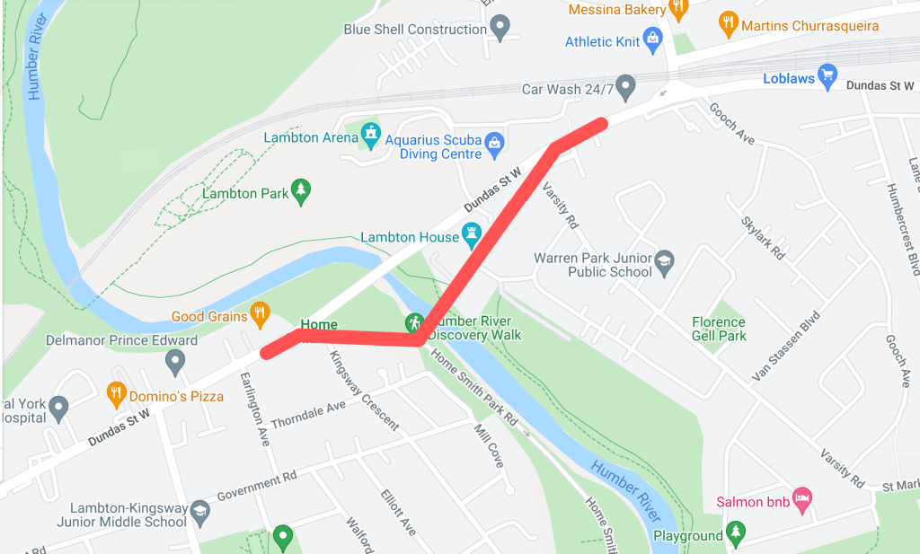
Historically, the main crossing over the Humber River on Dundas Street was located about two hundred metres south of the current bridge. This section of Dundas made up the old community of Lambton Mills and served as a main entrance into Toronto from the west on the Dundas highway. There were several versions of Dundas Street bridges here over the years — some made of wood, some iron, but all narrow for traffic and susceptible to the flooding waters of the Humber.
1924 Goads Fire Insurance Map of old course of Dundas Street. Source: Goad’s Toronto
In 1929, a new high-level bridge was completed over the Humber. This altered the main course of Dundas Street to the north. The old course became “Old Dundas Street”. For nearly thirty years, the two Dundas Street bridges existed alongside each other. In 1954, the devastating effects of Hurricane Hazel left the Old Dundas Street bridge in a dilapidated state; it was finally demolished several years later. Today, Old Dundas Street exists on both sides of the Humber River mostly as a quiet residential street. Lambton House, a historic inn turned museum, is a leftover of Old Dundas Street and Lambton Mills’ prominence.
“A New High-Level Bridge”, The Globe, January 16, 1929. Source: Globe and Mail Archives.1950 Aerial Image of Dundas Street and Old Dundas Street. Source: City of Toronto ArchivesOld Dundas Street, 2021. Source: Google Maps
Old Weston Road
Year rerouted: ~1948
Weston Road takes an interesting route through northwest Toronto, running diagonally through its street grid from the historic town of Weston (makes sense, eh?) and creating some unconventional intersections. North of St. Clair Avenue, the route of Weston Road was historically located east of the present road on the other side of the train tracks. It made up the historic village of Carlton with St. Clair and Weston as its nexus. It is highlighted by the still standing, yet altered Heydon House Hotel, built 1890. Weston then ran south to join with Dundas Street.
1851 JO Browne Map of Toronto showing Weston Road and the village of Carlton. Source: Old Toronto Map1927 Heydon House. Source: City of Toronto Archives
Around the 1890s, another “branch” of the street was built north from Keele Street running parallel to the railway on its west side. This street took on the name “Weston Road South”. In the 1910s, the street was completed to join with the main Weston Road.
1908 Map of Toronto showing Weston Road. Source: Old Toronto Maps1909 Map of Toronto showing Weston Road. Source: McMaster University1910 Old Weston Road bridge over C.P.R. Source: City of Toronto Archives
Perhaps because Weston Road South offered a more direct route south into the city, it formally became the more prominent road in the 1940s. First, an “Old Weston Road” began to refer to the section of Weston Road between the railway and Hillary Avenue. This meant that at one time a person could stand at the intersection of Weston Road, Old Weston Road, and Weston Road South. In 1948, Weston Road South became just Weston Road. Also, the entirety of the older eastern section of Weston Road was renamed Old Weston Road, save for the section between the tracks and Hillary which was added to Rogers Road. As the tracks to the south grew, the section of Old Weston near Dundas became severed from the rest of the road. Today, Old Weston Road is a mostly residential street.
1945 Map of Toronto showing Weston Road. Source: Old Toronto Maps1948 Toronto Transit Commission Map showing Weston Road. Source: University of Toronto Map & Data Library.1951 Map of Toronto showing Weston Road. Source: University of Toronto Map & Data Library.
Old Eglinton Avenue
Year rerouted: ~1957
For an east-west street that has become so vital to Toronto’s street grid and home to many neighbourhoods, it is difficult to imagine that Eglinton Avenue did not always exist in one harmonious stretch of road. However, it took some doing to make it into the street of today. Until the 1950s in the eastern half of Toronto, Eglinton Avenue terminated near Brentcliffe Road in Leaside and did not resume again until Victoria Park Avenue in Scarborough. The area in between them was about a five-kilometre stretch of farmland and two ravines — that is, both the east and west branches of the Don River. In the mid-1950s, a massive project was undertaken to join the two sections.
1950 Aerial Image of the future location of the Eglinton Avenue East extension. Source: City of Toronto Archives1953 Map of Metropolitan Toronto. Source: York University Archives 1954 Aerial Image of the future location of the Eglinton Avenue East extension. Source: University of Toronto Map and Data Library
While an “Old Eglinton Avenue” seems to come out of the events of the 1950s, it seems a little unclear why. The street runs parallel to the “new” road for about half a kilometre west from Bermondsey Road. Like the surrounding area, it mostly houses industrial buildings. As Eglinton did not seem to exist between Leaside and Scarborough (at least not in any formal sense), the story of Old Eglinton is a bit of a mystery. Hiking The GTA has located an old roadbed for an “Old Eglinton Road“. This may have been a farm road or a line that divided farm lots. It is also notable how Old Eglinton Avenue aligns with a “pencilled in” Eglinton Avenue between Victoria Park and Leaside, so a theory may lay in that idea.
Extension of Eglinton Avenue east across the West Don River, 1955. Source: City of Toronto ArchivesOld Eglinton Avenue, 2020. Source: Google Maps
Old York Mills Road
Year rerouted: ~1972
The valley near Hogg’s Hollow has proven to be an obstacle to road transportation several times in its history. As I previously noted, Yonge Street was realigned in 1835 after skirting east to better tackle the West Don ravine’s topography. Because of this same geography, Wilson Avenue terminated at Mason Boulevard, meaning there was no direct east-west crossing at Yonge Street as we know it today. In 1972, a project was undertaken to extend Wilson to meet with Yonge and York Mills Road.
1971 Aerial Image of York Mills Road and Wilson Avenue. Source: City of Toronto Archives“Extension of Wilson Avenue”, Toronto Star, May 28, 1972. Source: Toronto Star Archives
To make this extension happen, a curved road was constructed from Wilson Avenue which then crossed Yonge Street and joined York Mills Road between Campbell Crescent and York Ridge Road. This meant the straight section of York Mills near Yonge Street was effectively separated from the main route, becoming “Old York Mills Road”. Today, Old York Mills houses a trailhead, a passenger pickup zone for York Mills Station, a condominium, and a church.
Old York Mills Road and Wilson Avenue Extension, 1973. Source: City of Toronto Archives.
Old Kennedy Road
Year rerouted: ~1987
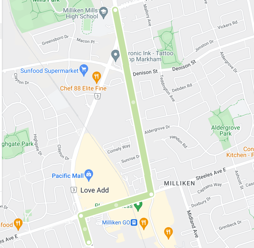
Kennedy Road just north of Toronto is a prime example of how of a noticeable curve in a street sometimes denotes a street was re-engineered. Kennedy existed in two separate sections north and south of Steeles Avenue, the Scarborough-Markham town line. The roads were about six hundred metres apart, meaning a northbound traveller from Scarborough had to jog east and then north again to continue into Markham. The area as a whole is and was known as Milliken, a historic community with the uncommon characteristic of existing within both municipalities.
1954 Aerial Image of Kennedy Road. Source: University of Toronto Map & Data Library
In 1987, the two sections of Kennedy Road were connected by a curving road running north from Steeles which veered east to meet the Markham section of Kennedy just north of the newly created Denison Street. The circumstances behind the re-alignment were unclear, but given Kennedy Road’s history as a ‘highway’ in Scarborough and the tendency in and around Toronto to harmonize streets within bordering jurisdictions, it is easily conceived why the jog was removed.
1987 Aerial Image of Kennedy Road. Source: City of Toronto Archives.
The eastern section of Kennedy became “orphaned” and was renamed Old Kennedy. Old Kennedy stops at Denison and continues on as Fresno Court, which in turn ends at a cul de sac. A fence separates it and Kennedy Road. Old Kennedy Road is an interesting mix of industrial and residential, with several older-looking houses near Steeles, perhaps lending back to the days when it was a hub in the village of Milliken.
Fresno Court, 2020. Source: Google Maps
Old Finch Avenue
Year rerouted: ~1993
Finch Avenue in Scarborough is relatively straight for much of its course from the North York town line to the Pickering town line — except in its most eastern part. Where Finch passed through Staines Road, the street at one time did a triangular job around the CPR tracks (the detour seems to have been created in the 20th century).
1916 Map of Townships, York, Scarboro, and Etobicoke. Source: University of Toronto Map & Data Library1954 Aerial Map Showing Finch Avenue. Source: Source: University of Toronto Map & Data Library
Further along, Finch did another jog up Sewell’s Road before meandering across the Rouge River and around its valley. It continued straight toward Kirkham’s Road (today’s Meadowvale Road). As there is today, there was an uncleared section of land across to Beare Road, thus one would have to jog up again to Plug Hat Road and back down to reach Finch again. The street resumed once more on its way to the Pickering Border. This stretch of Finch between Sewells and Kirkham’s made up the historic community of Hillside which had a church, school, and mill. The village made up much of the Rouge lands today from Sheppard Avenue/Twyn Rivers to Steeles Avenue.
1965 Aerial Image of Finch Avenue. Source: City of Toronto Archives.1969 City of Toronto Directory showing Finch Avenue. Source: Toronto Public Library
By the 1980s, changes came to Finch Avenue. Morningside Avenue curved from the south to meet Finch. Then, in or around 1993, the street was extended further north of Finch. This changed the alignment of the Finch/Staines intersection and effectively split Finch Avenue. Travellers moving east on Finch had to now follow the curving street north to Morningside Avenue and then curve back south via the same street. The east-west street on the other side was “Old Finch Avenue”, following the older, winding alignment. Because of this, the street bunks the trend of “old” streets which were leftover sections of the re-routed street; there is/was not ever a “newer” Finch Avenue that existed alongside the street. Old Finch terminates at Meadowvale Avenue; after Beare Road, it becomes Finch again and continues into Pickering for another eight kilometres.
“New Metropolitan Toronto Zoo Site”, Toronto Star, June 17, 1972. Source: Toronto Star Archives“Star Trek Run” Toronto Star, June 3, 1978. Source: Toronto Star Archives1983 Aerial Image of Finch Avenue. Source: City of Toronto Archives
Today, Old Finch is mostly known for its ‘haunted’ Bailey bridge and being the northern border of the Toronto Zoo, whose postal address is 361A Old Finch Avenue. The reconfiguration at Staines also facilitated the Morningside Heights neighbourhood.
“Grand Opening”, Globe and Mail, May 20, 1993. Source: City of Toronto Archives
2022 Finch Avenue. Source: Google Maps
The Older Finch Avenue
Year rerouted: 1977
Old Finch Avenue in the Rouge Valley was not the first Old Finch in the city. There was once a severed section of the street near Victoria Park in the old community of L’Amoreaux when the street was realigned directly across the Scarborough-North York border. This curved realignment eliminated a jog along the town line for east-west travellers. This Old Finch Avenue was closed in 1977; Pawnee Avenue roughly follows its old right of way.
1975 Aerial Image of Victoria Park and Finch Avenue Source: City of Toronto Archives
“Borough of North York Notice of Road Closing”, The Globe and Mail, September 9, 1977. Source: The Globe and Mail Archives
For a Google map of “Old” Toronto Streets, click here.
Map of “Old” Toronto Streets. Source: Google Maps Created by: Bob Georgiou
If you have any information to add or have any stories from any of these locations, leave a comment below or email bob@scenesto.com!
Toronto’s street grid is over 200 years old by colonial standards and even older with its Aboriginal trails. There have been additions and extensions, widenings and improvements. They have also been named to reflect the city’s past and present and it values (by those who do the naming, that is) – and to help the postal service.
The city is not a static object and neither are street names. Revisions and renamings have been an understated part of Toronto’s history. However, not all street renamings — proposed and actual — have gone over well. What is the mainly reason for this opposition? Simply put: History and Tradition. Whether successful or not, these episodes in Toronto’s history inform us how the city operated and why Toronto’s geography is as it is today.
Here are seven examples of controversial street name changes:
Old and New St. Patrick Street
In 1917, modern Dundas Street was created by amalgamating and connecting several smaller streets. One of these roads was St. Patrick Street, which ran between McCaul Street and Bathurst Street.
St. Patrick Street looking west to Spadina Avenue, circa 1911. Source: City of Toronto Archives 1913 Goad’s Fire Insurance Map. Source: Goad’s Toronto
One group opposed to changing St. Patrick to Dundas was the St. Patrick’s Old Boys’ Association, which attended the old St. Patrick’s School on William Street. The group deputed to City Council, but was unsuccessful. The story was not all bad as William Street was later renamed to St. Patrick Street to keep the tradition.
Dundas Street, looking east towards McCaul Street (home of St. Patrick’s Church with the new St. Patrick’s Street behind it), 2021. Source: Google Maps
Mimico Mixups
In 1929, a dispute over the renaming of 54 Mimico streets spanned several council meetings. At issue, Toronto’s postal service requested the changes after Mimico and Long Branch were placed in the Toronto postal region. The difficulty was the added municipalities added duplicate street names to the region and potential confusion for postal workers. An ex-mayor attended a September 1929 council meeting arguing why the inclusion of ‘Mimico’ in the mailing addresses would not be sufficient enough for postal workers. Matters got heated in an October meeting when Mimico Mayor and Liberal candidate W.A. Edwards accused Minister of Health and Conservative candidate Dr. Godfrey of “insincerity” when Dr. Godfrey opposed the name changes when the mayor rejected Dr. Godfrey’s wish to have Stanley Avenue changed to Godfrey Crescent.
1924 Goad’s Fire Insurance Map Source: Goad’s Toronto
It is unclear whether the by-law change went through, but in the October council meeting, it was moved and seconded that a second reading for the proposed by-law change be conducted. The Mimico street grid remains generally intact since the 1920s, albeit with notable changes: Church Street is now Royal York Road, Salisbury Avenue is now Park Lawn Road, Brant Street is now Dalesford Avenue, and Winslow Avenue is now Douglas Avenue.
Mimico, 2021. Source: Google Maps
Long Branch Street Changes & Disappearances
In 1952, a ratepayers association in Etobicoke protested the changing of part of Lake Promenade Road to Island Road in Long Branch. Lake Promenade existed in two sections on either side of the main branch of Etobicoke Creek, running all the way to Applewood Creek. To eliminate confusion for postal workers, it was proposed for the western section of Lake Promenade be added to Island Rd, which it already connected to.
1953 Aerial Image Source: City of Toronto Archives
Residents of Island Road did not like the idea as a recent storm severely damaged and condemned several homes on Lake Promenade and the association with that event to their properties was unwanted. The change ultimately took place by 1955, although it ultimately did not matter as the fallout of Hurricane Hazel caused the expropriation of homes on Island and Lake Promenade near Lake Ontario and Etobicoke Creek, as well as the complete removal of Lake Promenade west of Forty Second Street, James Street west of Forty Second Street, all of Forty Third Street, and Island Road parellel to the lake. Today, much of the area is parkland.
2022 Aerial Image. Source: Google Maps
The Pioneers of Scarborough
In 1957, Scarborough Council was tasked with submitting a list of alternate names for 210 streets duplicated elsewhere in the City. Metropolitan Toronto was standardizing operations and services across the city in the decade, including eliminating duplicates of street names.
1957 Map of Metropolitan Toronto Source: University of Toronto Map & Data Library
Confusion over postal delivery was again at issue, but names on the list included Brumwell St, Cornell Avenue, Harris Avenue, Kennedy Road, Little’s Road, Lennox Avenue, Muir Drive, and Paterson Avenue — streets named for Scarborough pioneers. Most streets seem to exist today, save for Lennox Avenue and Agincourt’s Paterson Avenue, which became Reidmount Avenue.
Kennedy Road, looking south to Reidmount Avenue (which amalgamated with the former Paterson Avenue), 2021. Source: Google Map
The Many Orioles
In 1958, duplication was at issue again in midtown Toronto with a proposal to rename the similarly named Oriole Crescent, Oriole Gardens, and Oriole Road. The names were to become Holmfield Crescent, Lower Canada Gardens, and Campus College Road, respectively.
1957 Map of Metropolitan Toronto. Source: University of Toronto Map & Data Library
Fifteen “angry” women of the three streets united to protest the move, even going as far as saying they’d be willing to go to jail for taking down the new signs if they ever went up. They cited the beauty, history, and fame of the “Oriole” name and the inconvenience it’d cause for people living on those streets to having to change addresses on documents. Ultimately, the names remained as they were and as they are today.
Looking east down Oriole Gardens at Oriole Road, 2021. Source: Google Maps.
A Mega-Maxome Avenue
In 1962, Willowdale residents protested the renaming and merger of Halstead and Maxome Avenue to Harkness Street. The three streets were disjointed and together would “form a mile long thoroughfare north of Finch Avenue.”
1955 Map of Metropolitan Toronto. Source: University of Toronto Map & Date Library
A resident of Maxome, representing 37 others on the street, argued the historical naming of the street, which was honouring a surveyor who laid out the original blocks of the area. Ultimately, the proposal did not go through. Curiously, Halstead and Harkness have disappeared from the map, having the name Maxome Avenue instead. Today, Maxome has a windy course, like it was strung together from a few different streets, creating a mega-street of sorts.
Maxome Avenue, 2021. Source: Google Maps.
North York Pioneers
In 1979, Scrace Hill Drive in North York was renamed to Skymark Drive, prompting the opposition of the Scrace family. The Scarces had historical roots in the Finch Avenue and Leslie Street area formerly known as L’Amoreaux, donating land for a church and cemetery, still standing today as Zion Church.
1916 Map of The Townships, York, Scarborough, and Etobicoke. Source: University of Toronto Map & Data Library
The family wrote North York Council a letter, outlining the connection and how several Scraces were even on North York Council. The street was renamed to Skymark after the development on the street, as the old street had a confusing spelling and was not easy to find. North York Controller Esther Shiner said the new name was “such a pretty name” and she would find something else to name after the Scraces. Of irony, Esther Shiner would later become the subject of a street herself.
Skymark Drive, 2021. The Skymark Towers are behind the shot. Zion Methodist Church is on the left. Source: Google Maps.
Sources Cited
“Citizens Protest Against Change In Street Name.” The Globe, 9 Oct. 1952, p. 12.
“’Godfrey Crescent’ Causes Verbal Tilt At Mimico Council.” The Globe, 15 Oct. 1929, p. 16.
“Keep Traditions: Opposes Renaming Traditions.” The Globe, 6 Mar. 1957, p. 4.
“Petty Politics Involved In Changing Street Names.” The Toronto Daily Star, 15 Oct. 1929, p. 5.
“Sees Lakeshore Trustees ‘Trying to Hoodwink Us’.” The Toronto Daily Star, 9 Oct. 1952, p. 26.
“St. Patrick Old Boys Form Strong Body.” The Globe, 7 Apr. 1917, p. 21.
“Street Name Change Bruises Family Pride.” The Globe and Mail, 10 Dec. 1979, p. 4.
“Street Name Change Fought By Residents.” The Globe, 8 Feb. 1962, p. 4.
“Would Go To Jail: 15 Angry Women Save Their Street Names.” The Globe, 5 June 1958, p. 23.
When one thinks of the history of Scarborough, the intersection of Midland Avenue and the 401 might not be the first thought. However, a site that once stood there for more the half the 20th century literally put the local community on the international scientific map. This was the Agincourt Magnetic Observatory.
Aerial image of the Agincourt Magnetic Observatory, 1957. Source: City of Toronto Archives
The story of the Agincourt Magnetic Observatory begins not in Scarborough, but on the grounds of King’s College in downtown Toronto in 1840. The school became the University of Toronto in 1850. Contrary to the dense district of today, the university was then sparsely populated – in other words, perfect conditions to minimize interference. The University granted 2.5 acres for a site that was located on the southwest side of today’s King’s College Circle.
“The Old Toronto Observatory” painted by William Armstrong, 1852. Source: University of Toronto Archives
Boulton Atlas, 1858. Source: Goad’s Toronto
The Globe described the laboratory:
“The first observatory was of logs, rough cast on the outside and plastered on the inside; it was completed during the summer of 1840 and observations were begun in September.”
The Globe, October 1, 1898
University of Toronto Campus Map, 1859. Source: University of Toronto Archives
The second observatory was built in the autumn of 1853, replacing the wooden observatory on the same site. It was built of stone and the nails and fastenings were of copper and zinc.
The Toronto Observatory as seen looking south from University College, 1857. Source: Toronto Public Library.
Dominion of Canada Observatory, 1880s. Source: University of Toronto Archives
In 1892, Toronto’s growing infrastructure began to spell the beginning of the end for the observatory. To be sure, as early as 1876, new structures on the university grounds began to impact the observatory, but it was nothing like the electric railway to come. Streetcars were electrified, first beginning with the Church Street line opened on August 17, 1892, and then the College Street line only steps from the building. Instead of recording magnetic changes, the observatory recorded the starting and stoppings of the trolleys. In 1896, Sir Frederick Stupart, the director at the observatory, took up the issue with the government. There would be no action until a report was received from a committee of meteorologists visiting from England that year. This report recommended the centre be moved far away — to Scarborough.
Goad’s Fire Insurance Map, 1889. Source: Goad’s Toronto.
The observatory was relocated just south of the Agincourt Village centre at the current intersection of Midland Avenue and Sheppard Avenue where a Presbyterian Church and nearby Canadian National and Canadian Pacific stations stood. It was perfect in that no electric railway lines existed – at least not in seven miles and there was little prospect of any lines for many years (the railway did not interfere either). The observatory stood in a 4-acre field at the north end of the southern half of lot 16 (Midland Avenue) and Concession II (Ellesmere Avenue), belonging to the Forfar family. It was constructed over the summer of 1898 and opened in September. The first observations were made on September 10 and by the end of the month, all instruments had been moved from Toronto to the new site.
Map of the Townships, York, Scarboro, and Etobicoke, 1916. Source: University of Toronto Map & Data Library
Aerial image of the Agincourt Magnetic Observatory, 1947. Source: City of Toronto Archives
This Observatory was described in The Globe:
“…[It] consists of two parts, a circular stone collar nineteen feet in diameter, the walls two feet in thickness, the floor concrete and the roof covered with felt and gravel, in which on stone piers sunk in concrete to a depth of six feet below the floor are place the self-recording photographic instruments, namely, the declinometer for recording changes in the direction of the magnetic needle and the bifilar and vertical force instrument, for registering respectively changes in the horizontal and vertical components of the earth’s magnetism: above ground and connected with the cellar by a flight of steps is an erection which divided into two portions, in the larger of which absolute magnetic determinations will be made, piers being provided on which to place the necessary instruments, and an adjustable opening on the roof for transit work – and the smaller, an office, which will be heated by a copper stove.”
The Globe, October 1, 1898
Meteorological buildings, Scarborough, 1917. Source: City of Toronto Archives
The Agincourt Magnetic Observatory, The Globe and Mail, November 26, 1952. Source: Globe and Mail Archives
Basement of Magnetic Building, Agincourt, early 20th Century. Source: City of Toronto Archives
The old Toronto Observatory continued to serve as the central office of the Dominion Meteorological Service. All photographic records from Agincourt were sent there for development. It also conducted astronomical studies. In 1908, the observatory was dismantled to accommodate an extension to King’s College Circle and possibly a new physics building. It was reconstructed brick by brick near Hart House, where it stands today as a students’ union. Some installations stand near its former location between Convocation Hall and the Sandford Fleming Building.
Convocation Hall – East side and Old Observatory, 1907. Source: University of Toronto Archives
Goad’s Fire Insurance Map, 1930. Source: University of Toronto Archives
Louis B. Stewart Observatory (UTSU), 12 Hart House Circle, 1980s or 1990s. Source: City of Toronto Archives
In 1899, severe earthquakes in Alaska were recorded at the Agincourt Magnetic Observatory. In 1903, the observatory recorded the largest magnetic storm on October 30 and 31, which Director Stupart “intimately” connected sunspots and magnetic disturbances on earth. The centre recorded more such magnetic storms attributed to sun sports on Aug 8, 1917. The Agincourt labs were useful in World War II against Germany for “calibration of master compasses and other apparatuses”.
The Toronto Daily Star, September 12, 1917 Source: Toronto Star Archives.
The Globe and Mail, November 26, 1952. Source: Globe and Mail Archives
The significance of the Agincourt Magnetic Observatory and its activities were very well documented and even world-renowned. In 1919, the Observatory was threatened by a proposed Toronto to Port Perry Hydro Radial, which had officials looking for a new site where electricity would not penetrate that observatory’s environment. It was of significant alarm as the Agincourt Magnetic Observatory was one of two of its kind in Canada and by far the more important of the pair. In 1957, a contagion of scientists from around the world visited Agincourt as a part of some sessions by the International Union of Geodesy and Geophysics held at the University of Toronto. They asserted that they knew Agincourt better than Toronto as the village appeared in “thousands of International Geophysical maps” around the world.
Despite its importance, city growth once again spelled the end for the site. Meeting a similar fate to the Toronto Observatory seventy years before, the Agincourt Magnetic Observatory closed in March 1969. In the 1950s, Highway 401 was constructed next to the laboratory. Farms adjacent to the observatory began to turn into housing. Factories were built on either side of the property in the 1960s. On July 1, 1968, a new observatory opened in Ottawa. By 1971, the Agincourt structures were gone completely. Today, government offices stand in its place, hiding the great landmark once housed there.
Aerial image of recently demolished Agincourt Magnetic Observatory, 1971. Source: City of Toronto Archives.
Site of Agincourt Magnetic Observatory, 2022. Source: Google Maps
Works Referenced
“Astronomical Conversation.” The Globe, 21 Jan. 1903, p. 12.
“Chilly Weather.” The Globe, 14 Dec. 1898, p. 2.
Dobson, Jack. “Magnetic Observatory One of Canada’s First.” The Globe and Mail, 26 Nov. 1952, p. 3.
Government of Canada, Natural Resources Canada. “Government of Canada / Gouvernement Du Canada.” Government of Canada, Natural Resources Canada, Canadian Hazards Information Service, Government of Canada / Gouvernement Du Canada, 1 Mar. 2019, https://www.geomag.nrcan.gc.ca/obs/ott-en.php.
In the first half of the twentieth century, automobiles had quite an impact on the streets of Toronto. In 1913, there were 17,000 cars in Toronto; by 1923, the number grew to about 50,000 cars. New rules and technologies were adopted to better manage and regulate how motorists behaved, especially concerning the other users of the road and their safety.
Traffic conditions, Adelaide and Bay, 12:10, (Executive Department), 1927. Source: City of Toronto Archives
Traffic Lights: A Most Beneficial System
On August 8, 1925, Torontonians were introduced to their first set of automated traffic signals. The new ‘semaphores’ were set up at the busy intersection of Yonge Street and Bloor Street on a trial basis and changed the history of Toronto’s streets forever. It was at least three years in the making, with Toronto Chief of Police Samuel J. Dickson advocating for and finally receiving the system in that time.
“Traffic Control by Lighting System” The Toronto Daily Star, August 8, 1925. Source: Toronto Star Archives
“Traffic Control by Lighting System” The Toronto Daily Star, August 8, 1925. Source: Toronto Star Archives
Before traffic lights, intersections were regulated by traffic policemen. In the 1910s, this was done largely through hand signals, whistles, and yelling. In 1920, a new ‘semaphore’ was piloted (again at Yonge and Bloor) which consisted of the officer controlling a staffed sign with the words “STOP” and “GO” written on them. The officer rotated the sign to control the flow of traffic. If one peruses archival photos of highly trafficked Toronto intersections, it is common to see a police officer amid the action.
Southwest corner of Yonge and Bloor streets, 1923. Source: City of Toronto Archives.
“Semaphore on Trial”, The Toronto Daily Star, June 6, 1920. Source: Toronto Star Archives.
The new traffic lights were an overall success. Automated signals were installed on major junctions along Yonge Street, Bloor Street, and Danforth Avenue, and in suburbs such as East York within the next few years after their introduction. As an example of the new semaphores’ impact, The Globe reported in December 1929, the intersection of Bloor Street and Keele Street had an average of 4 or 5 accidents a day before automated signals were installed there in 1927; there were no accidents after that point.
Police Chief Dickson even dreamed of a master tower at Yonge and Queen to control all the lights in the city. The idea became a reality at the end of 1926. There was even synchronicity within the lights: a motorist travelling straight on Danforth Avenue between Main Street and Broadview Avenue in 1928 was able to meet all green lights if he travelled at 19 or 20 miles per hour; any slower or faster, the driver would hit a red light (the speed was 18 miles per hour downtown).
Automatic traffic signal, King and Yonge, 1927. Traffic Lights were switched to a vertical orientation and a yellow/amber ‘warning’ light was formalized several years after 1925. Source: City of Toronto Archives.
Of course, several early reports indicated that the new lights were not all good. Even the Mayor weighed in, saying to the Police Chief in October 1925 that officers were still stationed at the Yonge and Bloor ‘experiment’, seemingly defeating the Chief’s goal of having the technology free up more policemen from traffic duty. Sometimes they did not function properly or at all, as The Globe reported in July 1928 of the new, often “stuck” Dundas Street East signals. But despite these complaints, the lights were there to stay; 96 signals were installed in Toronto by the end of the 1920s.
Queen and Yonge, looking west, traffic, noon – 1 p.m., (Executive Department), 1929. Despite the functioning green light, an officer monitors the traffic. Source: City of Toronto Archives
Bloor and Yonge streets, southwest corner, 1928. One compare the crossing to the earlier 1923 image. Source: City of Toronto Archives
The ‘Right on Red’ Rule
One of the most interesting impacts of the rise and success of traffic lights was a ‘new’ law that permitted a motorist to make a right-hand turn against a signal that would otherwise make him wait at the intersection. This is the ‘right on red’ rule. On March 22, 1927, Police Chief Dickson announced the reinstatement of the permission, indicating that it was actually in effect “some time ago” and the success of the new lights could now allow for it once more. It is unclear what period the rule was previously in place or why it disappeared, although reckless driving at unmanned intersections is a theory for its removal.
Corner of King and Yonge streets, 1910. Note the right-turning vehicle. Source: City of Toronto Archives
The ‘right on red’ permission was not without controversy, even with the police itself. The organization vowed to watch right-turning drivers and warned them to prioritize the safety of pedestrians who had the right of way to cross the street.
In July 1928, new Police Chief D.C. Draper reiterated motorists were allowed to turn right at a “hostile” light, having “regard” of other cars and pedestrians who have the right of way. However, in March 1929, Draper advocated against the rule. In a report by the Traffic Committee, which monitored Toronto streets for more than a month for traffic improvements, the Chief suggested, among other items, the discontinuance of “the present practice of motorists making a right-hand turn against the red light” or “otherwise give them a warning that the pedestrians have the right of way, and that right-hand turns against a red signal are only allowed when care is exercised”. The Board of Control ultimately went against the Chief and retained the rule while reiterated motorists were responsible for pedestrian safety.
King and Yonge streets, northwest corner, looking west, 1912. Source: City of Toronto Archives
Interestingly, in Hamilton, which was the setting of Canada’s first traffic lights just two months before Toronto’s semaphores were installed, the Traffic Committee wanted to abolish the rule which allowed right-hand turns on red lights in 1933. Oddly, it was met with disapproval from the Ontario Department of Highways. The by-law ultimately remained.
Despite many calls in Toronto in the decades since to remove the permission for good, the Highway Traffic Act currently upholds it in Ontario:
s. 144 (19) Despite subsection (18) and subject to subsection (14) [Green Arrows], a driver, after stopping his or her vehicle and yielding the right of way to traffic lawfully approaching so closely that to proceed would constitute an immediate hazard, may,
(a) turn to the right; or
(b) turn to the left from a one-way street into a one-way street,
without a green indication being shown.
Traffic conditions, Adelaide and Bay, 1210, (Executive Department), 1927. Note the traffic light and police officer on horseback. Source: City of Toronto Archives
To Stop or Not?
Another interesting question arose on the requirement to stop before turning right. In November 1927, a person writing into The Toronto Daily Star‘s “Voice of The People” section was puzzled by the different standards of when there was a stop sign at an intersection (which he interpreted as ‘stop means stop’) and when there was a policeman with a semaphore (which he interpreted as ‘stop means stop sometimes‘). The editor replied that when an officer was holding the semaphore, he supervises traffic and allows right turns without stopping. When there is no officer, all cars must stop.
Southeast corner of Bloor and Yonge streets (Imperial Bank of Canada), 1924. Source: City of Toronto Archives
Within Toronto City Hall, the issue of drivers legally passing through a red light to turn right was debated for several years. In July 1929, Toronto’s Traffic Committee suggested an amendment of certain by-laws to protect pedestrians, including motorists were to come to a stop before making a right-hand turn against the red light. It did not seem to have made an impact. In December 1933, the idea was raised again, this time proving more successful. The Board of Control favoured a change to the by-law so that every driver must come to a full stop before making a right turn at an intersection controlled by automatic traffic signals. The change seemed to be spurred by complaints that motorists were not heeding the way to pedestrians and “showing no consideration for the pedestrian”. City Council adopted the change on December 12th of the year, subject to approval by the Department of Highways.
“City of Toronto Traffice By-Laws”, The Toronto Daily Star, March 2, 1933. Source: Toronto Star Archives
Inexplicably, the rule was changed back only four months later. In April 1934, the by-law requiring motorists to make a complete stop before a right turn at a red light was rescinded. The Board of Police Commissioners instructed police officers to safeguard the rights of pedestrians once more.
It is unclear when exactly the law reverted once again, but it seems the matter was not closed. The idea seemed to be backed in other circles, too. In a February 1934 meeting of the Ontario Motor League, a suggestion was advanced that those turning right in the province should come to a full stop at both a red land green light. In 1938, a reader of The Globe and Mail expressed his displeasure in the lack of pedestrian rights in motorists not having to stop before right turns. A decade later, in July 1948, the same newspaper rode along with Toronto Traffic Safety Council Inspector Vernon H. Page in a motor car as he pointed out traffic infractions, including those failing to come to a full stop before a right turn, meaning by this point the law was reinstated.
“Camera Catches Motorists, Pedestrians Breaking Rules”, The Globe and Mail, July 20, 1948. Source: Globe and Mail Archives
Today, of course, a red light does indeed mean ‘stop’ in all contexts, as the Highway Traffic Act so states:
s. 144 (18) Every driver approaching a traffic control signal showing a circular red indication and facing the indication shall stop his or her vehicle and shall not proceed until a green indication is shown.
Yonge Street and Queen Street, southeast corner, 1915. Source: City of Toronto Archives
Works Referenced
“24-Hour Operation Of Traffic Signals Proves Successful.” The Globe, 28 July 1928, p. 13.
“24-Hour Police Service, East York, Authorized; Other Changes Urged.” The Globe, 18 Jan. 1929, p. 13.
“Allow Right Turn Against Red Light.” The Toronto Daily Star, 22 Mar. 1927, p. 3.
“Automatic Control Of Central Traffic Assured InToronto.” The Globe, 20 Mar. 1926, p. 14.
“Automatic Control Of Toronto Traffic To Be Inaugurated.” The Globe, 5 Nov. 1926, p. 11.
“Automatic Signals To Be Installed At Fifty-Five More Intersections Controlling All Main Street Traffic.” The Globe, 10 Mar. 1928, p. 8.
“Automatic Signals Will Operate Today At Bloor And Yonge.” The Globe, 8 Aug. 1925, p. 13.