What is the first street in downtown Toronto recorded as a one-way street? The answer is not obvious – perhaps because the street itself is not very consequential for most travelers today. It was the first chapter in the history of Toronto’s uniquely directed roads.
On July 2nd, 1901, By-Law No. 4108 prohibited “the conveyance of traffic on Leader Lane, from the south to the north.” The street ran, as it does today, between King Street and Wellington Street just west of Church Street. The reason for the ban against northbound traffic was that the lane was “too narrow for the passing of one vehicle by another.” Vehicles were defined in the law as horses, carriages, wagons, or other vehicles (other than a bicycle).
1858 WS Boulton Map Leader Lane was once named Berczy Street.
The issue came about when Mr. George R. R. Cockburn raised a complaint to the mayor:
“The fact that vehicles of every description are entitled to pass up and down Leader lane causes great inconvenience both to those using them and also to foot passengers, and it would be in the interests of the city that the traffic of carts and vehicles should be constrained to pass only from north to south through the lane. I may say that already two panes of glass have been broken by vehicles attempting to pass one another in so narrow a space.”
Toronto Daily Star, October 9, 1900
Leader Newspaper Office, King Street East, southwest corner Leader Lane. Toronto Public Library
Cockburn was a Member of Parliament in Toronto and educator, who was Principal at Upper Canada College and a member of the Senate at the University of Toronto.
By the spring of 1901, legislation was passed to allow Toronto to make the by-law and the Works Committee recommended the prohibition. It was given its readings in Council before being passed into law on July 2.
Leader Lane was named for the Toronto Leader Newspaper, which operated between 1853 and 1878 and had its offices at 63 King Street East and 40 & 44 Colborne Street. It had the previous names of “Old Post Office Lane” and “Berczy Street.” In 1909, Leader Lane was named by the Daily Star as the narrowest way in Toronto to be properly called a street.
While it is natural to think of the regulation in modern terms, this prescription of vehicles implies that automobile traffic was not the by-law’s first intention. But soon, it would be.
The “horseless age” was about to begin in Toronto. In August 1897, The Globe wrote of the interest derived from the presence “of an automobile vehicle, or motocycle, or autocar, the name being as yet unfixed.” In June 1901, the Toronto Automobile Club had its first rendezvous — a cavalcade of eight cars starting at Queen’s Park and driving around Toronto. Its president was John Craig Eaton — then Vice-President (and soon-to-be President) of the T. Eaton Company.
The following decades saw a growth in cars on the streets of Toronto and it was transformational for daily life in Toronto. In 1913, there were 17,000 cars in Toronto; by 1923, the number grew to about 50,000 cars. With it, Toronto refined its rules of the road and its technologies to manage traffic flow. The first version of the modern traffic light arrived in 1925.
On August 5, 1920, By-Law 8485 “To Regulate Traffic on the Public Streets” was passed. It focused on parking allowances and prohibitions, turning and stopping, obeying signals, and even regulated pedestrians (including bicyclists).
It also transformed a number of streets into one-way streets. The list included Leader Lane and many of its surrounding streets and lanes in the financial district: Victoria Street, Colborne Street, and Jordan Street. Other additions included Queen’s Park and Spadina Crescents, which were separated into north- and south-bound streets on either side of their respective islands.
Toronto Daily Star, March 2, 1933
The changes must have spurred a larger discussion about traffic measures. In a traffic conference in June 1923, more one-way streets were urged, including Yonge Street during peak times when parking provisions on the street were also reformed to allow the change. It was the first of nearly a century of schemes and ideas to make Yonge Street one directional. In 1928, the former Chief of Police Samuel J. Dickson raised the idea of making all traffic on Yonge Street travel south between Front Street and St. Clair Avenue. Conversely, strictly northbound traffic would travel along Bay Street, Davenport, and Poplar Plains Road.
Yonge Street looking north from King Street, 1924 City of Toronto Archives
Proposals and studies for a one-way Yonge Street arose in nearly every decade in the 20th century. Some, such as in 1968 and 1984, actually came with the idea of reducing the lanes on Yonge and improving the pedestrian arena with wider sidewalks and even pedestrian-only areas. In 1988, it arguably came the closest to a reality: Toronto City Council voted to turn Yonge Street into a northbound road (with Bay Street handling southbound traffic) on a trial basis. However, downtown businesses challenged the plan in court and won. The plan was killed in another council vote in 1989. Most recently, in May 2012, City Councilor and Public Works Committee chair Denzil Minnan-Wong proposed a one-way Yonge, but there was no follow-through. Interestingly, the counter-argument from a fellow councillor was similar to that of businesses in 1988: it would have been disruptive to local commerce.
Other major streets were also targets for traffic regulation reform in the 20th century — to more success. In 1946, the Civic Works Committee recommended one-way traffic on Adelaide and Richmond Streets. The former would apply from York to Jarvis Streets; the latter from Jarvis to University Streets. Unfortunately, while a trial period was proposed, the idea was seemingly forgotten for more than a decade. On Sunday, May 4, 1958, the pilot on Adelaide and Richmond finally began; it was filled with confusion and wrong-way turns. But by Monday, the test was already declared a success by city officials, the Toronto Transit Commission, and Toronto Police. By-Law No. 20418, passed on September 2, 1958, included Richmond, Adelaide, and roughly three hundred entries (that is, also including lanes and parts of streets) under Schedule VIII for one-way streets. The success seemed to have spurred further proposals to create a network of one-way streets in Toronto, which was layered with the movement for expressways as a means of allowing better and safer traffic flow. Today, vehicles in the downtown core travel uniquely west on Richmond Street and east on Adelaide Street.
Globe and Mail, May 5, 1958
Today, Toronto’s main streets do not follow a strict network of one-way streets as other Canadian and American cities have adopted. As with many civic improvement projects in Toronto, the approach to the one-way regulation seems to have been a gentle one: beginning small with narrow streets around the financial district and increasing to large changes like Richmond and Adelaide Streets when political appetite allowed it. In that way, Leader Lane truly was a leader.
A special thank you to Francesca Bouaoun of the Toronto Archives and Tony Masucci of By-Law Support for their assistance in retrieving archival by-laws.
Sources
“1-Way Yonge Street South from Davenport Recommended in Study.” Globe and Mail, 26 Mar. 1968, p. 5.
“A Downtown Essential.” The Globe and Mail, 1 Dec. 1959, p. 5.
“After Erring Autoists.” The Globe, 01 June, 1921, p. 9.
“An Automobile Club.” The Globe, 21 Jun. 1901, p. 10.
Baker, Alden. “Expanded one-way street system could be key to narrower Yonge.” The Globe and Mail, 27 Mar. 1984, p. M3.
“Bold Tactics Called For.” Globe and Mail, 5 Oct. 1951, p. 6.
“City Asks Changes In Municipal Act.” Toronto Daily Star, 18 Feb. 1920, p. 2.
City of Toronto, By-Law No. 4108, To regulate the traffic of Leader Lane (2 July, 1901)
City of Toronto, By-Law No. 8485, To regulate Traffic on the Public Streets (5 August, 1920)
City of Toronto, By-Law No. 20418, To regulate traffic on roads (2 September, 1958)
“City of Toronto Traffic By-Law.” Toronto Daily Star, 2 Mar. 1933, p. 12.
“Congestion of City Streets Demands Control of Traffic.” The Globe, 11 Jul. 1925, p. 13.
“Crosstown Project, One-Way Street Plan, Suggested For City.” Globe and Mail, 10 May. 1962, pg. 5.
“Deer Park Plan: One-Way Yonge St. Would Border Plaza.” Globe and Mail, 20 Sept. 1961, p. 5.
“Demanding Full Consideration.” The Globe and Mail, 1 Feb. 1949, p. 6.
“Discussion Begins Monday” The Globe and Mail, 24 Mar. 1972, p. 5.
Doolittle, Robyn. “Should Yonge, Bay Be One-Way.” Toronto Star, 9 May 2012, pp. GT1–GT2.
“Downtown One-Way Traffic Urged.” The Globe and Mail, 1 Nov. 1946, p. 25.
“Echoes 1968 Plan: One-Way Yonge, Church Proposed.” The Globe, 8 Feb. 1972, p. 5.
“Features About Toronto Streets.” Toronto Daily Star, 9 Jan. 1909, p. 4.
Georgiou, Bob. “A Quick Early History of Toronto’s First Traffic Signals and the ‘right on Red’ Rule.” Scenes From Toronto, 30 Jan. 2022, scenesto.com/2022/01/30/a-quick-early-history-of-torontos-first-traffic-signals-and-the-right-on-red-rule/.
“A Horrible Waterfront.” The Globe, 27 Apr. 1901, p. 26.
“If Yonge Were a One-Way Street.” The Globe, 10 Mar. 1928, p. 17.
MacKenzie, James. “One-way Street Scheme.” The Globe and Mail, 4 Oct. 1970, p. 5.
McIntyre, A. Lorne. “One-Way-Traffic Suggestion Would INclude Street Cars.” The Globe and Mail, 25 Aug. 1938, p. 1.
“More Study Required.” The Globe and Mail, 29 Apr. 1947, p. 6.
“Morning South, Night North Yonge Street One-Way Plan.” Globe and Mail, 17 Feb. 1954, p. 1.
“Motor Car Records Put Toronto Ahead.” The Globe, 28 Nov. 1919, p. 17.
“Old Habits Hard to Break.” Globe and Mail, 6 May 1958, p. 1.
“One-Way Roads For Downtown Urged.” The Globe and Mail, 11 Apr. 1963, p. 5.
“One Side of Yonge To Be Kept Clear.” The Globe, 6 June 1923, p. 13.
“One-Way Streets Speed Traffic in U.S. Cities.” The Globe, 23 Aug. 1947, p. 3.
“One-Way Traffic Experiment Given Sunday Sendoff.” Globe and Mail, 5 May 1958, p. 19.
“One-Way Traffic on Richmond, Adelaide Urged.” Globe and Mail, 5 Feb. 1958, p. 4.
“One-Way Traffic On Yonge Studied.” Globe and Mail, 2 Mar. 1954, p. 5.
Taylor, Paul. “City Votes to Make Yonge, Bay One-Way.” Globe and Mail, 17 May 1988, p. A1.
Taylor, Paul. “Toronto Council Rejects One-Way Yonge Street.” Globe and Mail, 24 Feb. 1989, p. A14.
“Telephone Agreement.” The Globe, 28 May 1901, p. 8.
“To Clear Taxis Off K.E. Stand.” The Globe, 10 July 1920, p. 6.
“The Horseless Age.” The Globe, Aug 28, 1897, p. 15.
“Toronto Motor Car Increase 305 Per Cent Since 1920.” The Globe, 16 Aug. 1938, p. 1.
“Traffic May Be One Way, Reverse on New Yonge St.” Globe and Mail, 14 May 1953, p. 29.
“Wagons in Leader Lane.” Toronto Daily Star, 9 Oct. 1900, p. 3.
“Watch One-Way Streets in City.” The Globe, 2 Oct. 1920, p. 20.
This is the third article in a series explaining the origins and histories of “Old”-named streets in Toronto. Here is Part I and Part II. You will find an interactive map of the title image here.
Old Kingston Road
Year rerouted: 1922
Kingston Road once followed a “tortuous” route into the Highland Creek valley, also called the ‘West Hill Hollow’. After it passed through the village of West Hill at Morningside Avenue, it took “a sharp, twisting drop down the bank of the valley.” It then followed the floor of the valley in a straight line and crossed over the creek on “a small, concrete bridge.” Up the eastern side, the hill was straight, but with its heavy level of traffic in the summer and its steepness and low visibility, it made for a dangerous drive.
1878 Illustrated Historical Atlas of the County of York, 1878 Source: Old Toronto Maps
In early 1922, tenders called for a high-level bridge. Construction began with the expectation that the road would be ready the next year. Fortunately, the project was completed quickly and was ready in November 1922. The new route, located south of the old one, added 6,000 feet of new road.
Map of Township of Scarboro, 1933 Source: University of Toronto Map & Data Library
Today, the old route – Old Kingston Road – passes several heritage structures and offers a neat, rural drive. It is a reminder of old Scarborough.
Old Kingston Road over the Highland Creek, 2021. Source: Google Maps
Old Forest Hill Road
Year “rerouted”: 1927
The present Forest Hill Road and Old Forest Hill Road have convoluted histories and geography, which involve the absorption, deletion, and renaming of other roads. The story of Old Forest Hill Road is unlike any of the other “Old” Streets as its changing from old to new (or new to old) did not seem to correct an inconvenience in geography.
In short, a 19th-century largely diagonal road ran through the Baldwin Estate north of St. Clair Avenue to Eglinton Avenue. In the early 20th century, a second road, which may or may not have been part of the old road, grew concurrently with it. While these were both Forest Hill Roads, in the 1920s, the ‘ancient’ road was formalized Old Forest Hill Road.
Tremaine’s Map, 1860 Source: Old Toronto Maps
The Baldwin footpath of the 1800s was originally called the “Trespass Road” (albeit likely not officially). Later, John Wickson (or someone else of the time) named this Baldwin road as ‘Forest Hill’ as it led to his 1860 summer home (or possibly one of Wickson’s pasture) of the same name.
South of Killbarry Road, this road either followed the present Dunvegan Road or a street to the east which aligns to the present Forest Hill Road — or possibly followed both at different times. Whichever is the case, another Forest Hill Road developed south and east (and later north and east) of the older Forest Hill Road beginning in the first or second decade of the 1900s. This meant that, at one time, there were two unconnected Forest Hill Roads. To ease (or complicate) matters more, the older road was sometimes referred to as Forest Hill Road North.
Map of Toronto, 1908. Source: City of Toronto Archives Fonds 200, Series 726, Item 19r
In the 1920s, the matter was cleared as the street grid filled out, and the neighbourhood gained a formal identity. In 1923, the area was organized into the Village of Forest Hill, borrowing its name from the old Wickson home. Old Forest Hill Road began to gain more use, and by 1927, it was the official name for the old road.
Might’s clearview correct city directory map of greater Toronto, 1934 Source: City of Toronto Archives
North of Eglinton Avenue, Old Forest Hill Road later absorbed part of Whitmore Avenue east of the present Allen Road (the highway bisected the street and its eastern section joined with Old Forest Hill Road). Whitmore was previously Second Avenue. This area is known as Forest Hill North and has the oldest house in the region as a whole: the William Moore House.
Today, Old Forest Hill Road is a beautiful street with some of the most exclusive addresses in Toronto and Canada.
Old Forest Hill Road looking north Dunvegan Road, 2020. The house on the left was formerly resided by Lady Flora Eaton. Source: Google Maps
Note: A HUGE Thank You to Kiki M and her amazing resourcefulness and knowledge of Forest Hill . Follow her Toronto History offerings on Instagram and TikTok.
Old Gerrard Street
Year rerouted: 1930
Gerrard Street once ran an awkward course where it crossed Carlaw Avenue. The Canadian National Railway curled northeast through the intersection and made for an indirect east-west path. An eastbound traveler needed to jog southeast onto Carlaw under a 19th century rail subway and then northeast again on Gerrard before continuing straight east towards Pape Avenue.
Gerrard and Carlaw, 1915. View is looking west from Old Gerrard, showing the curved jog. Source: City of Toronto Archive
Goad’s Fire Insurance Map, 1924 Source: Goad’s Toronto
In 1929, the plan was to straighten Gerrard under the CNR bridge. It would cost $312,000. The idea was as old as the beginning of the decade. In 1930, a second subway was built on Gerrard Street, which finally eliminated the need to jog through the intersection. In 1931, the original subway was also reconstructed to match the new one, giving us the imposing infrastructure we see today.
Old and New Gerrard Street, 1930. View is looking west. The new straightened Gerrard is straight ahead with the old course with the old subway on the left. Source: City of Toronto Archives
When the intersection was reconfigured, the old diagonal stretch of Gerrard remained. On old maps, the old jog largely went unlabelled, and in city directories, there was no distinction between the two Gerrards as the street numbering did not have to change when the subway was built. Although it never formally became “Old Gerrard Street,” there were some references to it in name.
Might’s clearview correct city directory map of greater Toronto, 1934 Source: City of Toronto Archives
The Globe Dec 24, 1941 Source: Globe and Mail Archives
In 2002, its northern opening where the two Gerrards crossed was closed to through traffic. Today, the former jog creates navigational issues for motorists who turn too early onto Gerrard and end up in a residential neighbourhood instead of the “main” Gerrard Street.
Looking northeast on Old Gerrard Street, 2020. Source: Google Maps
Old Burnhamthorpe Road
Year rerouted: 1970
The old Concession II was the root of the present Burhamthorpe Road. According to the Etobicoke Historical Society:
“In 1846, it [Concession II] became the Etobicoke and Mono Sixth Line Plank Road, a toll road that began at Dundas Street where Burnhamthorpe Crescent is today, and ran west on Burnhamthorpe Road, then north on Mercer Road (now Elmcrest Road) and west on Base Line East (now Eglinton Avenue West.)”
Etobicoke Historical Society
Tremaine’s Map, 1860. Source: Old Toronto Maps
Burhamthorpe ran northeast from the Etobicoke-Mississauga townline and then dropped southeast before continuing straight east to the Village of Islington at Dundas Street. The route possibly followed old property lines and roads.
By 1970, Burhamthorpe Road was realigned via a new road which offered more direct route between Etobicoke Creek and Renforth Road. The older section was renamed Old Burnhamthorpe Road.
Old and New Burnhamthorpe Roads, 1970. Source: City of Toronto Archives
Today, Old Burhamthorpe Road blends into the surrounding post-war neighborhood. The 1820 Mercer House stands at 72 Old Burhamthorpe as a reminder of the route’s former history.
Old Burhamthorpe Road, looking northeast. The Mercer House is on the left. Source: Google Maps.
In the annals of Lost Toronto, Sayer Street is a very colourful chapter. It is an interesting case if one only starts from the fact that the name only existed for about thirty years and no longer lives on in any capacity. It gets even more intriguing when we consider that the current version of the street is about a third in length of its older self at its longest in history. Finally, it is most fascinating when we learn that its modern geography contains very few remnants of its historic character.
Beginnings
Sayer Street’s history ultimately begins in the the first half of the 19th century. John Beverley Robinson was the Attorney General of Upper Canada, and owner of approximately 50 relatively empty acres extending east from today’s University Avenue between Queen Street and College Street. In 1828, Robinson donated 6 acres on its south end for the Law Society Society of Upper Canada, a landmark we know today as Osgoode Hall.
1842 Cane Topographical Plan of the City and Liberties of Toronto, showing Sayer Street (running from east of Osgoode Hall, unmarked). Source: Old Toronto Maps
Robinson continued to develop and sell off parcels of land north of Osgoode Hall in the 1840s. One of these developments included a street that straddled the lot line. Robinson named this street ‘Sayer Street’ — a variation of his mother’s — Esther — maiden name — Sayre. In 1842, Sayer Street ran from Queen Street to just north of today’s Dundas Street and had several buildings dotted on it. East of Osgoode Hall towards Yonge Street was Macaulay Town, a neighbourhood which came from the holdings of James Macaulay centred around todays Albert, James, Bay, and Elizabeth Streets. The new residential areas that grew out of the Robinson and Macaulay lands — including Sayer Street — came to be part the administrative district of the St. John’s Ward — which was commonly shortened to The Ward.
Life on Sayer Street
Although it is difficult to paint a full picture of life on Sayer Street, a few details emerge about its layout and landmarks. Structures were of modest constructions, usually one-storey and wooden. In 1853, 682 yards of sewer were laid under the street from Queen to Elm along with 14 culverts and “200 rods of eight-feet wide sidewalk” on Sayer’s east side to the College Avenue. In 1855, a petition from R.W. Abbott and others to the Standing Committee on Fire, Water, and Gas recommended a street lamp on the street between Queen and Albert. A year later, the Committee authorized the Gas Company to add three lamps. Some more street improvements were added in 1857 in the form of a bridge and culvert at Christopher Street (the purpose of these were unclear).
1858 WS Boulton: Atlas of the City of Toronto and Vicinity, showing Sayer Street and St. John’s Ward. Source: Old Toronto Maps
Sayer Street School was located on the northeast corner of Sayer and Albert Streets. The schoolmaster was a Samuel Coyne. There are not many details known about this school. In January 1855, its attendance was reported at 105. In May 1854, five churches, including the Primitive Methodist Congregation, applied to use the school as a part of their Sabbath observances.
1858 WS Boulton: Atlas of the City of Toronto and Vicinity, Showing the potential location of the Sayer Street School. Source: Old Toronto Maps
The 1856 Directory provides names of residents of Sayer Street and their professions. Some repeat jobs include boot and shoe makers, watch makers, labourers, carpenters, grocers, bricklayers, and whitewashers. There were a number of widows listed as well. Some notable names are John Andrews, keeper at Asylum, Edward Stacey, city constable, Jeremiah Taylor, Methodist Minister, and Charles H. Pearce, minister of colored.
1856 Toronto Directory Source: Toronto Public Library
Listed at the head of the street was “Aston, John, Burton Ale Brewery”. There was an odd occurrence in March 1859 in which the mentioned tavern keeper John Aston was brought up with a charge of cruelty to animals in an apparently gambling game. There seemed to be “a machine” in which a cat and a dog were tied to it and the dog was made to chase the feline. Another dog was then made to “intercept” the cat. The cat fought off the dogs valiantly and scratched them badly. This did not seem to please Ashton and others, who then placed a dead rat with the cat “with the double expectation that the dog when he saw two of his enemies in the field would renew his assault”. This did not happen. The visiting police officer did not see any bets but noted that “heavy sums occasionally changed hands on the contest.” In his defense, Aston replied, in a very impertinent tone: “I have done it and intend to do it again. it is just for my amusement. You may fine me if you like, but if you do, I shall go home, get my dinner, and just do the same thing again.” The judge fined him $5 and advised he will have the police sharply watching him.
Related, a 1869 Globe article of Toronto’s saloons and taverns lists at least four registered establishments at 118, 135, 206, and 228 Sayer Street.
The Sayer Street Chapel & Toronto’s Early Black Community
In 1845, from land bought from John Beverley Robinson, some community members opened what would become the British Methodist Episcopal Church at 94 Sayer Street — a small wood frame place of worship that would house its congregation. It was a humble structure that would match the character of the street. The church would come to play a big role in the neighbourhood and in the history of the Black community in Toronto.
1858 WS Boulton: Atlas of the City of Toronto and Vicinity, Showing the potential location of the Sayer Street Chapel. Source: Old Toronto Maps
The gatherings of the community were well documented and start to tell a lively story of life on Sayer Street. In September 1858, two hundred and fifty coloured electors met in Aston’s tavern at the head of Sayer Street to elect a candidate. All but seven votes went to a Mr. Romain.
1934 St. James British Methodist Episcopal Church, 94 Chestnut Street Source: City of Toronto Archives
And there were, of course, happenings at the church, too. The Globe reported in 1852 of an assembly at the church — referred to as the Sayer street Chapel — on Monday August 2 for “their celebration”. The event was, of course, Emancipation Day and included prayers, speeches, and a procession through downtown with stops at Holy Trinity Church, City Hall, St. Lawrence Hall, and back again. Around the time of the 1854 Emancipation Day, prominent activist and newspaper editor Mary Ann Shad attended the church to form the Provincial Union, an alliance of community members with “the common purposes of self-help, racial uplift” and abolition. In the 1858 iteration of the event, the congregation and others marched with music to St. James Cathedral, the University for lunch, and then down Queen and Church Streets to the wharf. There was an excursion to the island and then a final soiree at St. Lawrence Hall (some also ended up at a tavern on Adelaide Street). In 1860, the procession went down Sayer Street to Queen to Bay to King to St. James Cathedral and St. Lawrence Hall. The afternoon continued at the University Park with speeches calling for the end of slavery in the United States before returning to the Sayer street Chapel and ending at St. Lawrence Hall for a soiree. This celebration of the abolition of slavery in the British empire and the denouncing of the continued existence in the United States falls with the renaming of the church to fall in line with support of Britain.
On April 19th, 1865, a crowd filled the Sayer Street Church to mourn the death of Abraham Lincoln. The Globe reported:
“The people assembled appeared much distreesed by the calamity which has caused their meeting, and as the various speakers alluded, in touching terms, to the untimely fate which had overtaken Mr. Lincoln in his efforts on behalf of their enslaved race, there was not a dry eye in the congregation.”
The Globe, April 20, 1865
The congregation and the Black residents of the street were not without unfortunate incidents. In 1854, during a Sabbath day worship, a “band of rowdies” disrupted the congregation. The Globe described it as “Disgraceful Conduct.” Fortunately, some of assailants were caught by Police. In December 1862, a “coloured man,” Washington Carey, was accused of disturbing the congregation. In 1851, a “coloured woman” was found dead in an unoccupied house. While no marks of violence were found on her, the death was mysterious. Her husband had died nine months before, and she was described as “not above reproach.” In 1856, a William Knowles appeared in court while charged with robbing Taswell Robinson, a Black man, of $55.
1934 Wedding at the British Methodist Episcopal Church Source: City of Toronto Archives
A Dangerous History of Sayer Street
In its history, Sayer Street had several and somewhat frequent dangerous and criminal episodes. Crimes have included trespassing, larceny, assault, robberies of houses and persons, and generally being a nuisance (such as one tale of disposing one’s litter outside their house). It is unclear if Sayer Street was any more perilous than any other street of the time, but there are notable events.
In an odd episode in February 1856, a Mr. Wiggins was robbed of £200 in the house of a Mary Anne Fawcett (sometimes spelled ‘Faucett’). The woman appears several times in the records, but on this first occasion, she is listed as employing a young man ‘Power’ and other ‘maids.’ Fawcett denied Wiggins was in her house. In September of that year, Fawcett was charged with the robbery. She had some cabmen aid her in the act. At this point, she was described as having a “house of ill fame” and Wiggins ended up in their after having a few drinks. From here, the story diverges of whether she knew he was there, if she had divided up the money with the cabmen, and even if Wiggins was even robbed at all. In the end, Fawcett was discharged. As an odd side story, while detained, Fawcett apparently overheard the escape plans of unrelated criminals. Fawcett was charged again in December 1859 for running a disorderly house; several men and two women who were in the house were arrested. The case was dismissed. Fawcett, immediately after being let go, advised that she had been assaulted by two of the men who were arrested. The group were brought to the bar again, and two of them were fined.
1911 Chestnut Street — houses Source: City of Toronto Archives
It was not the only brothel in the street’s history and the crime of ‘keeping a disorderly’ arose several times. In February 1863, a William Fraser was charged with running a disorderly house; others were found in the house at the time officers arrived. Later that year, Jane Mathers, a ‘dissolute character’ who kept a ‘den’ (which was possibly a disorderly house’ was arrested for being drunk and disorderly.
There were also references unfortunate references to death, such as a coloured woman Mary Ann Blinden found dead in an occupied house in 1851. She apparently was widowed with no home. She had no markings on her body and the verdict was “a rather undefined one”. In December 1859, a woman, Mary Sheppard, froze to death on the street. She was part of the Brooke’s Bush Gang. The woman had spent the day drinking and was ready to set off to one of the gang’s haunts on Stanley (Lombard) Street when “she got benumbed by the cold” and laid down on the street. She was found and brought to a police station where she breathed her last breath.
In 1870, Mary Lewis, of 112 1/2 Sayer Street, was found to have made “three very determined attempts to destroy herself.” She tried to throw herself in an used well. She was said to have “chronic suicidal mania” after three weeks ago trying to throw herself out a window. Later that year, a Black woman was stopped from throwing herself into the lake at Bay Street. She was married to Richard Lewis, a Black man, who “abused her so much lately.” She was under the influence of alcohol. The individual may have been the same woman — Mary Lewis — in both stories as the surname, suicide attempts, presence of alcohol, and lack of marital cohesion run through both tales.
1937 166-172 Chestnut Street Source: City of Toronto Archives
The Sayer Street Outrage
In the early morning of December 13 1858, two women — Ellen Rogers and Mary Hunt — were assaulted and raped by a gang of twelve men in Rogers’ home on Sayer Street between Osgoode and Agnes Streets. Several men went to the door and demanded entry. When Rogers objected and told them she had no girls there, they burst down the door. Hunt stated that two men held her down while five violated her. The Globe stated that Hunt herself was “not of good character” and the house was of “bad repute”, but both those facts did not “lessen the crime.” Hunt was staying with Rogers, who was violated at the same time in another room. The women fought them off valiantly but the men searched the house before scattering; Rogers had also escaped. A passing officer entered the house following the events.
Four men — Robert Gregg, William Ross, Alexander Diog, and John Hellem — were charged with “committing an atrocious outrage” and subsequently held at the bar in Police Court and tried the Winter Assizes. Testimony was provided by Rogers, Hunt, the prisoners, and witnesses. Gregg was the lead man, indicted for the rape of Rogers. Mr. Eccles, representing the prisoners, argued that the womens’ reputation meant they could not be relied on and “how easy it was for women to seduce misguided young man and then turn upon them and charge them with one of the most repulsive crimes known to the law.” Mr Cameron, representing the crown, iterated there was sufficient evidence, but should the jury not believe it, the charge of assault was adequate. Gregg and the others as accessories were found not guilty; there was cheering in the room. There was an unsucceful attempt to prov breaking and entering and buglary. In being called as a witness, an angry and crying Ellen stated she did not see the point if “she was not worthy of belief”
Ellen Rogers and Mary Hunt were interesting characters. In May 1858, Rogers was charged with running a disorderly house on York Street. She seemingly later moved to Sayer Street were she ran another brothel. Only month after the trial above, a man reported a robbery at the house of Rogers; her, Hunt and other “women of bad repute” were arrested. The next year, Rogers and Hunt were charged with defrauding a man, farmer Obadiah Rogers, of $100. The complainant accompanied Hunt to the house and his pockets were rifled through during the night. Hunt pleaded guilty to theft and Rogers was found guilty of receiving. Rogers was sentenced to four months in prison and Hunt to 3 months and two weeks; the complainant received $65 back. In 1860, Rogers — listed as a woman of abandoned character – was charged with bigamy, after marrying John Irwin, while her first husband, David Rogers, was alive and in Kingston Penitentiary. The first marriage was in Kingston in November 1856 while the second in January 1860. It must be noted that it unclear if this is the same Ellen Rogers from the Sayer Street Outrage as Rogers is listed as having a companion named Irwin — but this is a George Irwin. Also, her husband a year prior to the outrage left her. Nonetheless, she is listed as not of the greatest character in both. An Ellen Rogers appears in 1861 Census as living on Parliament Street and is listed as 38 years, married, and Roman Catholic.
1861 Census Source: Library and Archives Canada
The Murder and Arson on Sayer Street & The Greenwood Trial
On the morning of April 15, 1863, the body of Catherine Walsh was found in her home at 156 Sayer Street. She was strangled to death. A novel, “The English Country Gentlemen” was found in the house with the name “William Greenwood.” An inquest was conducted at Mr. James Ramsay’s tavern and the man was brought in but denied his involvement. Another dead body – the child of Walsh – was found in a cupboard.
1938 158-160 Chestnut Street Source: City of Toronto Archives
William Greenwood was 26 years old, a gardener, and worked for George Leslie’s Nurseries in modern day Leslieville. He was then employed as gardener of J.H. Cameron. Greenwood knew Walsh when she was servant and nurse for the Camerons. Walsh, 32 years old, came from Ireland to Canada about 10 years ago. Following the Camerons, she left to work for Mrs. Shanly and others on Sayer Street.
Greenwood knew Walsh and co-habited with her, but stated he did not kill her. He found her dead in her house. He moved her body to the bed and accidently knocked a candle under the bed, which started the fire.
Greenwood was found not guilty of killing Walsh but was culpable on the arson and received jail time of seven years. But in the midst of the murder proceedings, it was revealed that Green committed infanticide. This was the child of Agnes Marshall, who was working for Cameron and was intimate with Greenwood. Marshall seemed to have an illegitimate child and Greenwood help her hide it. He hid it in a water closet where it died and then wrapped it in one of Marshall’s aprons and threw it an apron.
He was sentenced to hang for it. In a twist, Greenwood ended his own life by hanging himself in his cell with a towel and cell bars.
Sayer Street Transformed
In 1870, Sayer Street was made into Chestnut Street. The reasons for the renaming is unclear, although other renamings have occurred to alter the public perception of a street. And it appears the renaming was somewhat controversial.
Someone writing to The Globe after the announcement complained of the change:
“Is it possible that the Corporation is not aware that Sayer street was so called by the late Chief Justice Robinson who wished to perpetuate a beloved mother’s maiden name in connexion with a property he owned, and many acres of which he presented to the city in the shape of the streets — reserving to himself and trifling and necessary privilege of naming them? It is not unseemly to wipe out from our city map the name of that mother who gave to Canada one of her most distinguished sons — of her who resided in Toronto from its earliest settlement and who has within it now upwards of fifty descendants?”
The Globe, April 12, 1870
Famed Toronto historians Henry Scadding and John Ross Robertson echoed this lament:
“But the modern Chestnut Street has nothing about it in the past or present associated with chestnuts of any kind. The name “Sayer” should have been respected.
It is unfortunate when persons, apparently without serious retrospective thought, have a momentary chance to make chances in local names. Chancery might well be invoked to undo in some instances what has been done, and to prohibit like inconsiderate proceedings in the future. Equity would surely say that a citizen’s private right should be sustained, so long as it worked no harm to the community; and that perplexity in the registration and description of property should not needless be created.”
Henry Scadding, Toronto of Old, 1878
“Chestnut Street was originally Sayer street, and there was no call for the change as it never had any association with chestnut trees.”
John Ross Robertson, Landmarks of Toronto, 1894
Today, nothing remains of the old Sayer Street. Its southern end was absorbed and removed by the new city hall and civic square and its northern end by the hospital district. The remaining street with its residences eventually gave way to parking lots, hotels, condos, office blocks, and new businesses.
At the current foot of the street, however, the new provincial courthouse stands over the former locale of the Sayer Street Chapel. In the excavations to the prepare for the building, artifacts were found related to the site and The Ward, including a former inscription stone to the church. On Google Maps, as of this writing, an entry appears for the British Methodist Episcopal Church on its former site.
2024 Chestnut Street at Armoury Street Source: Google Maps
Sources Consulted
“The 25,000 Loan.” The Globe, 26 Sept. 1857, p. 2.
“An Act of the Municipality of the City of Toronto.” The Globe, 7 May 1853, p. 219.
“Additional Lamps in the City.” The Globe, 1 Oct. 1856, p. 2.
Arthur, and Otto. Toronto: No Mean City. University of Toronto Press, 1986.
Backhouse, Constance B. “‘The Sayer Street Outrage’: Gang Rape and Male Law in 19th Century Toronto.” Manitoba Law Journal, vol. 20, 1991, pp. 46–68.
“Board of School Trustees.” The Globe, 22 May 1854, p. 3.
“Board of School Trustees.” The Globe, 8 Nov. 1854, p. 2.
“City Police Court.” The Globe, 4 Jan. 1858, p. 2.
City Police, 27 May 1865, p. 1.
“City Police.” The Globe, 11 Feb. 1860, p. 2.
“City Police.” The Globe, 12 Feb. 1859, p. 3.
“City Police.” The Globe, 12 Feb. 1859, p. 3.
“City Police.” The Globe, 13 Dec. 1859, p. 2.
“City Police.” The Globe, 14 Mar. 1859.
“City Police.” The Globe, 15 Aug. 1859, p. 2.
“City Police.” The Globe, 16 Dec. 1859, p. 2.
“City Police.” The Globe, 17 Feb. 1859, p. 2.
“City Police.” The Globe, 20 May 1858, p. 3.
“City Police.” The Globe, 21 May 1858, p. 3.
“City Police.” The Globe, 26 May 1865, p. 1.
“City Police.” The Globe, 3 Aug. 1857, p. 2.
“City Police.” The Globe, 3 Feb. 1863, p. 2.
“City Police.” The Globe, 4 Sept. 1856, p. 2.
“City Police.” The Globe, 5 Apr. 1859, p. 3.
“City Police.” The Globe, 5 Sept. 1856, p. 2.
“City Police.” The Globe, 9 Dec. 1859, p. 3.
“City Police.” The Globe, 9 Feb. 1859, p. 3.
“The Conviction of Greenwood.” The Globe, 9 Jan. 1864, p. 2.
“Determined Attempt to Committ Suicide.” The Globe, 14 May 1870, p. 1.
“Disgraceful Conduct.” The Globe, 3 Feb. 1854, p. 2.
“Emancipation Day In Toronto.” The Globe, 2 Aug. 1860, p. 2.
“Emancipation Day.” The Globe, 3 Aug. 1858, p. 2.
“The Executioner Anticipated.” The Globe, 23 Feb. 1864, p. 2.
“The Greenwood Trial.” The Globe, 16 Nov. 1853, p. 2.
“The Greenwood Trial.” The Globe, 17 Feb. 1864, p. 1.
Henry, Natasha. “Freedom Abound: Celebrating Emancipation Day in St. John’s Ward, 1845–1860.” Spacing Toronto, 31 July 2018, spacing.ca/toronto/2018/08/01/freedom-abound-celebrating-emancipation-day-in-st-johns-ward-1845-1860/.
“Horrible Outrage On A Woman.” The Globe, 15 Dec. 1858, p. 2.
“Keeping a Disorderly House.” The Globe, 12 Dec. 1859, p. 2.
“The License Act.” The Globe, 8 Mar. 1869, p. 1.
Lorinc, John, et al. The Ward: The Life and Loss of Toronto’s First Immigrant Neighbourhood. Coach House Books, 2015.
“Lot 11, 1st Concession from the Bay – Osgoode Hall.” The Law Society of Ontario, lso.ca/about-lso/osgoode-hall-and-ontario-legal-heritage/exhibitions-and-virtual-museum/historical-vignettes/osgoode-hall/lot-11,-1st-concession-from-the-bay-osgoode-hall. Accessed 29 Feb. 2024.
Loucks, Don, and Leslie Valpy. Modest Hopes: Homes and Stories of Toronto’s Workers from the 1820s to the 1920s. Dundurn Press, 2021.
Martelle, Holly, et al. Ward Uncovered: The Archaeology of Everyday Life. Coach House Books, 2018.
McAree, J.V. “Toronto Murders.” The Globe and Mail, 8 Apr. 1957, p. 6.
“Meeting in St. John’s Ward.” The Globe, 16 Sept. 1858, p. 2.
“The Murder and Arson on Sayer Street.” The Globe, 10 Apr. 1863, p. 1.
“The Murder and Arson on Sayer Street.” The Globe, 18 Apr. 1863, p. 1.
“The Mysterious Case on Sayer Street.” The Globe, 17 Apr. 1863, p. 1.
2022 marks ten years for Scenes From Toronto. This year, I committed to a goal of two articles a month when possible. Out of 24 possible articles in the month, I published 17. Although I did not match my goal, I am proud of that output.
2022 also followed the momentum of the previous year in creating original, research-based articles, drawing on primary and secondary sources, as well as the work of great historians and writers. I hope they have added to Toronto’s rich local heritage scene and telling the city’s lesser known (hi)stories.
The Stats
The Best of 2022
To mark the year, I have compiled my favourite ten articles.
1. “Old” Toronto Streets: An exploration of a peculiarity in Toronto’s geography and streets. This is a multi-parter.
6. The Rise of The Hill District, Toronto: The origin of one of Toronto’s exclusive neighbourhoods is an interesting tale of the who’s who in Toronto history and a period in which Old Toronto’s street grid began to fill up.
Riverdale Avenue is located in the namesake neighbourhood of Riverdale, an area in the east end of the old city of Toronto. Found a short distance north of Gerrard Street East, the street runs about a kilometre between Broadview Avenue and Kiswick Street (between Pape Avenue and Jones Street). Riverdale Avenue is layered in its development with lost and gained extensions, buried waterways, and disappearing transit lines.
Riverdale Avenue, 2022. Source: Google Maps.
Origins
Riverdale Avenue was historically located on lot 14, a 200-acre parcel granted by John Graves Simcoe to John Cox in 1796. It was situated roughly between Broadview Avenue to just west of Logan Avenue, south of Danforth Avenue to the lake. The John Cox cottage, built before 1807 and currently the oldest home in Toronto still used as a residence, sits on the property.
1851 JO Browne Map of the Township of York Source: Old Toronto Maps
By 1815, the lot passed on to William Smith, which was then subdivided to his heirs in 1839. The 1860 Tremaine’s Map shows the property attributed to Thomas S. Smith. By 1878, the Illustrated Atlas of York County shows the property was divided further: the bottom two-thirds went to B. Langley (possibly for the namesake street currently on the street) and a road with smaller lots. The atlas shows the community around the lots was Don Mount and a post office was located at today’s Queen and Broadview.
1860 Tremaine’s Map Source: Old Toronto Maps
1878 Illustrated Atlas of York County Source: Old Toronto Maps
In the 1884 Goad’s Map, the street in 1878 had a name: Smith. It is also labelled as Plan 373. The street stopped at the lot line, roughly two thirds to Logan Avenue. Also in 1884, Don Mount, now going by Riverside, and the lands east to Greenwood Avenue were annexed by the City of Toronto.
1884 Goad’s Map Source: Goad’s Toronto
By the 1890s, Smith Street was extended into Lot 13. Between Logan Avenue and Carlaw Avenue, only the north side of the street was built as the south side constituted part of the William Harris Estate. The property also had a part of Holly Brook, also known as Heward Creek, running through it, which may or may not have impacted its later development.
1889 Plan of the City of Toronto, proposed intercepting sewers and outfall. Smith Street appears built east of Carlaw despite it not existing until the 1920s. Source: Don River Historical Mapping Project
Smith was also interrupted at Carlaw by another section of the Harris Property. A house now with a street address of 450 Pape Avenue was built on the lot in 1902, now known as the William Harris/Cranfield House. On the other end of the property at Pape, Smith Street continued in a separate section until MacDonald Street, now Kiswick Street.
1890s Map of Toronto and Suburbs East of Don Source: City of Toronto Archives
William Harris Home, 1973. Source: Toronto Public Library
The Lost Riverdale Avenue
In August 1887, the Board of Works recommended the opening of new street, free of cost to the city opposite Smith Street on the other side of Broadview Avenue; this was the first Riverdale Avenue.
The new street was proposed to run “…from Broadview Avenue to a connection with a street leading westerly through Riverdale Park to a new 50 feet street on the east side of the new line of the Don River, giving a connection with Winchester street at the bridge…”. In September, the motion to open the street was passed. It was surveyed with lots and appeared on maps in the 1880s and 90s. The 1895 City of Toronto Directory shows “a lane”, possibly referring to Riverdale Avenue, listed under 380 Broadview Avenue. The address also hosted six residents, Riverside Park (seemingly used interchangibly with Riverdale Park), Isolation Hospital, and Vacant Lots.
1893 Goad’s Map Source: Goad’s Toronto
In 1903, a by-law was inexplicably passed to close the street. Interestingly, in April 1904, Riverdale residents complained “bitterly of the odors” in Riverdale Park from the burning of garbage in the park’s dump “on the extension of Smith Street”. It is unclear if this was Riverdale Avenue, but the street did not appear on maps for much longer after 1903. Riverdale Park was a garbage dump from around the turn on the century to the 1920s; green pipes found today on the property are exhaust tubes for methane.
1902 Sankey Map Source: Old Toronto Maps
A New Riverdale Avenue
In the first decade of the 1900s, ‘Riverdale’ came into common use to refer to the neighbourhood. Riverdale Park itself was used since the late 1870s and the park was officially opened 1880, so the neighbourhood was seemingly named after the park, rather than the more obvious reverse. In 1905, Smith Street from Broadview Avenue to Carlaw Avenue was renamed to Riverdale Avenue, taking over the name of the closed street it was once connected to. East of Pape, the road was still Smith Street. A confused rider of the streetcar on Broadview wrote to The Star in 1906 asking about the renaming as some trolley drivers still referred to the street as Smith, while other drivers used the new name. The newspaper set the record straight: west of the intervening Harris property, the street was Riverdale; east of it was Smith Street.
1909 Map of Township of York and City of Toronto Source: Toronto Public Library
By 1913, the south side of Riverdale between Logan and Pape, part of the Harris Estate, was subdivided under plan 445E. The move allowed for the extensions of Langley Avenue, Victor Avenue, and Simpson Avenue across to Carlaw. The circumstances surrounding this development are unclear, but the branch of Heward Creek/Holly Brook which ran diagonally through the lot stopped appearing on Toronto maps around this time according to Lost Rivers Toronto. Leslieville Creek, which ran through Smith Street, was also potentially buried in the 1910s.
1909 Topographical Map of the Toronto Region Source: McMaster University
1912 Map of Toronto. Source: University of Toronto Map and Data Library
1913 Goad’s Toronto Source: Goad’s Toronto
In 1922, Riverdale Avenue was finally extended into the remaining Harris Estate east of Carlaw. The property was subdivided into lots under Plan 587E; some of it became the yard for Pape Avenue School. It was also one of the few remaining tracts left in Riverdale as most of the district by then had been subdivided and redeveloped. Growth in North Riverdale was aided by the opening of The Prince Edward Viaduct in 1918.
1924 Goad’s Map Source: Goad’s Toronto
The extension was instrumental in Toronto’s transit expansion: it provided a key east-west link for a streetcar line on Pape and Carlaw in an growing, under-served part of the city. Langley Avenue was considered in the role in during World War I, but the idea was rejected by residents as it passed by the school; it even got as far as putting up trolley poles before the plan was nixed. The Globe reported in December 1922 that even with the line, development had yet to come to street. Even though water and sewer lines were passed on the street, there were no sidewalks and only pavement for the tracks. In effect, the corridor was a streetcar right of way. This sparse development would be rectified in short time as the 1924 Goad’s Map shows a very built-on Riverdale Avenue.
1922 Toronto Civic Car No. 78 on Pape Avenue at Bain Avenue Source: City of Toronto Archives
1922 Pape Avenue at Riverdale widening Source: City of Toronto Archives
1924 Toronto Transit Commission Map Source: University of Toronto Map and Data Library
1924 Goad’s Map Source: Goad’s Toronto
The tram line was eventually absorbed into the Harbord car and followed a winding route through Toronto’s west, central, and east areas. The line closed in 1966 and its tracks were removed. Finally, Riverdale Avenue was completed with the disconnected section of Smith Street from Pape to Kiswick being absorbed by and renamed to Riverdale around 1926. Ahead of its renaming, The Daily Star provided some funny commentary.
Toronto Daily Star, April 28, 1924. Source: Toronto Star Archives
1925 Lloyd’s map of Greater Toronto and suburbs Source: York University Archives
The Three Riverdale Avenues
Today, Riverdale Avenue can be thought of in three sections based on their histories and geographies: Broadview-Carlaw, Carlaw-Pape, and Pape-Kiswick. Each have distinct visual differences and vibes which point to their layered development.
The western and oldest part of the street between Broadview and Carlaw is narrow, accommodating only eastbound, local traffic. Trees hang over the road in several spots making for a quaint stroll. It boasts houses mostly dating from the 1880s to the 1910s with oldest homes located on its north side near Broadview — the old Lot 14 — including two heritage homes: 1885 William Jefferies House and 1890-91 John Vick House. The south side between Logan and Carlaw as the ‘youngest’ with mostly 1910s constructions.
Riverdale Avenue, east of Broadview Avenue, 2021. Source: Google Maps
William Jefferies House, 2019. Source: Google Maps
Riverdale between Carlaw and Pape makes up the avenue’s ‘newest’ and busiest section. The houses lining the street are semi-detached bungalows built in the 1920s. Whereas Broadview-Carlaw is a local road, this central section is more of a through street with four lanes at its widest to accommodate parking, heavier traffic, and public transit, such as the Pape bus and its predecessor Harbord streetcar. Travellers coming from Broadview or Logan might note how Riverdale ‘opens up’ at Carlaw with its larger road surface and fewer trees. They would also see how this middle section is slightly misaligned with the rest of the avenue because of its width.
Riverdale Avenue, east of Carlaw Avenue, 2019. Source: Google Maps
Finally, from Pape to Kiswick, the street mixes the qualities of the other two sections. It offers two-way traffic like the Carlaw-Pape section to the west, but is narrow like Broadview to Carlaw. The residences themselves are mostly Edwardian detached and semi-detached homes from the 1910s and 1920s, offering a middle ground in age in the three sections.
Riverdale Avenue, west of Pape Avenue, 2021. Source: Google Maps
In January, I looked at the origins of “Old” Streets of Toronto — that is, main Toronto roads that have the moniker “old” preceding their names. In many cases, these stories involved the re-routing of streets to create a more direct path for travellers. In doing so, the old paths were sometimes not eliminated.
Tremaine’s Map showing old courses of Toronto’s streets. Source: Old Toronto Maps Created by: Bob Georgiou
Here are six (and a half) more “Old” Streets of Toronto and their quick histories:
Old Dundas Street
Year rerouted: ~1929
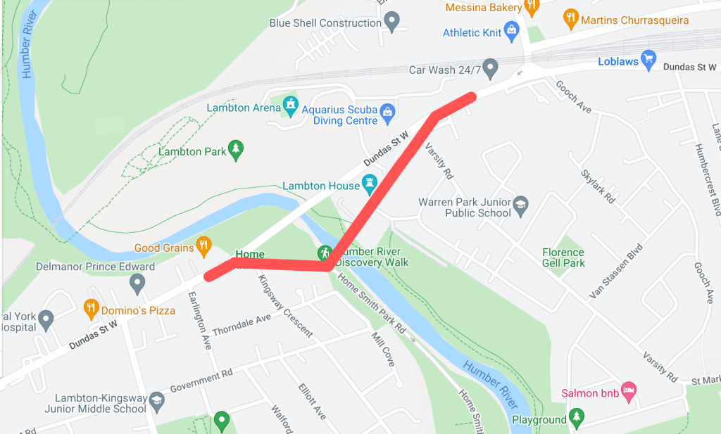
Historically, the main crossing over the Humber River on Dundas Street was located about two hundred metres south of the current bridge. This section of Dundas made up the old community of Lambton Mills and served as a main entrance into Toronto from the west on the Dundas highway. There were several versions of Dundas Street bridges here over the years — some made of wood, some iron, but all narrow for traffic and susceptible to the flooding waters of the Humber.
1924 Goads Fire Insurance Map of old course of Dundas Street. Source: Goad’s Toronto
In 1929, a new high-level bridge was completed over the Humber. This altered the main course of Dundas Street to the north. The old course became “Old Dundas Street”. For nearly thirty years, the two Dundas Street bridges existed alongside each other. In 1954, the devastating effects of Hurricane Hazel left the Old Dundas Street bridge in a dilapidated state; it was finally demolished several years later. Today, Old Dundas Street exists on both sides of the Humber River mostly as a quiet residential street. Lambton House, a historic inn turned museum, is a leftover of Old Dundas Street and Lambton Mills’ prominence.
“A New High-Level Bridge”, The Globe, January 16, 1929. Source: Globe and Mail Archives.1950 Aerial Image of Dundas Street and Old Dundas Street. Source: City of Toronto ArchivesOld Dundas Street, 2021. Source: Google Maps
Old Weston Road
Year rerouted: ~1948
Weston Road takes an interesting route through northwest Toronto, running diagonally through its street grid from the historic town of Weston (makes sense, eh?) and creating some unconventional intersections. North of St. Clair Avenue, the route of Weston Road was historically located east of the present road on the other side of the train tracks. It made up the historic village of Carlton with St. Clair and Weston as its nexus. It is highlighted by the still standing, yet altered Heydon House Hotel, built 1890. Weston then ran south to join with Dundas Street.
1851 JO Browne Map of Toronto showing Weston Road and the village of Carlton. Source: Old Toronto Map1927 Heydon House. Source: City of Toronto Archives
Around the 1890s, another “branch” of the street was built north from Keele Street running parallel to the railway on its west side. This street took on the name “Weston Road South”. In the 1910s, the street was completed to join with the main Weston Road.
1908 Map of Toronto showing Weston Road. Source: Old Toronto Maps1909 Map of Toronto showing Weston Road. Source: McMaster University1910 Old Weston Road bridge over C.P.R. Source: City of Toronto Archives
Perhaps because Weston Road South offered a more direct route south into the city, it formally became the more prominent road in the 1940s. First, an “Old Weston Road” began to refer to the section of Weston Road between the railway and Hillary Avenue. This meant that at one time a person could stand at the intersection of Weston Road, Old Weston Road, and Weston Road South. In 1948, Weston Road South became just Weston Road. Also, the entirety of the older eastern section of Weston Road was renamed Old Weston Road, save for the section between the tracks and Hillary which was added to Rogers Road. As the tracks to the south grew, the section of Old Weston near Dundas became severed from the rest of the road. Today, Old Weston Road is a mostly residential street.
1945 Map of Toronto showing Weston Road. Source: Old Toronto Maps1948 Toronto Transit Commission Map showing Weston Road. Source: University of Toronto Map & Data Library.1951 Map of Toronto showing Weston Road. Source: University of Toronto Map & Data Library.
Old Eglinton Avenue
Year rerouted: ~1957
For an east-west street that has become so vital to Toronto’s street grid and home to many neighbourhoods, it is difficult to imagine that Eglinton Avenue did not always exist in one harmonious stretch of road. However, it took some doing to make it into the street of today. Until the 1950s in the eastern half of Toronto, Eglinton Avenue terminated near Brentcliffe Road in Leaside and did not resume again until Victoria Park Avenue in Scarborough. The area in between them was about a five-kilometre stretch of farmland and two ravines — that is, both the east and west branches of the Don River. In the mid-1950s, a massive project was undertaken to join the two sections.
1950 Aerial Image of the future location of the Eglinton Avenue East extension. Source: City of Toronto Archives1953 Map of Metropolitan Toronto. Source: York University Archives 1954 Aerial Image of the future location of the Eglinton Avenue East extension. Source: University of Toronto Map and Data Library
While an “Old Eglinton Avenue” seems to come out of the events of the 1950s, it seems a little unclear why. The street runs parallel to the “new” road for about half a kilometre west from Bermondsey Road. Like the surrounding area, it mostly houses industrial buildings. As Eglinton did not seem to exist between Leaside and Scarborough (at least not in any formal sense), the story of Old Eglinton is a bit of a mystery. Hiking The GTA has located an old roadbed for an “Old Eglinton Road“. This may have been a farm road or a line that divided farm lots. It is also notable how Old Eglinton Avenue aligns with a “pencilled in” Eglinton Avenue between Victoria Park and Leaside, so a theory may lay in that idea.
Extension of Eglinton Avenue east across the West Don River, 1955. Source: City of Toronto ArchivesOld Eglinton Avenue, 2020. Source: Google Maps
Old York Mills Road
Year rerouted: ~1972
The valley near Hogg’s Hollow has proven to be an obstacle to road transportation several times in its history. As I previously noted, Yonge Street was realigned in 1835 after skirting east to better tackle the West Don ravine’s topography. Because of this same geography, Wilson Avenue terminated at Mason Boulevard, meaning there was no direct east-west crossing at Yonge Street as we know it today. In 1972, a project was undertaken to extend Wilson to meet with Yonge and York Mills Road.
1971 Aerial Image of York Mills Road and Wilson Avenue. Source: City of Toronto Archives“Extension of Wilson Avenue”, Toronto Star, May 28, 1972. Source: Toronto Star Archives
To make this extension happen, a curved road was constructed from Wilson Avenue which then crossed Yonge Street and joined York Mills Road between Campbell Crescent and York Ridge Road. This meant the straight section of York Mills near Yonge Street was effectively separated from the main route, becoming “Old York Mills Road”. Today, Old York Mills houses a trailhead, a passenger pickup zone for York Mills Station, a condominium, and a church.
Old York Mills Road and Wilson Avenue Extension, 1973. Source: City of Toronto Archives.
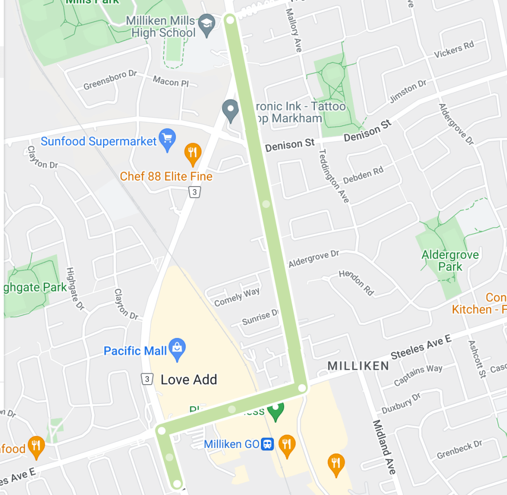
Old Kennedy Road
Year rerouted: ~1987
Kennedy Road just north of Toronto is a prime example of how of a noticeable curve in a street sometimes denotes a street was re-engineered. Kennedy existed in two separate sections north and south of Steeles Avenue, the Scarborough-Markham town line. The roads were about six hundred metres apart, meaning a northbound traveller from Scarborough had to jog east and then north again to continue into Markham. The area as a whole is and was known as Milliken, a historic community with the uncommon characteristic of existing within both municipalities.
1954 Aerial Image of Kennedy Road. Source: University of Toronto Map & Data Library
In 1987, the two sections of Kennedy Road were connected by a curving road running north from Steeles which veered east to meet the Markham section of Kennedy just north of the newly created Denison Street. The circumstances behind the re-alignment were unclear, but given Kennedy Road’s history as a ‘highway’ in Scarborough and the tendency in and around Toronto to harmonize streets within bordering jurisdictions, it is easily conceived why the jog was removed.
1987 Aerial Image of Kennedy Road. Source: City of Toronto Archives.
The eastern section of Kennedy became “orphaned” and was renamed Old Kennedy. Old Kennedy stops at Denison and continues on as Fresno Court, which in turn ends at a cul de sac. A fence separates it and Kennedy Road. Old Kennedy Road is an interesting mix of industrial and residential, with several older-looking houses near Steeles, perhaps lending back to the days when it was a hub in the village of Milliken.
Fresno Court, 2020. Source: Google Maps
Old Finch Avenue
Year rerouted: ~1993
Finch Avenue in Scarborough is relatively straight for much of its course from the North York town line to the Pickering town line — except in its most eastern part. Where Finch passed through Staines Road, the street at one time did a triangular job around the CPR tracks (the detour seems to have been created in the 20th century).
1916 Map of Townships, York, Scarboro, and Etobicoke. Source: University of Toronto Map & Data Library1954 Aerial Map Showing Finch Avenue. Source: Source: University of Toronto Map & Data Library
Further along, Finch did another jog up Sewell’s Road before meandering across the Rouge River and around its valley. It continued straight toward Kirkham’s Road (today’s Meadowvale Road). As there is today, there was an uncleared section of land across to Beare Road, thus one would have to jog up again to Plug Hat Road and back down to reach Finch again. The street resumed once more on its way to the Pickering Border. This stretch of Finch between Sewells and Kirkham’s made up the historic community of Hillside which had a church, school, and mill. The village made up much of the Rouge lands today from Sheppard Avenue/Twyn Rivers to Steeles Avenue.
1965 Aerial Image of Finch Avenue. Source: City of Toronto Archives.1969 City of Toronto Directory showing Finch Avenue. Source: Toronto Public Library
By the 1980s, changes came to Finch Avenue. Morningside Avenue curved from the south to meet Finch. Then, in or around 1993, the street was extended further north of Finch. This changed the alignment of the Finch/Staines intersection and effectively split Finch Avenue. Travellers moving east on Finch had to now follow the curving street north to Morningside Avenue and then curve back south via the same street. The east-west street on the other side was “Old Finch Avenue”, following the older, winding alignment. Because of this, the street bunks the trend of “old” streets which were leftover sections of the re-routed street; there is/was not ever a “newer” Finch Avenue that existed alongside the street. Old Finch terminates at Meadowvale Avenue; after Beare Road, it becomes Finch again and continues into Pickering for another eight kilometres.
“New Metropolitan Toronto Zoo Site”, Toronto Star, June 17, 1972. Source: Toronto Star Archives“Star Trek Run” Toronto Star, June 3, 1978. Source: Toronto Star Archives1983 Aerial Image of Finch Avenue. Source: City of Toronto Archives
Today, Old Finch is mostly known for its ‘haunted’ Bailey bridge and being the northern border of the Toronto Zoo, whose postal address is 361A Old Finch Avenue. The reconfiguration at Staines also facilitated the Morningside Heights neighbourhood.
“Grand Opening”, Globe and Mail, May 20, 1993. Source: City of Toronto Archives
2022 Finch Avenue. Source: Google Maps
The Older Finch Avenue
Year rerouted: 1977
Old Finch Avenue in the Rouge Valley was not the first Old Finch in the city. There was once a severed section of the street near Victoria Park in the old community of L’Amoreaux when the street was realigned directly across the Scarborough-North York border. This curved realignment eliminated a jog along the town line for east-west travellers. This Old Finch Avenue was closed in 1977; Pawnee Avenue roughly follows its old right of way.
1975 Aerial Image of Victoria Park and Finch Avenue Source: City of Toronto Archives
“Borough of North York Notice of Road Closing”, The Globe and Mail, September 9, 1977. Source: The Globe and Mail Archives
For a Google map of “Old” Toronto Streets, click here.
Map of “Old” Toronto Streets. Source: Google Maps Created by: Bob Georgiou
If you have any information to add or have any stories from any of these locations, leave a comment below or email bob@scenesto.com!
Toronto’s street grid is over 200 years old by colonial standards and even older with its Aboriginal trails. There have been additions and extensions, widenings and improvements. They have also been named to reflect the city’s past and present and it values (by those who do the naming, that is) – and to help the postal service.
The city is not a static object and neither are street names. Revisions and renamings have been an understated part of Toronto’s history. However, not all street renamings — proposed and actual — have gone over well. What is the mainly reason for this opposition? Simply put: History and Tradition. Whether successful or not, these episodes in Toronto’s history inform us how the city operated and why Toronto’s geography is as it is today.
Here are seven examples of controversial street name changes:
Old and New St. Patrick Street
In 1917, modern Dundas Street was created by amalgamating and connecting several smaller streets. One of these roads was St. Patrick Street, which ran between McCaul Street and Bathurst Street.
St. Patrick Street looking west to Spadina Avenue, circa 1911. Source: City of Toronto Archives 1913 Goad’s Fire Insurance Map. Source: Goad’s Toronto
One group opposed to changing St. Patrick to Dundas was the St. Patrick’s Old Boys’ Association, which attended the old St. Patrick’s School on William Street. The group deputed to City Council, but was unsuccessful. The story was not all bad as William Street was later renamed to St. Patrick Street to keep the tradition.
Dundas Street, looking east towards McCaul Street (home of St. Patrick’s Church with the new St. Patrick’s Street behind it), 2021. Source: Google Maps
Mimico Mixups
In 1929, a dispute over the renaming of 54 Mimico streets spanned several council meetings. At issue, Toronto’s postal service requested the changes after Mimico and Long Branch were placed in the Toronto postal region. The difficulty was the added municipalities added duplicate street names to the region and potential confusion for postal workers. An ex-mayor attended a September 1929 council meeting arguing why the inclusion of ‘Mimico’ in the mailing addresses would not be sufficient enough for postal workers. Matters got heated in an October meeting when Mimico Mayor and Liberal candidate W.A. Edwards accused Minister of Health and Conservative candidate Dr. Godfrey of “insincerity” when Dr. Godfrey opposed the name changes when the mayor rejected Dr. Godfrey’s wish to have Stanley Avenue changed to Godfrey Crescent.
1924 Goad’s Fire Insurance Map Source: Goad’s Toronto
It is unclear whether the by-law change went through, but in the October council meeting, it was moved and seconded that a second reading for the proposed by-law change be conducted. The Mimico street grid remains generally intact since the 1920s, albeit with notable changes: Church Street is now Royal York Road, Salisbury Avenue is now Park Lawn Road, Brant Street is now Dalesford Avenue, and Winslow Avenue is now Douglas Avenue.
Mimico, 2021. Source: Google Maps
Long Branch Street Changes & Disappearances
In 1952, a ratepayers association in Etobicoke protested the changing of part of Lake Promenade Road to Island Road in Long Branch. Lake Promenade existed in two sections on either side of the main branch of Etobicoke Creek, running all the way to Applewood Creek. To eliminate confusion for postal workers, it was proposed for the western section of Lake Promenade be added to Island Rd, which it already connected to.
1953 Aerial Image Source: City of Toronto Archives
Residents of Island Road did not like the idea as a recent storm severely damaged and condemned several homes on Lake Promenade and the association with that event to their properties was unwanted. The change ultimately took place by 1955, although it ultimately did not matter as the fallout of Hurricane Hazel caused the expropriation of homes on Island and Lake Promenade near Lake Ontario and Etobicoke Creek, as well as the complete removal of Lake Promenade west of Forty Second Street, James Street west of Forty Second Street, all of Forty Third Street, and Island Road parellel to the lake. Today, much of the area is parkland.
2022 Aerial Image. Source: Google Maps
The Pioneers of Scarborough
In 1957, Scarborough Council was tasked with submitting a list of alternate names for 210 streets duplicated elsewhere in the City. Metropolitan Toronto was standardizing operations and services across the city in the decade, including eliminating duplicates of street names.
1957 Map of Metropolitan Toronto Source: University of Toronto Map & Data Library
Confusion over postal delivery was again at issue, but names on the list included Brumwell St, Cornell Avenue, Harris Avenue, Kennedy Road, Little’s Road, Lennox Avenue, Muir Drive, and Paterson Avenue — streets named for Scarborough pioneers. Most streets seem to exist today, save for Lennox Avenue and Agincourt’s Paterson Avenue, which became Reidmount Avenue.
Kennedy Road, looking south to Reidmount Avenue (which amalgamated with the former Paterson Avenue), 2021. Source: Google Map
The Many Orioles
In 1958, duplication was at issue again in midtown Toronto with a proposal to rename the similarly named Oriole Crescent, Oriole Gardens, and Oriole Road. The names were to become Holmfield Crescent, Lower Canada Gardens, and Campus College Road, respectively.
1957 Map of Metropolitan Toronto. Source: University of Toronto Map & Data Library
Fifteen “angry” women of the three streets united to protest the move, even going as far as saying they’d be willing to go to jail for taking down the new signs if they ever went up. They cited the beauty, history, and fame of the “Oriole” name and the inconvenience it’d cause for people living on those streets to having to change addresses on documents. Ultimately, the names remained as they were and as they are today.
Looking east down Oriole Gardens at Oriole Road, 2021. Source: Google Maps.
A Mega-Maxome Avenue
In 1962, Willowdale residents protested the renaming and merger of Halstead and Maxome Avenue to Harkness Street. The three streets were disjointed and together would “form a mile long thoroughfare north of Finch Avenue.”
1955 Map of Metropolitan Toronto. Source: University of Toronto Map & Date Library
A resident of Maxome, representing 37 others on the street, argued the historical naming of the street, which was honouring a surveyor who laid out the original blocks of the area. Ultimately, the proposal did not go through. Curiously, Halstead and Harkness have disappeared from the map, having the name Maxome Avenue instead. Today, Maxome has a windy course, like it was strung together from a few different streets, creating a mega-street of sorts.
Maxome Avenue, 2021. Source: Google Maps.
North York Pioneers
In 1979, Scrace Hill Drive in North York was renamed to Skymark Drive, prompting the opposition of the Scrace family. The Scarces had historical roots in the Finch Avenue and Leslie Street area formerly known as L’Amoreaux, donating land for a church and cemetery, still standing today as Zion Church.
1916 Map of The Townships, York, Scarborough, and Etobicoke. Source: University of Toronto Map & Data Library
The family wrote North York Council a letter, outlining the connection and how several Scraces were even on North York Council. The street was renamed to Skymark after the development on the street, as the old street had a confusing spelling and was not easy to find. North York Controller Esther Shiner said the new name was “such a pretty name” and she would find something else to name after the Scraces. Of irony, Esther Shiner would later become the subject of a street herself.
Skymark Drive, 2021. The Skymark Towers are behind the shot. Zion Methodist Church is on the left. Source: Google Maps.
Sources Cited
“Citizens Protest Against Change In Street Name.” The Globe, 9 Oct. 1952, p. 12.
“’Godfrey Crescent’ Causes Verbal Tilt At Mimico Council.” The Globe, 15 Oct. 1929, p. 16.
“Keep Traditions: Opposes Renaming Traditions.” The Globe, 6 Mar. 1957, p. 4.
“Petty Politics Involved In Changing Street Names.” The Toronto Daily Star, 15 Oct. 1929, p. 5.
“Sees Lakeshore Trustees ‘Trying to Hoodwink Us’.” The Toronto Daily Star, 9 Oct. 1952, p. 26.
“St. Patrick Old Boys Form Strong Body.” The Globe, 7 Apr. 1917, p. 21.
“Street Name Change Bruises Family Pride.” The Globe and Mail, 10 Dec. 1979, p. 4.
“Street Name Change Fought By Residents.” The Globe, 8 Feb. 1962, p. 4.
“Would Go To Jail: 15 Angry Women Save Their Street Names.” The Globe, 5 June 1958, p. 23.
In the first half of the twentieth century, automobiles had quite an impact on the streets of Toronto. In 1913, there were 17,000 cars in Toronto; by 1923, the number grew to about 50,000 cars. New rules and technologies were adopted to better manage and regulate how motorists behaved, especially concerning the other users of the road and their safety.
Traffic conditions, Adelaide and Bay, 12:10, (Executive Department), 1927. Source: City of Toronto Archives
Traffic Lights: A Most Beneficial System
On August 8, 1925, Torontonians were introduced to their first set of automated traffic signals. The new ‘semaphores’ were set up at the busy intersection of Yonge Street and Bloor Street on a trial basis and changed the history of Toronto’s streets forever. It was at least three years in the making, with Toronto Chief of Police Samuel J. Dickson advocating for and finally receiving the system in that time.
“Traffic Control by Lighting System” The Toronto Daily Star, August 8, 1925. Source: Toronto Star Archives
“Traffic Control by Lighting System” The Toronto Daily Star, August 8, 1925. Source: Toronto Star Archives
Before traffic lights, intersections were regulated by traffic policemen. In the 1910s, this was done largely through hand signals, whistles, and yelling. In 1920, a new ‘semaphore’ was piloted (again at Yonge and Bloor) which consisted of the officer controlling a staffed sign with the words “STOP” and “GO” written on them. The officer rotated the sign to control the flow of traffic. If one peruses archival photos of highly trafficked Toronto intersections, it is common to see a police officer amid the action.
Southwest corner of Yonge and Bloor streets, 1923. Source: City of Toronto Archives.
“Semaphore on Trial”, The Toronto Daily Star, June 6, 1920. Source: Toronto Star Archives.
The new traffic lights were an overall success. Automated signals were installed on major junctions along Yonge Street, Bloor Street, and Danforth Avenue, and in suburbs such as East York within the next few years after their introduction. As an example of the new semaphores’ impact, The Globe reported in December 1929, the intersection of Bloor Street and Keele Street had an average of 4 or 5 accidents a day before automated signals were installed there in 1927; there were no accidents after that point.
Police Chief Dickson even dreamed of a master tower at Yonge and Queen to control all the lights in the city. The idea became a reality at the end of 1926. There was even synchronicity within the lights: a motorist travelling straight on Danforth Avenue between Main Street and Broadview Avenue in 1928 was able to meet all green lights if he travelled at 19 or 20 miles per hour; any slower or faster, the driver would hit a red light (the speed was 18 miles per hour downtown).
Automatic traffic signal, King and Yonge, 1927. Traffic Lights were switched to a vertical orientation and a yellow/amber ‘warning’ light was formalized several years after 1925. Source: City of Toronto Archives.
Of course, several early reports indicated that the new lights were not all good. Even the Mayor weighed in, saying to the Police Chief in October 1925 that officers were still stationed at the Yonge and Bloor ‘experiment’, seemingly defeating the Chief’s goal of having the technology free up more policemen from traffic duty. Sometimes they did not function properly or at all, as The Globe reported in July 1928 of the new, often “stuck” Dundas Street East signals. But despite these complaints, the lights were there to stay; 96 signals were installed in Toronto by the end of the 1920s.
Queen and Yonge, looking west, traffic, noon – 1 p.m., (Executive Department), 1929. Despite the functioning green light, an officer monitors the traffic. Source: City of Toronto Archives
Bloor and Yonge streets, southwest corner, 1928. One compare the crossing to the earlier 1923 image. Source: City of Toronto Archives
The ‘Right on Red’ Rule
One of the most interesting impacts of the rise and success of traffic lights was a ‘new’ law that permitted a motorist to make a right-hand turn against a signal that would otherwise make him wait at the intersection. This is the ‘right on red’ rule. On March 22, 1927, Police Chief Dickson announced the reinstatement of the permission, indicating that it was actually in effect “some time ago” and the success of the new lights could now allow for it once more. It is unclear what period the rule was previously in place or why it disappeared, although reckless driving at unmanned intersections is a theory for its removal.
Corner of King and Yonge streets, 1910. Note the right-turning vehicle. Source: City of Toronto Archives
The ‘right on red’ permission was not without controversy, even with the police itself. The organization vowed to watch right-turning drivers and warned them to prioritize the safety of pedestrians who had the right of way to cross the street.
In July 1928, new Police Chief D.C. Draper reiterated motorists were allowed to turn right at a “hostile” light, having “regard” of other cars and pedestrians who have the right of way. However, in March 1929, Draper advocated against the rule. In a report by the Traffic Committee, which monitored Toronto streets for more than a month for traffic improvements, the Chief suggested, among other items, the discontinuance of “the present practice of motorists making a right-hand turn against the red light” or “otherwise give them a warning that the pedestrians have the right of way, and that right-hand turns against a red signal are only allowed when care is exercised”. The Board of Control ultimately went against the Chief and retained the rule while reiterated motorists were responsible for pedestrian safety.
King and Yonge streets, northwest corner, looking west, 1912. Source: City of Toronto Archives
Interestingly, in Hamilton, which was the setting of Canada’s first traffic lights just two months before Toronto’s semaphores were installed, the Traffic Committee wanted to abolish the rule which allowed right-hand turns on red lights in 1933. Oddly, it was met with disapproval from the Ontario Department of Highways. The by-law ultimately remained.
Despite many calls in Toronto in the decades since to remove the permission for good, the Highway Traffic Act currently upholds it in Ontario:
s. 144 (19) Despite subsection (18) and subject to subsection (14) [Green Arrows], a driver, after stopping his or her vehicle and yielding the right of way to traffic lawfully approaching so closely that to proceed would constitute an immediate hazard, may,
(a) turn to the right; or
(b) turn to the left from a one-way street into a one-way street,
without a green indication being shown.
Traffic conditions, Adelaide and Bay, 1210, (Executive Department), 1927. Note the traffic light and police officer on horseback. Source: City of Toronto Archives
To Stop or Not?
Another interesting question arose on the requirement to stop before turning right. In November 1927, a person writing into The Toronto Daily Star‘s “Voice of The People” section was puzzled by the different standards of when there was a stop sign at an intersection (which he interpreted as ‘stop means stop’) and when there was a policeman with a semaphore (which he interpreted as ‘stop means stop sometimes‘). The editor replied that when an officer was holding the semaphore, he supervises traffic and allows right turns without stopping. When there is no officer, all cars must stop.
Southeast corner of Bloor and Yonge streets (Imperial Bank of Canada), 1924. Source: City of Toronto Archives
Within Toronto City Hall, the issue of drivers legally passing through a red light to turn right was debated for several years. In July 1929, Toronto’s Traffic Committee suggested an amendment of certain by-laws to protect pedestrians, including motorists were to come to a stop before making a right-hand turn against the red light. It did not seem to have made an impact. In December 1933, the idea was raised again, this time proving more successful. The Board of Control favoured a change to the by-law so that every driver must come to a full stop before making a right turn at an intersection controlled by automatic traffic signals. The change seemed to be spurred by complaints that motorists were not heeding the way to pedestrians and “showing no consideration for the pedestrian”. City Council adopted the change on December 12th of the year, subject to approval by the Department of Highways.
“City of Toronto Traffice By-Laws”, The Toronto Daily Star, March 2, 1933. Source: Toronto Star Archives
Inexplicably, the rule was changed back only four months later. In April 1934, the by-law requiring motorists to make a complete stop before a right turn at a red light was rescinded. The Board of Police Commissioners instructed police officers to safeguard the rights of pedestrians once more.
It is unclear when exactly the law reverted once again, but it seems the matter was not closed. The idea seemed to be backed in other circles, too. In a February 1934 meeting of the Ontario Motor League, a suggestion was advanced that those turning right in the province should come to a full stop at both a red land green light. In 1938, a reader of The Globe and Mail expressed his displeasure in the lack of pedestrian rights in motorists not having to stop before right turns. A decade later, in July 1948, the same newspaper rode along with Toronto Traffic Safety Council Inspector Vernon H. Page in a motor car as he pointed out traffic infractions, including those failing to come to a full stop before a right turn, meaning by this point the law was reinstated.
“Camera Catches Motorists, Pedestrians Breaking Rules”, The Globe and Mail, July 20, 1948. Source: Globe and Mail Archives
Today, of course, a red light does indeed mean ‘stop’ in all contexts, as the Highway Traffic Act so states:
s. 144 (18) Every driver approaching a traffic control signal showing a circular red indication and facing the indication shall stop his or her vehicle and shall not proceed until a green indication is shown.
Yonge Street and Queen Street, southeast corner, 1915. Source: City of Toronto Archives
Works Referenced
“24-Hour Operation Of Traffic Signals Proves Successful.” The Globe, 28 July 1928, p. 13.
“24-Hour Police Service, East York, Authorized; Other Changes Urged.” The Globe, 18 Jan. 1929, p. 13.
“Allow Right Turn Against Red Light.” The Toronto Daily Star, 22 Mar. 1927, p. 3.
“Automatic Control Of Central Traffic Assured InToronto.” The Globe, 20 Mar. 1926, p. 14.
“Automatic Control Of Toronto Traffic To Be Inaugurated.” The Globe, 5 Nov. 1926, p. 11.
“Automatic Signals To Be Installed At Fifty-Five More Intersections Controlling All Main Street Traffic.” The Globe, 10 Mar. 1928, p. 8.
“Automatic Signals Will Operate Today At Bloor And Yonge.” The Globe, 8 Aug. 1925, p. 13.
Across the map of Toronto, there are several “Old” versions of major streets: Old Yonge Street, Old Leslie Street, et cetera. These are smaller and certainly older streets that predate yet still exist alongside their longer, newer counterparts.
How old are these “old” streets anyways? Why were they built as they were in the first place? Why were they replaced?
Tremaine’s Map showing old courses of Toronto’s streets. Source: Old Toronto Maps
Here are five examples of “Old” Toronto Streets and their histories:
1. Old Yonge Street
Year rerouted: 1835
When Yonge Street was laid out in the 1790s, it was not the continuous straight path we think of today. The sheer length of the street almost welcomed obstacles. At York Mills, the challenging topography around the West Don River caused it to divert east just south of York Mills Road. It curved north and back west to join the original course. In 1835, the street was realigned and straightened. It seems in the 1920s, Yonge Street was re-routed again slightly to the west to allow for better automobile navigation.
1851 JO Browne Map of the Township of York. Source: Old Toronto Maps
1950 Aerial showing Old Yonge Street and “new” Yonge Street. Source: City of Toronto Archives.
“Yonge Street, at York Mills, Again Takes Altered Course” The Globe, February 26, 1921. Source: Globe & Mail Archives.
Today, the old, “orphaned” course remains as part of Mill Street and Old Yonge Street. Old Yonge’s narrow, curvy course in parts maintains a rural quality. While at one time Yonge and Old Yonge once connected at its north end, this connection is now a roundabout. Finally, because of its length in the province, there are other Old Yonge Streets in Thornhill and Aurora.
Old Yonge Street, 2021 Source: Google Maps
Yonge Street, 2021. Source: Google Maps.
Source: Google Maps & Bob Georgiou
2. Old Sheppard Avenue
Year rerouted: ~1934
Sheppard Avenue once existed in two separate sections on either side of the Scarborough-North York border. A traveller wishing to travel east or west through the two streets had to jog about 300 metres on Victoria Park to reach the other section. In 1934, the two roads were joined through a curving road running from just past Woodbine Avenue to the lower street in Scarborough. The move was the idea of Ontario Premier George S. Henry whose estate stood where the new Sheppard Avenue connection ran.
1965 Aerial showing Old Sheppard Avenue and “new” Sheppard Avenue. Source: City of Toronto Archives
Today, the orphaned North York section of the old road now exists as residential Old Sheppard, albeit with small parts removed around Highway 404.
Lawrence Avenue is and was one of many streets which was impact by Toronto’s ravines. West of Victoria Park Avenue, Lawrence once took an interesting route across the East Don River Valley. Like Sheppard Avenue, there were two sections of the street: the Scarborough section which exists today and a North York section. The North York section jogged up Victoria Park over the Canadian Pacific Railway, ran briefly next to the track, and continued west for 1.5 kilometres. From here, it took a rather curvy route south down the East Don Valley, crossed the Don River via a bridge, and curved back north and west before continuing towards Don Mills Road. Presumably, this was easiest way in the 19th century to navigate the valley.
1860 Tremaine’s Map showing Old Lawrence Avenue Source: Old Toronto Maps
Looking southwest at intersection of Victoria Park Avenue and Old Lawrence Avenue exit, 1958. Source: Toronto Public Library
1959 Aerial showing Old Lawrence Avenue Source: City of Toronto Archives
Lawrence Avenue E., bridge over East Don River, looking northwest,1955. Source: Toronto Public Library
In 1961, Lawrence Avenue was straightened with a road directly connecting Victoria Park and Woodcliff Place, curling northwest from Scarborough with several new bridges to accommodate the Don River and CPR.
1960 Aerial showing Old Lawrence Avenue and “new” Lawrence Avenue under construction. Source: City of Toronto Archives.
Lawrence Avenue East and CPR bridge under construction, circa 1960. Source: City of Toronto Archives.
Today, the orphaned old road exists as roughly as part of Roanoke Road and, more famously, a short access road to the East Don Trail named Old Lawrence. The remaining section west of the river along with the old bridge itself have been lost.
Like Lawrence Avenue, Leslie Street’s course at one time also had to divert around the East Don River. Also of 19th-century origin, a traveller going north on Leslie had to turn west for a short distance and then northwest for about 500 metres to meet with Sheppard Avenue. There was then a jog east on Sheppard, which included a bridge over the river and finally a left turn to travel north again.
1860 Tremaine’s Map showing Old Leslie Street. Source: Old Toronto Maps
1953 Aerial showing course of Old Leslie Street. Source: City of Toronto Archives
Sheppard Ave. East bridge near Leslie Street, 1964. Source: City of Toronto Archives.
In the 1950s, with the construction of Highway 401, Leslie Street was altered to curve through the highway, but the course has otherwise remained the same. In 1968, the street was reconfigured again to join with Sheppard more directly. The Don River was also straightened and a new bridge was constructed which spanned the entirety of the new four-way intersection.
1967 Aerial of “new” Leslie Street under construction. Source: City of Toronto Archives.
Today, the old course remains as Old Leslie Street, albeit a shorter version of the original route is available today to the public. It joins the new Leslie Street via Esther Shiner Drive. South of that street, there are City facilities. North of Esther Shiner, Old Leslie serves the Leslie Street TTC Station before it crosses over Sheppard via an overpass. It then curls back down to join the street (there is also a parking lot with an entrance to the East Don Parkland trail).
The original course of Cummer Avenue west of Leslie Street was an 1819 construction. The street was laid out as a side road from Yonge Street by the Cummer family to access their holdings (a mill and camp) near the East Don River. When it approached the valley, it curved down to roughly follow the river’s course. It crossed the river via a bridge and eventually the railway tracks at a level crossing. Finally, it terminated at Leslie Street.
1860 Tremaine’s Map showing Old Cummer Avenue Source: Old Toronto Maps
1968 Aerial showing course of Old Cummer Avenue. Source: City of Toronto Archives
By 1969, the street was rerouted to curve north away from the river (which looks to have been straightened around this time as well). The street passed through a new wider bridge over the Don River and then under a railway overpass before eventually becoming McNiccol Avenue at Leslie Street.
1969 Aerial showing “new” Cummer Avenue under construction and Old Cummer Avenue. Source: City of Toronto Archives
The old, orphaned course still exists in parts. The curved section lives on as part of the East Don Parkland trail, although not all of it follows the old path. The old bridge is in situ as well. The trail travels east through the hydro corridor where it terminates at the railway tracks. On the other side, Old Cummer Go Station and a hundred-metre long Old Cummer Avenue hold the old name.
In the compelling theme of ‘Lost Toronto’, the area bordered by Eastern Avenue, Cherry Street, the Don River, and Mill Street in the West Don Lands has had a transformative history. Two intersecting streets, Tate Street and Water Street, were at the figurative and geographic centre of this intriguing district.
Aerial, 2020. Source: Google Maps.
In his Landmarks, John Ross Robertson wrote Water Street was named after the Don River, which the street once ran along. Before 1876, Water Street was East Street after its location in the city of Toronto. In its longest version, Water Street ran from Eastern Avenue to the railway tracks. The street looks to date from the 1830s when the marshy area of the east end of Toronto was added to the street grid.
1833 Bonnycastle: No.1 Plan of the Town and Harbour of York Upper Canada. South is at the top of the map. Credit: Old Toronto Maps
Robertson wrote Tate Street was named after Mr Tate, the contractor for the Grand Trunk Railway (the right of way ran south of the street). In its longest version, Tate Street ran from Cherry Street to the Don River. Don Loucks and Leslie Valpy wrote in their Modest Hopes: Homes and Stories of Toronto’s Workers from the 1820s to 1920sthat Tate Street first appeared on maps in the 1850s.
1858 WS Boulton: Atlas of the City of Toronto and Vicinity. Source: Old Toronto Maps.
Several details are available about life on Tate and Water Streets. Loucks and Valpy describe the area around and including the streets as a “bustling neighbourhood, with rows and rows of workers’ cottages as well as large and small factories”. The detailed Fire Insurance Map of 1889 tells us these were mostly tiny, one-storey, wooden structures, some of which (mostly on Water Street) had rough cast or plastered finishes. It also shows a relatively populous district with several pockets of empty lots, notably on Water Street north of Front Street and the south side of Tate Street near Cherry Street.
1889 Insurance Plan of the City of Toronto. Source: Goads Toronto
The Toronto Directory for 1880 offers a snapshot into the working-class identity of Tate and Water Streets. Professions are listed as mostly labourers. This is not surprising considering the proximity of industries: Gooderham and Worts distillery to the west, the Toronto Rolling Mills (until 1914) and Grand Trunk Railroad to the south, and the William Davies Co. giant meatpacking operation to the east.
Toronto directory for 1880 Source: Toronto Public Library
Toronto Rolling Mills, Mill St., south side, between Cherry St. and Overend St. (at southwest corner of former Water St.); Interior, 1864. Source: Toronto Public Library
Front St. east of Overend St., 1925. Source: City of Toronto Archives. The William Davies Co. is on the right; a sign adorns the top.
At the close of the 19th century, several developments altered the course of history for Tate and Water. By the early 1890s, the Canadian Pacific Railway opened a branch through the east end of Toronto and up through the Don Valley. The track ran south of the western side of Tate Street, crossed Water Street at a level crossing, and then curved northeast adjacent to the Don.
1893 Barclay, Clark & Co. Bird’s Eye View. Source: Old Toronto Maps
In 1900, the William Davies Co. successfully applied for some changes to the street grid to accommodate an expansion:
The closure of Beachall Street from Front to Mill;
The closure of Tate Street from the west limit of Beachall Street to the east limit of Vine Street
The southern extension of Vine from Front to Mill
The eastern closure of Tate Street from the new Vine Street (which was later renamed to Overend) razed structures across nearly thirty lots on and around Tate.
1903 Toronto Fire Insurance Map. Source: Goads Toronto
In 1905, the Canadian Northern Ontario Railway acquired the lands east of Cherry Street between Eastern Avenue and Front Street. The company built freight yards on the property, which would later serve the Canadian National Railway from the 1910s onwards. Water Street lost about eighteen residences north of Front Street.
1913 Toronto Fire Insurance Map. Source: Goads Toronto
Archival images of the area are limited, but two images in 1907 offer a good insight into the physical look of the area. The photos look up and down Water Street from north and south of the CPR crossing and Tate Street. Most notable are the wet, muddy, wagon-tracked streets. Tate and Water, along with Mill, Cherry, and Overend Streets were not paved.
Water St., looking n. from s. of Tate St., across C.P.R. tracks & Tate St. to Eastern Ave. at head of street., 1907. Source: Toronto Public Library
1907 Water St., looking south from Tate St., across C.P.R. tracks to Mill St. Source: Toronto Public Library
The foot of Water Street had a row of houses (numbered 2 to 14) on the west side. The corner property was a grocery run by the McSherrys. The archives label these homes as “old”. While not condemned like others that are photographed, the age and condition of the structures likely made the area more primed for redevelopment.
Old houses ( front view ) – 2 to 14 Water Street, 1912. Source: City of Toronto ArchivesOld houses ( rear view ) – 2 to 14 Water Street, 1912. Source: City of Toronto Archives
Cherry St., looking s. from Tate St., across C.P.R. tracks towards Mill St., 1907. Source: Toronto Public Library
A few newspaper articles may have further pointed to the shabby nature of the residences. In 1904, a Mrs O’Brien was severely burned by an exploding lamp in her home at 12 Tate Street. In an odd tale from 1908, an 18-year old girl was turned away by her step-father and mother at 22 Tate Street after giving birth. The girl was taken in by a George Davis at 44 Tate Street where she slept downstairs in a low, mouldy room where water had been creeping in. Davis had four rooms in the house and he sublet two rooms to another family. While these events may have been one-offs or coincidental, they do fit the narrative of what was about to happen.
Old house – Mill Street opposite Water Street (161, vacant), 1912. Source: City of Toronto Archives Condemned houses- southwest corner Water Street and Eastern Avenue, 1917. Source: City of Toronto Archives
In 1911, The Canadian Pacific Railway expanded again. In April, the company served notice to all “tenants of the district bounded by Cherry, Water, Overend, Tate, and Front Streets to vacate their premises by the end of the month”. Freight yards and sheds were to go in their place. The Globe noted the properties occupying the area were “shacks” and would be torn down. Tenders to tear down or remove sixty houses were awarded by the company at the end of the month, although residents stayed until June.
“TENDERS ARE IN FOR CLEARING YARDS”, The Globe, April 29, 1911. Source: Globe & Mail Archives
“Fires From Crackers” Toronto Daily Star, May 25, 1911. Source: Toronto Star Archives
In May, the City granted permission to the CPR to close Tate and Water. The company had already acquired 90% of the property in the area. In June, there seemed to have been an impasse with Thomas O’Connor’s property. The CPR needed the property to build a railway viaduct. The company stated they would expropriate if no price was agreed and they differed on price. Loucks and Valpy wrote William O’Connor was a champion oarsman whose family moved to Tate Street in the 1860s; it is unclear if Thomas O’Connor was related, as the authors wrote the O’Connors left Tate Street in 1891. The final house on Tate Street was demolished in 1913. The streets continued to exist in the city directories and real-life, albeit as shortened versions of their former selves without anything except CPR and CNR structures built upon them.
1924 Toronto Fire Insurance Map. Source: Goads Toronto
Aerial, 1965. Source: Toronto Public Library.
Industry in the West Don Lands area continued for the next seventy years. In the 1990s, the former William Davies Co buildings along with the CPR and CNR tracks were gradually removed. A failed project in the 1990s entitled ‘Ataratiri’ aimed to redevelop the land for residential use, a goal which was eventually fulfilled by the Corktown Commons parkland and the rebranded Canary District in the 2010s.
Aerial, 1992. Source: Toronto Public Library
Ataratiri site plan, 1990. Source: City of Toronto Archives
Although Mill Street, Front Street, Cherry Street, and Eastern Avenue remain today and there is a new Rolling Mills Road, traces of Water Street and Tate Street and the bustling residential district once contained within them are essentially non-existent. Tannery Street roughly lays where Water Street once stood.