The Rise of The Hill District, Toronto

The Hill District in Toronto is a lost neighbourhood — well, somewhat. The name may not be in prominent use, but its geography is certainly still there. The events of the 19th century and early 20th century that led to the rise of this interesting district involve pre-historic escarpments, stately houses, prominent Torontonians, unbuilt plans, and more.

1950 Aerial view showing Casa Loma, looking north-east from south of Dupont Street
Source: City of Toronto Archives

The Beginnings

In rough terms, the Hill District can be found from Avenue Road to Bathurst Street and the Canadian Pacific Railway to north of St. Clair Avenue.

2022 Map of The Hill District
Source: Google Maps

The “Hill” is the Davenport Road Escarpment, a glacial leftover of the old Lake Iroquois. It is also called the “Davenport” Hill or the “Spadina” Hill – words with Indigenous connections and origins. Davenport was an old portage trail; its name in Ojibwe is Gete-Onigaming: “at the old portage”. Spadina is a transliteration of “Ishpadinaa” or “a place on a hill” (meaning Spadina Hill actually means “Place on a Hill-Hill”).

1876 Gross Bird’s Eye View of Toronto.
Source: Old Toronto Maps

In the 19th century, the area that would become The Hill District was mainly made up of grand, hundred-acre-and-more estates owned by prominent early Toronto settler families. These included the Baldwins, the Austins, the Wells, the Nordheimers, and more. By the turn of the century, the large, open estates began to turn to subdivided lots with the beginnings of a street grid.

1884 Fire Insurance Map
Source: Goad’s Toronto
1894 Wells, Joseph, house, north of Davenport Road, east of Bathurst Street, Toronto, Ontario.
Source: Toronto Public Library
1908 Entrance to Nordheimer estate (Glen Edyth).
Source: City of Toronto Archives

At this point, developers and newspapers began to formally refer to and market the area as the “Hill District” — “the finest and will be the most exclusive residential district”. Advertisements attracted potential buyers to areas such as College Heights near Bathurst between St. Clair and Eglinton, Dunvegan Heights on Forest Hill Road, and Walmer Hill and St. Clair Park, both adjoining upscale subdivisions northeast of Bathurst and St. Clair.

The Globe, October 30, 1911
Source: Globe and Mail Archives
Toronto Daily Star, May 17, 1912
Source: Toronto Star Archives
The Globe, May 24, 1913.
Source: Globe and Mail Archives

Coinciding with the growth of ‘The Hill District’, areas were annexed by the City of Toronto in the first decades of the 20th century. This included the annexation of Wychwood and Bracondale in 1909, which included parts of the Wells, Austin, and Nordheimer lands. Also included were areas north of St. Clair and south of Lonsdale Road, between Spadina Road and Avenue Road.

1967 Annexation Map of Toronto
Source: Old Toronto Maps

The Neighbours

There were three noted neighbours of the early Hill District. James Austin, founder of Dominion Bank, was the owner of ‘Spadina’, an estate purchased from the Baldwins in 1866. Austin built Spadina House, the third version of the Baldwin manor. It was the next generation of homes to experience the spectacular vista of Toronto from the hill.

1880 Austin, James, ‘Spadina’ (1866), Spadina Road, opposite Austin Terrace. Toronto, Ontario.
Source: Toronto Public Library

In the late 19th century, the western part of the Austin estate was subdivided into lots with laying out of Austin Terrace, Walmer Road, and Spadina Road.

1908 Map of Toronto and Suburbs.
Source: Old Toronto Maps

An interesting part of the Spadina story was the corridor leading from Davenport Road to Austin Terrace. Although the Baldwins laid out Spadina Avenue south to the lake, the right of way running north of Bloor faced the challenge of Davenport Escarpment. Here, a set of wooden steps was built in the place of a road. At the top, running adjacent to Spadina House and it gardens was a green right of way. In 1913, the wooden steps were replaced by a sturdier construction which offered a less steep climb. (They would be replaced again in the 1980s to give us the present Baldwin Steps).

Circa 1911 Old and new steps to Casa Loma from Davenport Road
Source: City of Toronto Archives
1913 Spadina Road Park — north from Davenport Road
Source: City of Toronto Archives
1913 Spadina Road Park — south from Austin Terrace.
Source: City of Toronto Archives

In the middle of the first decade of the 1900s, the very-interesting industrialist and land speculator Sir Henry Pellatt purchased property from the Austin and Wells estates for the construction of Casa Loma. The first structures completed were Pellatt Lodge and the horse stables on Walmer Road in 1905. His grand ‘castle’, which translated to ‘house of the hill”, was completed between 1911 and 1914.

1911 Casa Loma under construction
Source: City of Toronto Archives

An interesting episode in the construction of Casa Loma was Pellatt’s desire to expand his property at the expense of the Spadina Road steps and right of way. The Globe reported on Pellatt’s proposal:

The Works Committee of the City Council displayed gratuitous toleration of Sir Henry Pellatt’s ridiculous proposal to close Spadina road to Davenport road, and sell the right of way up the hill to enlarge the building site…

…It would be, were Davenport road widened, as it ought to be, comparatively easy to make a carriage road up to the hill…Perhaps the fear of the effect of such improment on his propety is the real motive for Sir Henry’s proposal. Whatever it is, he cannot have at any price what he is asking.”

The Globe, June 3, 1911.
1907 Spadina Road., looking south from north of Davenport Road.
Source: Toronto Public Library

More than the objection from the Works Committee, residents were also up in arms about the prospect of their direct access to the Dupont Streetcar being removed.

Sir John Craig Eaton was the son of Timothy Eaton, the famed department store baron. In 1908, Eaton purchased and razed the ‘Ravenswood’ house and estate, part of the Austin property, and constructed ‘Ardwold’, meaning “high green hill’, which was completed in 1911. Like Casa Loma and Spadina, Ardwold became the social hangout of ‘elite’ Toronto.

1922 Eaton, Sir John Craig, ‘Ardwold’, Davenport Road, north side, west of Huron Street
Source: Toronto Public Library
1915 Looking northwest from Casa Loma tower, with Spadina and Ardwold visible
Source: City of Toronto Archives

Eaton also funded and constructed Timothy Eaton Memorial Church on St. Clair Avenue near Dunvegan Road, opened in 1914.

1917 Timothy Eaton Memorial Church, Toronto, Canada
Source: Toronto Public Library

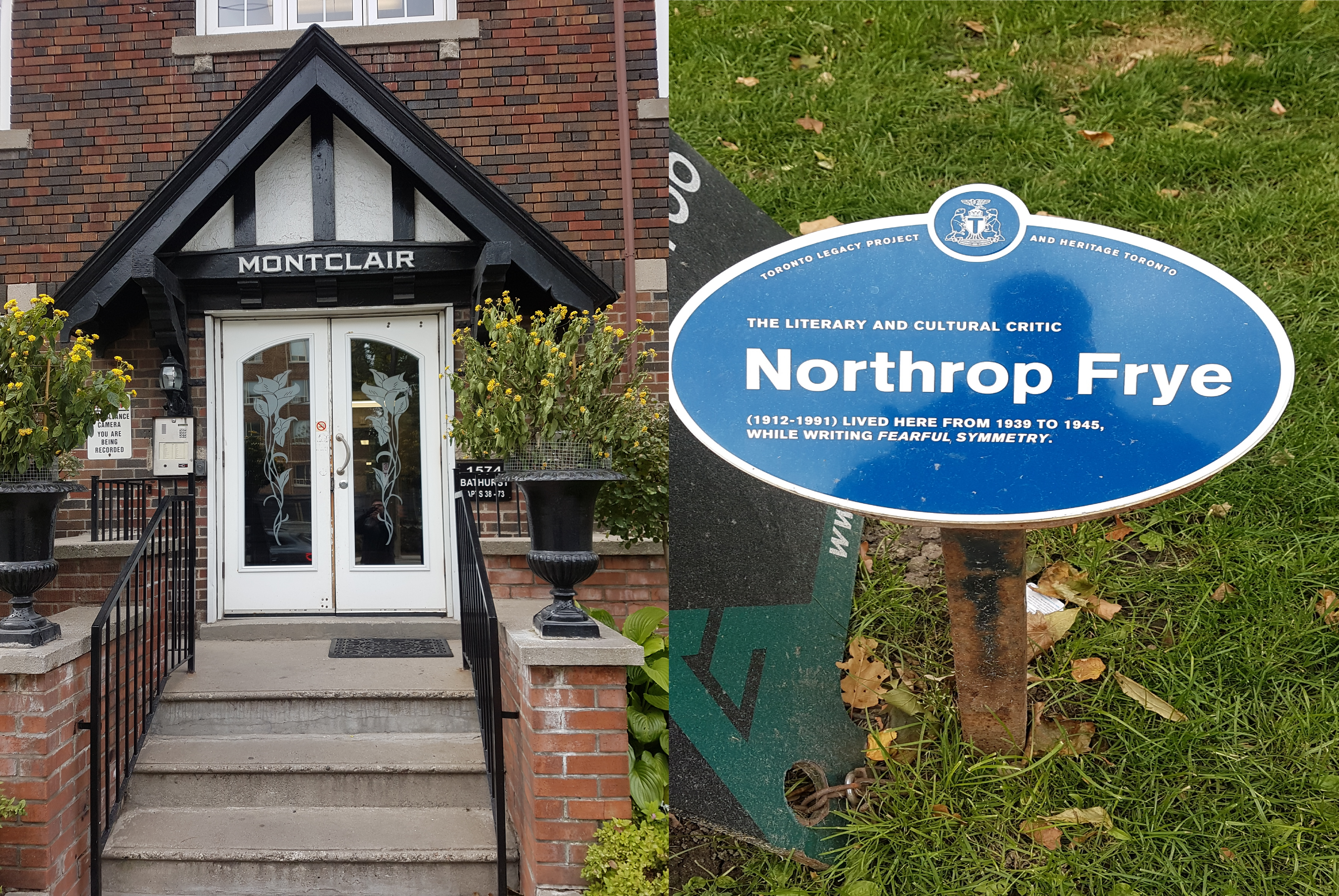
In 1916, Casa Loma Architect E.J. Lennox moved into ‘Lenwil’ at 5 Austin Terrace at Walmer Road, on 3 acres of land from the Wells Estate. Lennox previously lived on Sherbourne Street.

The Rise of The Hill

In the 1920s, The Hill District further filled out with stately residences, ornate apartments, grand churches, and new (and proposed) roads.

1913 & 1924 Fire Insurance Views of The Hill
Source: Goad’s Toronto

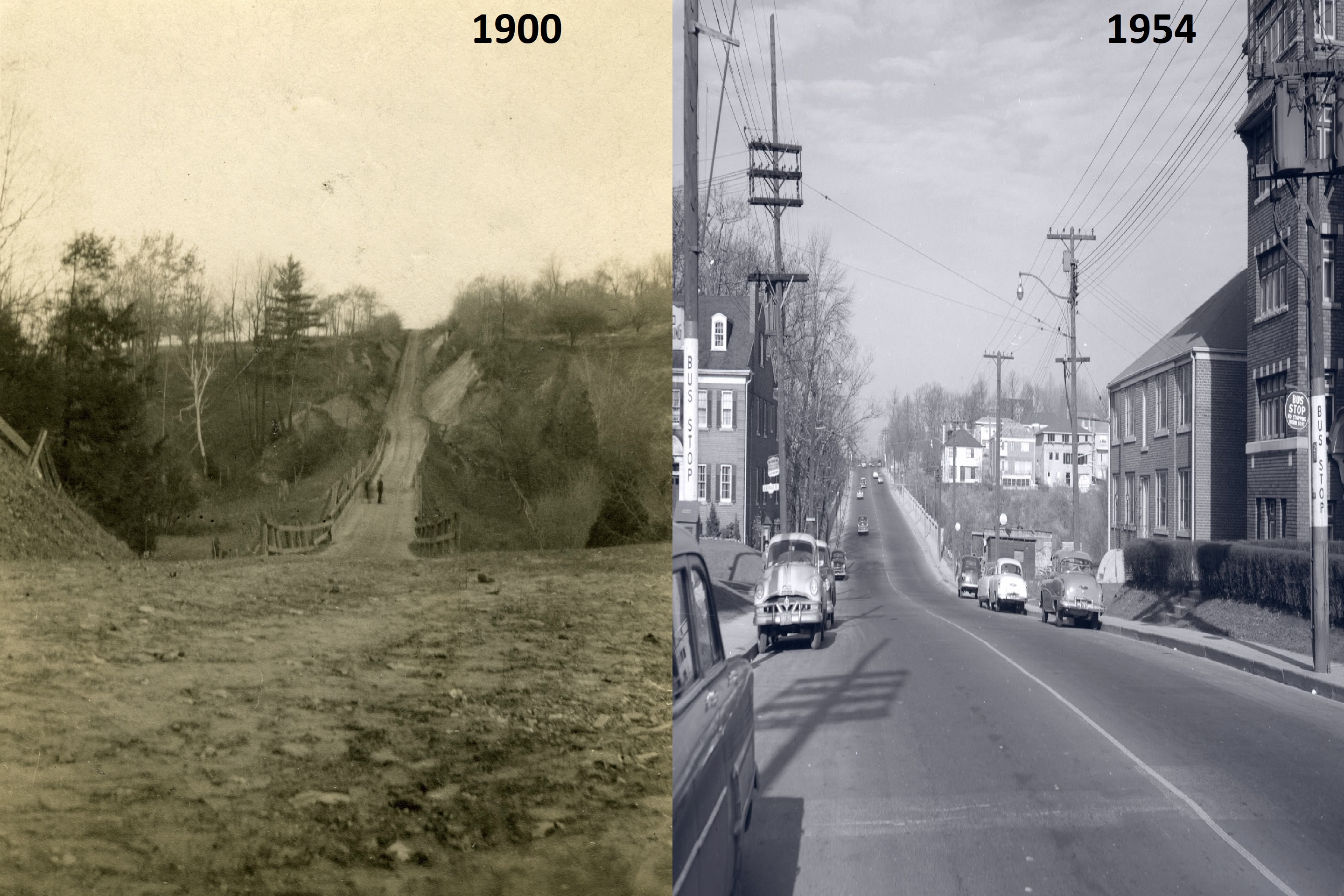
In 1925, the Toronto Transportation Commission began running a coach service to the Hill, running a bus from Bay & Albert Streets to the district via Poplar Plains Road and Warren Road to Lonsdale & Orioles Roads. It gave Hill residents an alternative to the St. Clair and Dupont cars.

1925 Transportation Map of Toronto
Source: City of Toronto Archives

As the Hill intensified, new roads were proposed. Many were built, but some remained as only plans. In 1912, the former Nordheimer estate lands were the site for a proposed alternate road to Poplar Plains Road. The new road would have ran northwest from Davenport and Dupont through part of the Austin and Eaton lands to meet with Spadina Road near St. Clair. It never materialized.

Toronto Daily Star, May 27, 1926
Source: Toronto Star Archives

In late 1920s, during the conceptualization of the St. Clair Reservoir to be located under the ravine, the idea of a highway through the lands resurfaced once more. While the reservoir was built along with a new bridge on Spadina Road, the road never materialized. (It would be another twenty years before another much more consequential highway project through Nordheimer Ravine — this one cutting through the valley west of Spadina and Road and down the street itself.)

1930 St Clair Reservoir & Spadina Road Bridge
Source: City of Toronto Archives

A particularly interesting project was the Peter Pan Statue in a parkette at Avenue Road and St. Clair Avenue. The College Heights Association funded the installation of the statue, which was a replica of the sculptor Sr. George Frampton’s work in Kensington Gardens in London. It was unveiled on the northwest corner of the intersection on September 14, 1929.

1929 Avenue Road Park – Peter Pan Monument
Source: City of Toronto Archives

Along with the Peter Pan Statue, a fountain was unveiled on the northeast corner. A donation by H.H. Williams, it too was a replica of a fountain found at the Peace Palace at The Hague.

1929 Fountain at northeast corner of Avenue Road and St. Clair Avenue
Source: City of Toronto Archives

The Neighbours, Revisited

The development and re-development of the area atop the Davenport Hill in the 1920s and 1930s featured some noteworthy episodes. In 1923, twelve plots opposite Casa Loma owned by the Pellatts were sold to a developer. These were four lots fronting onto Austin Terrace facing the castle and eight lots fronting onto Spadina Road and Walmer Road. In 1928, a plan was in place to build 26 semi-detached duplexes on the site. The caveat was the area required a zoning change, which was put to a vote:

Opposed were the following: R. A. Jones, K. M. Scott, F. E. McMulkin, Charles E. Walsh, W. C. R. Harris, Mary A. Rea, A. W. Austin, Mary R. Austin, Wm. A. Logie, Albert H. Austin, E. J. Lennox, C. W. Hookaway, Eleanor Guerney, H. L. Mathews, Helen McI. Kelley, Marjorie C. Pellatt, E. A. Bott, J. A. Rowland, Charles B. Boeckh, D. Macdonald; in favour, Lady Eaton and Eaton estate, H. J. Long, H. M. Pellatt, F. McMahon, and E. Renfrew.

Toronto Daily Star, May 19, 1928
The Globe March 7, 1923
Source: Globe and Mail Archives

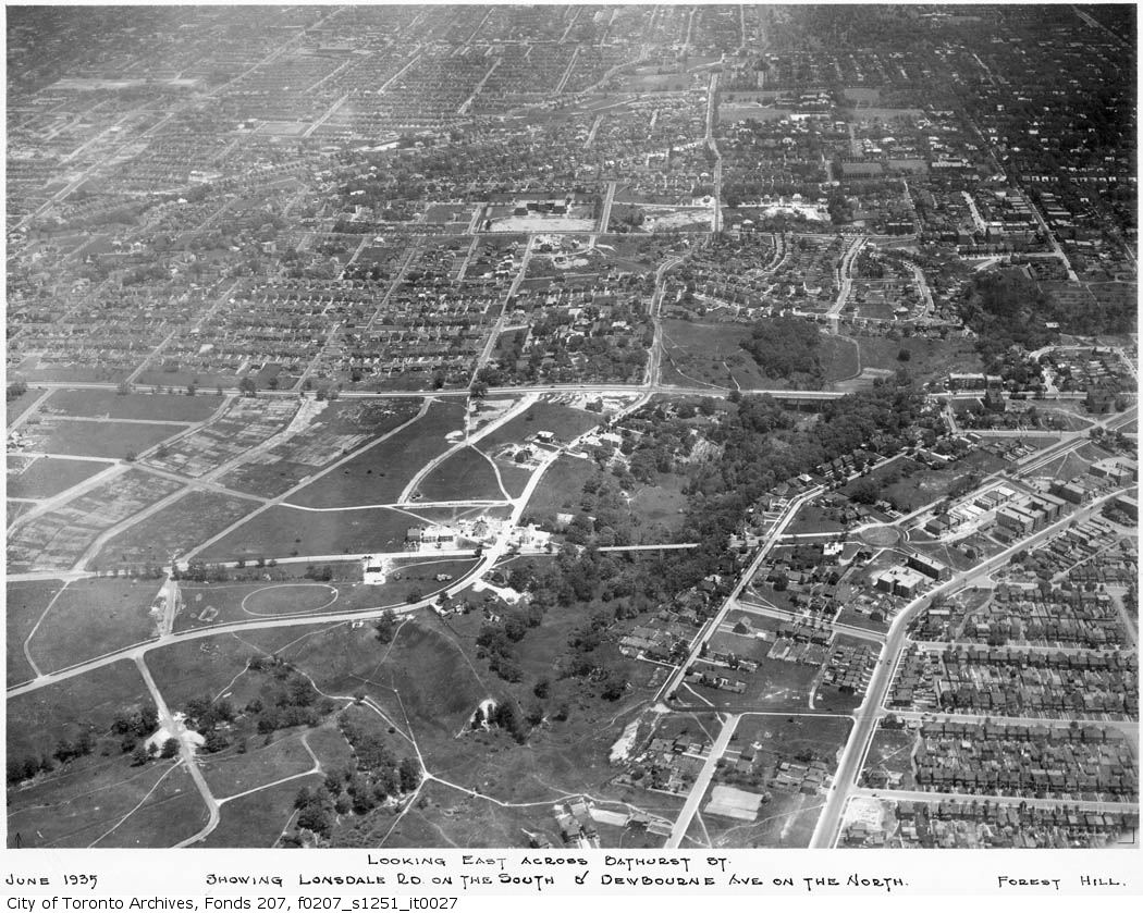
Although not constructed until 1939, the homes were ultimately built along with a new road — now the appropriately named Castle View Avenue — connecting Walmer and Spadina. An aerial look at the subdivision shows a distinct departure from the surrounding neighbourhood and how the historic properties line inform today’s environment.

The Globe, March 24, 1928.
Source: Globe and Mail Archives
1924 to 2022 Austin Terrace Duplexes
Source: Goad’s Toronto and Google Maps

The land to the west of Casa Loma directly north of the escarpment was also redeveloped. By 1910, Austin Terrace was extended to Wells Hill Avenue. Austin Terrace west of Walmer Road was renamed to Theodore Avenue, but then renamed again to Wells Hill Crescent in 1914. By the end of the decade, Austin Terrace was extended to Hilton Avenue near Bathurst Street. Hilton Avenue would be absorbed into Austin Terrace by 1926, completing a route from Spadina to Bathurst.

1924 to 2022 Austin Crescent and Lyndhurst Court
Source: Goads Toronto and Google Maps

Coincidentally, by 1923, the lot south of Austin Terrace and north of Davenport directly over the escarpment was bought for development. Austin Crescent was partially built to run south of Austin Terrace; it was later extended into the adjacent lot. Lyndhurst Court, the twinning cul-de-sac, was completed in the 1950s.

For the Eatons’ Ardwold, Sir John C. Eaton passed away in 1922. By 1936, his widow, Lady Flora Eaton, announced it no longer made sense to maintain the stately home as their children had grown up. The 11-acre was sold and subdivided into lots. The house was demolished, with its former site being located at the end of the cul de sac, Ardwold Gate.

Toronto Daily Star, February 12, 1937
Source: Toronto Star Archives

The Other ‘Hill District’

North of St. Clair, The Hill District had a neighbour in Spadina Heights. The area was known as such since 1910, when the area organized into York School Section 30. In 1923, after a failed bid for Toronto annexation, the area re-branded and incorporated as the Village of Forest Hill. It saw annexation finally in 1967.

The Hill District at one time may have actually included Forest Hill. But as The Hill District came to refer to areas annexed by the City of Toronto south of Lonsdale Road, the areas to the north came to be their own region.

1916 Map of Toronto, York, Scarboro, Etobicoke, showing S.S. 30
Source: University of Toronto Map and Data Library
1930 Transportation Map
Source: Transit Toronto

The Toronto Transportation Commission extended coach service to Forest Hill in 1925. Most of the street grid south of Lonsdale Avenue was filled with buildings by the time, and development moved north through Forest Hill later in the decade and into the next.

By the 1930s, The Hill District and Forest Hill became part of the next generation of ‘fashionable Toronto’ neighbourhoods, moving north from the lake. First there was Jarvis Street; then came Rosedale; then finally the Hills. For example, several Eaton houses were located along Dunvegan Rd in the 1930s, including Lady Eaton’s residence following her exit from Ardwold.

The Fall of The Hill District?

By the middle of the century, uses of ‘The Hill District’ diminished in the newspapers, possibly as other names gained prominence or the neighbourhood changed again. In modern times, the area is referred to with names such as The South Hill and Rathnelly. The City of Toronto in its neighbourhood profiles names the entire zone the “Casa Loma” neighhourhood.

Source: City of Toronto

Today, the Hill District is home to two amazing museum and event spaces, a stunning ravine, beautiful parks and parkettes, and thousands of people within its houses and apartment buildings — many with references to the escarpment and elevation. While ‘The Hill District’ may not be as prominent a name as a century ago, its legacy certainly lives on.

Scenes From Cedarvale

Cedarvale lies northwest of the intersection of Bathurst Street and St. Clair Avenue West in the old City of York. At the centre of its story and its geography is its parkland. All that surrounds is just as interesting.

Cedarvale, 2018. Credit: Google Maps.

Mappy beginnings

The history of Cedarvale begins with lots 26 and 27 of Concession III west of Yonge Street from the old lot system. The third concession road is now the mentioned St. Clair West with the 200-acre lots extending north to the fourth concession (Eglinton Avenue) just west of present Bathurst Street.

Tremaine’s Map of the County of York, Canada West, 1860. Credit: Historical Maps of Toronto.

Lot 27 first appears in Toronto maps as belonging to the Estate of James Brown. It then passed to John Roach. Lot 28 belonged to a John Severn and then to a Mr. Davidson. The 1899 and 1903 editions of the Goads Fire Insurance Maps show brick fields near Markham Street (today’s Raglan Avenue) which are gone by 1910. Flowing diagonally through the plots was Castle Frank Brook, making brick manufacturing a possibility. The stream was also known as Brewery Creek or Severn Creek, as it is the same waterway that aided the Severn Brewery in Yorkville. It is unclear if the brewer and the land owner are the same, but it is notable their given names do match. By the 1910s, the plots appear under the name of Sir Henry Pellatt of Casa Loma fame.

Illustrated Historical Atlas of the County of York, 1878. Roach Street within the modern community (now Strathearn Street) was named for John Roach and falls within his former borders. Credit: Historical Toronto Maps

Map of the Townships, York, Scarboro, and Etobicoke, 1916. Credit: University of Toronto Map & Date Library.

A New Subdivision

Situated up Bathurst at Claxton Boulevard is the first curiousity about this unique area: the Connaught Gates. Dating to 1913, they hide an ambitious past.

Beginning in June 1912, advertisements in The Toronto Daily Star and The Globe newspapers promoted a new exclusive suburb named Cedarvale (or Cedar Vale) in the area south of Eglinton Avenue, north of Vaughan Road, and west of Bathurst Street. The company behind the new 300-acre subdivision was The British and Colonial Land and Securities Company, which was Sir Henry Pellatt’s realty firm. Pellatt’s interests were in land accumulation and speculation. The sales pieces marketed Cedarvale’s tree-lined streets including a neighbourhood-spanning central boulevard and a natural beauty even surpassing Rosedale in the form of Cedarvale ravine. Interested parties were to contact Robins Real Estate Limited for an illustrated booklet.

Cedarvale ad, Toronto Daily Star November 8, 1912. Credit: Toronto Public Library

Cedarvale ad, The Globe, June 7, 1913. Credit: Toronto Public Library.

Contextually, Cedarvale’s emergence came at a time in the early 20th century when civic discussions revolved heavily around the growth of the city of Toronto and its surrounding areas. Annexations of neighbouring St. Clair Avenue communities of Wychwood and Bracondale in 1909 and Dovercourt and Earlscount in 1910 increased the city’s borders. In the following year, the Toronto Civic Railways opened a transit line along St. Clair, effectively turning those communities into streetcar suburbs and spurring development. Cedarvale – which took advantage of the new streetcar in their new promotional pieces – joined these discussions of annexation, which included a November 1912 meeting of Pellatt, John Gibson, and other investors with Toronto mayor Horatio Hocken. Although the benefits of extending city services like sewers and police and fire protection were discussed, Cedarvale ultimately stayed in the Township of York, not joining Toronto until the mega-city amalgamation in 1998.

“Cedarvale Annexation”, Toronto Daily Star, July 3, 1914. Credit: Source: Toronto Public Library.

Map of the township of York, 1923. Credit: Toronto Public Library.

The original vision of Cedarvale centred around Connaught Avenue. From the gates at Bathurst, the street travelled northwest, passing through the Connaught Circle roundabout. It then spanned over the valley with the mighty Connaught Bridge. The bridge was important in connecting the upper and lower parts neighbourhood, an affinity still valued today. From here, Connaught spilt into east and west sections, surrounding a diamond island of gardens, finally terminating at Eglinton. Surrounding streets, including one named Pellatt Crescent, fed into the Connaught Gardens. Ravine Drive followed the valley below with lots for purchase. Running adjacent was a trail as well as a lake and tennis courts which could be accessed from the path or via stairs from Hillbrow and Roach Street (Heathdale and Humewood Street today). They would have been located where the Cricket Field and Phil White Arena stand today.

Map Of Cedarvale, Township of York, 1913. Credit: Toronto Public Library.

Cedarvale/Connaught Bridge (now Glen Cedar Bridge), 1915. By 1973, the bridge was unsafe for vehicular traffic and was made into a pedestrian-only bridge. Debate swirled in the 1980s over safety and potential heritage status, and the bridge was ultimately replaced in 1989. In 2018, the bridge was again revitalized with replacements stairs spanning from the valley floor up to the bridge. Credit: City of Toronto Archives.

By the 1930s, maps show a street grid which curiously deviates from the original vision, looking closer to the present-day neighbourhood. Connaught Gates and Connaught Circle still showed, but Connaught Gardens disappeared from the grid. The street was also renamed Claxton Boulevard and Glen Cedar Road, north and south of Connaught Circle respectively. It is notable here that Sir Henry Pellatt himself went bankrupt in 1923 after some shady dealings of buying land and borrowing money, and the street baring his name failed to exist.

Might’s clearview correct city directory map of Greater Toronto, 1930. Credit: University of Toronto Map & Data Library.

Development in the 1930s to 1950s

Cedarvale’s streets began to modernize in the 1930s as its population grew and changed, and the city’s geographies necessitated better connectivity. Housing south of the valley had developed in the 1920s, but north of the valley, development stalled. As a point, Glen Cedar Road was not built on at all in 1930. The answer to this: A new $250,000 bridge opened on Bathurst Street on August 6, 1930, replacing an earlier muddy construction over Cedarvale Ravine. The move opened the entire area for development in the 1930s, ’40s, and ’50s.

Cedarvale ad, The Globe, September 14, 1929. Credit: Toronto Public Library.

Bathurst Street, looking north from Lonsmount Avenue, 1900-1954. Credit: Toronto Public Library.

Cedarvale’s empty streets, Might’s Directory, 1930. As seen the above map from this issue, Cedarvale is part of the Wychwood District. Credit: Toronto Public Library.

Cedarvale & Forest Hill, 1935. Bathurst Street and its new bridge are at the centre of the image. The north part of Cedarvale filled out by 1950. Source: City of Toronto Archives.

A specialty to York Township, which lacked the building restrictions of Toronto, Bathurst Street between St. Clair and Eglinton Avenues became a sort of ‘apartment row’ in the inter-war years, providing the home to new residents. Architect Victor Llewellyn Morgan designed a few of these walkup lofts, including the 1931 Claxton Manor. Wordsmiths Northrop Frye and Ernest Hemingway also famously resided in Bathurst Street lofts.

By the 1950s, the Jewish community also moved north from downtown Toronto. The Goel Tzedec Congregation, whose synagogue was situated on University Avenue, looked to Bathurst Street North for a new site. Despite community opposition, York Township Council had approved the erection of a place of worship in September 1949. After a merger with the Beth Hamidrash Hagadol Congragation, Beth Tzedec Synagogue was dedicated on December 9, 1955.

“Rap Synagogue For Cedarvale”, Globe and Mail, Nov 25 1947. Credit: Toronto Public Library.

Site of Goel Tzedec Synagogue, 1951. Credit: City of Toronto Archives.

Cedarvale Ravine

With numerous access points, Cedarvale Park is well connected to the neighbourhood as it was originally intended. The space itself can be thought of in two sections. To the north, there is an open field area with panoramic views to the downtown Toronto skyline.

To the south, the park is a more wooded and wetland area with the overhead sights of valley-backing houses and the towering bridges of Glen Cedar and Bathurst. Castle Frank Brook also makes its appearance here, albeit briefly. In the 1910s, one could witness military demonstrations in the valley; in the 1920s, Ernest Hemingway is said to have meandered its grounds. But as much as Cedarvale Ravine is about the beauty all around, its story is as much about what is underneath — and what might have existed above.

Cedarvale, 1914. Credit: City of Toronto Archives

Spadina Subway/Expressway

Talk of a northward extension of Spadina Road began in the 1950s with formal plans by the Ontario Government announced in the 1960s. In June 1971, after serious community opposition, Ontatio Premier William Davis cancelled the controversial Spadina Expressway, halting construction at Lawrence Avenue. This threw rapid transit plans up in the air, specifically the Spadina subway that would have ran along the highway. Since a highway would not happen, the route of the subway fell under debate. Under the original plans, the subway would have run from Downsview Airport through the ‘Spadina corridor’ south to Eglinton and then through Nordheimer and Cedarvale Ravines to Spadina Road, where it would join with Bloor Street at St. George Station. A new proposal favoured a route under Bathurst Street to the Bloor-Danforth Subway.

“New Subway Proposal”, Toronto Star, January 6, 1972. Credit: Toronto Public Library.

Metro Toronto Council established a task force to determine its possibilities. The task force analyzed more than 10 possibilities and narrowed it down to 5 final routes. Two of the routes were variations on the original Spadina corridor; the other three followed Bathurst Street. All five designs recommend leaving the portion from Wilson Station to Eglinton untouched.

The ‘winning proposal’ had the subway cutting under Cedarvale ravine, then under Claxton and Raglan Avenues, under Bathurst, then south on Albany to Bathurst station, then bypassing Spadina Station to join with St George. It was chosen because of the possibilities to extend the subway south of Bloor to join Queen and to the waterfront. The downsides though were the requirement of acquiring 150 more properties and the demolition of 85 more houses, and would require construction on Bathurst.

“Final Choice”, Toronto Star, January 12, 1972. Ranee Station is today’s Yorkdale Station. Note the station under the Spadina alignment at Bathurst and Heathdale. Credit: Toronto Public Library.

Proponents of the Spadina Expressway opportunistically favoured the original alignment because it meant that the Expressway could be added later. The borough of York – and the Cedarvale community specifically – did not favour either for the damage it would do to the ravine and for the expropriated properties. Preparations in 1971 had already interrupted recreational activities in the park. Debate continued into 1972. The Spadina line was a much needed relief line for the Yonge subway, which, even though was set to extend to York Mills from Eglinton in 1972 and to Finch in 1973, was at capacity. A decision was needed.

“Ten Citizens set out to rescue our ravines”, Toronto Star, June 10, 1972. Credit: Toronto Public Library.

Finally in January 1973, Premier Davis announced that it would fund 75% of the cost of the subway. It was up to Metro to decide the route of the subway. Council voted in favour of the Spadina alignment for its lower cost and construction time. The Borough of York agreed to support the subway under the grounds that the proposed Bathurst station at Heathdale would be nixed.

“The Spadina Route”, Toronto Star, January 19, 1973. Credit: Toronto Public Library.

Toronto City Council opposed the vote and opted to appeal to the Ontario Municipal Board to have it changed to the Bathurst alignment. It actually announced that it favoured a third route to the west, but if forced to choose, Bathurst was it. During the hearings, another proposal came onto the table from William Kilbourn to follow the Canadian National Railway. Nonetheless, construction on the transit line began in 1975 with the line opening from Bloor to Wilson in 1978 with two stations at Eglinton and St. Clair serving the Cedarvale area. The cancelled station at Heathdale explains long distance between stations.

Cedarvale, 1975. Note the cut and cover method of tunnel building. Credit: City of Toronto Archives.

Within Cedarvale Park, an emergency entrance at Markdale provides an obvious door into what lies below, but the rumblings of the subway are masked by the replenished canopy and wetland (albeit, the ravine like others in Toronto faces ecological collapse).

At Heath Street, one ascends out of Cedarvale Park near the north entrance of St. Clair West Station. Below, Castle Frank Brook continues under the subway station towards Nordheimer Ravine, leaving behind an area with layered history.


Useful Links

BlogTO – “A Brief History Of Castle Frank Brook, The Ravine Carver” by Chris Bateman

City of Toronto Archives – “A Work in Progress: Landscape Architects and Building Trades”

Discover The Don – “What Was Brewery Creek?”

Friends of Cedarvale

Globe & Mail – “Got a Gate” by John Lorinc

Jay Young – “Searching For A Better Way: Subway Life And Metropolitan Grown In Toronto, 1942-1978”

Lost Rivers – “Cedarvale Ravine”

Spacing – “The fall of Sir Henry Pellatt, king of Casa Loma” by Chris Bateman

Till Next We Trod The Boards – “Toronto’s Heritage Apartments”

Toronto Dreams Project – “Casa Loma & The Crooked Knight”

Toronto Star – “Ghosts of Spadina Expressway Haunt Us Still” by Shawn Micallef

Transit Toronto – “The Spadina Subway” by James Bow

Urban Toronto – “A Pictorial History Of Toronto’s Cedarvale Neighbourhood” by Edward Skira
Wayne Reeves and Christina Palassio – HTO: Toronto’s Water from Lake Iroquois to Taddle Creek and Beyond

Scenes From Casa Loma Neighbourhood

The journey begins on Dupont street at the northern terminus of St. George Street. Across the way is the very yellow Pour House pub, which much like the rest of the structures on the street is a converted 18th century home. These businesses are all huddle together to make the Dupont By the Castle BIA. Fact: Toronto is the originator of the BIA.

1. Dupont Pour House

This still, in many ways, is an industrial area. Manhole covers hiding the buried Toronto Hydro lines tell me that.

2. Toronto Hydro-Electric manhole cover

But it’s also a industrial area looking to be something else. The railway overpass on Davenport is a perfect example of that. It’s ugly and it’s grimy. But like our alleys, someone (or many someones) has taken this dead space and injected from life and creativity.

3. Davenport Avenue underpass mural

On the other side of the tracks (hmm, that sounds more menacing than I intended it be), Davenport meets Macpherson and Poplar Plains to make an odd intersection. It’s not very pedestrian friendly for someone trying to go from west to east, as I am now. Given that, OK, maybe the other side is a bit menacing.

4. Davenport, Poplar Plains, MacPherson Intersection

Finally mustering it, I come to the massive Macpherson Avenue Substation.  Completed in 1911, it was designed by city architect Robert McCallum who also did Yorkville Public Library and many early 20th century firehalls, among many other city owned buildings.

6. MacPherson Avenue Substation

7. MacPherson Avenue Substation

Across the way is warehouse looking thing. I don’t know what is or was, but I like it. Keystones!

8. MacPherson Ave warehouse

Next, I follow Rathnelly up, a charming street which shares (or lends?) its name to the area’s moniker – The Republic of Rathnelly. How and when did a micro-neighbourhood become a state, you ask? I had to ask as well. The answer is it’s one big inside joke dating back to the 1960s when the areas residents ‘broke away’ from Canada.

9. Rathnelly Avenue

Around the bend is High Level/Poplar Plains Pumping Station, another McCallum project from 1906 (with subsequent additions). Our Rathnellians (?) ‘occupied’ it while in ‘negotiations’ with the Canadian government.

It’s interestingly the second water plant on the site, replacing the old Yorkville Water Works. I make my way around and marvel the outside. There will never be another infrastructure building in this style again. And really, that’s for good reason, isn’t it? Things have to evolve and be of their period.

10. High Level Pumping Station

11. High Level Pumping Station

Leaving the water plant, I pass through the floating island park that is Boulton Parkette and continue up Davenport. I come across another power building, this time Bridgman Transformer Station, 1904. Now operated by Toronto Hydro & Hydro One, it was originally designed for the Electrical Development Company, of which Sir Henry Pellatt of Casa Loma fame (more in a moment on that) was the president.  In April 2015, it looks like there’s more work to be done.

12. Bridgman Transformer Station

13. Bridgman Transformer Station

14. Bridgman Transformer Station

Moving past the transformer station (and another weird three-way intersection), I continue along Davenport. At Madison, an orange building catches my attention. It stumps me. Waldorf? What’s that? Well, turns out it’s the Waldorf Academy, a private school which uses an alternative educational approach – one that’s holistic and multidimensional. Hmm, the more you know?

15. Waldorf Academy Madison Avenue

Davenport hugs the escarpment left behind by the ancient Lake Iroquois. The way up the hill is the Baldwin Steps, which are located up the street from the Toronto Archives. It’s been a long while since I’ve navigated them. In fact, I have very vague childhood memories of making the climb. There are joggers working them as I ascend. I envy them. They attack it so effortless. Meanwhile I have to catch my breath and relieve the burning in my thighs.

16. Baldwin Steps

17. Baldwin Steps

18. Baldwin Steps looking south

The top of the hill and the entire area at large is marked by two neighbouring museums. The first is Spadina Museum House and Gardens. It’s the 1866 manor of the Austin family, now a City of Toronto Historic Site restored back to the 1920s. It’s after closing time, so I can only admire from behind the gates. Next time.

19. Spadina House

Next, I walk around to Pellatt’s Casa Loma, also a Lennox design (perhaps his most famous?), completed in 1914.  The House on the Hill is a mishmash of styles and thus drives some architecture junkies nuts. Me, I’m mostly indifferent. As I scan it now, it’s definitely imposing, but doesn’t wow or horrify me. The one constant in its history has been it’s uncertain future – the idea of a civic museum inside its walls is one of them.

21. Casa Loma

23. Casa Loma plaque

Peering into the fountain, I don’t see any pennies. De-circulation will do that I guess. I also have to smile at the warning sign behind it. The only reason to make a rule is if there have been past examples.

24. Casa Loma Fountain

25. Casa Loma Fountain

Facing the museum is Pellatt Lodge, 1905, the residence of the Pellatts while the castle was under construction.

26. Pellatt Lodge

28. Pellatt Lodge

Up the street, I can see another tower rise above the land, and I admittedly have a “Another castle?!” moment. Then I realize these must be the stables – which my childhood does not recall at all but my brain knows a bit about. There’s some reno-ing happening here too. The best tidbit about the stables: SONAR was being developed in its tunnels during World War II.

29. Casa Loma Stables

30. Casa Loma Stables

Next, I backtrack on to Austin Terrace and give the street a little promenade. It’s narrow, it’s quiet, it’s treelined – all the checkmarks of a residential street checked off. My stopping point before circling back to the castle is a neat cottage-y house at Austin Court.

31. Austin Court house

From there, it’s down the hill on Walmer again where there are mansions overlooking the way. Hello Davenport, old friend. And hello, George Brown College. The school’s Casa Loma campus was founded here in the 70s and it definitely looks it. Or at least, the newer buildings do. Its older ones are repurposed industrial structures. I get a kick that there’s a Tim Horton’s neighbouring by. Students do need their caffeine after all!

33. George Brown Casa Loma

32. George Brown Casa Loma

34. George Brown Casa Loma

Continuing on, I hit Tollkeeper’s Park. It houses the Tollkeeper’s Cottage, a lesser known museum which throws back to the days of toll roads and the stations that operated them. This one at Davenport and Bathurst was in service as early as 1850 and the building itself dates to the 1830s. It’s definitely a great opportunity to tell the story of early York and winding Davenport Road. As I sniff around the site there’s a couple also checking it out. They go right up to it, but I don’t think they get very far because it seems to only be open on Saturdays.

35. Tollkeeper's Cottage Park

36. Davenport Road Plaque

Moving south, the TTC’s Hillcrest facilty hugs the west side of Bathurst and has been on the site since the 1920s. The Inglis building on its southern end catches my attention specifically. Those long arched windows.

37. TTC Hillcrest Yard Inglis

38. TTC Hillcrest Yard

Finally, the day ends as it began at the tracks. Animated faces greet me at the Bathurst underpass. On the other side, I elect to give my feet a break and catch a streetcar.

39. Bathurst Street underpass mural

40. Bathurst Street underpass mural